{"cover":"Professional landscape format (1536×1024) hero image with bold text overlay: 'Digital Tools in UK Building Surveys: BIM, Laser Scanning & Drones' in extra large 72pt white bold sans-serif font with dark semi-transparent background panel, centered upper third. Background shows a dramatic split-scene: left half displays a RICS chartered surveyor holding a tablet showing a colorful BIM 3D building model wireframe, right half shows a commercial UK brick building with a drone hovering above capturing roof imagery. Color palette: deep navy blue, white text, orange accent lines. High contrast editorial magazine cover quality, photorealistic, 1536×1024 landscape.","content":["Detailed landscape format (1536×1024) infographic-style illustration showing a UK commercial building cross-section with three overlaid digital workflow layers: a red 3D laser point cloud scan on the left, a blue BIM model with room labels and structural annotations in the center, and a drone flight path arc shown above the roofline on the right. Small data panels show accuracy metrics like plus or minus 2mm tolerance. Professional technical drawing aesthetic with dark background, bright cyan and orange highlights, clean sans-serif labels, editorial quality.","Landscape format (1536×1024) showing a close-up overhead drone perspective looking down at a UK residential terrace roofline, with thermal imaging overlay in false-color heat map (blues and reds showing heat loss zones), small drone shadow visible on roof tiles, surveyor on ground with laptop receiving live data feed shown in corner inset. Realistic photographic style with data overlay graphics, professional survey context, overcast British sky, high detail on chimney stacks and ridge tiles, editorial quality.","Landscape format (1536×1024) depicting a RICS chartered surveyor seated at a modern desk reviewing a large monitor showing a detailed BIM federated model of a Victorian UK building with defect markers, cost annotations and valuation data panels. On the desk: printed RICS Red Book valuation report, measuring equipment, and a tablet showing drone footage. Office environment with natural light, bookshelves with surveying references visible. Warm professional tones, photorealistic, editorial quality, 1536×1024."]

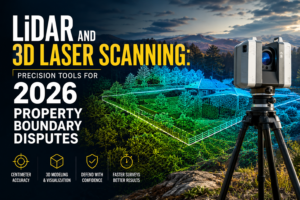
A surveyor can now capture a complete measured record of a five-storey Victorian warehouse in under two hours using a handheld laser scanner — a task that once took a team of three the better part of a week. That shift is not theoretical. It is happening across UK practices right now, and it is reshaping how defects are found, how valuations are evidenced, and how clients receive reports. This article cuts through the technology hype to show how using digital tools in UK valuation and building surveys: practical workflows with BIM, laser scanning and drones can be embedded into everyday surveying practice — not just headline projects.
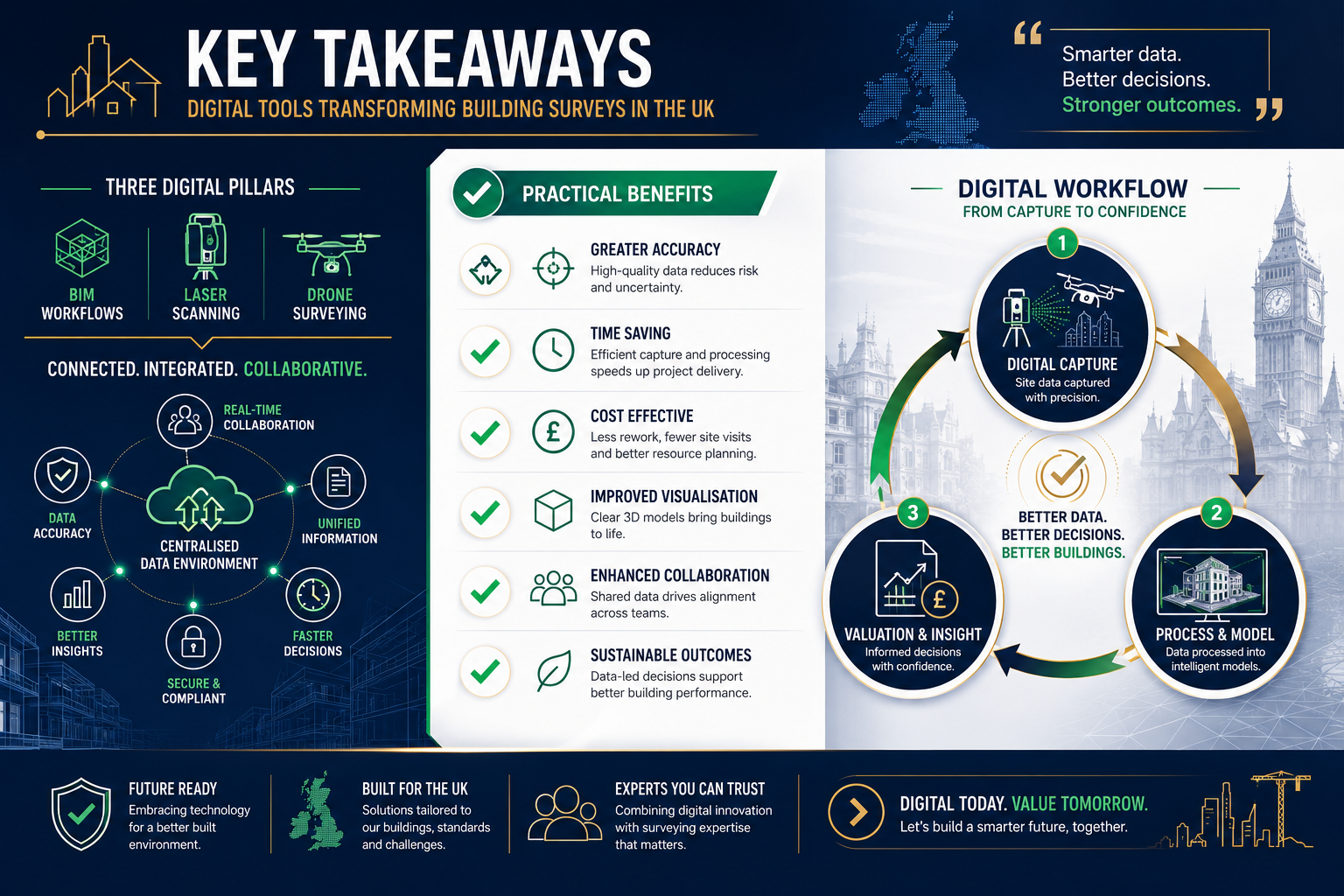
Key Takeaways
- BIM adoption among UK construction professionals reached 73% in 2025, making it a mainstream rather than specialist skill [4]
- RICS formally integrated drone and AI-assisted data collection into Level 3 survey protocols in February 2026 [1]
- Drone-based condition reporting can reduce typical survey costs by 53% to 70% on suitable projects [2]
- Digital tools add the most value when matched to specific project complexity — not every survey needs every technology
- Point cloud data from laser scanning and drone photogrammetry feeds directly into BIM models, creating a single auditable evidence base for valuations and defect reports
The Technology Landscape: What UK Surveyors Are Actually Using
The building surveying sector has moved well beyond pilot schemes. By late 2025, technologies including BIM, 3D laser scanning, thermal imaging, drones, and digital twins had become standard considerations on any survey involving complex geometry, restricted access, or high-value assets [6]. Understanding what each tool does — and where it fits in a practical workflow — is the starting point for any surveyor looking to upgrade their practice.
3D Laser Scanning and Point Clouds
A terrestrial laser scanner fires millions of infrared pulses per second and records the return time of each pulse to build a dense three-dimensional point cloud. Modern instruments achieve accuracies of plus or minus 2 mm at distances up to 30 metres. The output is a navigable, measurable record of every visible surface in a building.
Practical uses in surveying:
- Generating accurate floor plans, sections, and elevations for RICS building surveys without relying on tape measure and sketch
- Comparing as-built conditions against original drawings to identify structural movement or unauthorised alterations
- Providing a defensible record for schedule of dilapidations disputes, where precise measurements of damage are contested
- Supporting subsidence surveys by capturing wall lean, floor level changes, and crack profiles with millimetre precision
The scans are processed in software such as Autodesk ReCap or Leica Cyclone to produce a registered point cloud, which can then be imported directly into a BIM authoring environment.
BIM: From Construction Tool to Survey Asset
Building Information Modelling is no longer confined to new construction. BIM adoption among UK construction and property professionals reached 73% in 2025 [4], and the workflow is increasingly applied to existing buildings — sometimes called "scan-to-BIM." A point cloud captured on site becomes the geometric skeleton of a Revit or ArchiCAD model, onto which surveyors attach condition data, defect photographs, material specifications, and maintenance schedules.
In September 2025, Rapleys launched a dedicated Measured Surveys and Geomatics service offering comprehensive measured building surveys, BIM models, and topographical surveys, citing demand from property managers who need reliable data for long-term asset decisions [5]. That commercial move reflects a broader trend: clients increasingly expect a structured data model, not just a PDF report.
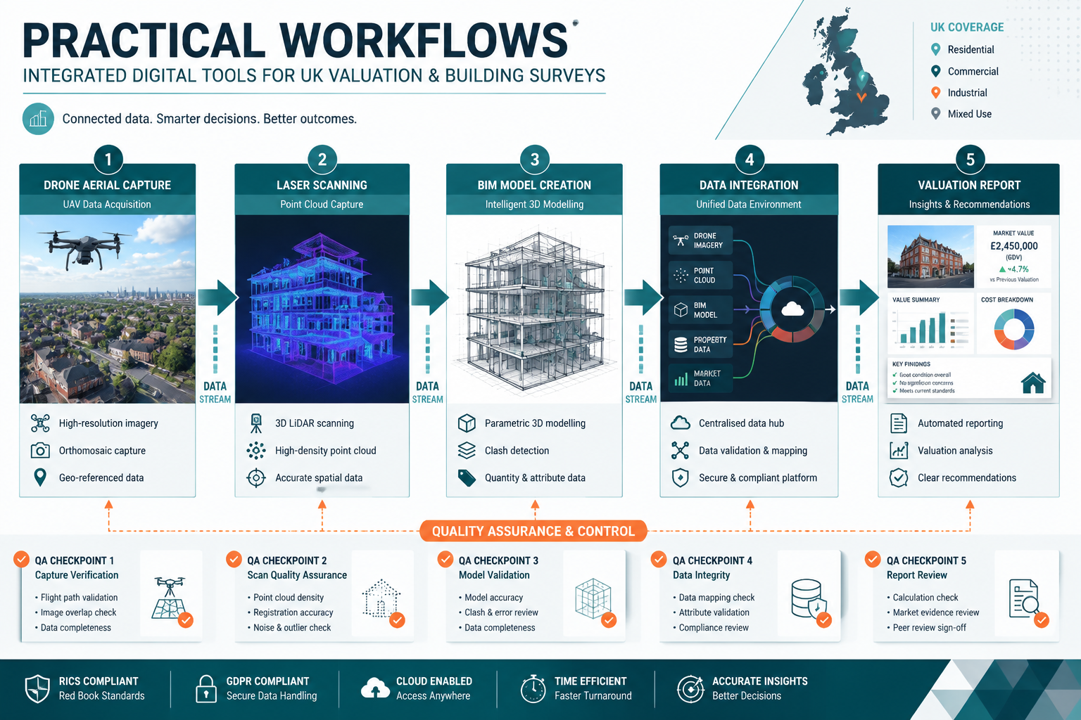
What a scan-to-BIM workflow looks like in practice:
| Stage | Action | Output |
|---|---|---|
| Pre-survey | Review existing drawings, agree Level of Detail (LOD) | Survey brief |
| Site capture | Laser scan all accessible areas, drone exterior | Registered point cloud |
| Modelling | Import point cloud, trace geometry in Revit/ArchiCAD | BIM model (LOD 200-300) |
| Condition tagging | Attach defect notes, photos, priority ratings | Annotated model |
| Reporting | Export schedules, drawings, 3D views | Client deliverable |
Drones: Practical Access Where Ladders Cannot Go
Unmanned aerial vehicles (UAVs) have become a routine part of exterior inspections for roofs, parapets, chimney stacks, high-level cladding, and large-footprint industrial buildings. In February 2026, RICS updated its Home Survey Standard to formally integrate drone and AI-assisted data collection into Level 3 survey protocols, recognising that drones improve defect detection accuracy on elements that are otherwise inaccessible without scaffolding [1].
The cost argument is compelling. CAM Drone Services reported that their drone-based condition reporting service achieved a 53% to 70% reduction in typical survey costs compared with traditional access methods, by capturing high-resolution visual, thermal, and spatial data in a single flight [2]. For a large commercial roof or a multi-storey residential block, the saving on scaffold hire alone often justifies the drone deployment.
"Drones and laser scanning add significant value in complex or inaccessible building surveys, but their benefits are context-dependent and their use should be tailored to specific project needs." [8]
That caveat matters. A standard two-bedroom terrace house rarely needs a drone survey. The technology earns its place on large, complex, or high-risk properties where traditional access is expensive, slow, or dangerous.
Practical Workflows: Integrating Digital Tools in UK Valuation and Building Surveys
The real value of using digital tools in UK valuation and building surveys — practical workflows with BIM, laser scanning and drones — emerges when the technologies are combined into a coherent process rather than used in isolation. Here is how that integration works across the most common survey types.
Level 3 Building Surveys and Defect Analysis
A RICS Level 3 building survey is the most detailed residential survey available, covering structure, fabric, services, and grounds. Digital tools strengthen each phase:
Pre-inspection: Aerial drone footage captured before the site visit allows the surveyor to plan access, identify obvious roof defects, and brief the client on likely areas of concern. This reduces on-site time and improves the quality of the inspection.
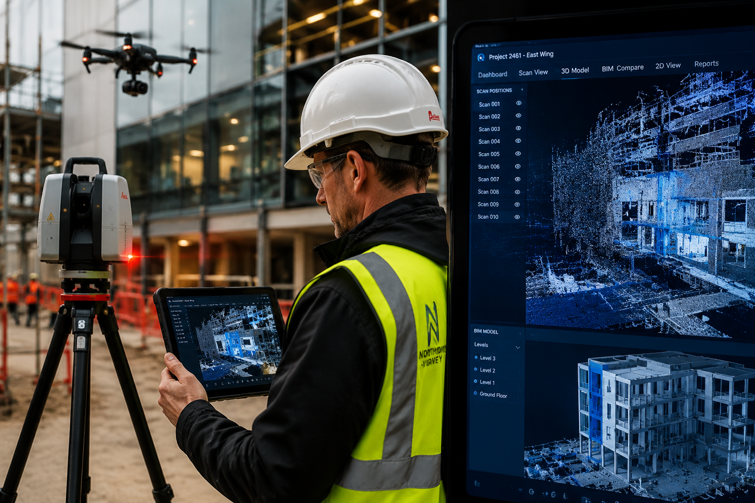
On-site capture: A handheld scanner or tripod-mounted unit captures interior geometry. Simultaneously, a drone operator (who may be the same surveyor with appropriate CAA permissions) flies the exterior. Thermal imaging attached to the drone identifies heat loss, moisture ingress, and cold bridges that are invisible to the naked eye.
Post-processing: Point cloud data is cleaned and registered. Key defects — a bowed wall, a sagging roof plane, a cracked parapet — are measured precisely and visualised in 3D. These measurements appear directly in the survey report with annotated screenshots, giving clients clear evidence rather than subjective descriptions.
By November 2025, the adoption of Ground-Penetrating Radar (GPR) alongside drones and 3D scanning had become essential for detailed surveys, enabling surveyors to gather information about buried services, voids, and reinforcement without disrupting the building fabric [9].
Commercial Building Surveys and Dilapidations
For commercial building surveys, the stakes around measured accuracy are higher. Lease-end dilapidations claims can run to hundreds of thousands of pounds, and disputes often hinge on whether a defect existed at lease commencement or developed during the term.
A laser scan captured at lease start, registered against a BIM model and stored securely, creates an unambiguous baseline. At lease end, a second scan is compared against the first using change-detection algorithms. The output is a colour-coded deviation map showing exactly where the building condition has changed — a powerful tool for dilapidation surveys and negotiations.
Key benefits for commercial work:
- Eliminates measurement disputes with objective point cloud evidence
- Accelerates schedule of condition production by 40-60% compared with manual methods
- Supports expert witness reports with photogrammetric evidence that withstands legal scrutiny
- Enables remote review by legal teams and clients without repeat site visits
Valuations: Strengthening the Evidence Base
Digital capture tools are increasingly relevant to RICS Red Book valuations, particularly for complex or unusual properties where comparable evidence is limited. A BIM model with accurate floor areas, condition data, and photographic records provides a richer evidence base than a traditional site notes file.
For RICS reinstatement cost assessments, accurate measured data is fundamental. Errors in gross internal area directly translate into errors in rebuild cost, which affects insurance premiums. A scan-to-BIM approach eliminates the manual measurement errors that have historically led to underinsurance.
The London Borough of Harrow demonstrated the asset management application in April 2026, launching a digital twin built from high-resolution drone imagery that enables remote building inspections and more cost-effective maintenance surveys across its property portfolio [3]. While a local authority estate differs from a single commercial valuation, the principle is identical: accurate spatial data, captured once and maintained over time, reduces the cost and improves the quality of every subsequent assessment.
Monitoring Surveys and Ongoing Asset Management
Monitoring surveys — used to track structural movement, settlement, or crack progression over time — are transformed by digital tools. Repeated laser scans at defined intervals, registered to a common coordinate system, detect movements of less than 1 mm. Automated comparison reports flag threshold exceedances without requiring a surveyor to re-examine every element manually.
AMP8 utility infrastructure projects have adopted drone surveys for as-built records, achieving centimetre-level accuracy and integrating outputs directly into BIM models for ongoing asset management [7]. The same workflow applies to large commercial estates, heritage buildings under conservation management, or any asset where condition change over time is a material concern.
Regulatory Compliance, Limitations, and Choosing the Right Tool
CAA Regulations and RICS Standards
Drone operations in the UK are governed by the Civil Aviation Authority (CAA) under the UK Drone and Model Aircraft Registration and Education Service (DMARES) framework. Surveyors operating drones commercially must hold an Operational Authorisation or work with a sub-contracted operator who does. Flying near aerodromes, over crowds, or beyond visual line of sight requires additional permissions.
RICS guidance, updated in 2026, requires that drone data collected as part of a Level 3 survey be captured by a competent operator and that the limitations of aerial inspection — including elements obscured by vegetation or adjacent structures — be clearly stated in the report [1].
When Digital Tools Add Value and When They Do Not
Not every project justifies the additional setup time and cost of laser scanning or drone deployment. The following framework helps surveyors make that decision:
High value for digital tools:
- Buildings over 500 sq m or with complex geometry
- Roofs or facades inaccessible without scaffolding
- Heritage or listed buildings where physical intervention must be minimised
- Dilapidations cases with anticipated legal dispute
- Valuation of non-standard construction or unusual properties
Lower value for digital tools:
- Standard residential properties with straightforward access
- Surveys where the client's budget does not support the additional cost
- Properties where existing accurate drawings are available and conditions are simple
The honest answer is that technology should serve the survey, not the other way around. A surveyor who deploys a drone on every instruction regardless of need is adding cost without adding proportionate value [8].
Data Management and Professional Liability
Point cloud files are large — a typical commercial building scan produces 10-50 gigabytes of raw data. Practices adopting these workflows need clear protocols for data storage, version control, client data sharing, and retention periods. BIM models containing condition assessments are professional documents and carry the same liability implications as written reports.
GDPR compliance is also relevant when drone imagery captures neighbouring properties or public spaces. Surveyors should document their data minimisation approach and ensure footage is not retained beyond its operational purpose.
Conclusion
The case for using digital tools in UK valuation and building surveys — practical workflows with BIM, laser scanning and drones — rests not on novelty but on demonstrable improvements in accuracy, efficiency, and client value. BIM adoption at 73% across the UK construction sector [4], RICS-endorsed drone protocols [1], and real-world cost reductions of up to 70% on suitable projects [2] confirm that these are mainstream professional tools, not experimental additions.
Actionable next steps for surveying practices:
- Audit current survey types to identify which instructions would most benefit from laser scanning, drone inspection, or scan-to-BIM workflows — start with commercial surveys and Level 3 residential instructions on complex properties.
- Invest in competency before equipment — RICS-accredited CPD courses in BIM and drone operations are available and should precede any hardware purchase.
- Obtain or subcontract CAA authorisation for drone operations before marketing aerial inspection services.
- Update fee proposals to reflect the genuine cost savings digital tools can deliver on access-restricted or large-footprint properties, framing technology as a client benefit rather than a premium add-on.
- Establish a data management protocol covering point cloud storage, BIM model versioning, and GDPR-compliant drone footage retention before the first digital survey is delivered.
Practices that embed these workflows now will be better positioned to meet client expectations, support complex valuation evidence, and operate efficiently as the RICS continues to formalise digital standards across all survey levels.
References
[1] Drones And Laser Scanning In Level 3 Building Surveys 2026 Rics Protocols For Precision Defect Detection – https://manchestersurveyors.com/drones-and-laser-scanning-in-level-3-building-surveys-2026-rics-protocols-for-precision-defect-detection/?utm_source=openai
[2] Cam Drone Services Unveils Precision Asset Intelligence To Slash Property Maintenance Costs By 70 – https://www.londondaily.news/cam-drone-services-unveils-precision-asset-intelligence-to-slash-property-maintenance-costs-by-70/?utm_source=openai
[3] Harrow's Digital Twin Cuts Maintenance Costs Enables Remote Building Inspections – https://www.pbctoday.co.uk/news/digital-construction-news/harrows-digital-twin-cuts-maintenance-costs-enables-remote-building-inspections/161169/?utm_source=openai
[4] The Rise Of Bim In The Uk – https://www.trimble.com/blog/construction/en-US/article/the-rise-of-bim-in-the-uk?utm_source=openai
[5] Rapleys Launches New Measured Surveys And Geomatics Service As It Continues To Expand The Business – https://rapleys.com/rapleys-launches-new-measured-surveys-and-geomatics-service-as-it-continues-to-expand-the-business?utm_source=openai
[6] Shw Building Surveying The 2025 Trends Challenges – https://www.shw.co.uk/articles/2025/shw—building-surveying—the-2025-trends–challenges.html?utm_source=openai
[7] Amp8 Utility Projects Start With Precise As Build Surveys And Bim Models – https://prodroneworx.temporarywebsiteaddress.com/news/amp8-utility-projects-start-with-precise-as-build-surveys-and-bim-models?utm_source=openai
[8] Using Drones Laser Scanning And Ar In Uk Building Surveys What Actually Adds Value For Clients And What Doesnt – https://wimbledonsurveyors.com/using-drones-laser-scanning-and-ar-in-uk-building-surveys-what-actually-adds-value-for-clients-and-what-doesnt/?utm_source=openai
[9] Building Survey Technology In 2026 Gpr Drones And 3d Scanning Explained – https://redboxsurveys.co.uk/building-survey-technology-in-2026-gpr-drones-and-3d-scanning-explained/?utm_source=openai