UK building surveyors who adopted drone and LiDAR workflows in 2026 are completing measured building surveys in a fraction of the time it once took, with point-cloud accuracy that routinely meets RICS tolerances. Yet the market for hardware, software, and managed services has expanded so rapidly that choosing the wrong combination can cost a practice thousands of pounds and weeks of rework. This guide cuts through the noise by comparing the leading options across every layer of the stack, from the drone on the roof to the BIM model on the client's desk.
Key Takeaways
- RTK-enabled drones and terrestrial LiDAR scanners now form the backbone of professional building survey workflows in the UK, with accuracy benchmarks that satisfy RICS standards.
- Regulatory compliance under the updated CAA Drone Code and Remote ID requirements is non-negotiable; surveyors must hold the appropriate GVC or A2 CofC qualification before flying near structures.
- Software integration, particularly the pipeline from point-cloud capture to scan-to-BIM, is where most workflow efficiency is won or lost.
- Costs for drone and LiDAR surveys vary widely, but the business case for scan-to-BIM before renovation or refurbishment projects is well established.
- Managed service providers offer a credible alternative for practices that lack in-house drone operators or scanning specialists.
Hardware Options: Drones, LiDAR Scanners, and Cameras
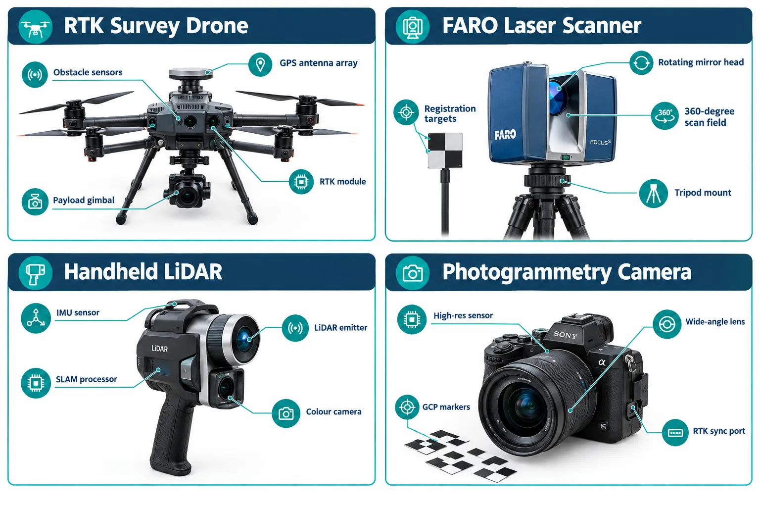
Selecting the right hardware is the first and most consequential decision when building a drone and 3D scanning capability. The best drone and 3D scanning tools for UK building surveyors span three distinct hardware categories: survey-grade drones, terrestrial laser scanners, and handheld LiDAR devices.
Survey-Grade Drones
DJI Matrice 350 RTK remains the dominant platform for UK building surveys in 2026. Its integrated RTK module delivers horizontal accuracy of approximately 1 cm and vertical accuracy of 1.5 cm without ground control points, making it suitable for facade surveys, roof inspections, and topographic work around structures. The Matrice 350 RTK supports interchangeable payloads, including the Zenmuse P1 full-frame photogrammetry camera and the Zenmuse L2 LiDAR unit, which gives practices a single airframe for multiple survey types.
DJI Mavic 3 Enterprise offers a more portable and cost-effective entry point. While it lacks the raw payload capacity of the Matrice series, its 4/3 CMOS sensor and mechanical shutter make it a capable photogrammetry platform for smaller residential and commercial buildings.
Autel Robotics EVO II Pro is increasingly selected by practices seeking an alternative to DJI, particularly those working on sensitive government or infrastructure projects where supply-chain provenance is a consideration.
"RTK drones have fundamentally changed the accuracy conversation. Surveyors no longer need to spend half a day placing and surveying ground control points on every site." [5]
Terrestrial Laser Scanners
For interior surveys, heritage recording, and any scenario where drone access is impractical, terrestrial laser scanners remain indispensable.
FARO Focus Premium is the benchmark instrument for UK building surveyors. It delivers scan ranges up to 350 m, a measurement rate of up to 1 million points per second, and integrated HDR photography for colourised point clouds. FARO has continued to develop its ecosystem, with its 2026 roadmap emphasising tighter integration between hardware and cloud-based processing platforms [3].
Leica RTC360 competes directly with the FARO Focus, offering automatic target recognition and a field-ready workflow that reduces registration time on site. Its Visual Inertial System (VIS) enables faster traversal through complex building interiors.
Matterport Pro3 occupies a different market position: it is faster to deploy and easier to operate than either FARO or Leica instruments, but its spatial data is better suited to visualisation and condition reporting than to precision measured building surveys requiring sub-centimetre accuracy.
Handheld LiDAR Devices
GeoSLAM ZEB Horizon and NavVis M6 represent the handheld SLAM (Simultaneous Localisation and Mapping) category. These devices allow surveyors to walk through a building and capture a continuous point cloud without setting up a tripod at each station. Accuracy is lower than phase-based scanners, typically 1-3 cm, but the speed advantage is significant for large floor-plate buildings or multi-storey car parks.
| Device | Type | Typical Accuracy | Best Use Case |
|---|---|---|---|
| DJI Matrice 350 RTK + L2 | Aerial LiDAR | 1-3 cm | Roofs, facades, topographic |
| FARO Focus Premium | Terrestrial scanner | 1-2 mm | Interior, heritage, BIM |
| Leica RTC360 | Terrestrial scanner | 1-2 mm | Interior, rapid registration |
| GeoSLAM ZEB Horizon | Handheld SLAM | 1-3 cm | Large interiors, rapid capture |
| DJI Mavic 3 Enterprise | Aerial photogrammetry | 2-5 cm | Residential, small commercial |
Software Stack: Photogrammetry, Point-Cloud Processing, and BIM Integration
Hardware captures the data; software transforms it into deliverables. The best drone and 3D scanning tools for UK building surveyors depend as much on the software pipeline as on the instruments themselves. A well-chosen stack reduces processing time, improves accuracy, and produces outputs that integrate directly with client reporting tools.
Photogrammetry and Reality Capture
Agisoft Metashape is the most widely used photogrammetry application among UK surveyors. It processes drone imagery into dense point clouds, orthomosaics, and digital surface models, with Python scripting support for automated batch workflows. Accuracy in controlled conditions with RTK imagery routinely achieves 1-3 cm GSD (Ground Sampling Distance).
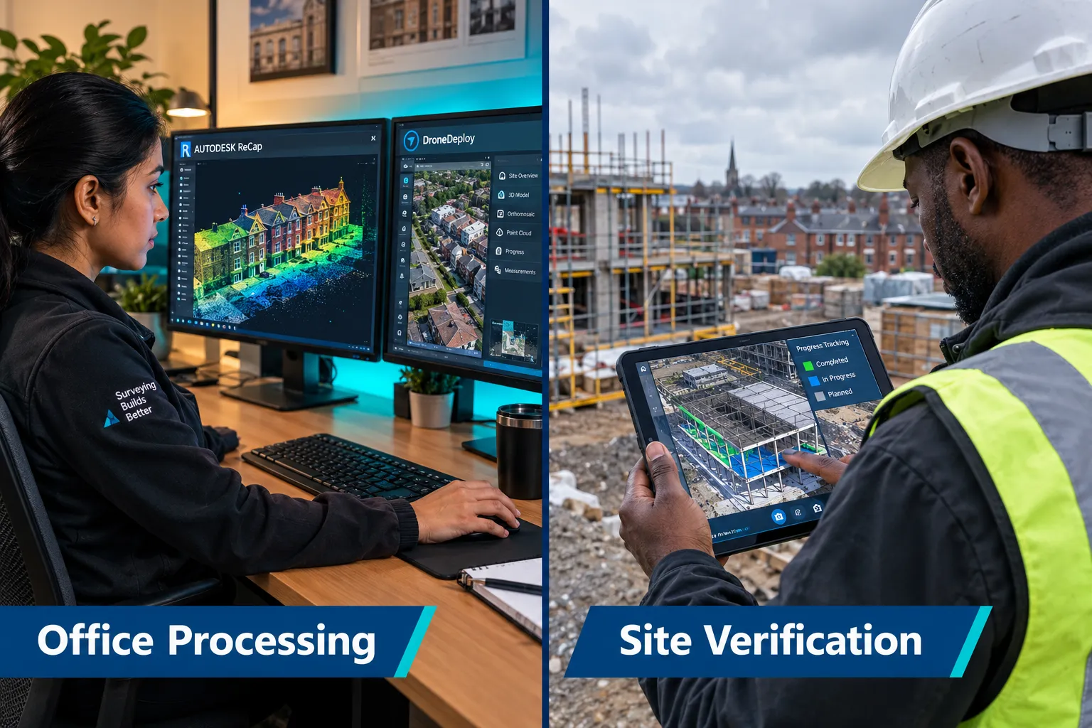
DroneDeploy combines flight planning, automated processing, and cloud delivery in a single platform. Its partnership with major UK contractors, including Kier Group, demonstrates its maturity as an enterprise tool [10]. DroneDeploy's AI-powered change detection and progress tracking features are particularly relevant for surveyors working on phased construction or refurbishment projects [4].
Autodesk ReCap serves as the primary point-cloud management environment for many UK practices. It ingests data from virtually every scanner and drone platform, registers multiple scan positions, and exports clean RCP/RCS files directly into Autodesk Revit for BIM modelling [8]. ReCap's cloud processing option reduces the burden on local hardware.
Point-Cloud Processing and Registration
FARO Scene is the native processing software for FARO scanners and offers automatic target-based and cloud-to-cloud registration. For mixed workflows combining FARO scans with drone data, Scene's export to E57 or PTX format ensures compatibility with third-party platforms.
Leica Cyclone REGISTER 360 provides a comparable workflow for Leica hardware, with an intuitive visual registration interface that reduces the skill barrier for less experienced operators.
Trimble RealWorks is preferred in practices with existing Trimble total station infrastructure, offering tight integration between conventional survey data and laser scan data.
BIM and Reporting Integration
Autodesk Revit remains the dominant BIM authoring tool for scan-to-BIM workflows in the UK. Point clouds imported via ReCap can be used as reference geometry for modelling walls, floors, roofs, and structural elements to LOD 300 or above.
Bentley iTwin is gaining ground on larger infrastructure and commercial projects, particularly where digital twin continuity beyond the construction phase is required [6].
Matterport's cloud platform, while not a BIM tool, produces shareable 3D walkthroughs that are increasingly used alongside formal survey deliverables for client communication and condition reporting [2].
Reality capture is shifting from a one-time data collection exercise to a continuous project intelligence layer [6]. Practices that build repeatable, automated pipelines between capture hardware and BIM authoring tools are positioning themselves for the next phase of this market.
Regulatory Compliance Software
Altitude Angel and NATS Drone Assist are the primary flight planning and airspace authorisation tools used by UK drone operators. Both integrate with the CAA's SORA (Specific Operations Risk Assessment) framework and support Remote ID compliance, which became mandatory for commercial operators in 2026 [1].
Regulatory Environment, Costs, and Service Providers
Understanding the regulatory landscape and cost structure is essential before committing to any hardware or software investment. The best drone and 3D scanning tools for UK building surveyors must be evaluated in the context of what is legally permissible and financially viable.
CAA Regulations and Compliance Requirements in 2026
The CAA's updated Drone Code, which came into full effect in early 2026, introduced several changes directly relevant to building surveyors. Remote ID is now mandatory for all commercial drone operations. Closer flight permissions near structures and people have been clarified, with the A2 Certificate of Competency (A2 CofC) permitting flight as close as 30 m to uninvolved persons in the A2 subcategory, and the General VLOS Certificate (GVC) enabling Specific Category operations under an Operational Authorisation [1].
Key compliance requirements for UK building surveyors using drones include:
- GVC or A2 CofC qualification for the remote pilot
- Operator registration with the CAA
- Operational Authorisation for any flight outside the Open Category
- Remote ID broadcast capability on the aircraft
- Public liability insurance with a minimum of 1 million EUR coverage for commercial operations
- Site-specific risk assessment (SORA or simplified equivalent) for each project
Failure to comply carries civil penalties and, in serious cases, criminal prosecution. Practices commissioning third-party drone operators should verify that the operator holds the appropriate authorisation before work begins.
Typical Costs for Drone and 3D Scanning Surveys
UK market pricing in 2026 reflects the maturation of the sector. Costs vary significantly by project complexity, building size, and deliverable specification.
- Drone photogrammetry survey (external, residential): approximately 500 to 1,500 GBP per property
- Drone LiDAR survey (commercial building, external): approximately 1,500 to 4,000 GBP
- Terrestrial laser scan (single building, internal and external): approximately 2,000 to 8,000 GBP depending on floor area
- Full scan-to-BIM (measured building survey to LOD 300): approximately 5,000 to 25,000 GBP for a typical commercial building
- Progress monitoring subscription (drone + platform): approximately 1,500 to 5,000 GBP per month for active construction sites [4]
The business case for investing in scan-to-BIM before renovation is compelling. Contractors report that accurate as-built data captured before works begin reduces design clashes, avoids costly on-site variations, and shortens the overall programme [7].
Managed Service Providers
Not every surveying practice needs to own and operate its own drone and scanning equipment. A growing ecosystem of specialist UK service providers offers turnkey solutions.
Flyby Technology, Consortiq, and Skytango are among the established UK operators offering drone survey services with CAA-compliant operators and full data processing pipelines. These providers typically deliver georeferenced orthomosaics, point clouds, and 3D models as standard deliverables.
For laser scanning, Plowman Craven, Measured Survey Services, and ArcTech have built reputations for large-scale measured building surveys and scan-to-BIM projects across the UK.
The emergence of smaller, regional operators has made professional drone and scanning services accessible to practices that previously could not justify the cost [9]. However, quality varies considerably. Practices should request sample deliverables, verify operator qualifications, and confirm that data formats are compatible with their own software stack before appointing a provider.
Integrated Workflows and Business Value
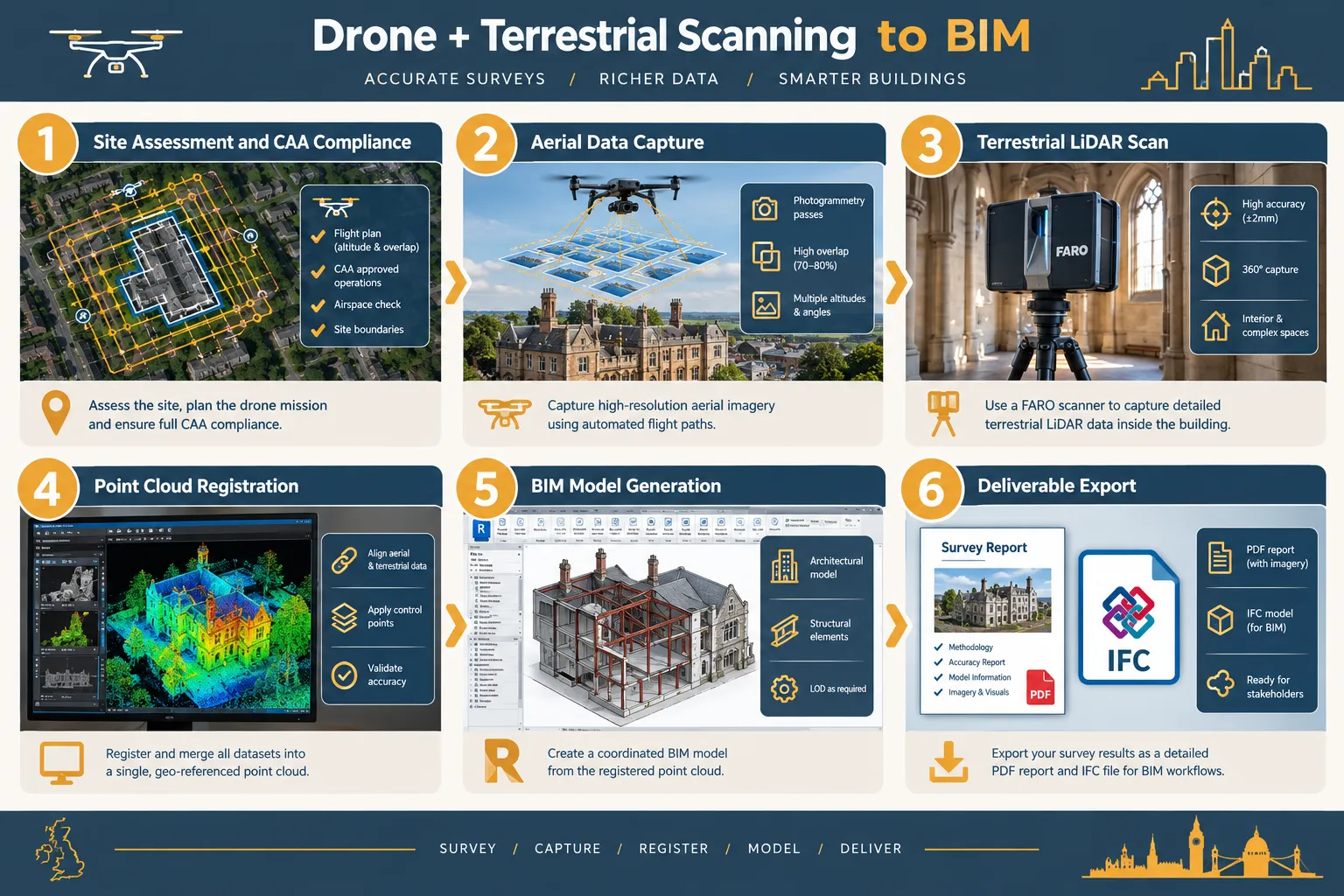
The most significant productivity gains come not from any single piece of hardware or software but from integrating drone data, terrestrial scan data, and AI-assisted processing into a single coherent workflow [5]. A well-designed integrated workflow for a typical UK building survey follows this sequence:
- Pre-flight site assessment and airspace authorisation
- Aerial drone survey capturing photogrammetry or LiDAR data of the roof and external facades
- Terrestrial laser scanning of internal spaces and areas inaccessible to the drone
- Point-cloud registration and merging in ReCap or FARO Scene
- Scan-to-BIM modelling in Revit to the agreed LOD
- Quality assurance against RICS survey tolerances
- Deliverable export in agreed formats (PDF drawings, IFC, RVT, point cloud)
AI tools are beginning to automate steps four and five, with platforms such as Reconstruct and Buildots offering automated comparison of point clouds against design models for progress tracking [4]. This reduces the manual effort of BIM modelling and opens new service lines for surveying practices.
Conclusion
The landscape for drone and 3D scanning in UK building surveying has reached genuine maturity. Hardware from DJI, FARO, and Leica sets a high accuracy baseline; software platforms from Autodesk, DroneDeploy, and Agisoft provide the processing and integration layer; and a well-developed service provider market means that even smaller practices can access professional-grade data capture without capital investment in equipment.
Actionable next steps for UK building surveyors in 2026:
- Audit current survey workflows to identify where drone or LiDAR data capture would reduce time on site or improve deliverable quality.
- Confirm that any in-house or contracted drone operator holds the correct CAA authorisation, including GVC or A2 CofC and Remote ID-compliant hardware.
- Pilot Autodesk ReCap as a point-cloud hub if the practice already uses Revit, as this offers the lowest-friction path to scan-to-BIM capability.
- Evaluate DroneDeploy or a comparable platform for any projects involving phased construction monitoring, where repeat flights and change detection add measurable client value.
- Request sample deliverables from at least two managed service providers before appointing one, and verify format compatibility with the practice's reporting tools.
The practices that invest in building these capabilities now, whether in-house or through trusted partners, will be best placed to meet client expectations as scan-to-BIM and digital twin requirements become standard on UK building projects.
References
[1] From January Your Building Can Captured 3d Like William Beck K1l9f – linkedin.com
[2] pbctoday.co.uk – pbctoday.co.uk
[3] pbctoday.co.uk – pbctoday.co.uk
[4] The Best Progress Tracking Solutions For Construction – ukconstructionblog.co.uk
[5] How To Integrate Drone Data Into Bim A Professional Guide For 2026 – impactaerial.co.uk
[6] pbctoday.co.uk – pbctoday.co.uk
[7] Why General Contractors Are Investing In Reality Capture Scan To Bim Before Renovation Projects Begin – ukconstructionblog.co.uk
[8] Overview – autodesk.com
[9] pbctoday.co.uk – pbctoday.co.uk
[10] Kier Group Partners With Dronedeploy – dronedeploy.com