Fewer than one in three UK building surveyors consistently delivered structured BIM outputs from their inspection workflows as recently as five years ago. By 2026, that gap has become a competitive liability. BIM integration in UK building surveys, from 3D models to condition and valuation data, is no longer a specialist niche. It is embedded in RICS professional standards, mandated on public-sector projects, and increasingly expected by commercial clients who want a single, queryable source of truth for their assets. This article explains what that integration looks like in practice, how surveyors can build it into their inspection and reporting workflows, and what the data exchange and software landscape looks like today.
Key Takeaways
- RICS professional standards now formally include a BIM management competency, and all UK central-government-procured projects must comply with ISO 19650.
- A modern UK measured building survey can produce three deliverable tiers: 2D drawings, 3D point clouds, and fully attributed BIM models in Revit or IFC format.
- Level of Detail (LOD) targets typically range from LOD 200 for general architecture to LOD 400-500 for critical structural, MEP, or asset management outputs.
- BIM models can carry condition data, defect photographs, valuation attributes, and maintenance records, making them a foundation for the "golden thread" of building information.
- The RICS Responsible Use of Artificial Intelligence standard, effective March 2026, requires surveyors to disclose AI tools used in BIM-based workflows and maintain a BIM and AI risk register.
Why BIM Is Now Central to UK Building Surveying Practice
The shift from drawings to data-rich models did not happen overnight, but the regulatory and professional framework has now made it structural. RICS construction standards include a BIM guidance note that sets international high-level principles for implementing and using BIM across design, construction, and operation [5]. The expectation is explicit: survey outputs should integrate into lifecycle BIM models rather than remaining as standalone drawings [3].
At the professional competency level, the December 2025 RICS Building Surveying profile formally lists Building information modelling (BIM) management as a competency, requiring surveyors to understand collaborative processes and the technological principles for establishing and managing information modelling systems on projects [1][2]. This is not an optional add-on. It sits alongside core technical competencies in the pathway guide for chartered surveyors [2].
On the procurement side, the UK BIM Framework, applying ISO 19650, is described in 2026 guidance as the minimum expectation for public-sector procurement. All UK central-government-procured projects must demonstrate BIM compliance aligned to ISO 19650 [10]. For quantity surveyors and project teams, this means defining BIM scope and level at the pre-appointment stage, confirming the ISO 19650 stage, and agreeing software and file requirements including IFC and COBie [10].
What This Means for Day-to-Day Survey Practice
The practical consequence is straightforward. A surveyor commissioned to carry out a measured building survey, a condition survey, or a pre-acquisition inspection on a public or large commercial asset is now expected to:
- Confirm whether a BIM model already exists and at what LOD
- Agree the deliverable format (IFC, Revit, COBie, or a combination) before mobilising
- Understand how their survey data will feed into downstream design, cost, or FM workflows
- Disclose any AI tools used in processing, take-off, or risk analysis, and maintain a BIM and AI risk register [10]
The last point reflects the RICS Responsible Use of Artificial Intelligence in Surveying Practice standard, effective 9 March 2026, which applies directly to BIM-based workflows including automated take-off and model-based estimating [10].
From Point Cloud to BIM Model: The Core Technical Workflow
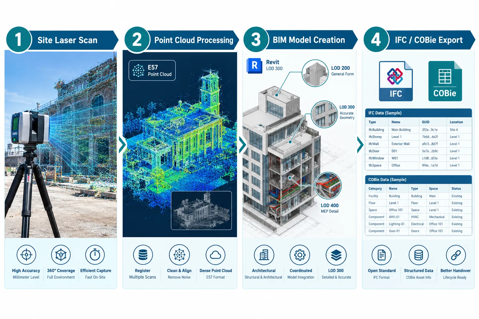
The technical backbone of BIM integration in UK building surveys, from 3D models to condition and valuation data, is the scan-to-BIM process. Understanding it in detail is essential for surveyors who want to specify, commission, or quality-assure BIM-ready outputs.
Step 1, Site Data Capture
Terrestrial laser scanning (TLS) using instruments such as Leica RTC360, FARO Focus, or Trimble X7 produces a dense point cloud of the building interior and exterior. The output is typically stored in E57 or RCP format. For smaller or access-restricted areas, photogrammetry or structured-light scanning may supplement TLS data.
The governing technical standard is the RICS Measured Surveys of Land, Buildings and Utilities, 3rd edition, which has been reissued as a global professional standard and updated online in August 2026 [7][11]. Section 8 of that standard covers deliverables, and Section 8.17 addresses BIM considerations specifically, confirming that point-cloud-derived BIM models are supported provided accuracy and feature requirements are met [7][11].
Step 2, Point Cloud Registration and Processing
Raw scans are registered (aligned) in software such as Leica Cyclone REGISTER 360, FARO SCENE, or Autodesk ReCap. The result is a unified, georeferenced point cloud. At this stage, accuracy checks against control points are critical, and the surveyor must document the achieved accuracy against the tolerances specified in the RICS standard.
Step 3, BIM Model Creation (Scan-to-BIM)
The registered point cloud is imported into a BIM authoring tool, most commonly Autodesk Revit, and used as a reference to model building elements. The target LOD determines the effort and cost involved.
LOD definitions in UK 2026 practice [7][13]:
| LOD | Description | Typical Use |
|---|---|---|
| 200 | General massing, approximate dimensions | Feasibility, planning |
| 300 | Accurate geometry, specific assemblies | Design coordination |
| 350 | Interfaces between elements modelled | Clash detection |
| 400 | Full fabrication and assembly detail | MEP, structural |
| 500 | As-built with asset data attributes | FM, golden thread |
UK 2026 practice typically targets LOD 200-300 for general architecture and LOD 300-400 for critical structural or MEP elements [7][13]. An optional LOD 500 model, aligned with ISO 19650, is specified for as-built surveys where the output will feed directly into a facility management or asset information model [12][11].
Step 4, Data Exchange and Deliverables
A 2026 analysis of UK survey deliverables identifies three standard output categories: 2D drawings, 3D point clouds, and 3D BIM models [13][7]. BIM-ready outputs now commonly include:
- Revit (.rvt) files, the native authoring format
- IFC files, the open, software-neutral exchange format required for ISO 19650 compliance
- COBie spreadsheets, structured asset data for FM handover
- PDF plans, for non-BIM stakeholders
- Point clouds (E57/RCP), as a verifiable geometric record
- Photographs mapped onto the model, providing condition context and visual evidence [13][7]
This combination makes the survey a single source for geometry, condition context, and structured asset data, a significant step beyond traditional drawing packages.
Integrating Condition, Defect, and Valuation Data into BIM Models
The geometry of a building is only part of what a surveyor contributes. The greater professional value lies in attaching condition assessments, defect records, and valuation-relevant attributes to the model elements. This is where BIM integration in UK building surveys, from 3D models to condition and valuation data, delivers its most tangible client benefit.

Condition Data and Defect Logging
In a BIM-enabled condition survey, each building element, a roof covering, a window frame, a structural beam, is represented as a model object with associated parameters. The surveyor can assign:
- Condition rating (e.g., Grade 1-5 per RICS or NRM3 definitions)
- Defect type and severity (cracking, spalling, moisture ingress, etc.)
- Photographic evidence linked directly to the element
- Recommended action and priority
- Estimated remediation cost linked to NRM cost data
This approach transforms a written schedule of condition into a queryable, filterable dataset. A client can interrogate the model to identify all elements rated Grade 3 or worse, extract a cost plan for immediate repairs, or export the data to a CAFM (Computer-Aided Facilities Management) system.
The RICS standard for surveying assets in the built environment provides the professional framework for structuring this data [8]. When combined with the ISO 19650 asset information model requirements, the result is a condition record that supports the "golden thread" of building information, the continuous, auditable data trail required under the Building Safety Act 2022.
Valuation Data in BIM Workflows
Integrating valuation data into a BIM model is a more recent development, but the infrastructure is now in place. COBie attributes can carry:
- Gross Internal Area (GIA) and Net Internal Area (NIA) calculated directly from the model
- Floor-by-floor area schedules for rent review or rating purposes
- Asset replacement values linked to element quantities
- Lease demise boundaries modelled as separate zones
For quantity surveyors, the 2026 guidance specifies that BIM models are explicitly intended for uses such as cost modelling and structured project information [10]. Model-based take-off, where quantities are extracted directly from the BIM geometry rather than measured from drawings, reduces error and accelerates the valuation process.
A BIM model that carries both geometric accuracy and structured asset data is not just a survey deliverable, it is a living asset register that supports every downstream decision from lease renewal to major works procurement.
Software Choices for Condition and Valuation Integration
Surveyors working in this space need to make deliberate software choices. The following tools are commonly used in UK practice in 2026:
- Autodesk Revit, primary BIM authoring for geometry and parameter management
- Autodesk BIM 360 / Autodesk Construction Cloud, cloud-based collaboration and issue tracking
- Dalux Field / Fieldwire, mobile-first defect logging linked to BIM model elements on site
- ARCHIBUS / Planon, CAFM integration for condition and maintenance data
- Microsoft Excel / Power BI, COBie data validation and reporting dashboards
- Leica Cyclone / FARO SCENE, point cloud processing before BIM authoring
The choice of software should be agreed with the client and design team at the pre-appointment stage, with IFC as the neutral exchange format ensuring interoperability regardless of which authoring tool is used [10].
Costs, Procurement, and Practical Considerations for BIM-Integrated Surveys
Understanding the cost structure of BIM-integrated surveys helps both surveyors and clients make informed procurement decisions. The investment in richer deliverables is real, but so is the downstream value.

Typical Cost Ranges in 2026
Cost data from UK providers in 2026 illustrates the relationship between LOD and price. For scan-to-BIM work, market pricing shows LOD 200 models at roughly £0.30-£0.60 per square foot, LOD 300 at about £0.40-£0.80 per square foot, and LOD 350 at around £0.60-£1.00 per square foot, with measured building survey packages for larger properties often exceeding £5,000 [4].
Per-floor pricing from another UK provider in late 2026 shows geometric LOD 200 starting around £1,499 per floor, design-ready LOD 300 at approximately £1,799, and LOD 400 with full MEP and structural detail at around £2,299, while point-cloud capture alone starts from roughly £799 [9]. This illustrates clearly that richer BIM and asset data come at a distinct cost premium over basic geometry.
For full BIM-integrated surveys by project type, 2026 cost bands are [12]:
- Small residential, £800-£1,500 mid-range; £1,500-£3,000+ for complex/LOD 500 output
- Medium commercial/office fit-out, £2,000-£5,000 mid-range; £5,000-£12,000+ high-complexity
- Large commercial/industrial/BIM projects, £8,000-£15,000+ mid-range; £15,000-£30,000+ high-complexity
Key Procurement Checklist
When commissioning or delivering a BIM-integrated building survey, the following items should be confirmed at the pre-appointment stage [10]:
- BIM scope and level, what LOD is required for each element type?
- ISO 19650 stage, is this a new project, an existing asset, or a handover?
- Software and file requirements, Revit version, IFC schema (IFC2x3 or IFC4), COBie template
- Accuracy tolerances, per RICS Measured Surveys 3rd edition [11]
- AI tool disclosure, any AI used in processing, take-off, or risk analysis must be declared [10]
- BIM and AI risk register, covering model integrity, version control, AI hallucinations, and cyber-security [10]
- Deliverable schedule, milestones for point cloud, draft model, final IFC, and COBie
Common Mistakes to Avoid
Experienced BIM managers and surveyors consistently identify the same failure points [4]:
- Under-specifying LOD at the outset, leading to expensive rework when the model cannot support downstream design or FM use
- Failing to agree coordinate systems, causing misalignment when the survey model is federated with architect or structural models
- Omitting COBie requirements, the geometry may be correct but the asset data fields are empty, making FM handover impossible
- Not validating IFC exports, Revit-to-IFC translation can lose parameter data; validation with a tool such as Solibri or BIMcollab is essential
- Treating the point cloud as the deliverable, a point cloud is a capture medium, not a BIM model; clients expecting a queryable asset model need the full scan-to-BIM workflow
Conclusion
BIM integration in UK building surveys, from 3D models to condition and valuation data, has moved from aspiration to professional expectation. RICS competency frameworks, ISO 19650 procurement requirements, and the Building Safety Act's golden thread obligation have collectively created a landscape where surveyors who cannot deliver structured, attributed BIM outputs are at a growing disadvantage.
Actionable next steps for surveyors and practices in 2026:
- Audit your current deliverables. If your standard survey output is a PDF or a 2D CAD file, identify which project types would benefit most from a BIM-ready upgrade and price accordingly.
- Invest in LOD literacy. Ensure every fee earner understands the difference between LOD 200, 300, and 500, and can articulate the value of each to a client.
- Establish a pre-appointment BIM checklist. Use the ISO 19650 framework and the 2026 RICS QS guidance note as a template for scoping BIM deliverables at the proposal stage [10].
- Build a BIM and AI risk register. The RICS AI standard effective March 2026 requires this for any practice using AI tools in BIM-based workflows [10].
- Develop software partnerships. Identify a scan-to-BIM specialist or invest in in-house Revit capability, and agree IFC as the standard exchange format for all projects.
- Link condition data to cost. Move beyond written schedules of condition by attaching NRM-based cost estimates to BIM elements, giving clients an immediately actionable asset management tool.
The surveyor who delivers a georeferenced, LOD 300 Revit model with embedded condition ratings, COBie asset data, and linked photographic evidence is not just meeting a technical standard. They are providing a foundation for every decision the building owner will make over the next decade.
References
[1] Building Surveying December 2025 – rics.org
[2] Building Surveying Pathway Guide Chartered Rics – rics.org
[3] International Bim Implementation Guide 1st Edition Rics – rics.org
[4] Measured Building Surveys For Bim Managers Scope Outputs And Common Mistakes – icelabz.co.uk
[5] Construction Standards – rics.org
[7] The Complete Guide To Measured Building Surveys – icelabz.co.uk
[8] Surveying Assets In The Built Environment – aemdev.rics.org
[9] Pricing – skyscansurveys.co.uk
[10] Gn Pa 15 – qsguidancenotes.com
[11] RICS Measured Surveys of Land, Buildings and Utilities, 3rd edition (referenced via sources [7] and [12])
[12] As-built survey guide (referenced via source [7] context)
[13] Measured building survey deliverables guide (referenced via source [7] context)