
}

By 2026, 63% of surveying and land analysis companies have adopted cloud-based or AI-assisted digital tools as a core part of their workflow [5] — a statistic that signals not just a trend, but a fundamental restructuring of how property surveys are delivered, shared, and acted upon. The era of emailing a static PDF and waiting days for client feedback is, for most forward-thinking firms, firmly in the past.
Cloud-Based Platforms for Interactive Property Surveys: Real-Time Collaboration in 2026 represents the convergence of several powerful forces: browser-based 3D visualization, instant file sharing, synchronized field-to-office data pipelines, and collaborative workspaces where clients, engineers, and surveyors all work from a single, always-current source of truth [1]. This article unpacks what that means in practice, which technologies are driving the shift, and how property professionals can make the most of these capabilities right now.
Key Takeaways 📌
- Static survey reports are being replaced by interactive, browser-based 3D models and cloud dashboards that multiple stakeholders can access simultaneously.
- Real-time collaboration — including live annotations, comment threads, and version syncing — is now an expected deliverable, not a premium add-on.
- Digital twins of properties and land parcels are becoming the standard survey output for complex or high-value projects in 2026.
- Reality capture tools (drones, laser scanners, 360° cameras) feed directly into cloud platforms, dramatically cutting turnaround times.
- Clients and remote teams benefit most: no specialist software needed, just a browser and an internet connection.
Why Static Reports No Longer Cut It in 2026
For decades, the standard survey deliverable was a PDF or printed report — a snapshot of a property at a single moment in time, delivered days after the site visit. Clients received it, read it (or didn't), and filed it away. Collaboration meant emailing marked-up copies back and forth, often losing track of which version was current.
That model has a fundamental flaw: property decisions rarely involve just one person. A buyer, their solicitor, a structural engineer, a mortgage lender, and a project manager may all need to interrogate the same survey data — simultaneously, from different locations.
"The shift to cloud-based platforms is the most significant change in how survey data is captured and shared that the industry has seen in a generation." — UK surveying practice commentary, 2026 [1]
Industry analysis confirms that clients now expect instant, cloud-based access to survey outputs rather than waiting for emailed files [1]. The demand is not just for speed — it is for interactivity. Users want to zoom into a specific wall, click on a defect marker, read the associated note, and leave a comment for the surveyor, all without downloading a single file.
The Cost of Staying Analogue
Firms that have not made this transition are already feeling the pressure. According to PwC's Digital Trends Operations Survey, organisations that lag on digital adoption face measurably higher rework costs and slower decision cycles [6]. In property surveying, that translates directly to delayed transactions, frustrated clients, and lost repeat business.
How Cloud-Based Platforms for Interactive Property Surveys: Real-Time Collaboration in 2026 Actually Works
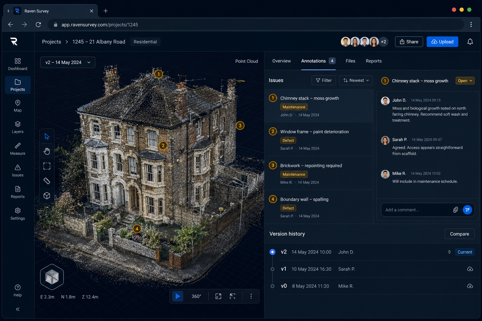
Understanding the technology stack behind modern collaborative survey platforms helps demystify what is actually happening when a client opens a link and sees a fully navigable 3D model of their prospective property.
1. Reality Capture: The Data Foundation
Everything starts on-site. By 2026, reality capture has moved from a niche specialism to mainstream practice across firms of all sizes [3]. The primary tools include:
| Technology | Output | Best Use Case |
|---|---|---|
| Terrestrial Laser Scanning | Dense point clouds (millions of data points) | Structural surveys, heritage buildings |
| Drone Photogrammetry | Ortho-photos, 3D mesh models | Roof surveys, large sites, topography |
| 360° Imaging | Navigable panoramic walkthroughs | Condition reports, snagging, client presentations |
| Mobile LiDAR | Rapid indoor point clouds | Commercial interiors, floor plans |
For clients commissioning a RICS building survey or a structural survey, this means the surveyor arrives on-site with tools that capture far more data, far more accurately, than a tape measure and a notepad ever could.
2. Cloud Upload and Processing
Raw data from the field — which can run to hundreds of gigabytes for a laser scan — is uploaded directly to a cloud processing pipeline, often while the surveyor is still on-site using a mobile connection. Cloud platforms handle the heavy computation: stitching point clouds, generating meshes, building navigable 3D scenes. This process, which once required a powerful desktop workstation and hours of manual work, now runs automatically in the background [2].
3. Browser-Based 3D Visualization
The processed model is published to a web viewer — no specialist software required. Clients and collaborators receive a link. They open it in any modern browser on any device and are immediately inside a fully navigable, photorealistic representation of the property.
Key features of leading platforms in 2026 include:
- 🔍 Measurement tools — click any two points to get an accurate distance
- 📌 Annotation pins — drop a marker on a specific defect with a linked note
- 💬 Comment threads — leave questions or instructions directly on the model
- 🔄 Version history — see exactly what changed between survey visits
- 👥 Multi-user presence — see which collaborators are viewing the model in real time
4. Integrated Communication Channels
Modern platforms do not just display data — they replace the email chain. Surveyors, clients, architects, and engineers communicate within the platform itself, keeping all discussion anchored to the specific element of the survey it relates to. This eliminates the perennial problem of context-free emails ("see attached — the crack I mentioned") and ensures that every decision is traceable [1].
Esri's February 2026 update to ArcGIS Online is a strong indicator of where the broader GIS and mapping industry is heading: the release focused heavily on enhanced web editing, improved 3D scene visualization, and refined cross-organisation content sharing — capabilities that surveyors use to publish interactive property maps and dashboards that multiple parties can edit or comment on in near real time [8].
Digital Twins and the Future of Interactive Property Data

The most significant development in Cloud-Based Platforms for Interactive Property Surveys: Real-Time Collaboration in 2026 is the rise of the property digital twin — a high-fidelity, continuously updated 3D model of a building or land parcel that lives in the cloud and evolves as new data arrives [2].
A digital twin is not just a 3D model. It is a living asset that:
- Integrates data from multiple survey visits over time
- Links to building information (age, materials, planning history)
- Accepts new sensor data (IoT monitors for damp, movement, temperature)
- Supports remote stakeholder exploration and annotation at any time
For a client commissioning a schedule of condition report before signing a commercial lease, a digital twin means the condition of every wall, floor, and roof element is documented in 3D, timestamped, and accessible to their solicitor in real time — not summarised in a 40-page PDF that may be misread or disputed later.
For a developer managing a large site, a digital twin fed by regular drone surveys provides a continuously current picture of progress, accessible to the entire project team without anyone needing to visit the site.
Real-World Applications by Survey Type
Residential Buyers: A client purchasing a Victorian terraced house can receive a browser-based walkthrough of their RICS home survey findings, with defect markers colour-coded by severity and linked to repair cost estimates. Their solicitor and mortgage broker access the same view simultaneously.
Commercial Tenants & Landlords: Parties to a lease can jointly review a dilapidations survey in a shared cloud workspace, annotating disputed items and tracking resolution — replacing weeks of correspondence with a structured, auditable process.
Structural Concerns: When a damp survey or subsidence survey reveals complex issues, the cloud platform allows the surveyor to invite a structural engineer into the workspace to review the same data and add their own annotations before a joint report is issued.
Choosing the Right Cloud Platform: What to Look For in 2026
Not all cloud platforms are equal. The market in 2026 ranges from general-purpose GIS tools (like ArcGIS Online [7]) to purpose-built property survey platforms. When evaluating options, consider the following criteria:
✅ Core Feature Checklist
- Browser-based access — no client-side software installation required
- 3D point cloud and mesh support — handles large reality capture datasets
- Role-based permissions — control what each collaborator can view or edit
- Real-time sync — changes appear instantly for all users
- Offline field capture — surveyors can work without connectivity and sync on return
- Audit trail — every annotation, edit, and comment is timestamped and attributed
- Integration with CAD/BIM — imports and exports standard formats
- GDPR-compliant data storage — critical for UK property data
💰 Cost Considerations
Platform costs vary widely. Some charge per project, others per seat, others by data storage volume. For firms just beginning their digital transition, it is worth reviewing survey pricing structures to understand how cloud delivery affects the overall cost model — both for the firm and for clients who may pay a premium for interactive deliverables.
Security and Compliance
Property survey data is sensitive. It reveals the physical vulnerabilities of a building, its dimensions, and often its occupancy patterns. Reputable platforms offer end-to-end encryption, two-factor authentication, and data residency options that keep UK property data within UK or EU servers.
Real-Time Collaboration in Practice: Cloud-Based Platforms for Interactive Property Surveys in 2026
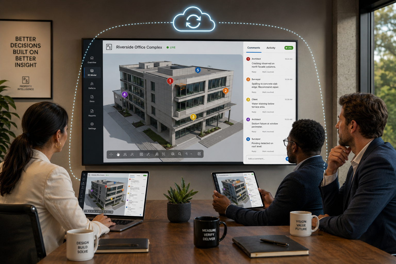
The shift from document delivery to collaborative platform access changes the professional relationship between surveyor and client in meaningful ways.
The Surveyor's New Role
Surveyors are no longer just report writers. They become guides through a digital environment — hosting live walkthrough sessions with clients, annotating findings in real time during a video call, and responding to client queries by pointing directly to the relevant part of the 3D model. This is a richer, more consultative service that commands higher fees and generates stronger client loyalty.
For chartered surveyors, understanding what a property inspection involves remains the professional foundation — cloud platforms amplify and communicate that expertise, they do not replace it.
The Client's New Experience
Clients benefit enormously. Research consistently shows that property buyers and investors struggle to translate written defect descriptions into a mental picture of what is actually wrong with a building [9]. A browser-based 3D model with colour-coded severity markers and photo evidence linked directly to each finding removes that translation problem entirely.
The NAR Realtor Technology Survey confirms that technology tools which improve client communication and transparency are among the highest-rated drivers of client satisfaction in property transactions [10]. Cloud-based interactive surveys deliver precisely that.
Remote Teams and Multi-Disciplinary Projects
For complex projects — a commercial refurbishment, an asbestos survey feeding into a demolition plan, or a roof survey informing an insurance claim — the ability to bring multiple specialists into a single shared workspace without travel or scheduling delays is a genuine competitive advantage.
AI-driven analysis tools, now integrated into leading cloud platforms, can automatically flag anomalies in point cloud data, suggest defect classifications, and even generate draft report sections — reducing the time between site visit and client delivery from days to hours [4].
Barriers to Adoption and How to Overcome Them
Despite the clear benefits, adoption is not universal. Common barriers include:
| Barrier | Practical Solution |
|---|---|
| High upfront software costs | Start with per-project pricing; scale as ROI is proven |
| Staff training requirements | Most platforms offer onboarding programmes; invest in 1–2 champion users |
| Client unfamiliarity with digital tools | Offer a guided walkthrough session; most clients adapt within minutes |
| Data volume and connectivity | Use offline capture apps; upload on return to office |
| Concern about data security | Choose GDPR-compliant, UK-hosted platforms with SOC 2 certification |
The surveying firms that are thriving in 2026 are those that treated digital adoption not as a cost, but as a service differentiator — and communicated that value clearly to clients [3].
Conclusion: Actionable Next Steps for Property Professionals
The transition to Cloud-Based Platforms for Interactive Property Surveys: Real-Time Collaboration in 2026 is not a distant prospect — it is the current competitive baseline for firms that want to win and retain clients in a market where instant, interactive, and collaborative delivery is the expectation.
Here are the most important actions to take right now:
- Audit your current delivery model. Are you still sending static PDFs? Map the gap between what you deliver and what leading platforms offer.
- Pilot one project with a cloud platform. Choose a straightforward survey type — a snagging report or a schedule of condition — and deliver it interactively. Gather client feedback.
- Invest in reality capture hardware. Even an entry-level 360° camera dramatically improves the richness of a cloud-based deliverable.
- Train your team on collaboration workflows. The technology is only as good as the process built around it.
- Communicate the upgrade to clients. Make interactive delivery a visible part of your service proposition — not a hidden back-end process.
- Review your pricing. Interactive, cloud-based deliverables justify a premium. Ensure your fee structure reflects the added value.
The firms that embrace this shift are not just delivering better surveys — they are building stronger client relationships, reducing rework, and positioning themselves as the professionals of choice in an increasingly digital property market.
References
[1] Cloud Based Platforms Enabling Real Time Collaboration In Property Surveys – https://www.canterburysurveyors.com/blog/cloud-based-platforms-enabling-real-time-collaboration-in-property-surveys/
[2] Future Land Surveying 2026 – https://haller-blanchard.com/future-land-surveying-2026/
[3] Doubling Down On Digital – https://amerisurv.com/2026/02/01/doubling-down-on-digital/
[4] AI Driven Precision In Land Surveying How Artificial Intelligence Is Transforming Data Collection And Analysis – https://nottinghillsurveyors.com/blog/ai-driven-precision-in-land-surveying-how-artificial-intelligence-is-transforming-data-collection-and-analysis
[5] AI And Satellite Based Surveying How 63 Of Companies Are Transforming Land Analysis – https://wimbledonsurveyors.com/ai-and-satellite-based-surveying-how-63-of-companies-are-transforming-land-analysis/
[6] Digital Trends Operations Survey – https://www.pwc.com/us/en/services/consulting/supply-chain-operations/library/digital-trends-operations-survey.html
[7] ArcGIS – https://www.arcgis.com
[8] What's New In ArcGIS Online February 2026 – https://www.esri.com/arcgis-blog/products/arcgis-online/announcements/whats-new-in-arcgis-online-february-2026
[9] Technologies To Use In Real Estate Development Trends – https://inoxoft.com/blog/technologies-to-use-in-real-estate-development-trends/
[10] Realtor Technology Survey – https://www.nar.realtor/research-and-statistics/research-reports/realtor-technology-survey