{"cover":"Professional landscape format (1536×1024) hero image with bold text overlay 'Building Survey Evidence in Boundary' in crisp white sans-serif on a deep navy semi-transparent overlay panel, centered with 8% safe margins from every edge, two balanced lines, no character near the edge. Background: editorial daylight photograph of a professional surveyor in a high-visibility vest holding a digital tablet and laser measuring device, standing beside a brick boundary wall with visible crack damage, shallow depth of field, clean morning light, authoritative documentary aesthetic, navy and slate-grey palette with warm brick tones.","content":["Numbered step-by-step process flow diagram, landscape format 1536×1024, clean white background with teal and charcoal palette. Five sequentially numbered stages shown left to right with connecting arrows: Stage 1 labeled 'Pre-Works Notice', Stage 2 labeled 'Site Inspection', Stage 3 labeled 'Photographic Log', Stage 4 labeled 'Schedule of Condition', Stage 5 labeled 'Award / Report'. Each stage has a small icon above it and 3 short bullet labels below naming key actions. Callout lines point to a central annotated example schedule document. Editorial infographic style, crisp typography, professional surveying theme, no pricing or checkmark grids.","Annotated documentary photography, landscape format 1536×1024, showing a close-up split-screen: left panel depicts a surveyor's hands photographing a cracked plaster wall with a timestamp-visible DSLR camera, with callout labels reading 'Time-stamped Image', 'Crack Width Measurement', and 'Reference Scale Bar'. Right panel shows the same crack documented on a printed schedule of condition form with callout labels 'Baseline Condition', 'Pre-existing Defect Note', and 'Surveyor Signature Block'. Warm natural interior lighting on left, clean studio lighting on right. Teal and warm-amber editorial palette, magazine-quality composition, no prices or number grids.","Isometric illustration, landscape format 1536×1024, depicting a boundary dispute scenario viewed from above at a 45-degree angle. Shows two adjacent residential properties separated by a boundary line with measurement markers. Left property has a surveyor figure (South Asian woman, mid-30s) using a total station instrument. Right property shows a party wall with annotated damage zones. Callout labels include 'Measured Survey Line', 'Title Plan Overlay', 'Photographic Evidence Zone', 'Movement Monitor Point', and 'Award Documentation'. Deep navy and teal colour scheme with bright accent lines marking the boundary, crisp vector-illustration style, professional and authoritative."]
Nearly a third of all Party Wall Act disputes escalate beyond the initial award stage, often because the underlying survey evidence is incomplete, poorly sequenced, or fails to establish a credible baseline. For surveyors acting in these matters, the quality of documentation is not a secondary concern, it is the foundation on which every award, negotiation, and court claim rests. This practical playbook covers the full evidence lifecycle for building survey evidence in boundary and party wall disputes: how surveyors document damage and risk, from the first site visit through to the final report.
Key Takeaways
- A Schedule of Condition prepared before works begin is the single most important piece of evidence in any party wall damage claim.
- Time-stamped photographic records tied directly to the Schedule of Condition are now the standard expected by both RICS guidance and the courts.
- Surveyors must clearly separate their quasi-judicial role from design and supervision responsibilities to preserve the integrity of their evidence.
- Boundary disputes require measured surveys, title plan analysis, and multi-source evidence, no single document is sufficient on its own.
- Digital tools and structured inspection methodologies are raising the evidentiary bar; surveyors who rely on informal notes risk having their evidence challenged or disregarded.
The Role of the Schedule of Condition in Party Wall Disputes
The Schedule of Condition has become the cornerstone of building survey evidence in boundary and party wall disputes. It functions as a "before" snapshot, a formal, structured record of the adjoining owner's property taken before any notifiable works begin. Without it, attributing post-works damage to the building owner's activities becomes an exercise in speculation rather than evidence [1].
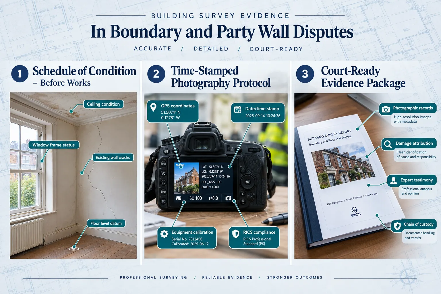
A well-prepared Schedule of Condition should include:
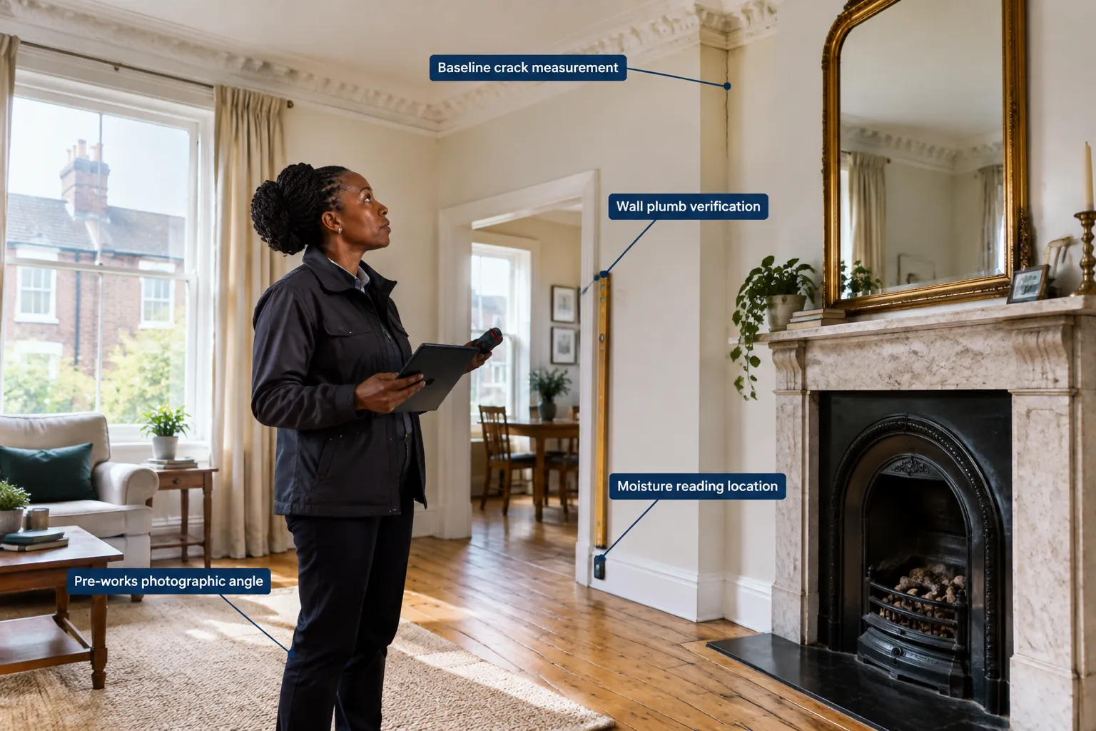
- Room-by-room written descriptions of existing defects, cracks, settlement patterns, and surface finishes
- Time-stamped photographic evidence cross-referenced to each written entry
- Crack width measurements recorded with a calibrated gauge and documented with a scale bar in the photograph
- Reference markers placed at key locations to enable accurate comparison after works
The document must be signed and dated by the surveyor and, ideally, acknowledged by both parties before works commence [7]. RICS guidance reinforces that the schedule should be proportionate to the scope and risk of the proposed works, a simple loft conversion warrants a different level of detail than deep basement excavation [6].
"The schedule is not merely a formality. It is the evidential anchor against which all post-works damage assessments are measured."
One common error is treating the schedule as a photographic album rather than a structured legal document. Each entry should describe the defect's location, extent, and probable cause. Pre-existing defects must be explicitly identified and described in detail; failure to do so can result in a building owner being held liable for damage that predated their works [3].
Timing and Access
The schedule must be completed before works begin, not during, and certainly not after a dispute has arisen. Where access is refused by the adjoining owner, the surveyor should document the refusal in writing and note the limitation clearly in the award. Courts have taken a dim view of schedules prepared retrospectively, and recent case law up to mid-2026 has reinforced that jurisdiction under the Party Wall etc. Act 1996 is closely tied to procedural compliance [5].
Photographic Evidence, Movement Monitoring, and Digital Documentation
The shift toward digital documentation has fundamentally changed how building survey evidence in boundary and party wall disputes is assembled and presented. Time-stamped photography is no longer a best practice, it is the baseline expectation [10].
Photographic Standards
Every photograph taken as part of a party wall or boundary survey should meet the following minimum standards:
| Requirement | Detail |
|---|---|
| Timestamp | Camera or device clock set to correct date and time; metadata preserved |
| Scale reference | Ruler, coin, or calibrated scale bar visible in crack or defect shots |
| Location reference | Wide-angle context shot followed by close-up detail shot |
| Cross-referencing | Each photograph numbered and linked to the corresponding schedule entry |
| Storage | Backed up to a secure, time-stamped digital archive immediately after the survey |
Photographs without scale references or location context have limited evidential value. A crack that appears dramatic in isolation may be trivial in context, or vice versa. Surveyors should always take both an establishing shot and a close-up for every recorded defect [1].
Movement Monitoring
For higher-risk works, deep excavations, underpinning, or demolition adjacent to a shared wall, passive photographic records are insufficient. Surveyors should specify and oversee the installation of:
- Tell-tales or crack monitors fixed across existing cracks, with baseline readings recorded before works begin
- Precise level surveys of floors and thresholds at defined intervals during the construction programme
- Vibration monitoring where piling or heavy plant is involved
Movement data must be logged with dates, times, and the name of the person recording each reading. Where automated monitoring equipment is used, the calibration records should be retained as part of the evidence file. Any movement that exceeds pre-agreed trigger levels should prompt an immediate inspection and a written note to all parties [10].
Digital Tools and Their Limitations
Structured data capture apps, laser measuring devices, and cloud-based condition survey platforms have improved the speed and consistency of party wall documentation. However, surveyors should be cautious about over-reliance on automated or AI-assisted workflows. There is growing professional concern that AI tools used in notices and evidence workflows may introduce errors or omissions that are difficult to detect and defend under cross-examination. Any digital output must be reviewed, verified, and signed off by the responsible surveyor before it forms part of the formal record [2].
Boundary Dispute Evidence: Measured Surveys, Title Plans, and Multi-Source Analysis
Boundary disputes present a distinct evidential challenge. Unlike party wall damage claims, where the question is typically "did these works cause this damage?", boundary disputes often turn on questions of historical fact, legal interpretation, and physical measurement. Building survey evidence in boundary and party wall disputes involving boundaries must therefore draw on multiple, independently verifiable sources [8].

The Measured Survey
A measured boundary survey is the starting point for any serious boundary dispute. It should be carried out by a suitably qualified surveyor using calibrated equipment, typically a total station or GPS device, and the results plotted to scale. The survey should record:
- The physical features on the ground: walls, fences, hedges, ditches, and their precise dimensions and positions
- The relationship between physical features and the paper title: how the physical boundary compares to the title plan at HM Land Registry
- Any discrepancies: areas where the physical occupation differs from the legal boundary shown on the title
HM Land Registry's 2026 guidance has embedded clearer evidential standards for boundary documentation submitted in connection with dispute applications. Surveyors preparing evidence for Land Registry proceedings should ensure their measured surveys are accompanied by a written report explaining the methodology, the equipment used, and the surveyor's professional conclusions [9].
Title Plan Analysis
Title plans prepared by HM Land Registry are drawn to a general boundary rule, they do not show the precise legal boundary. This is a point of frequent confusion for property owners and, occasionally, for less experienced practitioners. The general boundary shown on a title plan is a starting point, not a definitive answer.
Surveyors should supplement title plan analysis with:
- Historical Ordnance Survey maps showing the boundary's position over time
- Conveyance plans and deeds from the original sale or subdivision of the land
- Photographic evidence of historical boundary features, including old photographs, aerial images, and Google Street View archives
- Witness evidence from long-standing neighbours, where available and relevant
No single source is conclusive. The strength of a boundary case depends on the convergence of multiple independent lines of evidence pointing to the same conclusion [4].
Documenting Encroachments and Risk
Where an encroachment is alleged, a wall, fence, or structure built across the boundary, the surveyor's report must document:
- The precise location of the encroachment relative to the legal boundary
- The dimensions and nature of the encroaching structure
- When the encroachment is believed to have occurred, with supporting evidence
- Any adverse possession considerations, particularly where the encroachment has been in place for an extended period
Risk documentation in boundary disputes should also address the potential consequences of the disputed boundary position: access rights, drainage, overlooking, and the impact on the value or use of both properties.
Surveyors' Quasi-Judicial Role and the Integrity of Evidence
One of the most important, and most frequently misunderstood, aspects of party wall practice is the surveyor's quasi-judicial role. When appointed under the Party Wall etc. Act 1996, a surveyor is not acting as an advocate for the party who appointed them. They are performing a statutory function, and their award must be impartial and evidence-based [4].
This distinction has direct implications for how evidence is gathered and presented:
- The appointed surveyor must not allow their evidence to be shaped by the appointing party's preferred outcome. Schedules of condition, damage assessments, and risk reports must reflect what the surveyor actually found, not what either party wants to have found.
- The surveyor's jurisdiction is defined by the notice. Recent case law has reinforced that surveyors acting without a valid notice have no jurisdiction, and any award made in those circumstances may be void [5]. This means the evidence trail must begin with a properly served notice.
- Design and supervision are separate functions. A surveyor who has designed the works or supervised the contractor is in a conflicted position if they also attempt to act as the impartial party wall surveyor. These roles must be kept distinct to preserve the integrity of the evidence and the award [8].
Documenting Limitations and Pre-Existing Defects
Risk management in party wall practice now centres on explicit, transparent documentation of the surveyor's limitations. Every schedule of condition and damage report should include:
- A clear statement of the areas inspected and, critically, any areas that were not inspected (and why)
- A record of any access restrictions encountered during the survey
- An explicit list of pre-existing defects that are not attributable to the notifiable works
- A statement of the surveyor's qualifications and the basis on which their opinion is given
Failure to document limitations creates a vulnerability: if a dispute later arises about damage in an area that was not inspected, the surveyor's evidence may be challenged on the basis that the omission was negligent rather than disclosed [3].
How Survey Evidence Feeds Into Awards and Court Claims
The practical purpose of all this documentation is to support a resolution, whether through a party wall award, a negotiated settlement, or court proceedings. Understanding how evidence is used at each stage helps surveyors structure their records appropriately from the outset.
The Party Wall Award
A party wall award is the formal document that resolves a dispute under the Act. It must be grounded in the surveyors' evidence and should address:
- The works permitted and any conditions attached
- The schedule of condition, incorporated by reference or as an appendix
- Any compensation payable for damage caused by the works
- The rights of access and the obligations of the building owner during construction [9]
Where damage has occurred, the award should specify the nature of the damage, the evidence relied upon to attribute it to the notifiable works, and the remediation required or the compensation agreed. Vague awards that refer to "any damage caused" without specifying the evidence base are increasingly being challenged [10].
Court Claims and Expert Evidence
Where a dispute cannot be resolved by the surveyors, it may proceed to the County Court. In that context, the surveyor's documentation becomes expert evidence subject to the Civil Procedure Rules. Key requirements include:
- The expert's report must be addressed to the court, not to the instructing party
- It must set out the facts on which the opinion is based, the methodology used, and any limitations
- Photographs, survey data, and monitoring records must be exhibited and clearly cross-referenced
Surveyors who have maintained a rigorous, contemporaneous evidence trail from the outset are significantly better placed in court proceedings than those who have relied on informal records or retrospective reconstruction.
Conclusion
The evidential standards expected of surveyors acting in boundary and party wall disputes have risen sharply in 2026, driven by updated RICS guidance, tightened HM Land Registry requirements, and a body of case law that rewards precision and penalises procedural shortcuts. The core message is straightforward: documentation is not administrative overhead, it is the substance of the surveyor's professional contribution.
Actionable next steps for surveyors:
- Prepare the Schedule of Condition before any works begin, treat it as a legal document, not a site note.
- Establish a photographic protocol that includes timestamps, scale references, location context shots, and a numbered cross-reference system.
- Specify movement monitoring proportionate to the risk of the works, and retain all calibration and reading records.
- Keep the quasi-judicial role clearly separate from any design or supervision function on the same project.
- Document all limitations and pre-existing defects explicitly, undisclosed gaps in the inspection are a professional liability risk.
- Structure reports so they can be used directly in an award or court proceedings, clarity, cross-referencing, and a stated methodology are non-negotiable.
Surveyors who build these habits into every instruction, regardless of the apparent complexity of the case, will produce evidence that withstands scrutiny, supports fair outcomes, and protects their professional standing.
References
[1] Schedule Of Condition Report Party Wall Awards – howorth.uk
[2] News – whmatthews.com
[3] How To Make A Party Wall Damage Claim 2026 Guide – christopheranthony.org.uk
[4] Party Wall Etc Act 1996 – trowers.com
[5] Party Wall Etc Act 1996 Surveyors Beware No Notice No Jurisdiction – wardhadaway.com
[6] Party Walls – rics.org
[7] Party Wall Schedule Of Condition – onlinearchitecturalservices.com
[8] Party Wall Surveyors Ongoing Jurisdiction – bandsc.co.uk
[9] Navigating The Party Wall Act Retrospective Awards And Surveyors Role In Settling Disputes – tayross.com
[10] Party Wall Act Dealing With Damage – bandsc.co.uk