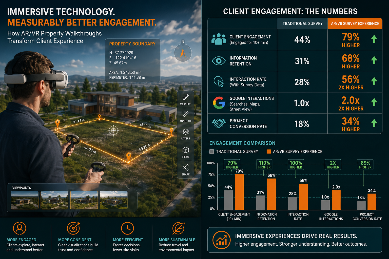
Three-dimensional immersive technology now engages property decision-makers up to 79% more effectively than traditional presentation methods alone [10]. That single statistic explains why the surveying profession in 2026 is undergoing one of its most significant shifts in decades. The integration of virtual tours and AR/VR in property boundary surveys is enhancing client engagement at every stage of the process — from initial instruction through to final dispute resolution — and chartered surveyors who ignore this shift risk falling behind a rapidly evolving proptech landscape.
Key Takeaways
- AR and VR technology allows clients to explore accurate boundary overlays in immersive, real-time virtual environments, dramatically improving remote assessments.
- Virtual tours powered by LiDAR scanning and Matterport-style platforms deliver dimensionally accurate representations of property boundaries that reduce disputes.
- Client engagement metrics for properties using 3D virtual tours show up to 2x more interaction compared to static presentations.
- AR/VR avatars can guide clients through complex boundary data in plain language, making technical survey findings more accessible.
- In 2026, proptech adoption is accelerating across the UK surveying sector, with boundary surveys among the most impacted service areas.
How AR/VR Is Transforming Property Boundary Surveys
Traditional boundary surveys have always demanded a high level of technical literacy from clients. Reading OS maps, interpreting title plan red-line boundaries, and understanding the difference between a legal boundary and a physical feature requires expertise most property owners simply do not have. This knowledge gap has historically led to misunderstandings, delayed decisions, and costly disputes.
Augmented reality and virtual reality are closing that gap. By overlaying precise boundary data onto immersive three-dimensional environments, these technologies translate complex legal and spatial information into something a client can see, walk through, and immediately understand.
What the Technology Actually Does
At its core, AR/VR in boundary surveying works by combining several data streams:
- LiDAR point cloud scanning — captures millimetre-accurate spatial data of a property and its surroundings
- 360-degree photographic capture — creates photorealistic environments for virtual walkthroughs
- GIS and title register data — supplies the legal boundary coordinates
- AR overlay engines — projects boundary lines, measurements, and annotations onto the virtual environment in real time
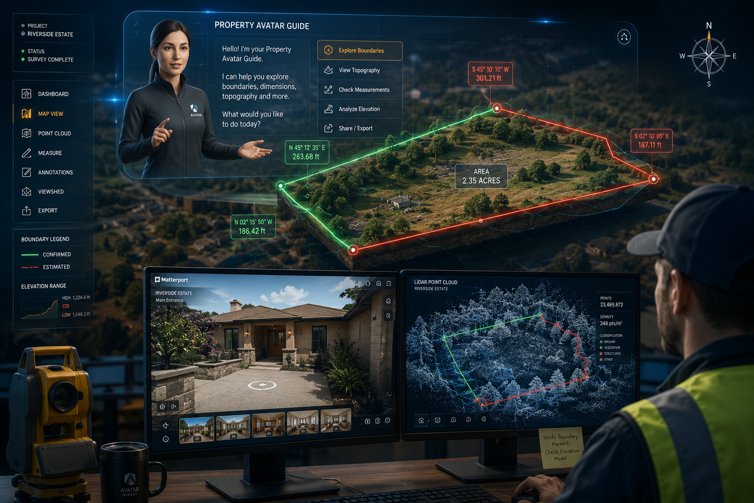
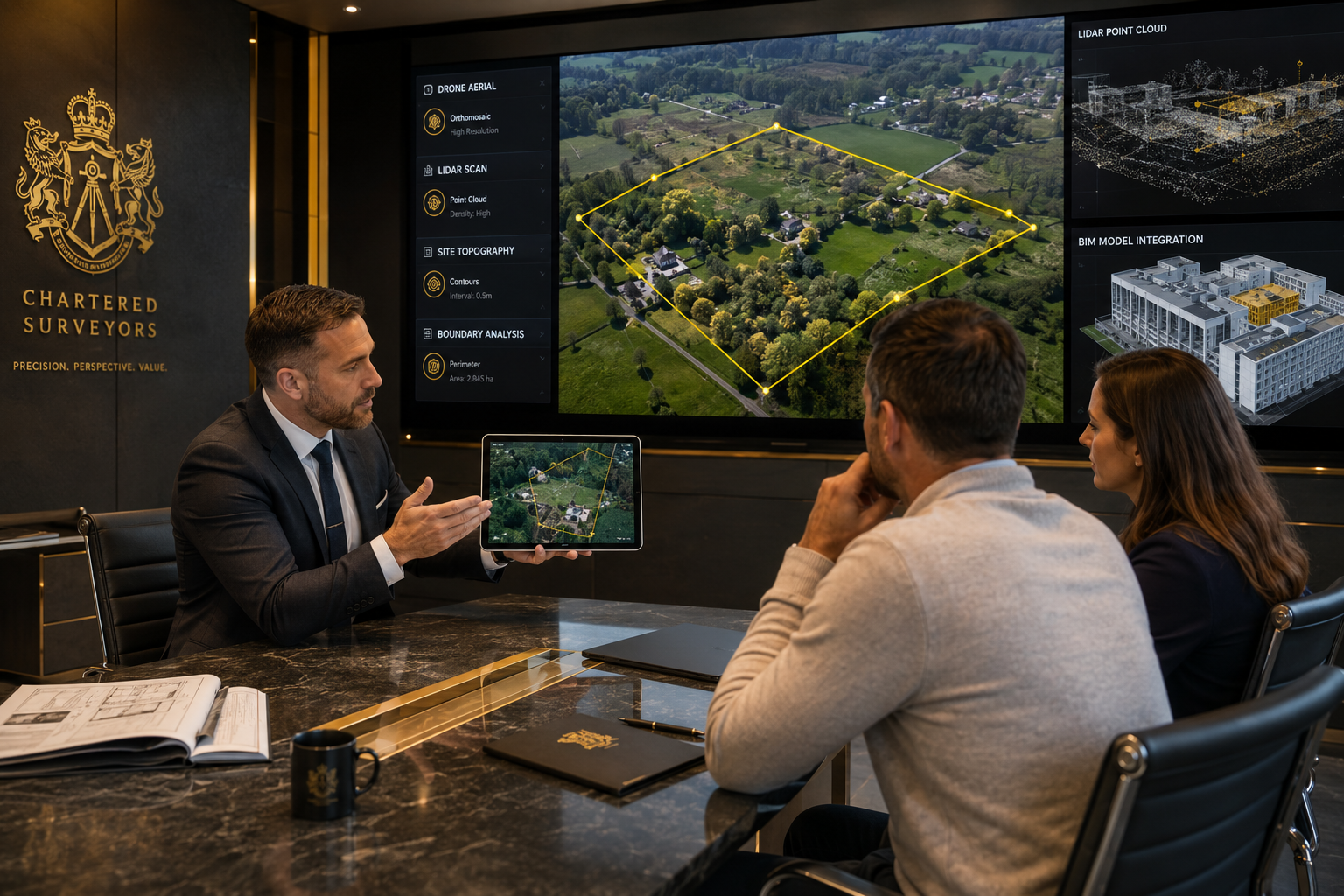
Platforms like Matterport and similar tools used by firms such as Asbuilt Conditions and We R Survey transform raw scan data into navigable 3D models [8][9]. When a surveyor layers legal boundary data onto these models, a client can literally stand inside a virtual version of their property and see exactly where their legal boundary runs — including any discrepancies between the legal line and the physical fence, wall, or hedge.
"The ability to walk a client through their boundary dispute in a virtual environment — showing them precisely where the encroachment sits — reduces misunderstanding and accelerates resolution."
This is not a minor convenience. Boundary disputes are among the most emotionally charged and financially damaging situations a property owner can face. Anything that brings clarity earlier in the process has real value.
The Role of AR/VR Avatars in Guiding Virtual Property Tours With Boundary Overlays
One of the most significant developments in 2026 proptech is the use of AI-driven AR/VR avatars as virtual guides within property tours. Rather than leaving clients to navigate complex boundary data alone, these digital guides walk them through the findings in plain language, pointing to relevant features and explaining their significance.
How Avatar-Guided Tours Work in Practice
Consider a scenario where a client has instructed a chartered surveyor to investigate a boundary dispute with a neighbouring property. Historically, the surveyor would produce a written report with attached plans — documents that require considerable expertise to interpret.
With avatar-guided AR/VR tours, the process changes substantially:
- The surveyor conducts the physical site inspection and captures LiDAR and 360-degree data.
- The data is processed into a navigable 3D model with legal boundary lines overlaid.
- An AI avatar is configured to guide the client through the virtual environment, narrating key findings at each point.
- The client accesses the tour via a VR headset, tablet, or standard web browser — from any location.
- The client can pause, ask questions (via integrated chat or voice), and revisit sections as many times as needed.
VSN Interactive and similar platforms already offer 1:1 scale property experiences accessible anytime and anywhere, which is particularly valuable for clients who cannot attend a physical site visit [3]. CAVR's virtual showroom technology accurately represents property dimensions and qualities, enabling clients to make critical decisions remotely [6].
Improving Remote Assessments and Sales
The remote assessment capability is transformative for several property survey types beyond boundary work. For example:
| Survey Type | Traditional Client Experience | AR/VR Enhanced Experience |
|---|---|---|
| Boundary dispute | Written report with 2D plans | Immersive 3D walkthrough with boundary overlays |
| Pre-purchase survey | PDF report with photographs | Interactive virtual tour linked to defect annotations |
| Drone survey | Video footage and stills | Georeferenced 3D model with measurement tools |
| Structural assessment | Written schedule with photos | Annotated 3D model highlighting structural elements |
The commercial case is equally compelling. TrueDepth Imaging reports that 3D virtual tours generate up to 2x more engagement on Google compared to standard listings, increase client confidence before arrival, and reduce wasted appointments [see source research]. For drone surveys in particular, combining aerial footage with AR boundary overlays gives clients a perspective that no ground-level inspection can replicate.
Practical Implementation: Enhancing Client Engagement Through Virtual Tours and AR/VR in Property Boundary Surveys
Moving from concept to practice requires surveyors to make deliberate choices about technology, workflow, and client communication. The good news is that the barrier to entry has fallen considerably in 2026, with several platforms offering accessible, scalable solutions.
Choosing the Right Platform
Not all virtual tour platforms are equal when it comes to boundary survey applications. The key criteria for selection include:
- Dimensional accuracy — the platform must support LiDAR or structured-light scanning to produce survey-grade models
- Annotation and overlay capability — the ability to add boundary lines, measurements, and legal reference points
- Accessibility — clients should be able to access the tour without specialist hardware; browser-based access is essential
- Integration with CAD/BIM workflows — for seamless data transfer between survey software and the virtual environment
We R Survey, for instance, offers industry-leading 3D laser scanning combined with Matterport virtual tours and CAD/BIM services, trusted by major organisations to transform spaces into actionable digital assets [9]. Real Space similarly provides a full suite including 3D layouts, virtual walkthroughs, aerial drone footage, and floor plans using Matterport technology [7].
Workflow Integration for Boundary Surveyors
A practical implementation workflow for a boundary survey firm might look like this:
Step 1 — Site data capture
Use LiDAR scanning or photogrammetry to capture the site. This data forms the foundation of the virtual model.
Step 2 — Model processing
Process raw scan data into a navigable 3D environment. Most platforms automate much of this step.
Step 3 — Boundary data overlay
Import legal boundary coordinates from the title register and overlay them onto the 3D model. Highlight discrepancies between legal and physical boundaries.
Step 4 — Annotation and narration
Add text annotations, measurement callouts, and — where avatar guidance is used — configure the AI guide's narration script.
Step 5 — Client delivery
Share a secure link with the client. Provide a brief orientation guide. Schedule a follow-up call to discuss findings.
Step 6 — Report integration
Reference the virtual tour within the formal survey report, allowing clients to cross-reference written findings with the immersive model.
This workflow is compatible with a range of survey types handled by professional firms, including structural surveys, subsidence surveys, and expert witness reports where visual evidence presentation is critical.
Addressing Common Client Concerns
"I don't have a VR headset."
Most modern platforms are fully functional via a standard smartphone or desktop browser. VR headsets enhance the experience but are not required.
"How accurate are the boundary lines shown?"
When sourced from official title register data and processed by a qualified surveyor, the overlays carry the same accuracy as the underlying legal data. The virtual environment does not alter the data — it visualises it.
"Is my data secure?"
Reputable platforms offer password-protected tours with access controls. Surveyors should confirm data handling practices with their chosen provider and ensure GDPR compliance.
The Impact on Party Wall and Dispute Cases
Virtual tours and AR/VR technology are particularly valuable in contentious situations. In party wall matters, for example, being able to show both parties exactly where a proposed excavation or construction sits in relation to the shared boundary — in an immersive, undeniable visual format — can de-escalate disputes before they reach formal proceedings.
CloudPano's AR/VR approach to complex site communication demonstrates this principle: combining AR and VR with 360-degree tours enhances communication with clients, contractors, and insurers, facilitating better understanding and faster approvals [2]. The same logic applies directly to boundary and party wall cases.
For surveyors dealing with property damage in party wall situations, a virtual tour that documents pre-existing conditions with millimetre accuracy provides an evidence base that is far more compelling — and harder to dispute — than a written schedule with photographs.
Challenges and Considerations for 2026 Adoption
Despite the clear benefits, there are genuine challenges that surveying firms must navigate when adopting AR/VR for boundary work.
Cost and Return on Investment
High-quality LiDAR scanning equipment and software licences represent a meaningful upfront investment. However, the cost of entry has dropped significantly, and many firms are finding that the efficiency gains — fewer client queries, faster dispute resolution, reduced need for repeat site visits — justify the expenditure within a relatively short period.
Professional Standards and Legal Admissibility
In the UK, any boundary survey evidence presented in legal proceedings must meet standards set by the courts and professional bodies including RICS. Virtual tour models are admissible as supporting evidence, but they must be produced by a qualified surveyor and accompanied by a formal written report. The visual tool enhances the report; it does not replace it.
Skills and Training
Adopting new technology requires investment in training. Surveyors need to understand not only how to operate scanning hardware and software but also how to interpret and present the data responsibly. Professional development in this area is increasingly available through RICS and specialist proptech training providers.
Accessibility for All Clients
While most clients can access browser-based tours easily, some — particularly older clients or those with limited digital literacy — may need additional support. Firms should always offer a traditional report alongside any virtual tour, and be prepared to walk clients through the virtual environment during a video call if needed.
Conclusion
The convergence of virtual tours and AR/VR in property boundary surveys is enhancing client engagement in ways that were impractical just a few years ago. In 2026, the technology is mature enough to deploy at scale, affordable enough for firms of all sizes, and compelling enough that clients are beginning to expect it.
Actionable next steps for surveying firms:
- Audit your current client communication tools. Identify where boundary data is most frequently misunderstood and where a virtual tour would add the most clarity.
- Pilot a LiDAR-based virtual tour on a boundary dispute case. Measure client satisfaction and resolution speed against your baseline.
- Evaluate platform options based on dimensional accuracy, browser accessibility, and CAD/BIM integration.
- Train your team — both in operating the technology and in presenting virtual tour findings to clients professionally.
- Update your report templates to reference virtual tour links as supplementary evidence, ensuring compliance with RICS standards.
- Communicate the capability to clients proactively — many clients do not know this service exists, and awareness itself is a differentiator.
The firms that move decisively now will build a client experience advantage that is difficult for slower adopters to close. For clients navigating the stress of boundary disputes, pre-purchase uncertainty, or complex structural assessments, the ability to see and understand their property in immersive detail is not a luxury — it is a genuine service improvement that builds trust and drives better outcomes.
References
[1] vpt-platform – https://vpt-platform.com/?utm_source=openai
[2] Property Restoration Ar Vr Virtual Tours – https://www.cloudpano.com/restoration/property-restoration-ar-vr-virtual-tours?utm_source=openai
[3] vsninteractive – https://www.vsninteractive.com/?utm_source=openai
[4] Ar Vr Architectural Experience – https://www.arcnsphere.com/ar-vr-architectural-experience?utm_source=openai
[5] pix-virtual – https://www.pix-virtual.com/?utm_source=openai
[6] Virtual Tours – https://cavr.ca/real-estate-vr-ar-solutions/virtual-tours/?utm_source=openai
[7] realspacegr – https://www.realspacegr.com/?utm_source=openai
[8] asbuiltconditions – https://www.asbuiltconditions.com/?utm_source=openai
[9] wercrm.wersurvey – https://wercrm.wersurvey.com/?utm_source=openai
[10] ventra7 – https://ventra7.io/?utm_source=openai