Global food demand is expected to increase by 50% before 2050, yet the amount of arable land available is shrinking. That pressure has pushed agriculture into a technological revolution — and at the centre of that revolution stands a profession most people associate with buildings and boundaries: the chartered surveyor.
Precision farming — the practice of using real-time data to manage crops, soil, and resources at a highly granular level — depends entirely on accurate spatial information. That is exactly what professional surveyors deliver. Through the combined power of unmanned aerial vehicles (UAVs) and Geographic Information System (GIS) data, surveyors are now enabling farmers to make smarter decisions, reduce waste, and increase yields. This article explores how Precision Farming: How Surveyors Enable Agriculture with UAVs and GIS Data works in practice, why affordable 2026 drone technology has been a game-changer, and what farmers and landowners can do to take advantage of these capabilities.
Key Takeaways
- Precision farming uses UAV-captured imagery and GIS data to manage crops at a field-by-field, even plant-by-plant, level.
- Chartered surveyors bring the spatial accuracy, data interpretation skills, and regulatory knowledge that precision agriculture demands.
- Affordable drone hardware in 2026 has made high-resolution aerial surveys accessible to farms of all sizes.
- GIS mapping enables targeted interventions — reducing fertiliser, water, and pesticide use while improving yields.
- Surveyors also play a critical role in land boundary verification, drainage planning, and long-term land management strategy.
What Is Precision Farming and Why Does It Need Surveyors
Precision farming — also called precision agriculture — is a management approach that uses location-specific data to optimise every input applied to a field. Instead of treating an entire farm uniformly, farmers apply the right amount of water, fertiliser, or pesticide to exactly the right place at exactly the right time.
This sounds straightforward, but it requires a foundation of highly accurate geospatial data. Soil composition varies across a single field. Drainage patterns create wet and dry zones. Elevation changes affect frost risk and runoff. Without precise mapping of these variables, targeted interventions are impossible.
This is where surveyors become indispensable. A chartered surveyor brings a structured, standards-based approach to data collection and spatial analysis. Their training in measurement accuracy, coordinate systems, and data validation ensures that the maps underpinning precision agriculture decisions are reliable enough to act on.
The Core Data Layers in Precision Agriculture
| Data Layer | What It Measures | Surveying Method |
|---|---|---|
| NDVI (Vegetation Index) | Crop health and vigour | UAV multispectral imaging |
| Digital Elevation Model | Terrain and drainage | LiDAR or photogrammetry |
| Soil Variability Map | Nutrient and moisture zones | Ground sensors + GIS integration |
| Boundary and Parcel Data | Legal land extents | GPS/GNSS survey |
| Yield History Maps | Past productivity patterns | GPS-linked harvester data |
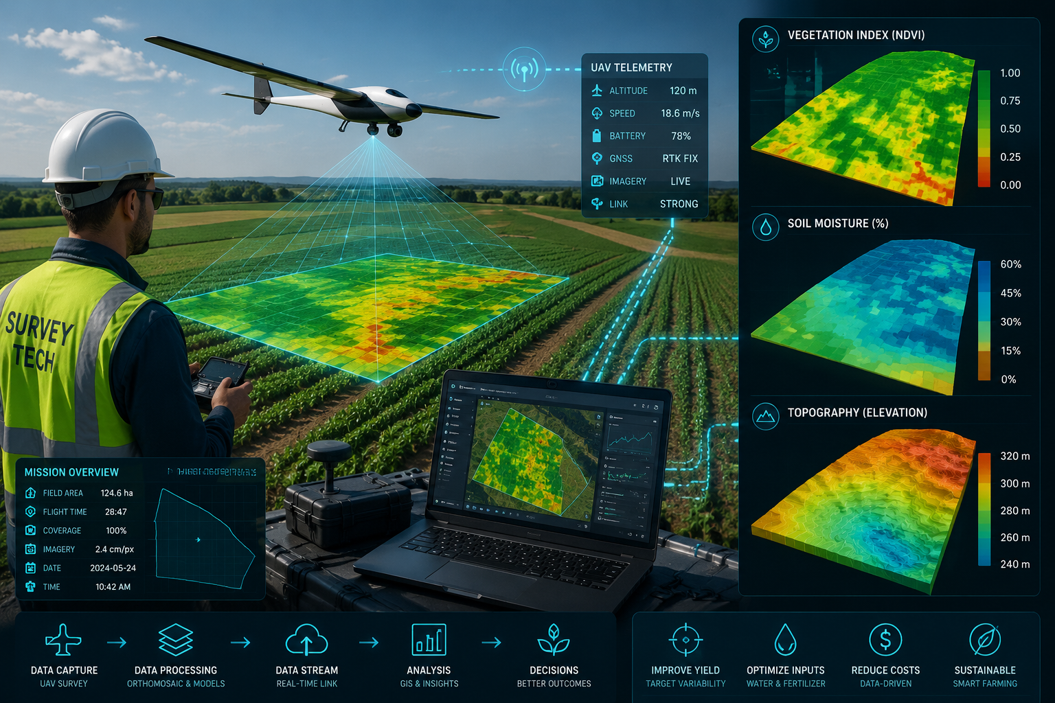
Each of these layers is georeferenced — meaning every data point is tied to a precise location on the Earth's surface. Surveyors manage this georeferencing process, ensuring that data from different sources can be overlaid accurately in a GIS platform.
How UAV Technology Powers Precision Farming: How Surveyors Enable Agriculture with UAVs and GIS Data
The cost of capable agricultural drones has dropped dramatically. In 2026, a professional-grade multispectral UAV capable of surveying 200 hectares in a single flight can be acquired for a fraction of what similar equipment cost five years ago. This affordability has opened precision agriculture to mid-size and smaller farms that previously could not justify the investment.
Surveyors deploy UAVs in several key ways on agricultural land:
Multispectral and Thermal Imaging
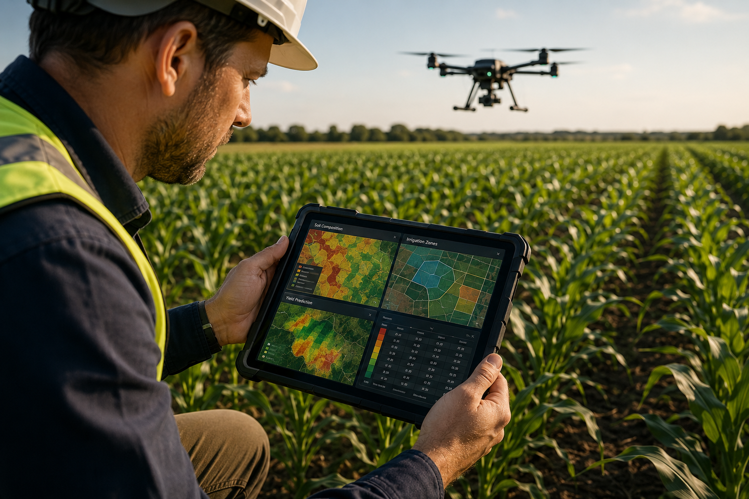
Standard RGB cameras capture what the human eye sees. Multispectral cameras capture light beyond the visible spectrum — particularly near-infrared wavelengths that reveal plant stress long before it becomes visible. A stressed crop absorbs and reflects light differently than a healthy one.
By processing multispectral imagery, surveyors generate Normalised Difference Vegetation Index (NDVI) maps. These colour-coded maps show, at centimetre-level resolution, which parts of a field are thriving and which are struggling. Farmers can then direct irrigation, fertiliser, or pest control precisely where it is needed — rather than applying it uniformly across an entire field.
Thermal imaging adds another dimension: it detects temperature variations that indicate irrigation problems, drainage failures, or disease hotspots.
Photogrammetric Mapping and 3D Modelling
UAVs equipped with high-resolution cameras and GPS receivers can generate orthomosaic maps — geometrically corrected aerial images that function like accurate maps rather than simple photographs. From overlapping drone images, surveyors produce:
- Digital Surface Models (DSMs): showing the height of everything above ground, including crop canopy
- Digital Terrain Models (DTMs): showing bare earth elevation after vegetation is removed
- Contour maps: identifying water flow paths and drainage risk zones
These outputs feed directly into farm management software and GIS platforms. The same photogrammetric principles used in boundary surveys for property demarcation apply here — accuracy and georeferencing are non-negotiable.
Real-Time Kinematic (RTK) GPS Integration
Modern agricultural UAVs often incorporate RTK GPS, which corrects positional errors in real time using a ground-based reference station. This reduces positional error from several metres down to 1-2 centimetres. For precision agriculture, that level of accuracy means variable-rate application equipment can respond to GIS prescription maps with pinpoint precision.
"The surveyor's role in precision agriculture is not simply to fly a drone — it is to guarantee that every data point collected is accurate enough to make a financial and agronomic decision on."
GIS Data: Turning Raw Surveys into Actionable Farm Intelligence
Collecting data is only half the task. The real value of precision farming lies in what happens when that data is processed, layered, and analysed within a GIS platform.
GIS software allows surveyors and agronomists to overlay multiple data layers simultaneously. A field that looks uniform from the road may, in a GIS view, reveal:
- A patch of compacted soil reducing yields in the north-east corner
- A drainage channel that creates waterlogging after heavy rain
- A zone of elevated pH that limits nutrient uptake
- A slope that accelerates topsoil erosion
Each of these findings translates into a specific, costed intervention. The GIS map becomes a prescription map — a set of instructions for variable-rate application machinery to follow.
Prescription Maps and Variable-Rate Technology
Prescription maps are generated by combining GIS data layers with agronomic knowledge. They instruct machinery to vary the rate of seed, fertiliser, or chemical applied as it moves across a field. The result:
- Reduced input costs: Fertiliser is applied only where soil tests indicate deficiency
- Lower environmental impact: Fewer chemicals reach field margins, watercourses, and groundwater
- Higher yields: Crops receive what they need, where they need it
This is the operational heart of precision farming: the surveyor's spatial data directly controls what happens on the ground.
Monitoring Surveys for Ongoing Land Management
Precision agriculture is not a one-time exercise. Crops change weekly. Soil conditions shift seasonally. Effective land management requires repeat surveys — comparing this season's NDVI maps against last year's yield data to identify trends and refine interventions.
Monitoring surveys conducted by qualified surveyors provide the longitudinal dataset that makes year-on-year improvement possible. Each successive survey adds a new data layer, building a richer picture of how the land responds to management decisions.
Drainage and Subsidence Assessment
Poor drainage is one of the most significant yield-limiting factors on UK agricultural land. UAV-derived DTMs allow surveyors to model water flow across a field with high accuracy, identifying areas where drainage infrastructure should be installed or improved.
Similarly, land subject to subsidence surveys may reveal underlying geological movement that affects field uniformity and long-term productivity. Surveyors bring the structural and geotechnical awareness to interpret these findings in context.
The Surveyor's Role in Precision Farming: How Surveyors Enable Agriculture with UAVs and GIS Data Beyond Data Collection
It would be a mistake to reduce the surveyor's contribution to flying drones and producing maps. Their broader professional competencies add value at every stage of a precision agriculture programme.
Land Boundary Verification and Legal Compliance
Agricultural subsidies, environmental stewardship schemes, and planning permissions all depend on accurate land boundaries. Discrepancies between registered boundaries and actual field extents can result in overpayments, penalties, or disputes with neighbours.
Surveyors verify and document land boundaries to the standards required by regulatory bodies. This work is closely related to the boundary survey services used in property transactions — the same rigour applies whether the asset is a residential plot or a 500-hectare arable farm.
Project Management for Agricultural Infrastructure
Precision farming often triggers infrastructure investment: new drainage systems, irrigation networks, storage facilities, or renewable energy installations. A surveyor with project management expertise can oversee these projects from feasibility through to completion — coordinating contractors, managing budgets, and ensuring compliance with planning requirements.
For farms considering solar panel installations to power irrigation systems, surveyors can provide solar panel roof engineer calculations and structural assessments to support planning applications.
Valuation and Land Assessment
Precision farming data has a direct impact on land value. Fields with documented yield histories, proven soil health, and established irrigation infrastructure command higher values than comparable land without that evidence base. A Manchester valuation report or formal RICS valuation that incorporates precision agriculture data provides a more accurate and defensible assessment of agricultural land value.
Landowners considering sale, lease, or refinancing benefit from having a surveyor who understands both the spatial data and the valuation implications.
Regulatory and Environmental Compliance
UK agricultural land is subject to an expanding framework of environmental regulations — nutrient neutrality requirements, biodiversity net gain obligations, and water quality standards. GIS data collected by surveyors can demonstrate compliance with these requirements, providing the spatial evidence base that regulators and grant bodies require.
Practical Steps for Farmers and Landowners in 2026
Adopting precision farming through UAV surveys and GIS data does not require an immediate wholesale transformation of farm operations. A phased approach works well for most operations.
Step 1: Commission a baseline survey
Start with a single UAV survey covering the entire farm. This produces an orthomosaic map, a DTM, and an initial NDVI assessment. The cost of a professional survey has fallen significantly in 2026 — most farms can obtain a full baseline survey for a fraction of the annual fertiliser budget.
Step 2: Identify priority intervention zones
Work with a surveyor and agronomist to interpret the GIS outputs. Identify the two or three field areas where targeted intervention would deliver the greatest return. Focus initial variable-rate applications on these zones.
Step 3: Establish a monitoring programme
Commission repeat surveys at key crop growth stages — early season, mid-season, and pre-harvest. Compare results against the baseline to identify trends.
Step 4: Integrate data with farm management software
Most modern farm management platforms accept GIS-format prescription maps. Ensure your machinery is compatible with variable-rate technology before investing in detailed prescription mapping.
Step 5: Review land boundaries and compliance documentation
Use the survey programme as an opportunity to verify registered boundaries, update environmental stewardship records, and ensure subsidy claims reflect accurate field extents.
For farms looking to understand the full range of professional survey services available, reviewing comparing different types of survey provides a useful starting framework.
Key Benefits of Precision Farming with Professional Survey Support
The combined impact of UAV surveys, GIS analysis, and professional surveying expertise delivers measurable outcomes:
- Input cost reduction: Studies consistently show 10-15% reductions in fertiliser and chemical use through variable-rate application
- Yield improvement: Targeted interventions in underperforming zones typically improve whole-farm yields by 5-10%
- Environmental compliance: Documented GIS evidence supports applications for agri-environment scheme payments
- Asset value enhancement: Precision-managed land with documented performance data commands premium values
- Risk reduction: Early detection of crop stress, drainage failure, or boundary disputes prevents costly problems
Conclusion
The convergence of affordable UAV technology, sophisticated GIS platforms, and professional surveying expertise has made precision farming a practical reality for farms of all sizes in 2026. The surveyor's contribution goes far beyond flying a drone — it encompasses the rigorous data collection, spatial analysis, boundary verification, and project management that transforms raw aerial imagery into actionable farm intelligence.
For farmers and landowners ready to take the next step, the most effective starting point is commissioning a professional UAV survey from a qualified chartered surveyor. This baseline investment pays dividends through reduced input costs, improved yields, stronger regulatory compliance, and enhanced land values.
Those seeking to understand how professional surveying services can support their specific land management goals should explore the full range of survey services available, or get a quote tailored to their farm's size and objectives. The data infrastructure built today will underpin every agronomic decision made for years to come.
References
- European Commission. (2020). Farm to Fork Strategy: For a fair, healthy and environmentally-friendly food system. Publications Office of the European Union.
- Food and Agriculture Organization of the United Nations. (2017). The future of food and agriculture: Trends and challenges. FAO.
- Gebbers, R., & Adamchuk, V. I. (2010). Precision agriculture and food security. Science, 327(5967), 828-831.
- Mulla, D. J. (2013). Twenty-five years of remote sensing in precision agriculture: Key advances and remaining knowledge gaps. Biosystems Engineering, 114(4), 358-371.
- Royal Institution of Chartered Surveyors. (2021). Geospatial data in the built environment: A framework for action. RICS.
- Zhang, C., & Kovacs, J. M. (2012). The application of small unmanned aerial systems for precision agriculture: A review. Precision Agriculture, 13(6), 693-712.