A traditional measured building survey of a large commercial property can take a team of surveyors three to five days on site — yet the same job completed with a mobile LiDAR scanning system can be done in a matter of hours, producing a richer, more accurate dataset in the process. That single fact is reshaping how the UK property industry approaches surveys, valuations, and urban development projects in 2026.
Mobile 3D Mapping and Laser Scanning: Future-Proofing Property Surveys is no longer a niche conversation held in tech conferences. It is a practical, commercially relevant shift that affects everyone from chartered surveyors and developers to homeowners and asset managers. This article unpacks what mobile scanning technology is, how it compares to traditional methods, and why adopting it now is a strategic advantage rather than an optional upgrade.
Key Takeaways 📌
- Mobile 3D laser scanning captures millions of data points per second, creating instant digital replicas of properties indoors and outdoors with millimetre-level accuracy.
- Traditional survey methods are significantly slower and more prone to human error, particularly on complex or large-scale urban sites.
- Point cloud data integrates directly with BIM (Building Information Modelling), CAD, and GIS platforms, streamlining every stage of a project.
- Mobile scanning adds measurable value to building surveys, dilapidation assessments, monitoring surveys, and commercial property inspections.
- Early adoption of mobile 3D mapping technology positions surveyors and developers ahead of regulatory and client expectations.
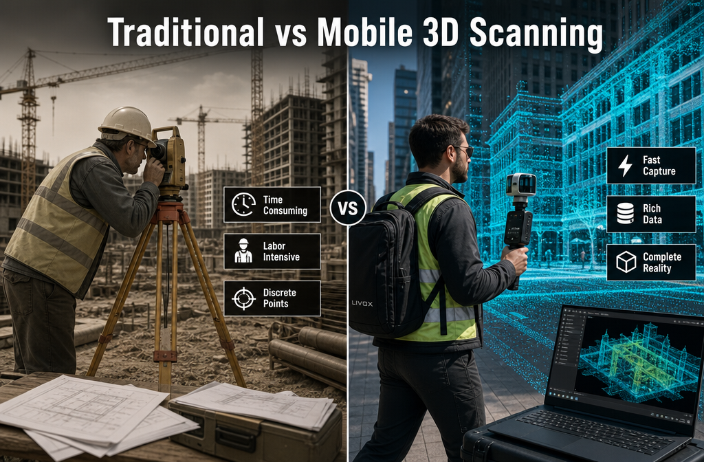
Traditional Surveys vs Mobile 3D Mapping: A Clear Divide
How Traditional Property Surveys Work
For decades, property surveys have relied on tape measures, total stations, and manual sketches. A surveyor visits a site, records dimensions by hand or with a basic electronic distance measurer, and then translates those notes into drawings back at the office. The process is time-consuming, labour-intensive, and — critically — dependent on the surveyor capturing every relevant detail during a finite site visit.
This approach works. It has produced reliable data for generations of property professionals. But it has clear limitations:
| Factor | Traditional Methods | Mobile 3D Laser Scanning |
|---|---|---|
| Data capture speed | Days to weeks | Hours |
| Accuracy | ±5–20mm typical | ±1–3mm typical |
| Data density | Selective measurements | Millions of points per second |
| Revisit requirement | Common | Rare |
| Integration with BIM/CAD | Manual re-entry | Direct import |
| Indoor/outdoor capability | Separate workflows | Unified workflow |
What Mobile 3D Mapping Actually Does
Mobile laser scanning — also called mobile LiDAR mapping — uses Light Detection and Ranging (LiDAR) sensors mounted on handheld devices, backpack rigs, or vehicle-mounted platforms. The scanner emits laser pulses and measures the time taken for each pulse to return after bouncing off a surface. Doing this millions of times per second across 360 degrees produces a point cloud: a dense, three-dimensional digital replica of the scanned environment.
💡 Pull Quote: "A point cloud is essentially a photograph in three dimensions — every surface, every edge, every recess captured simultaneously and permanently."
Unlike static terrestrial laser scanners (which must be repositioned repeatedly across a site), mobile systems allow the operator to walk through a building or around a site continuously, capturing data in real time. The result is a seamless digital twin of the property — indoors and outdoors — in a single pass.
This is particularly transformative for urban development projects, where sites are complex, access windows are narrow, and the cost of returning to site is high.

Mobile 3D Mapping and Laser Scanning: Future-Proofing Property Surveys Across Key Use Cases
Commercial Property and Development Projects 🏢
Urban development rarely involves simple, rectangular buildings. Mixed-use schemes, listed structures, and phased construction projects demand precise, up-to-date spatial data at every stage. Mobile 3D mapping delivers exactly that.
For commercial property surveying, laser scanning enables:
- Pre-acquisition surveys that capture the full condition and geometry of a building before purchase
- As-built verification, confirming that construction matches approved drawings
- Clash detection in BIM workflows, identifying conflicts between structural, mechanical, and electrical elements before they become costly on-site problems
- Facade and structural monitoring over time, detecting millimetre-level movement or deformation
The speed advantage is not just about convenience. On active construction sites, minimising the time surveyors spend on site reduces disruption, improves safety, and lowers project costs.
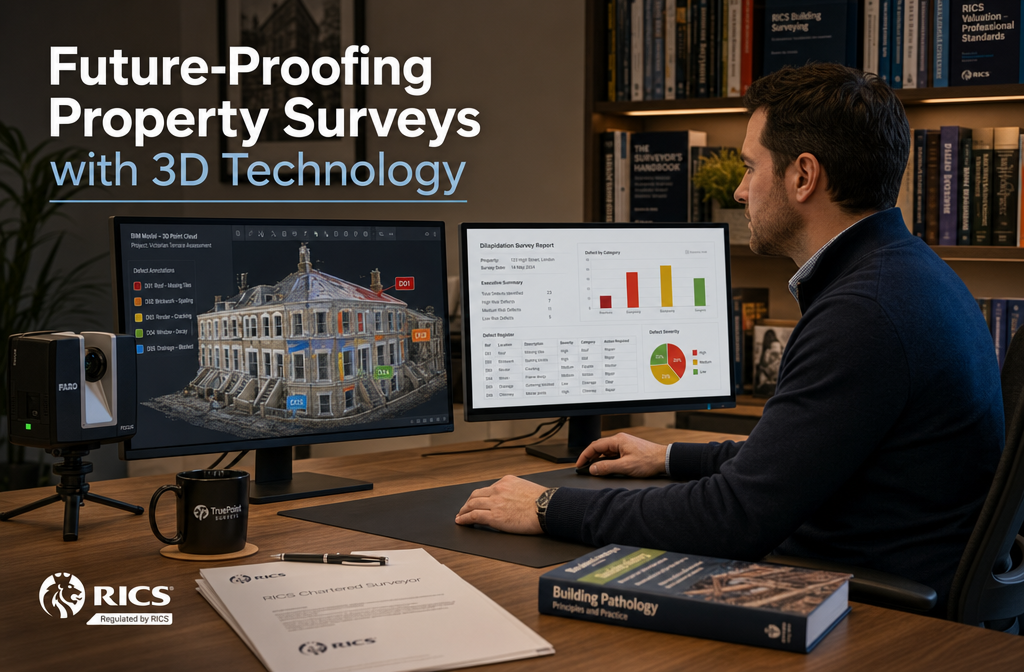
Dilapidation Surveys and Schedule of Condition Reporting
One of the most legally sensitive applications of mobile scanning is in dilapidation and condition reporting. When a commercial lease ends, disputes over the state of a property can be costly and contentious. A laser-scanned schedule of condition provides an irrefutable, timestamped, three-dimensional record of a property's state at a specific point in time.
Compared to photographs and written notes — which remain open to interpretation — a point cloud dataset can be measured, re-examined, and cross-referenced years after the original survey. This level of evidential robustness is increasingly valued in commercial lease negotiations and legal proceedings.
Similarly, a schedule of dilapidations supported by laser scan data gives landlords and tenants a defensible, objective baseline — reducing the risk of costly disputes.
Monitoring Surveys for Structural Movement 📐
Mobile and static laser scanning has become a cornerstone of structural monitoring on sensitive sites. Where a building is adjacent to tunnelling works, deep excavations, or other ground-disturbing activity, regular scanning captures any movement with precision that manual methods simply cannot match.
For professionals conducting monitoring surveys, the ability to compare sequential point cloud datasets — taken weeks or months apart — reveals trends in structural movement that would be invisible to the naked eye. This is critical for:
- Properties near HS2 or other major infrastructure projects
- Historic and listed buildings
- Sites with known subsidence risk
- Party wall situations where neighbouring construction is underway
Residential Surveys and Defect Detection 🏠
Mobile 3D scanning is not exclusively a commercial tool. High-value residential properties, complex conversions, and heritage homes increasingly benefit from laser-scanned surveys. A RICS-specific defect survey supported by point cloud data can reveal:
- Roof plane deformation invisible from ground level
- Wall bulging or bowing measured to the millimetre
- Floor level differentials indicating potential subsidence or settlement
- Geometric anomalies in extensions or conversions that may affect planning compliance
For homebuyers commissioning a building survey, a laser-scanned report provides a level of detail and accuracy that traditional visual inspections cannot replicate.
The Point Cloud Workflow: From Site to Deliverable
Understanding the end-to-end process helps property professionals appreciate both the value and the practicality of mobile scanning:
- Pre-survey planning — Define the scope, access requirements, and deliverable formats (point cloud, BIM model, 2D drawings, etc.)
- Mobile data capture — Operator walks or drives through the site with the scanning system; data is captured continuously
- Registration and processing — Raw scan data is processed using specialist software (e.g., Leica Cyclone, Trimble RealWorks, Faro Scene) to align and clean the point cloud
- Deliverable generation — Point clouds are used to produce floor plans, elevations, sections, BIM models, or condition reports
- Quality assurance — Accuracy is verified against known control points; the dataset is archived for future reference
The entire workflow — from site visit to final deliverable — can often be completed within 24–48 hours for a mid-sized commercial property, compared to one to two weeks using traditional methods.
Mobile 3D Mapping and Laser Scanning: Future-Proofing Property Surveys — Technology, Standards, and What Comes Next
Current Technology Landscape 🔬
The mobile scanning market has matured rapidly. Key platforms used in UK property surveying in 2026 include:
- Leica BLK2GO — A handheld SLAM-based scanner ideal for indoor environments
- NavVis VLX — A wearable system designed for large, complex buildings
- Trimble MX9 — A vehicle-mounted system for external and streetscape surveys
- Matterport Pro3 — A more accessible option increasingly used for residential and smaller commercial spaces
SLAM technology (Simultaneous Localisation and Mapping) is the key enabler of truly mobile scanning. Rather than relying on GPS (which is unavailable indoors), SLAM algorithms allow the scanner to build a map of its environment in real time while simultaneously tracking its own position within that map. The result is a coherent, accurate point cloud even in GPS-denied environments like basements, car parks, and multi-storey interiors.
Integration with BIM and Digital Twins
The UK government's mandate for BIM Level 2 on public sector projects has accelerated the adoption of laser scanning as a data capture method. Point clouds serve as the geometric foundation for BIM models — providing accurate as-existing data that would otherwise require extensive manual measurement.
Beyond BIM, the concept of the digital twin — a continuously updated virtual replica of a physical asset — relies on regular, accurate spatial data capture. Mobile laser scanning is the most practical method for keeping digital twins current, particularly for large or complex estates.
Regulatory and Professional Standards
RICS (Royal Institution of Chartered Surveyors) has published guidance on the use of measured survey data, including laser scanning, within its Measured Surveys of Land, Buildings and Utilities guidance note. This sets out accuracy standards, deliverable specifications, and quality assurance requirements that professional surveyors must meet.
As scanning technology becomes more accessible, the expectation from clients — particularly institutional investors and major developers — is shifting. Laser-scanned data is increasingly specified as a contractual requirement rather than an optional enhancement.
Challenges and Honest Limitations ⚠️
Mobile 3D scanning is not without its challenges:
- Cost of equipment remains significant, though rental and survey-as-a-service models are reducing barriers
- Data processing requires specialist software skills and computing power
- Reflective or transparent surfaces (glass, mirrors, water) can produce noise or gaps in point cloud data
- Dynamic environments (moving people, vehicles) require careful data cleaning
- Client education — many property owners and solicitors are still unfamiliar with point cloud deliverables and require guidance on interpretation
Despite these limitations, the trajectory is clear. Processing software is becoming more automated, hardware costs are falling, and client awareness is growing.
Practical Guidance for Property Professionals
When to Specify Mobile Laser Scanning
Not every survey requires mobile 3D scanning. A straightforward RICS HomeBuyer Survey on a standard semi-detached property does not need point cloud data. However, laser scanning adds clear value when:
✅ The property is large, complex, or multi-storey
✅ Accurate as-built drawings are required for planning, refurbishment, or sale
✅ A legally defensible condition record is needed (leases, party wall matters, disputes)
✅ Structural monitoring over time is required
✅ The project involves BIM or digital twin workflows
✅ Heritage or listed building status demands non-contact measurement methods
Questions to Ask Your Surveyor
When commissioning a survey that may benefit from laser scanning, ask:
- What scanning platform and software will be used?
- What accuracy specification will the data be delivered to?
- In what format will deliverables be provided (point cloud, BIM, 2D drawings)?
- How will the data be stored and made available for future reference?
- Is the surveyor RICS-accredited and familiar with the relevant guidance notes?
Engaging a chartered surveyor who understands both the technology and the professional standards governing its use is essential for getting reliable, actionable results.
Conclusion: Act Now, Not Later
The gap between surveyors who have integrated mobile 3D mapping into their practice and those who have not is widening every year. Mobile 3D Mapping and Laser Scanning: Future-Proofing Property Surveys is not a theoretical future state — it is the present standard for high-quality, defensible, and efficient property data capture in 2026.
For property owners, developers, and asset managers, the actionable steps are straightforward:
- Audit your current survey specifications — Are they capturing the level of detail your projects actually require?
- Engage scanning-capable surveyors — Ask specifically about mobile LiDAR capability when commissioning measured surveys, dilapidation assessments, or condition reports.
- Invest in understanding the deliverables — Point cloud data and BIM models are assets. Learn how to use them across your project lifecycle.
- Build scanning into contracts early — Specifying laser-scanned data at the outset of a project avoids costly retrospective surveys.
- Archive your data — A laser-scanned record of a property today is a powerful legal and commercial asset tomorrow.
The properties and projects that will perform best over the next decade are those underpinned by accurate, rich, reusable spatial data. Mobile laser scanning is the most practical path to that foundation. The technology is here, the standards are established, and the competitive advantage belongs to those who act first.