More than 6.3 million properties in England alone are at risk of flooding — yet the majority of homebuyers still receive valuations that treat flood risk as a footnote rather than a fundamental driver of market value. As the Environment Agency updates its flood mapping data and lenders tighten their lending criteria in response to climate science, the question is no longer whether flood risk affects UK property values — it is by how much, and how surveyors should quantify it.
Flood Risk, Climate Change and UK Valuations: How Surveyors Should Adjust Residential and Buy-to-Let Values is one of the most pressing challenges facing RICS-registered professionals in 2026. This article sets out a structured, evidence-based framework for surveyors working on residential and buy-to-let (BTL) instructions, drawing on updated Environment Agency data, lender appetite shifts, and RICS Red Book compliance requirements.
Key Takeaways 📋
- Flood risk is a material valuation factor — surveyors have a professional duty to reflect it in Red Book-compliant reports.
- Climate change is accelerating flood frequency, making historic comparable evidence increasingly unreliable without adjustment.
- Lender appetite is shrinking for high flood-risk properties, directly affecting mortgage availability and therefore market value.
- Insurance availability and premium costs must be considered as part of any holistic flood-risk valuation adjustment.
- Resilience measures (flood doors, raised electrics, permeable landscaping) can partially offset value reductions and should be assessed on site.
Understanding the Flood Risk Landscape in 2026
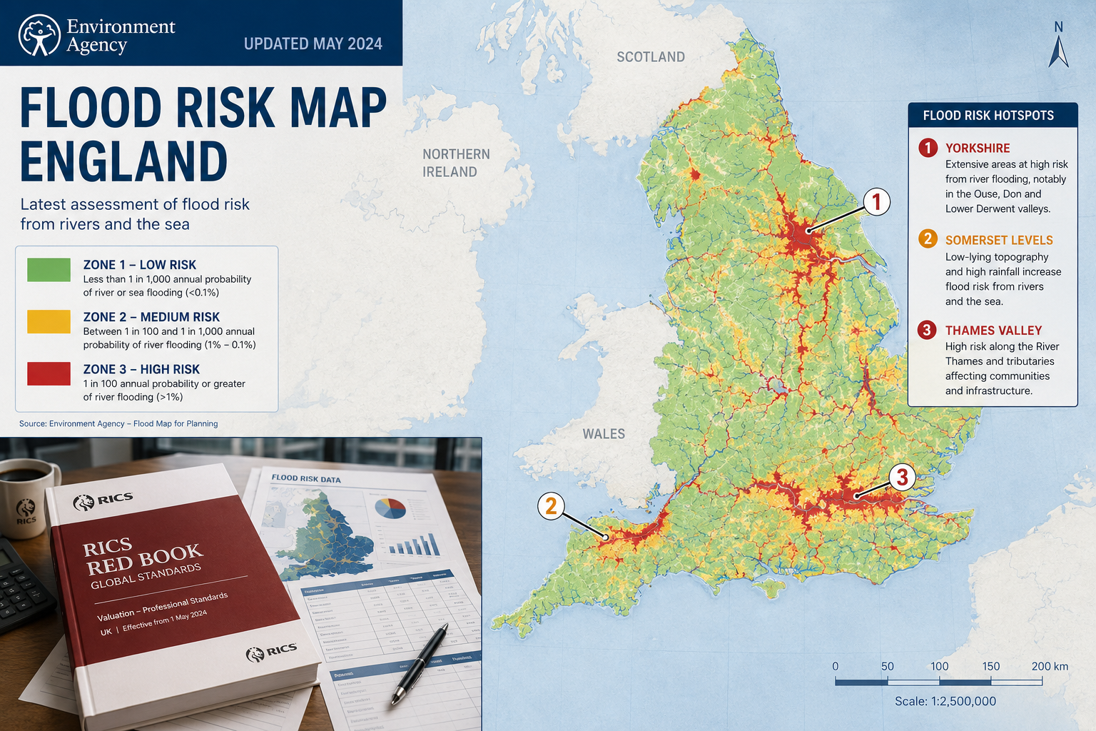
The Environment Agency's Updated Flood Mapping
The Environment Agency (EA) publishes the Long Term Flood Risk Assessment tool, which categorises land into three primary flood zones:
| Flood Zone | Annual Probability of Flooding | Description |
|---|---|---|
| Zone 1 | Less than 0.1% (1 in 1,000) | Low probability |
| Zone 2 | 0.1% – 1% (1 in 1,000 to 1 in 100) | Medium probability |
| Zone 3a | Greater than 1% (1 in 100 or more) | High probability |
| Zone 3b | Functional floodplain | Highest risk |
In 2026, the EA has significantly expanded its surface water flood mapping — a critical development, because surface water flooding (caused by overwhelmed drainage systems during heavy rainfall) now accounts for a growing proportion of flood damage claims across urban areas including Greater Manchester, Leeds, and parts of South East London.
💡 Key insight: Surface water flood risk is frequently absent from older valuation reports. Surveyors must now consult both fluvial (river) and surface water flood maps as standard practice.
Climate Change Is Rewriting the Risk Calculus
The UK Climate Projections (UKCP18) data, updated by the Met Office, projects that:
- Extreme rainfall events that were once 1-in-100-year occurrences could become 1-in-30-year events by 2050 under mid-range emissions scenarios.
- Sea levels around the UK coastline are expected to rise by 0.2 to 1.0 metres by 2100.
- River flow during winter months is projected to increase significantly across northern and western England.
For surveyors, this means that a property currently sitting in Flood Zone 2 may effectively carry Zone 3 risk within the lifetime of a 25-year mortgage. Comparable sales evidence from five or more years ago may materially understate current risk — and surveyors must apply professional judgement accordingly.
How Flood Risk, Climate Change and UK Valuations Interact: The Valuation Methodology
Red Book Compliance and Material Valuation Uncertainty
RICS Valuation — Global Standards (the Red Book) requires surveyors to identify and reflect all material factors affecting value. Flood risk unambiguously qualifies. Where flood risk creates significant uncertainty — for example, where insurance is unavailable or where the property has flooded multiple times — surveyors should consider issuing a Material Valuation Uncertainty (MVU) declaration under VPS 3 of the Red Book.
An RICS Red Book valuation must therefore:
- Identify the flood zone classification from EA mapping.
- Investigate surface water, groundwater, and sewer flood risk separately.
- Assess insurance availability and the Flood Re scheme eligibility.
- Review any flood resilience or resistance measures installed.
- Analyse comparable evidence, adjusting for flood risk differentials between properties.
- Reflect the risk in the opinion of value with transparent commentary.
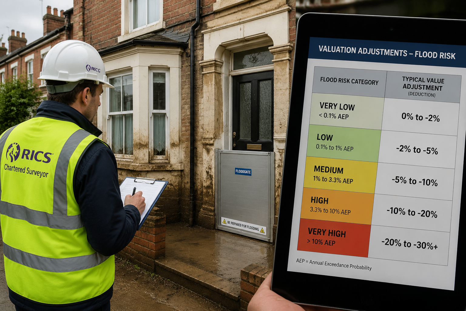
Quantifying the Value Adjustment
There is no single prescribed percentage deduction for flood risk — and surveyors should be cautious of applying formulaic adjustments without market evidence. However, academic research and transactional data provide useful benchmarks:
- A University of Exeter study found that properties in high flood-risk areas sold for an average of 8–12% less than comparable low-risk properties, with discounts widening after a flood event.
- Properties that have actually flooded typically suffer discounts of 15–25% or more, particularly where remediation is incomplete.
- Properties in Zone 3b (functional floodplain) with no viable insurance may see discounts exceeding 30% in some markets.
⚠️ Surveyor's note: These figures are indicative. The actual adjustment must be anchored to local comparable evidence, lender appetite, and insurance availability in the specific submarket.
The Role of Flood Re
Flood Re is a reinsurance scheme operated by the insurance industry and backed by government, designed to make flood insurance affordable for high-risk homes. Key points for surveyors:
- Flood Re covers domestic properties built before 2009 — properties built after this date are excluded.
- Leasehold flats in blocks of four or more units are excluded.
- Where Flood Re applies, insurance availability is generally maintained, which partially mitigates the value impact.
- Where a property falls outside Flood Re eligibility, insurance may be unavailable or prohibitively expensive — a significant negative value factor.
Surveyors should confirm Flood Re eligibility as part of every flood-risk valuation instruction. This is particularly relevant for RICS valuations used for mortgage purposes, where lenders will require evidence of insurability.
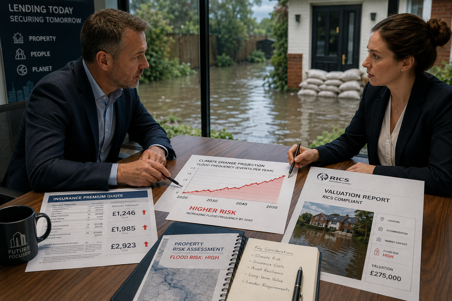
Lender Appetite and Its Direct Impact on Market Value
A property's market value is inextricably linked to its mortgageability. In 2026, several major UK lenders have introduced or tightened flood-risk policies:
- Some lenders decline to lend on properties in Flood Zone 3 without evidence of adequate flood defences and insurance.
- Others apply reduced loan-to-value (LTV) ratios — for example, capping at 75% LTV rather than 90% — on Zone 2 properties.
- Specialist lenders may lend but at higher rates, reducing buyer pool and therefore market value.
📌 Pull quote: "A property that cannot be mortgaged by mainstream lenders is, in practical terms, worth less — regardless of its physical condition. Surveyors must factor lender appetite into every flood-risk valuation."
Understanding the difference between a mortgage valuation and a survey is important here. A mortgage valuation serves the lender's security interests, and flood risk is a central concern in that context.
Flood Risk, Climate Change and UK Valuations: Buy-to-Let Considerations
Why BTL Properties Face Amplified Flood Risk Exposure
Buy-to-let properties carry additional layers of flood risk exposure that residential owner-occupied valuations do not fully capture:
- Rental voids during flood events and remediation periods directly impact investment returns.
- Tenant liability and landlord obligations under the Landlord and Tenant Act mean landlords bear remediation costs that owner-occupiers might absorb differently.
- Buildings insurance for BTL properties is often more expensive and harder to obtain in flood-risk areas.
- Lender appetite for BTL mortgages in flood zones is even more restricted than for residential lending.
For surveyors undertaking BTL valuations, the investment method of valuation must reflect these factors. Where a property is at high flood risk:
- Apply a higher capitalisation rate (lower yield multiple) to reflect increased risk.
- Adjust net income downward to account for likely insurance cost premiums and void periods.
- Consider whether the property is likely to remain lettable following future flood events.
Resilience Measures: Partial Value Recovery
Not all flood-risk properties are equally vulnerable. Surveyors should assess and credit the following flood resilience and resistance measures:
Flood Resistance (keeping water out):
- Flood doors and barriers 🚪
- Air brick covers
- Non-return valves on drainage systems
- Raised electrical sockets and consumer units
Flood Resilience (reducing damage when water enters):
- Concrete or tiled ground floors (replacing timber)
- Lime plaster (dries faster than gypsum)
- Raised kitchen units
- Waterproof insulation materials
✅ A property with comprehensive resilience measures may warrant a smaller downward adjustment than an equivalent unprotected property, provided the surveyor can verify the measures are properly installed and maintained.
For a thorough assessment of structural integrity in flood-affected properties, a Level 3 RICS building survey is strongly recommended, as it provides the depth of investigation needed to identify hidden flood damage, compromised foundations, and drainage vulnerabilities.
Drainage condition is a frequently overlooked factor. A drainage survey can reveal whether existing systems are adequate to handle increased surface water volumes — directly relevant to flood risk assessment.
Regional Hotspots Surveyors Should Monitor Closely
Certain UK regions warrant heightened flood-risk scrutiny in 2026:
- Yorkshire and Humber — ongoing fluvial flood risk from the Rivers Aire, Calder, and Don.
- Somerset Levels — persistent groundwater and surface water risk.
- Thames Valley — tidal and fluvial risk, particularly downstream of Oxford.
- Greater Manchester — urban surface water risk exacerbated by impermeable surfaces.
- Surrey and the Home Counties — River Mole, Wey, and Thames tributaries affecting areas including Weybridge and Leatherhead.
- South East London — tidal risk and surface water issues affecting South East London boroughs.
Practical Steps for Surveyors: A Compliance Checklist
Surveyors should embed the following steps into every residential and BTL valuation instruction where flood risk is identified or suspected:
Pre-Inspection Research
- Check EA Long Term Flood Risk Assessment (fluvial, surface water, groundwater, reservoir)
- Review local authority Strategic Flood Risk Assessment (SFRA)
- Check planning history for any flood-related conditions or restrictions
- Confirm Flood Re eligibility
- Review lender-specific flood risk criteria (if acting for mortgage purposes)
On-Site Inspection
- Look for physical evidence of previous flooding (tide marks, salt deposits, replaced finishes)
- Assess flood resilience and resistance measures
- Inspect ground floor construction and drainage outlets
- Note proximity to watercourses, culverts, and drainage infrastructure
- Consider commissioning a drainage survey if risk indicators are present
Valuation Report
- Disclose flood zone classification explicitly
- Comment on insurance availability and Flood Re status
- Reflect flood risk in the opinion of value with transparent reasoning
- Consider MVU declaration where uncertainty is material
- Recommend further investigations where evidence is inconclusive
The Future Direction: Climate Risk and Valuation Standards
The RICS has signalled that climate risk — including flood risk — will become an increasingly formalised component of valuation practice. In 2026, the profession is moving toward:
- Mandatory climate risk disclosure in valuation reports.
- Standardised flood risk adjustment frameworks developed in collaboration with lenders and insurers.
- Integration of climate scenario modelling (using UKCP18 projections) into long-term investment valuations.
For surveyors, staying ahead of this curve is not optional — it is a professional obligation. The RICS home survey and valuation frameworks are evolving, and practitioners who develop expertise in climate-adjusted valuations will be better positioned to serve clients and withstand regulatory scrutiny.
Conclusion: Actionable Next Steps for Surveyors
Flood Risk, Climate Change and UK Valuations: How Surveyors Should Adjust Residential and Buy-to-Let Values is a topic that has moved from the margins to the mainstream of UK surveying practice. The combination of updated EA flood mapping, shrinking lender appetite, rising insurance costs, and accelerating climate projections means that surveyors who fail to adequately reflect flood risk in their Red Book valuations face both professional liability and reputational risk.
Actionable next steps for surveyors in 2026:
- Update your flood risk research toolkit — incorporate surface water flood maps alongside fluvial data as standard.
- Develop a clear valuation adjustment methodology anchored to local comparable evidence and lender criteria.
- Build Flood Re eligibility checks into every pre-inspection checklist.
- Recommend specialist surveys — including Level 3 building surveys and drainage investigations — where flood risk indicators are present.
- Engage with RICS guidance updates on climate risk disclosure as they are published.
- Communicate clearly with clients about the difference between a flood risk assessment and a valuation, and why both matter.
The properties most at risk are not just those that have flooded before — they are the millions sitting in zones that climate science tells us will flood in the future. Surveyors who understand this are not being alarmist; they are being accurate.
References
- Environment Agency. (2023). Long Term Flood Risk Assessment. UK Government. https://www.gov.uk/check-long-term-flood-risk
- Flood Re. (2024). How Flood Re works. https://www.floodre.co.uk/how-it-works/
- Met Office. (2019). UK Climate Projections 2018 (UKCP18). https://www.metoffice.gov.uk/research/approach/collaboration/ukcp
- RICS. (2022). RICS Valuation — Global Standards (Red Book Global). Royal Institution of Chartered Surveyors.
- Lamond, J., & Proverbs, D. (2009). Flood resilience of the built environment. Proceedings of the Institution of Civil Engineers — Engineering Sustainability, 162(4), 197–204.
- University of Exeter. (2021). The impact of flood risk on residential property values. European Centre for Environment and Human Health.
- Association of British Insurers. (2023). Flood insurance and the Flood Re scheme: Annual report. ABI.