Over 175,000 boundary disputes are estimated to arise across England and Wales every year — and the majority escalate unnecessarily because the technical evidence presented is either incomplete, non-compliant, or produced by surveyors without the correct accreditation. Understanding Expert Witness Roles in Boundary Disputes: RICS Land Registry Protocols and Drone Survey Integration 2026 is no longer a niche concern for property lawyers; it is essential knowledge for any property owner facing a fence-line conflict, encroachment claim, or garden boundary disagreement in 2026.
This guide breaks down exactly what a qualified expert witness does, how RICS accreditation standards work, what Land Registry protocols apply, and how drone survey technology is transforming the accuracy and credibility of boundary evidence in modern disputes.
Key Takeaways 📌
- RICS-accredited expert witnesses must complete structured training, ethics testing, and formal interviews to maintain their standing on the official register [2].
- CPR Part 35 compliance is mandatory for any expert witness report submitted to a court — failure to comply can invalidate evidence entirely.
- Drone surveys now provide sub-centimetre accuracy for boundary mapping, significantly reducing measurement disputes.
- HM Land Registry title plans are indicative, not definitive — expert witnesses must interpret them alongside physical evidence and historical deeds.
- Choosing an RICS-accredited expert witness with drone survey capability gives parties the strongest possible evidential foundation in 2026.
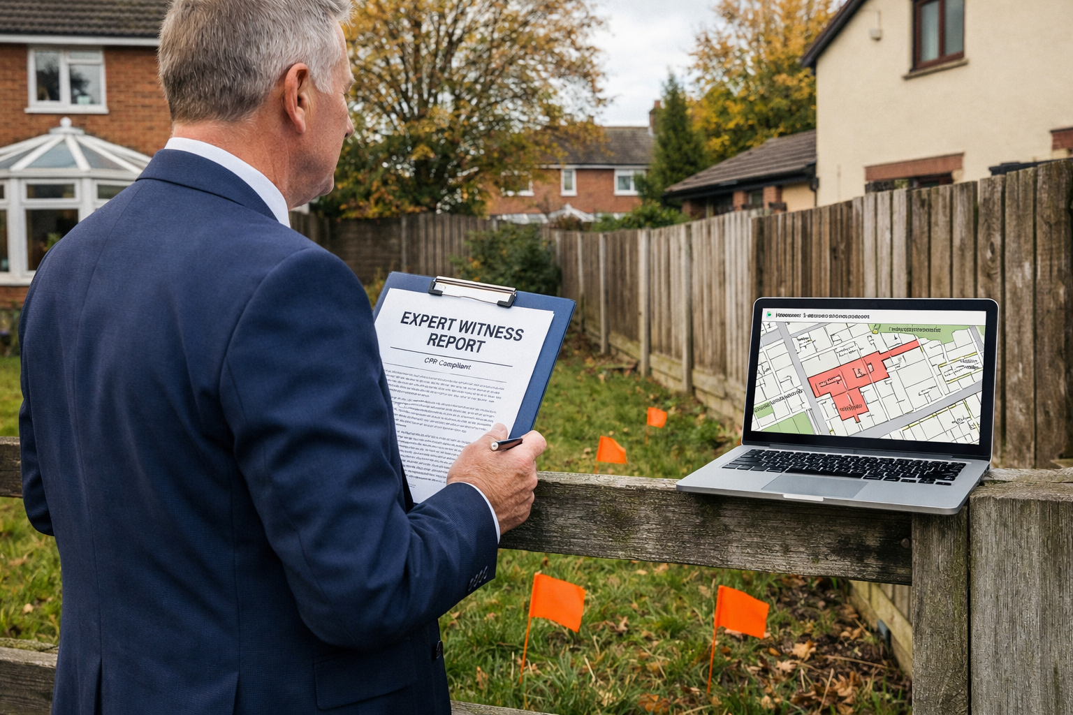
What Does an Expert Witness Do in a Boundary Dispute?
A boundary dispute expert witness is not simply a surveyor who measures land. Their role is fundamentally different from that of a standard property surveyor. They are appointed — either jointly or by one party — to provide impartial, court-admissible technical opinion on where a legal boundary lies and why.
The Duty to the Court, Not the Client
The single most important principle governing expert witnesses in England and Wales is that their primary duty is to the court, not to the party instructing them. This is enshrined in Civil Procedure Rules (CPR) Part 35, which sets out:
- The expert must be independent and objective
- Reports must contain a declaration of truth
- The expert must inform the court of any change in opinion
- Single Joint Expert (SJE) appointments are encouraged where possible
Failing to meet CPR Part 35 requirements can result in a report being inadmissible — a costly outcome for any litigant.
Core Tasks of a Boundary Dispute Expert Witness
| Task | Description |
|---|---|
| Title deed analysis | Reviewing conveyances, transfers, and Land Registry entries |
| Physical site inspection | Measuring and recording boundary features on-site |
| Historical research | Examining old Ordnance Survey maps, aerial photographs, and planning records |
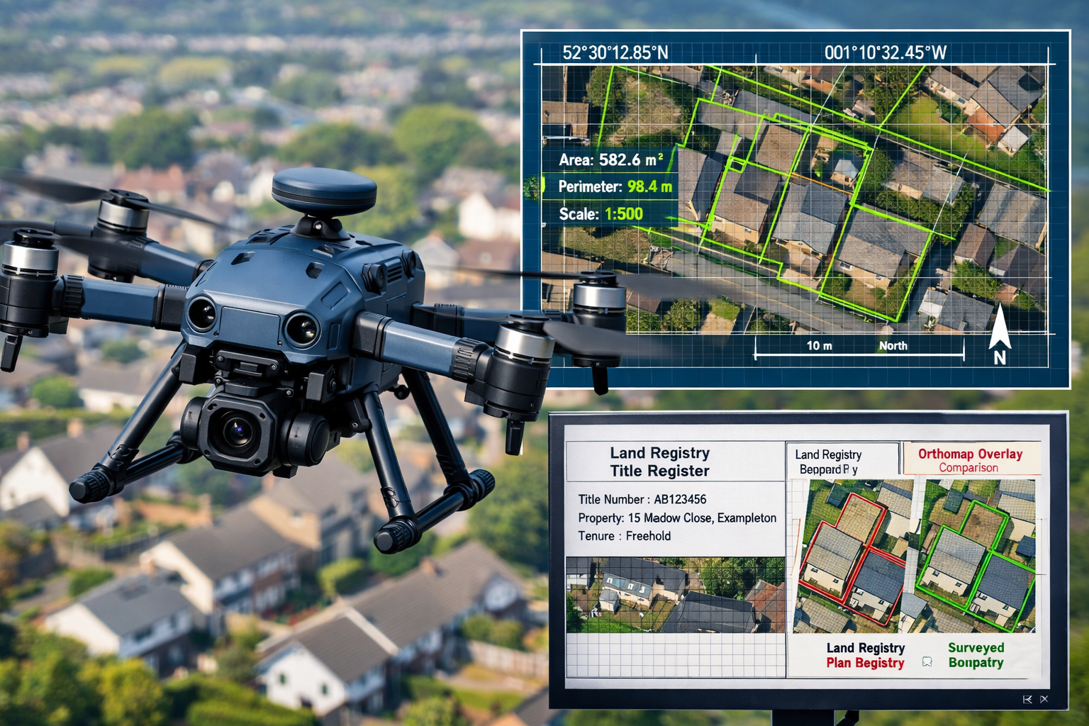
| Drone survey integration | Commissioning or conducting UAV surveys for precision mapping |
| Report preparation | Producing a CPR-compliant expert witness report |
| Joint statement | Meeting with opposing expert to narrow areas of disagreement |
| Court attendance | Giving oral evidence if required |
For a detailed overview of what a professional expert witness report contains, see this guide to expert witness reports.
RICS Accreditation and Land Registry Protocols in 2026
The RICS Register of Accredited Expert Witnesses
As of March 2026, RICS Dispute Resolution Services (DRS) maintains an official Register of Accredited Expert Witnesses — a publicly accessible document listing chartered surveyors qualified to act as expert witnesses across various specialties, including boundary disputes [2].
💬 "The RICS Register is not merely a directory — it is a quality assurance mechanism that signals to courts and legal professionals that the surveyor has met rigorous competency standards."
To appear on the register, RICS members must complete [1]:
- ✅ Four structured training modules covering expert witness duties, report writing, court procedure, and ethics
- ✅ An ethics test assessing understanding of CPR obligations and impartiality requirements
- ✅ A formal interview with RICS assessors to confirm practical competence
- ✅ Ongoing CPD to maintain accreditation status
RICS Dispute Resolution Services can also nominate an appropriate expert witness for specific cases. Parties or their solicitors can contact DRS directly at 020 7334 3806 or drs@rics.org [2].
This matters enormously in practice. A surveyor who simply holds RICS membership but has not completed expert witness accreditation may produce technically sound measurements — but their report may carry far less weight before a judge, or may not comply with CPR Part 35 at all.
To find a qualified RICS chartered surveyor for boundary work, always verify their standing on the official accreditation register.
How HM Land Registry Title Plans Work — and Their Limitations
One of the most persistent misconceptions in boundary disputes is that HM Land Registry title plans define the exact legal boundary. They do not.
Land Registry title plans are drawn at a scale of 1:1250 (urban) or 1:2500 (rural). At these scales, a line on the plan can represent anywhere from 0.5 to 1.5 metres on the ground. The Land Registry itself explicitly states that title plans show the general position of boundaries only.
What title plans do NOT show:
- Which side of a wall or fence the boundary falls on
- The exact position of a boundary to centimetre accuracy
- Who owns a party wall or shared fence
What expert witnesses must consider alongside title plans:
- Original conveyance deeds (often pre-dating Land Registry)
- Seller's property information forms (TA6)
- Historical Ordnance Survey maps
- Physical features such as hedges, walls, and ditches
- The "hedge and ditch" presumption and other common law rules
Understanding these layers of evidence is precisely why expert witness services require specialist training — not just surveying competence.
Drone Survey Integration for Expert Witness Roles in Boundary Disputes: RICS Land Registry Protocols and Drone Survey Integration 2026
Why Drone Technology Has Changed Boundary Surveying
The integration of Unmanned Aerial Vehicles (UAVs) into boundary surveying has been one of the most significant technical developments of recent years. In 2026, drone surveys are increasingly standard practice for expert witnesses handling complex or contested boundary cases.
Here is why:
🎯 Sub-centimetre accuracy — Modern survey drones equipped with Real-Time Kinematic (RTK) GPS can achieve positional accuracy of ±1–2 centimetres. This is orders of magnitude more precise than traditional tape measure surveys.
📐 Orthomosaic mapping — Drone imagery is processed into georeferenced orthomosaic maps, allowing boundary features to be measured directly from the aerial image with full coordinate data attached.
📊 Photogrammetric point clouds — 3D point cloud data allows surveyors to model ground surfaces, walls, and structures in three dimensions, resolving disputes about levels and encroachments that flat plans cannot capture.
📷 Contemporaneous visual record — Drone footage provides a timestamped, objective visual record of the site at the time of survey — invaluable if boundary features are subsequently altered or removed.
Drone Survey Workflow for Boundary Expert Witnesses
A professional drone survey for boundary dispute purposes typically follows this sequence:
- CAA compliance check — Confirming the site is within permitted airspace under UK Civil Aviation Authority regulations
- Ground Control Points (GCPs) — Placing physical markers at known coordinates to calibrate the drone's GPS data
- Flight planning — Programming automated flight paths to achieve full coverage at the required resolution
- Data capture — Flying the survey and capturing overlapping images (typically 70–80% overlap)
- Photogrammetric processing — Using specialist software (e.g., Pix4D, DJI Terra) to generate orthomosaics and point clouds
- Boundary overlay — Superimposing Land Registry title plan data onto the processed imagery for direct comparison
- Report integration — Embedding survey outputs into the CPR-compliant expert witness report
For cases involving structural features near boundaries — such as extensions, outbuildings, or retaining walls — structural surveys may also be required alongside the boundary drone survey to fully document the physical evidence.
Admissibility of Drone Survey Evidence
For drone survey data to be admissible and persuasive in court, expert witnesses must demonstrate:
- Calibration records for all survey equipment
- Methodology transparency — the report must explain how measurements were derived
- Qualified operator credentials — the surveyor or their appointed drone operator must hold appropriate CAA permissions
- Chain of custody for digital data files
Courts in England and Wales have increasingly accepted drone survey evidence in boundary cases, particularly where traditional ground surveys are impractical due to site access issues or where sub-centimetre precision is genuinely in dispute.
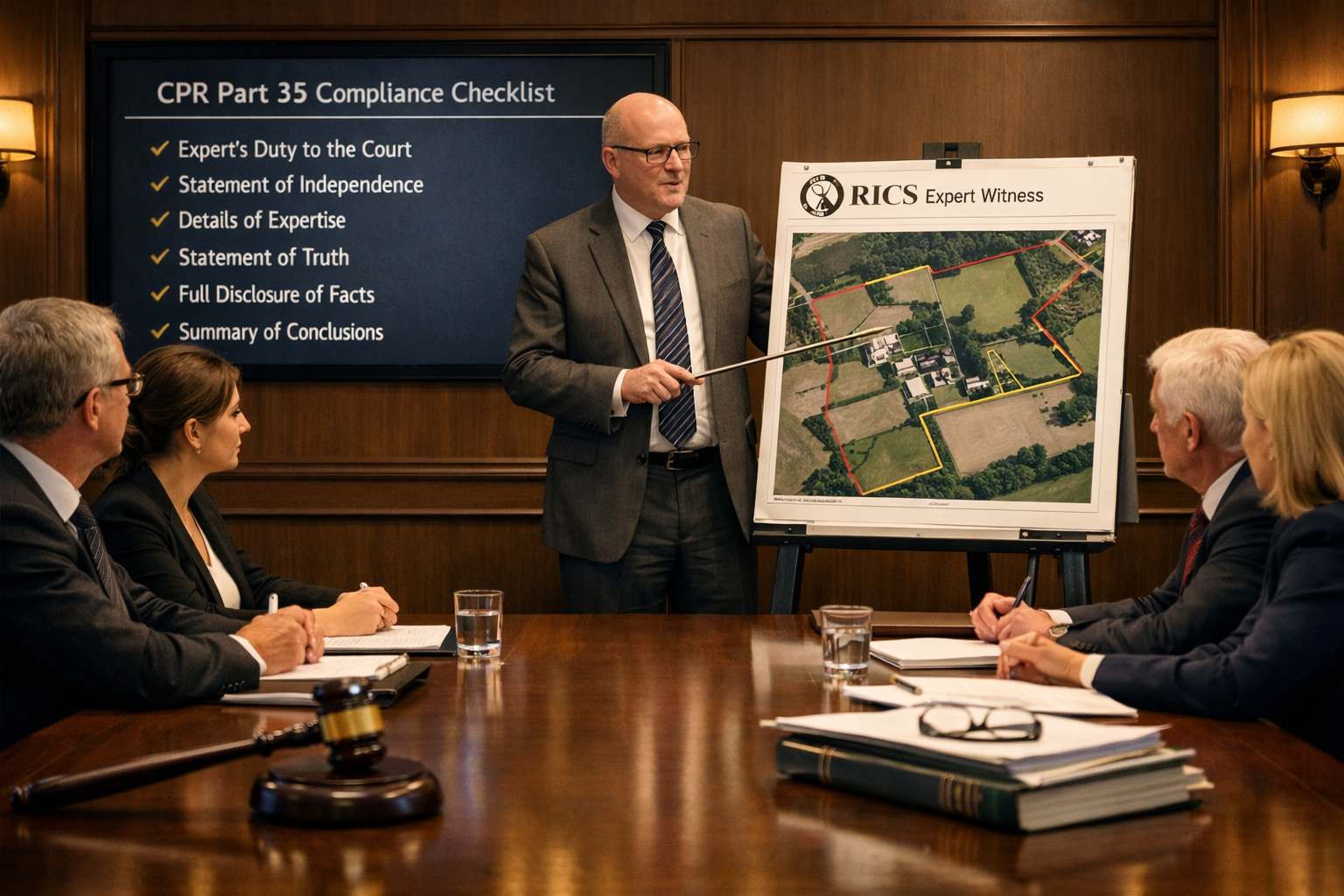
Preparing a CPR-Compliant Expert Witness Report for Boundary Cases
What the Report Must Contain
A boundary dispute expert witness report that complies with CPR Part 35 and the RICS Practice Statement on Expert Witnesses must include [1][3]:
- Expert's qualifications and experience — including RICS accreditation status
- Instruction summary — what questions the expert was asked to address
- Documents reviewed — title plans, deeds, correspondence, photographs
- Site inspection record — date, conditions, methodology, equipment used
- Drone survey data (where applicable) — methodology, accuracy statement, outputs
- Findings — the expert's technical conclusions on boundary position
- Opinion — a clear, reasoned statement of where the boundary lies and why
- Declaration of truth — the mandatory CPR Part 35 statement
- Statement of compliance — confirming the expert understands their duty to the court
💬 "A well-prepared CPR-compliant report does not just state conclusions — it shows its working. Judges want to understand the reasoning, not just the result."
Common Failings in Boundary Expert Reports
Based on case law and RICS guidance, the most frequent weaknesses in boundary expert reports include [1]:
| ❌ Common Failing | ✅ Best Practice |
|---|---|
| Advocacy for the instructing party | Balanced, objective analysis |
| Overreliance on title plan alone | Multi-source evidence approach |
| No methodology explanation | Full survey methodology disclosed |
| Missing CPR declaration | Declaration included and signed |
| Vague opinion on boundary position | Precise coordinates or measurements given |
| No consideration of opposing evidence | Opposing arguments addressed and evaluated |
The Joint Statement Process
Where both parties appoint their own expert witnesses, the court will typically direct them to meet and produce a Joint Statement identifying:
- Points of agreement
- Points of disagreement
- The reasons for any remaining disagreement
This process — sometimes called a "without prejudice" experts' meeting — frequently resolves disputes before trial. A skilled RICS-accredited expert witness will approach this meeting constructively, narrowing the issues rather than entrenching positions.
For cases that also involve shared walls or structures at the boundary, understanding party wall procedures can be equally important — though party wall matters are governed by a separate statutory framework under the Party Wall etc. Act 1996.
Applying Expert Witness Roles in Boundary Disputes: RICS Land Registry Protocols and Drone Survey Integration 2026 in Practice
Typical Boundary Dispute Scenarios in 2026
The following scenarios illustrate where RICS expert witness roles and drone survey integration are most commonly applied:
🏡 Garden encroachment — A neighbour erects a fence 0.8 metres inside what the other party believes is their garden. Drone orthomosaic mapping overlaid on historical OS maps resolves the position with millimetre-level precision.
🧱 Wall ownership disputes — Two adjoining owners disagree about which side of a boundary wall belongs to whom. The expert reviews conveyance deeds, examines the wall's physical construction, and applies common law presumptions.
🏗️ Development boundary conflicts — A developer's new build encroaches on a neighbouring title. Drone survey data is compared against the approved planning drawings and Land Registry title plan.
📐 Adverse possession claims — One party claims ownership by long use. The expert assesses physical occupation evidence against the legal boundary, using historical aerial photography and site inspection.
Costs and Timescales
Parties should be realistic about both costs and timescales when instructing an expert witness for a boundary dispute:
- Expert witness fees: Typically £2,000–£8,000+ depending on complexity, report length, and whether court attendance is required
- Drone survey costs: £500–£2,500 for a standard residential boundary survey
- Report preparation time: 4–8 weeks from instruction to delivery
- Court proceedings: If the matter proceeds to trial, total costs can reach £15,000–£50,000+ per party
This is why early, accurate expert evidence — particularly drone-assisted surveys — often saves significant cost by enabling early settlement. Many disputes that reach solicitors could be resolved at the expert witness stage if parties obtain proper technical evidence promptly.
For property owners who want to understand the broader cost landscape of professional surveying services, the monitoring surveys page provides useful context on ongoing measurement services that can also support boundary evidence.
Conclusion: Actionable Next Steps for 2026 Boundary Disputes
Boundary disputes are among the most emotionally charged and financially damaging property conflicts a homeowner can face. The good news is that in 2026, the combination of RICS-accredited expert witnesses, CPR-compliant reporting, and drone survey technology means that the technical evidence available to resolve these disputes has never been more precise or more persuasive.
✅ Actionable Steps
-
Verify RICS accreditation — Before instructing any surveyor as an expert witness, confirm they appear on the RICS Register of Accredited Expert Witnesses (updated March 2026) [2]. Contact RICS DRS at 020 7334 3806 if you need a nominated expert.
-
Instruct early — Expert witness evidence gathered before legal proceedings begin is often more cost-effective and can enable early settlement without court.
-
Request drone survey capability — Ask your expert witness whether drone survey integration is appropriate for your case. For most garden or boundary encroachment disputes, it will be.
-
Understand title plan limitations — Do not assume your Land Registry title plan resolves the dispute. An expert witness will need to examine multiple layers of evidence.
-
Consider a Single Joint Expert — Courts encourage SJE appointments where possible. This reduces costs and speeds up resolution.
-
Separate party wall matters — If your boundary dispute also involves a shared wall, ensure you understand the separate party wall award process and do not conflate the two legal frameworks.
-
Seek specialist advice promptly — The sooner qualified expert evidence is obtained, the greater the chance of resolving the dispute without expensive litigation.
For professional expert witness services from RICS-accredited chartered surveyors, including drone survey integration and CPR-compliant report preparation, specialist support is available across England and Wales in 2026.
References
[1] Expert Witness Preparation For Boundary Disputes Rics Site Survey Protocols And Land Registry Integration – https://nottinghillsurveyors.com/blog/expert-witness-preparation-for-boundary-disputes-rics-site-survey-protocols-and-land-registry-integration
[2] Rics Register Of Accredited Expert Witnesses March 2026 – https://www.rics.org/content/dam/ricsglobal/documents/surveying/RICS-Register-of-Accredited-Expert-Witnesses_March-2026.pdf
[3] Expert Witness Roles In Right Of Light Litigation Rics Evidence Standards Post 2026 Daylight Rights Reforms – https://nottinghillsurveyors.com/blog/expert-witness-roles-in-right-of-light-litigation-rics-evidence-standards-post-2026-daylight-rights-reforms