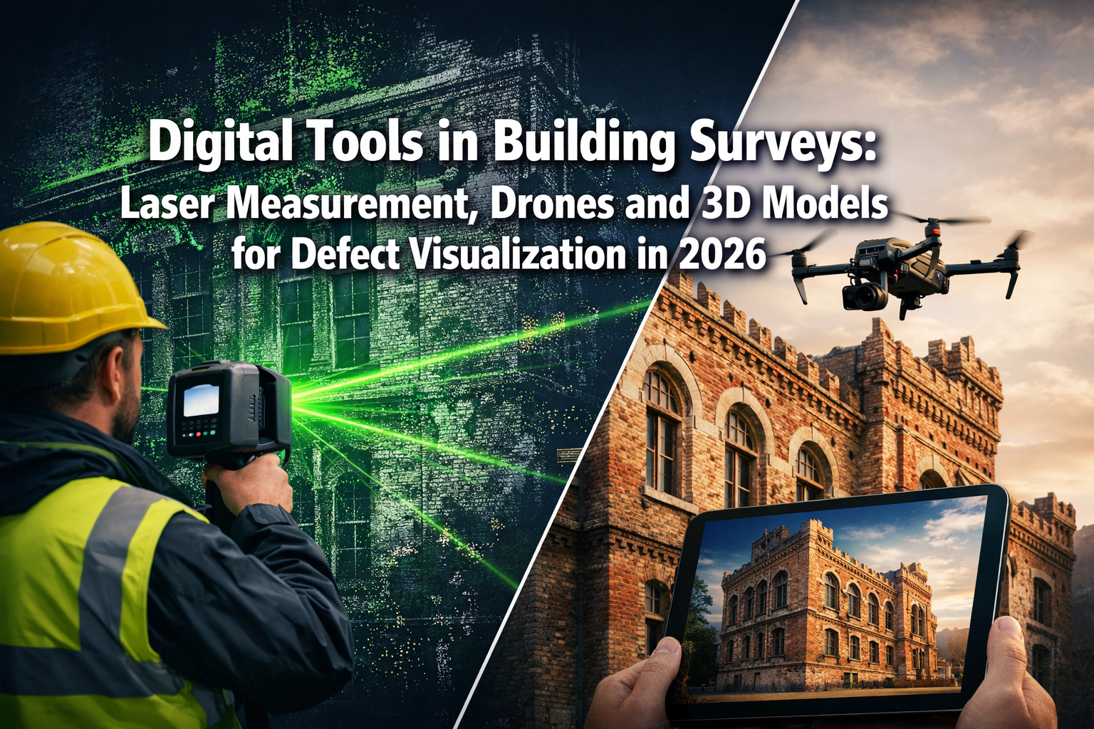
Picture this: you're about to purchase your dream property, but hidden behind those freshly painted walls could be structural defects worth thousands in repairs. In 2026, building survey reports have evolved far beyond basic photographs and written descriptions. Digital Tools in Building Surveys: Laser Measurement, Drones and 3D Models for Defect Visualization in 2026 are transforming how property buyers, surveyors, and construction professionals identify, document, and negotiate building defects with unprecedented clarity and confidence.
Gone are the days of relying solely on a surveyor's ladder and notepad. Today's advanced technologies reveal hidden issues in hard-to-reach areas—from deteriorating roof valleys to concealed structural movement—through immersive 3D visualizations that empower buyers to make informed decisions and negotiate repairs with concrete evidence in hand.
Key Takeaways
- Millimeter-precision laser scanning using RTK and SLAM technology eliminates measurement errors and reduces site time by up to 70% compared to traditional methods
- Drone-mounted LiDAR systems can survey up to 10 square kilometers in a single flight, capturing defects in inaccessible areas like chimneys, roofs, and tall facades
- 3D point cloud models enable verified dimension extraction and defect visualization, allowing buyers to see exactly where problems exist before committing to purchase
- Scan-to-BIM workflows create parametric building models that integrate seamlessly with CAD platforms for immediate engineering analysis and municipal compliance
- Real-time as-built comparisons help identify discrepancies between plans and actual construction, preventing costly errors and supporting evidence-based repair negotiations
Understanding Digital Tools in Building Surveys: Laser Measurement, Drones and 3D Models for Defect Visualization in 2026
The building survey industry has undergone a remarkable digital transformation. Traditional survey methods, while still valuable, often struggle with accessibility limitations, time constraints, and subjective interpretation. Modern digital tools address these challenges head-on by providing objective, measurable data that can be revisited, analyzed, and shared with multiple stakeholders.
The Evolution of Survey Technology
Building surveys have traditionally relied on visual inspection, tape measures, and manual note-taking. While experienced surveyors develop keen eyes for defects, these methods have inherent limitations:
- Access constraints prevent thorough inspection of roofs, chimneys, and upper-level facades
- Measurement accuracy varies based on conditions and human error
- Documentation gaps occur when defects are difficult to photograph or describe
- Time pressures limit the depth of investigation possible during site visits
Digital tools overcome these barriers by capturing comprehensive data in a fraction of the time. A RICS Building Survey enhanced with laser scanning and drone imagery provides clients with verifiable evidence rather than subjective opinions alone.
Key Technologies Reshaping Building Surveys
Three primary technologies are revolutionizing how surveyors document and visualize building defects in 2026:
| Technology | Primary Function | Key Advantage | Typical Application |
|---|---|---|---|
| Laser Scanning | Millimeter-precise 3D measurement | Eliminates manual measurement errors | Internal space documentation, structural alignment |
| Drone Surveying | Aerial inspection and mapping | Accesses dangerous or unreachable areas | Roof condition, facade defects, site topography |
| 3D Modeling | Defect visualization and analysis | Creates immersive, shareable documentation | Client presentations, repair specifications |
These technologies don't work in isolation. The most effective building surveys in 2026 integrate multiple digital tools to create comprehensive defect documentation that stands up to scrutiny during property negotiations.
Laser Measurement Technology: Achieving Millimeter Precision in Building Surveys
Laser scanning has become the gold standard for accurate dimensional surveys and defect measurement. Unlike traditional tape measures that require physical contact and line-of-sight access, laser scanners capture millions of measurement points per second, creating detailed 3D representations of building spaces and structures.
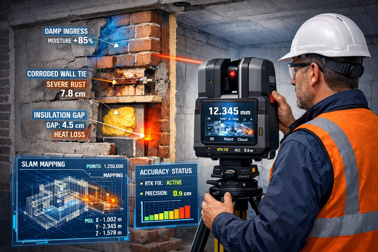
RTK and SLAM Integration for Survey-Grade Accuracy
Advanced surveying firms now employ integrated RTK (Real-Time Kinematic) and SLAM (Simultaneous Localization and Mapping) laser scanning technology to generate survey-grade point cloud data with millimeter precision[1]. This integration significantly reduces site time and project disruptions while maintaining the accuracy required for professional building surveys.
RTK technology uses GPS correction signals to achieve centimeter-level positioning accuracy, ensuring that laser scan data aligns perfectly with real-world coordinates. SLAM algorithms allow scanners to map environments in real-time without requiring external reference points, making them ideal for interior surveys where GPS signals are unavailable.
The combination delivers several critical advantages:
- ✅ Verified dimensions extracted directly from point cloud data
- ✅ Elimination of measurement guesswork and costly site revisits
- ✅ Alignment to project control and site datum for integration with architectural plans
- ✅ Reduced field time by 50-70% compared to traditional measurement methods
Applications in Defect Detection and Documentation
Laser scanning excels at identifying subtle defects that might escape visual inspection. When conducting a Specific Defect Report, laser technology can detect:
Structural Movement: By comparing laser scans taken at different times, surveyors can measure deflection, settlement, or structural movement with millimeter accuracy. This proves invaluable for subsidence surveys where precise measurement of wall displacement is critical.
Out-of-Plumb Walls: Point cloud data instantly reveals walls that lean or bulge, with color-coded deviation maps showing exactly where and how much surfaces deviate from true vertical or horizontal planes.
Floor Level Variations: Laser scanning captures complete floor surface topography, identifying dips, slopes, or unevenness that might indicate structural issues or poor construction quality—particularly important for snagging reports on new builds.
Ceiling Height Discrepancies: Accurate ceiling height measurements throughout a property can reveal concealed structural elements, lowered ceilings hiding defects, or non-compliance with building regulations.
From Point Clouds to Actionable Reports
Raw laser scan data consists of millions of individual measurement points forming a "point cloud." Modern survey software transforms these clouds into actionable information:
- Automated feature extraction identifies walls, floors, ceilings, and architectural elements
- Deviation analysis compares actual conditions to original plans or regulatory standards
- Cross-section generation creates detailed slices through buildings to reveal internal conditions
- Measurement extraction pulls accurate dimensions for repair specifications and cost estimation
This data feeds directly into comprehensive RICS Building Surveys Level 3, providing clients with objective measurements to support defect descriptions and repair recommendations.
Drone Technology: Accessing the Inaccessible in Building Surveys
Drones have revolutionized building surveys by providing safe, cost-effective access to areas that were previously dangerous, expensive, or impossible to inspect thoroughly. In 2026, drone surveying has become standard practice for comprehensive property assessments, particularly for larger buildings, complex rooflines, and multi-story structures.
Extended Coverage and Superior Vertical Accuracy
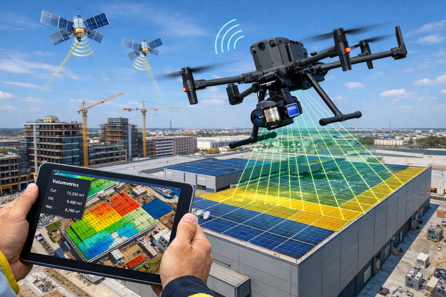
Fixed-wing drones equipped with LiDAR payloads can cover up to 10 square kilometers in a single flight by leveraging broader scanning angles[2]. This capability makes them ideal not just for individual building surveys but also for Stock Condition Surveys across large property portfolios.
LiDAR excels in achieving absolute accuracy through laser pulses that directly measure distances. Integration of GNSS data provides high levels of vertical accuracy for digital terrain maps, eliminating errors inherent in manual measurements[2]. This precision proves essential when surveying:
- Roof condition and defects: Missing tiles, damaged flashing, ponding water, vegetation growth
- Chimney stacks: Leaning, deterioration, pointing failure, structural cracks
- High-level facades: Render failure, brick spalling, window defects, balcony safety issues
- Guttering and drainage: Blockages, sagging, detachment, overflow damage
Dense Point Cloud Generation for Comprehensive Analysis
LiDAR systems produce high-density point cloud datasets with laser pulse rates playing a crucial role in data reliability[2]. This enables surveyors to create accurate 3D models while accounting for elevation and vegetation that might obscure building features.
Advanced systems like the JoLiDAR-1500 combine 1500-meter long-range laser scanning with inertial navigation systems and high-resolution 61MP RGB cameras, mounted on UAVs with 240-minute flight times and 200km extended range[2]. These capabilities enable:
🔍 Multi-spectral analysis: Combining visual RGB imagery with thermal imaging to detect heat loss, moisture intrusion, and insulation defects
📊 Volumetric calculations: Near-instant measurements for stockpile monitoring, excavation verification, and material quantity estimation[4]
🏗️ As-built verification: Real-time site models that help teams identify discrepancies before they become costly errors[4]
Integration with Traditional Survey Methods
Rather than replacing traditional methods like total stations or ladder-based inspections, drones complement existing technologies by filling data gaps and reducing repetitive fieldwork[4]. This multi-method approach gives surveyors flexibility to choose the optimal tool for each specific task.
For example, a comprehensive Homebuyer Survey might combine:
- Drone aerial survey for roof and chimney inspection
- Laser scanning for internal room measurements and structural alignment
- Traditional inspection for detailed examination of accessible defects
- Thermal imaging from ground level for damp and insulation assessment
This integrated approach ensures nothing is missed while optimizing survey efficiency and cost-effectiveness.
Periodic Monitoring and Progress Documentation
Because drone surveys are relatively inexpensive compared to scaffolding or cherry picker hire, they can be used periodically during projects to monitor progress and surface potential issues[3]. Overlaid imagery provides real-time insights into construction alignment with planned specifications.
This capability proves particularly valuable for:
- Dilapidation surveys documenting property condition before and after adjacent construction work
- Schedule of Condition reports establishing baseline property state for lease agreements
- Project monitoring during renovation or construction phases
- Insurance documentation following storm damage or other incidents
3D Models and BIM Integration: Visualizing Defects for Better Decision-Making
The ultimate goal of digital survey tools is transforming raw data into actionable insights that property buyers, owners, and professionals can use to make informed decisions. Three-dimensional modeling and Building Information Modeling (BIM) integration represent the culmination of this process.
Scan-to-BIM Workflows for Municipal Compliance
Modern survey practices deliver survey-grade parametric Revit models with complete municipal drawing packs, including site plans, floor plans, elevations, sections, and area calculations[1]. These models ensure municipal submission compliance and provide certified area calculations for property transactions.
The scan-to-BIM workflow typically involves:
- Data capture: Laser scanning and drone surveying collect raw measurement data
- Point cloud processing: Software cleans, aligns, and optimizes scan data
- Model creation: Parametric elements (walls, floors, roofs, openings) are built from point clouds
- Defect annotation: Identified issues are tagged, classified, and dimensioned within the model
- Report generation: Automated extraction of plans, sections, and schedules with defect overlays
This approach transforms a traditional RICS Specific Defect Survey from a written report with photographs into an interactive 3D experience where clients can virtually "walk through" their potential purchase and see exactly where problems exist.
Real-Time As-Built Models for Defect Detection
Drone mapping missions generate current site models that feed directly into Building Information Models to ensure alignment with actual site conditions[4]. This capability helps identify:
- Design-to-construction discrepancies: Where built elements don't match approved plans
- Spatial conflicts: Clashes between building services, structure, and architectural elements
- Compliance issues: Deviations from building regulations or accessibility standards
- Quality control failures: Construction defects that don't meet specification requirements
For buyers considering properties requiring Licence to Alter permissions, accurate as-built models prove invaluable in planning feasible modifications and obtaining necessary approvals.
Seamless CAD and BIM Platform Integration
Survey data now integrates directly with CAD and BIM platforms, allowing engineers to proceed immediately to 3D modeling while aerial survey data facilitates intricate topographical models for pre-construction engineering evaluations[3]. This integration eliminates the traditional gap between survey and design phases.
Common integration workflows include:
Autodesk Ecosystem: Point clouds import directly into Revit, AutoCAD, and Civil 3D for immediate modeling and analysis
Bentley Systems: MicroStation and OpenBuildings Designer consume scan data for infrastructure and building projects
Trimble Solutions: SketchUp and Tekla Structures leverage point clouds for visualization and structural engineering
Open Standards: IFC (Industry Foundation Classes) and LAS (LASer) file formats ensure interoperability across platforms
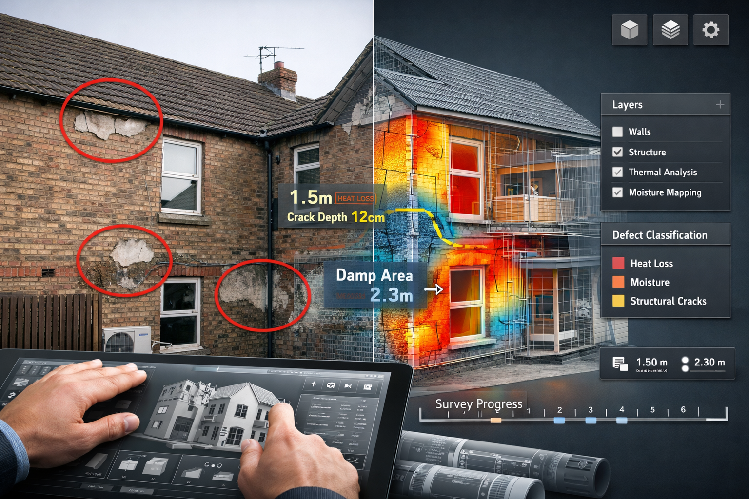
Immersive Visualization for Client Communication
Perhaps the most transformative aspect of 3D modeling is how it changes client communication. Traditional survey reports require clients to interpret written descriptions and translate 2D photographs into mental models of defect severity and location.
Modern 3D visualizations eliminate this interpretation barrier:
📱 Interactive web viewers allow clients to explore their property from any device without specialized software
🎨 Color-coded defect mapping uses intuitive visual language (red for urgent, amber for moderate, green for minor) to communicate priority
📏 Embedded measurements show exact dimensions, areas, and volumes associated with defects
🔄 Before/after scenarios illustrate proposed repairs and their visual impact on the property
This visual clarity empowers buyers during negotiations. When presenting a structural survey to a seller, showing a 3D model with color-coded defects and precise repair measurements carries far more weight than written descriptions alone.
Practical Applications: How Digital Tools Impact Real Building Surveys
Understanding the technology is one thing—seeing how it applies to real-world survey scenarios brings the value into sharp focus. Here are several practical applications where Digital Tools in Building Surveys: Laser Measurement, Drones and 3D Models for Defect Visualization in 2026 make a measurable difference.
Heritage Building Assessment
Historic properties present unique survey challenges. Irregular construction, non-standard dimensions, and fragile materials require careful documentation without causing damage. Digital tools excel in this context:
- Non-contact measurement preserves delicate surfaces and finishes
- Complete dimensional records capture ornate details and complex geometries
- Comparative analysis tracks deterioration over time for conservation planning
- Virtual access allows specialists worldwide to review conditions without site visits
Commercial Property Due Diligence
When acquiring commercial property portfolios, investors need rapid, comprehensive condition assessments across multiple buildings. Drone and laser technology enable:
- Accelerated survey timelines completing multi-building assessments in days rather than weeks
- Standardized reporting with consistent data quality across all properties
- Portfolio-level analytics identifying common defect patterns and maintenance priorities
- Capital expenditure forecasting based on precise defect quantification and measurement
Dispute Resolution and Expert Witness
Property disputes often hinge on precise measurement and objective evidence. Digital survey data provides:
- Irrefutable measurements that withstand legal scrutiny
- Time-stamped documentation establishing condition at specific dates
- Visual evidence that juries and judges can easily understand
- Comparative analysis showing changes over time or deviations from standards
This objective evidence proves particularly valuable in dilapidation surveys and boundary disputes where precise measurement is critical.
Pre-Purchase Negotiation Support
For residential buyers, digital survey tools transform the negotiation process:
Scenario: A buyer receives a survey identifying roof defects, structural movement, and damp penetration. Traditional report: written descriptions and photographs. Digital-enhanced report: 3D model showing exact defect locations, measurements, color-coded severity ratings, and embedded repair cost estimates.
The digital approach enables the buyer to:
- Quantify repair costs with precision based on measured quantities
- Prioritize negotiations focusing on the most significant defects
- Obtain competitive quotes by sharing accurate specifications with contractors
- Make informed decisions about whether to proceed, renegotiate, or withdraw
When comparing different types of survey, the addition of digital tools represents a significant value enhancement regardless of survey level chosen.
Selecting the Right Digital Tools for Your Survey Needs
Not every building survey requires the full suite of digital technologies. Understanding when and how to deploy these tools ensures cost-effective, appropriate investigation matched to property type and client objectives.
Matching Technology to Survey Objectives
Consider these factors when determining which digital tools add value:
Property Size and Complexity
- Small residential properties: Laser scanning for internal spaces, drone for roof/chimney
- Large commercial buildings: Full LiDAR survey, comprehensive drone mapping, complete BIM model
- Heritage properties: High-resolution laser scanning, photogrammetry for detailed documentation
Defect Type and Location
- Structural movement: Laser scanning for precise measurement and monitoring
- Roof defects: Drone survey with high-resolution imagery and thermal imaging
- Damp and moisture: Thermal imaging (ground and aerial), moisture meters, laser scanning for pattern analysis
- Hard-to-access areas: Drone inspection as primary investigation method
Client Requirements
- Residential buyers: Visual 3D models for understanding defect impact
- Commercial investors: BIM models for facility management integration
- Developers: As-built verification and construction monitoring
- Legal proceedings: Comprehensive documentation with verified measurements
Cost-Benefit Considerations
Digital survey tools represent an investment that should deliver proportionate value:
When Digital Tools Add Significant Value:
- ✅ Properties over £500,000 where repair costs could significantly impact negotiations
- ✅ Buildings with known access challenges (height, safety concerns, restricted areas)
- ✅ Commercial properties requiring ongoing facility management
- ✅ Heritage buildings needing detailed conservation records
- ✅ Properties with suspected structural issues requiring precise measurement
When Traditional Methods May Suffice:
- ⚠️ Simple, single-story buildings with full accessibility
- ⚠️ Properties where visual inspection reveals obvious, straightforward defects
- ⚠️ Budget-constrained surveys where basic reporting meets client needs
- ⚠️ Properties being demolished where detailed documentation isn't required
For guidance on which survey you need, consulting with a qualified surveyor helps match investigation scope to property characteristics and purchase objectives.
Future-Proofing Your Property Investment
Beyond immediate defect identification, digital survey data provides long-term value:
Baseline Documentation: 3D models and point clouds establish precise "as-is" conditions for future comparison, renovation planning, or insurance claims.
Facility Management Integration: BIM models created during purchase surveys can be enhanced with operational data, creating digital twins that optimize building management throughout ownership.
Regulatory Compliance: Accurate dimensional data supports planning applications, building regulation compliance, and accessibility assessments.
Resale Value: Comprehensive digital documentation enhances property marketing and provides transparency to future buyers.
Conclusion: Empowering Property Decisions Through Digital Innovation
Digital Tools in Building Surveys: Laser Measurement, Drones and 3D Models for Defect Visualization in 2026 represent far more than technological novelty—they fundamentally transform how property buyers, owners, and professionals understand building condition and make informed decisions. The evolution from basic photographs and written descriptions to immersive 3D visualizations backed by millimeter-precise measurements has shifted the balance of power in property transactions.
Buyers armed with laser-scanned measurements, drone-captured imagery, and interactive 3D defect models enter negotiations with concrete evidence rather than subjective opinions. Hidden issues in hard-to-reach areas—deteriorating chimneys, failing roof valleys, structural movement—are revealed with clarity that was simply impossible with traditional survey methods alone.
The integration of RTK and SLAM laser scanning delivers survey-grade accuracy while reducing site time by up to 70%. Drone-mounted LiDAR systems access dangerous or inaccessible areas safely and cost-effectively, capturing comprehensive data in single flights. Scan-to-BIM workflows transform raw data into parametric models that integrate seamlessly with design and facility management platforms, providing value long after the initial survey.
Taking Action: Next Steps for Property Buyers and Professionals
For Property Buyers:
- Request information about digital survey enhancements when commissioning a RICS Building Survey
- Ask whether drone inspection and laser scanning would add value given your property's characteristics
- Inquire about 3D visualization options that can help you understand defect severity and location
- Use digital survey data to obtain competitive repair quotes and strengthen negotiating position
For Property Professionals:
- Invest in digital survey capabilities or partner with specialists who provide these services
- Integrate point cloud and BIM workflows into standard survey delivery
- Develop client-friendly visualization methods that communicate defect information clearly
- Stay current with emerging technologies and best practices through continuing professional development
For Building Owners:
- Consider baseline digital surveys to establish property condition for future reference
- Use periodic drone surveys to monitor building condition and identify maintenance priorities early
- Leverage BIM models for renovation planning and facility management optimization
- Maintain digital documentation to support insurance claims, compliance, and future sale processes
The building survey industry has entered a new era where technology enhances rather than replaces professional expertise. The surveyor's trained eye for defect identification, understanding of building pathology, and ability to interpret significance remains irreplaceable—but when combined with digital tools that provide objective measurement, comprehensive access, and immersive visualization, the result is survey reporting that truly empowers confident decision-making.
For comprehensive survey services incorporating the latest digital technologies, contact our team to discuss how laser measurement, drone surveying, and 3D modeling can enhance your property assessment.
References
[1] Watch – https://www.youtube.com/watch?v=KHkeSpGzvC4
[2] Lidar Vs Photogrammetry – https://www.jouav.com/blog/lidar-vs-photogrammetry.html
[3] Drone Surveying – https://uavcoach.com/drone-surveying/
[4] Top Drones For Construction Surveying In 2025 – https://advexure.com/blogs/news/top-drones-for-construction-surveying-in-2025