Fewer than 15% of major UK development projects in 2024 incorporated comprehensive ecological baseline data before planning applications were submitted — a gap that regulators are now actively closing. As stricter environmental compliance requirements take hold in 2026, sustainability-focused surveying: using data to guide environmentally responsible development has moved from an optional best practice to a professional and legal imperative. Surveyors who once focused primarily on structural condition and market value are now expected to act as frontline environmental analysts, capturing ecological data before a single machine breaks ground.
This shift is not merely procedural. It reflects a fundamental change in how the built environment profession understands its responsibilities — to clients, to communities, and to ecosystems that cannot advocate for themselves.
Key Takeaways
- Sustainability-focused surveying integrates ecological data, remote sensing, and AI analytics into development planning before construction begins.
- Technologies including LiDAR, UAV drones, and satellite imagery allow surveyors to model environmental risks with unprecedented precision.
- RICS introduced a global professional standard for responsible AI use in surveying, effective March 2026, mandating data governance and risk management protocols.
- Indicator-based frameworks and structured decision-making tools help translate raw environmental data into actionable development guidance.
- Chartered surveyors who embed sustainability data into their assessments are better positioned to protect clients from regulatory risk and project delays.
Why Environmental Data Has Become Central to Modern Surveying
The traditional surveying brief — assess condition, estimate value, flag defects — remains important. But it no longer tells the full story of a site's development potential or risk profile. Environmental legislation, planning policy, and investor expectations have converged to demand something more rigorous.
In the UK, the Environment Act 2021 introduced mandatory Biodiversity Net Gain (BNG) requirements, meaning developers must demonstrate measurable ecological improvement as a condition of planning consent. This single policy change has made ecological baseline surveys a prerequisite rather than an afterthought. Surveyors who understand how to gather, interpret, and present environmental data are now central to the planning and development process [1].
The core challenge is timing. Environmental impacts are far easier and cheaper to address before development begins than after. A surveyor equipped with the right data tools can identify flood risk corridors, protected species habitats, soil contamination zones, and subsidence-prone ground conditions months before a planning application is submitted. That foresight protects clients from costly redesigns, enforcement action, and reputational damage.
For those considering a property assessment, understanding which survey you need is an important first step — and increasingly, that conversation must include environmental risk as a core component.
The Technology Stack Behind Sustainability-Focused Surveying
Sustainability-focused surveying: using data to guide environmentally responsible development depends on a suite of technologies that have matured rapidly over the past decade. Each tool captures a different layer of environmental intelligence, and the most effective surveys combine several of them.
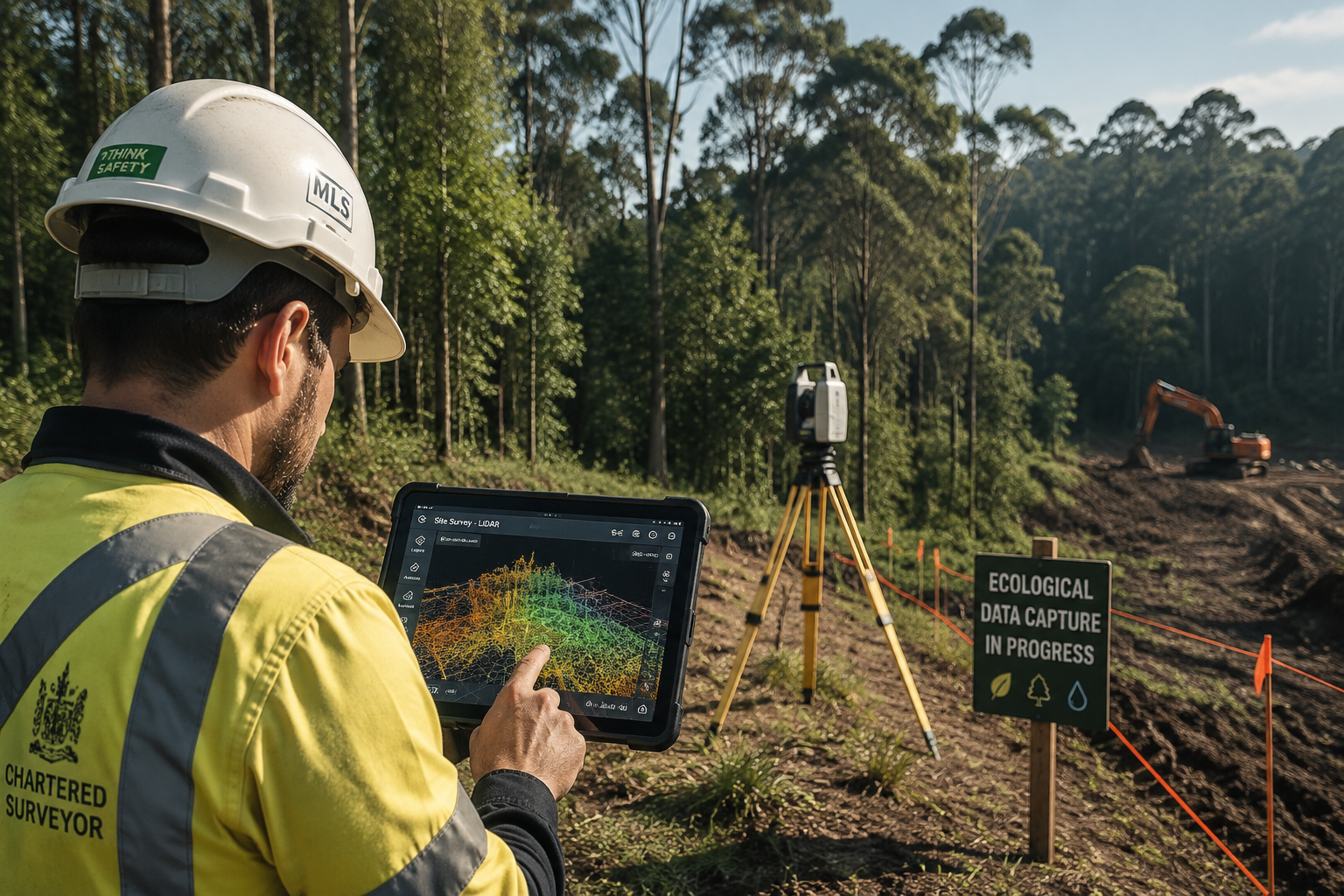
LiDAR and 3D Point Cloud Mapping
Light Detection and Ranging (LiDAR) technology generates detailed three-dimensional models of terrain, structures, and vegetation by emitting laser pulses and measuring their return times. In environmental surveying, LiDAR is used to:
- Assess ground subsidence risks and identify underground voids
- Map tree canopy cover and calculate green infrastructure value
- Model surface water flow paths and flood inundation extents
- Detect changes in ground elevation that may indicate unstable geology [2]
The resulting 3D point clouds give surveyors and planners a precise picture of how water, wind, and ecological systems interact with a given site. This level of detail was simply not achievable with traditional ground-based methods.
UAV Drone Surveys
Unmanned Aerial Vehicles (UAVs) have become essential instruments in environmental surveying. A single drone flight can cover hundreds of hectares in hours, capturing:
- High-resolution imagery for habitat classification
- Thermal data to identify heat loss, moisture ingress, and underground water movement
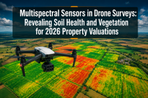
- Multispectral readings to assess vegetation health using indices like NDVI (Normalized Difference Vegetation Index)
- Flood risk zone mapping based on elevation and drainage pattern analysis [2]
For complex or large sites, drone surveys offer a cost-effective way to gather baseline ecological data that would take weeks to collect on foot. The speed advantage is particularly valuable when planning timelines are tight.
Satellite Remote Sensing
Satellite-based platforms provide something that ground surveys and drones cannot: temporal depth. By comparing satellite imagery across months or years, surveyors can track:
- Soil moisture fluctuations that signal drainage problems
- Vegetation loss or encroachment on protected ecological sites
- Cumulative environmental impacts from adjacent development projects
- Long-term erosion and land degradation trends [2]
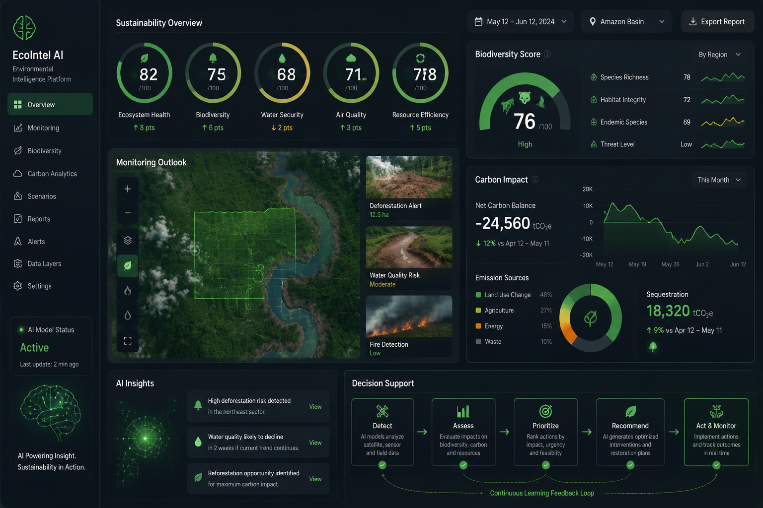
When combined with machine learning algorithms, satellite imagery can model sustainable development outcomes across entire regions, addressing the scarcity of ground-level data in rural or difficult-to-access areas [6].
| Technology | Primary Environmental Use | Key Advantage |
|---|---|---|
| LiDAR | Terrain modelling, subsidence detection | Sub-centimetre vertical accuracy |
| UAV Drones | Habitat mapping, thermal analysis | Rapid large-area coverage |
| Satellite Imagery | Long-term change detection | Historical temporal datasets |
| AI Analytics | Pattern recognition, risk forecasting | Processes vast datasets quickly |
| Ground Sensors | Real-time soil and water monitoring | Continuous live data streams |
AI-Powered Environmental Analytics
Artificial intelligence is now embedded in the surveying workflow at multiple points. Machine learning models can identify habitat types from drone imagery, flag anomalous subsidence patterns in LiDAR data, and predict flood risk probabilities from composite datasets.
Recognising this shift, the Royal Institution of Chartered Surveyors (RICS) introduced a global professional standard for the responsible use of AI in surveying, effective March 9, 2026. The standard mandates clear policies on data governance, AI system oversight, and risk management — acknowledging that AI is no longer experimental but mainstream in professional practice [2].
"The surveyor of 2026 is as much a data analyst as a physical inspector. The ability to interpret AI-generated environmental models is now a core professional competency."
From Raw Data to Responsible Decisions: The Analytical Framework

Capturing environmental data is only half the challenge. The more demanding task is translating that data into decisions that genuinely guide environmentally responsible development. This is where sustainability-focused surveying: using data to guide environmentally responsible development distinguishes itself from simple data collection.
Indicator-Based Sustainability Assessment
Researchers have developed analytical frameworks that translate Earth observation data into sustainable development indicators — measurable metrics that track progress toward ecological and social goals [3]. In a surveying context, these indicators might include:
- Percentage of site with permeable surface coverage
- Biodiversity Net Gain score (expressed as habitat units)
- Surface water runoff coefficient before and after development
- Carbon sequestration capacity of retained vegetation
- Proximity and connectivity to designated ecological sites
Engaging stakeholders — including local communities, ecologists, and planning authorities — in selecting and prioritising these indicators improves both the quality of monitoring and the legitimacy of development decisions [4]. A surveyor who presents findings using recognised indicator frameworks is far more likely to achieve productive dialogue with planning officers than one who relies on narrative descriptions alone.
Structured Decision Making
Structured Decision Making (SDM) is an organised framework that incorporates differing stakeholder values and evaluates development alternatives against defined environmental criteria. Despite being well-suited to ecological restoration and development planning, SDM remains underused in practice [5].
The SDM process typically involves:
- Defining the problem — what environmental outcomes are at stake?
- Identifying objectives — what does success look like for all stakeholders?
- Generating alternatives — what development configurations are possible?
- Evaluating consequences — what does the data predict for each alternative?
- Making a decision — which option best balances development goals with environmental protection?
Surveyors who can facilitate this process add substantial value beyond the technical assessment itself. They become advisors who help clients navigate genuinely complex trade-offs.
Water and Drainage Data Systems
Effective environmental management of development sites requires data systems that are sufficient, accessible, and useful to decision-makers [7]. Water management is a particularly critical area. Poor drainage design is one of the most common causes of post-construction environmental damage, from localised flooding to watercourse contamination.
A thorough drainage survey conducted before development begins can identify existing drainage constraints, model the impact of increased impermeable surfaces, and inform sustainable drainage system (SuDS) design. This kind of pre-development intelligence is far more cost-effective than retrofitting drainage solutions after problems emerge.
Renewable Energy and Ecological Trade-offs
Sustainability is not always straightforward. The rapid expansion of utility-scale solar energy, for example, requires careful evaluation of trade-offs between land use, energy generation, and ecological impact. Understanding how species respond to habitat modification and considering long-term ecological consequences are essential for genuinely sustainable development decisions [8].
A surveyor assessing a site proposed for solar installation must consider not just the structural and planning dimensions but also the ecological baseline. Solar panel roof engineer calculations are one element of this assessment, but they sit within a broader environmental context that requires data-driven analysis.
The Surveyor's Expanded Role in Sustainable Development
The practical implications of this data-driven shift are significant for how surveyors work and how clients should select their professional advisors.
Building Surveys with Environmental Depth
A building survey conducted by a chartered surveyor today should incorporate more than structural condition. Environmental risk factors — including flood zone classification, contaminated land registers, proximity to protected habitats, and energy performance data — are now material to any comprehensive property assessment.
For commercial properties, an RICS commercial building survey that ignores environmental risk leaves clients exposed to regulatory liability, insurance complications, and reduced asset value. Investors and lenders are increasingly requiring evidence of environmental due diligence before committing capital.
Asbestos and Hazardous Materials
Environmental responsibility in surveying also extends to legacy hazardous materials. Asbestos surveys are a legal requirement before demolition or major refurbishment of buildings constructed before 2000, and they represent a direct intersection of environmental protection and occupational health. The data gathered in these surveys informs safe removal plans and prevents harmful fibres from entering the environment during construction.
Property Certification and Compliance
Property certification services are increasingly tied to environmental performance metrics. Energy Performance Certificates (EPCs), BREEAM ratings, and biodiversity assessments are all forms of environmental data that inform planning decisions, mortgage lending, and investment valuations.
Surveyors who understand how to gather and interpret this certification data are better placed to advise clients on compliance pathways and improvement strategies.
Valuation in an Environmentally Conscious Market
Environmental factors are now material to property valuation. Flood risk, energy efficiency, contamination history, and proximity to green infrastructure all affect market value and insurance costs. Understanding the factors of valuation in this context requires surveyors to integrate environmental data alongside traditional market comparables.
Properties with strong environmental credentials — low carbon footprint, good EPC ratings, sustainable drainage — are increasingly commanding premium prices in both residential and commercial markets. Conversely, properties with unresolved environmental liabilities face growing valuation discounts as buyers and lenders become more sophisticated in their risk assessments.
Barriers to Adoption and How to Overcome Them
Despite the clear benefits, sustainability-focused surveying faces real barriers in practice.
Data quality and consistency remain a challenge. Environmental datasets from different sources — satellite platforms, local authority records, ecological surveys — are not always compatible or current. Surveyors must develop skills in data validation and gap analysis.
Cost perception is another obstacle. Clients accustomed to standard surveys may resist the additional cost of drone flights, LiDAR scans, or specialist ecological assessments. The counter-argument — that these costs are trivial compared to the expense of a failed planning application or post-construction remediation — is compelling but requires clear communication.
Professional development is essential. The RICS AI standard introduced in March 2026 is one signal that the profession is evolving rapidly. Surveyors who invest in understanding environmental data tools, remote sensing platforms, and AI analytics will be better positioned than those who rely on traditional methods alone.
Stakeholder engagement must be built into the process from the outset. Environmental data is most valuable when it informs dialogue between developers, planners, ecologists, and communities. Surveyors who can facilitate that dialogue — presenting complex data in accessible formats — add disproportionate value to the development process.
Conclusion
Sustainability-focused surveying: using data to guide environmentally responsible development is not a trend that will pass. It is the new baseline for professional practice in a regulatory environment that demands ecological accountability before, during, and after construction.
Actionable next steps for developers, investors, and property owners in 2026:
- Commission environmental baseline surveys early — before planning applications are prepared, not after they are submitted.
- Require drone, LiDAR, or satellite data components in survey briefs for sites larger than one hectare or in ecologically sensitive locations.
- Ask surveyors to present findings using recognised sustainability indicator frameworks, not just narrative reports.
- Engage a chartered surveyor with demonstrable experience in environmental data interpretation and RICS compliance.
- Treat environmental due diligence as an investment in project certainty, not a cost to be minimised.
The surveyors who will define the next decade of responsible development are those who understand that a site's environmental data is not a constraint on ambition — it is the foundation on which genuinely sustainable, resilient, and valuable development is built.
References
[1] Sustainability Driven Surveying Using Tech To Assess Environmental Impacts – https://www.canterburysurveyors.com/blog/sustainability-driven-surveying-using-tech-to-assess-environmental-impacts/?utm_source=openai
[2] Sustainability In Surveying Using Tech To Assess Environmental Impacts And Regulations – https://www.canterburysurveyors.com/blog/sustainability-in-surveying-using-tech-to-assess-environmental-impacts-and-regulations/?utm_source=openai
[3] onlinelibrary.wiley – https://onlinelibrary.wiley.com/doi/full/10.1002/sd.1908?utm_source=openai
[4] An Indicator Based Approach To Sustainable Management Of Natural – https://impact.ornl.gov/en/publications/an-indicator-based-approach-to-sustainable-management-of-natural-/?utm_source=openai
[5] Structured Decision Making Remains Underused Ecological Restoration Despite – https://www.usgs.gov/publications/structured-decision-making-remains-underused-ecological-restoration-despite?utm_source=openai
[6] pubmed.ncbi.nlm.nih.gov – https://pubmed.ncbi.nlm.nih.gov/33737462/?utm_source=openai
[7] Making A Water Data System Responsive To Information Needs Of Dec – https://impact.ornl.gov/en/publications/making-a-water-data-system-responsive-to-information-needs-of-dec/?utm_source=openai
[8] Sustainability Utility Scale Solar Energy Critical Ecological Concepts – https://www.usgs.gov/publications/sustainability-utility-scale-solar-energy-critical-ecological-concepts?utm_source=openai