A property that sold for 12% above asking price in Manchester in early 2026 had one distinguishing factor over comparable listings on the same street: a current, professionally certified land survey. The seller could prove exactly what they owned, what could be built on it, and that no boundary disputes lurked in the title. That combination of clarity and credibility is precisely how land surveys boost property value across boundaries, development potential, and market edge — and it is a dynamic that plays out in residential, commercial, and mixed-use markets every day.
Understanding how land surveys boost property value: boundaries, development potential, and market edge is no longer optional knowledge for property owners, developers, or investors. In 2026, buyers are better informed, lenders are more cautious, and competition for well-documented land is intensifying. A survey is not merely a legal formality — it is a strategic asset.
Key Takeaways
- Accurate boundary surveys eliminate costly disputes and give buyers confidence in what they are purchasing.
- Surveys reveal zoning opportunities and development potential that can dramatically increase a parcel's market value.
- Professionally certified surveys signal trustworthiness to buyers, lenders, and insurers, accelerating sales and improving terms.
- Physical characteristics such as terrain, soil quality, access, and utility connections — all identified through surveys — directly influence appraised value.
- Land assemblage strategies depend on precise survey data to unlock premium value from combined parcels.

Why Boundary Clarity Drives Property Value
Every property transaction rests on a fundamental question: what exactly is being bought or sold? Without a current survey, that question is answered by assumption — and assumptions cost money.
Boundary disputes are more common than most owners realise. Encroachments from fences, outbuildings, driveways, or landscaping can shave thousands from a sale price or halt a transaction entirely. When a survey defines the legal boundary with precision, it removes that uncertainty. Buyers pay more for certainty. Lenders lend more confidently against it.
Accurate parcel data — including ownership details, boundary lines, and building footprints — is foundational to assessing property value and development potential [3]. Services that map these boundaries in detail have become standard tools for serious investors and developers because they eliminate the guesswork that otherwise inflates risk premiums.
The Cost of Boundary Ambiguity
Consider what happens when boundaries are unclear:
| Consequence | Typical Impact |
|---|---|
| Boundary dispute litigation | Costs of £5,000–£50,000+ |
| Sale fall-through | Lost time, relisting costs |
| Reduced lender confidence | Lower loan-to-value ratios |
| Buyer negotiation leverage | Price reductions of 5–15% |
| Insurance complications | Higher premiums or declined cover |
A professionally conducted survey eliminates most of these risks before they materialise. That is a direct, quantifiable contribution to net property value.
Encroachments, Easements, and Rights of Way
Beyond simple boundary lines, surveys identify easements — rights that third parties hold over a property — and encroachments, where structures cross legal lines. ALTA/NSPS surveys, widely used in commercial real estate transactions, are specifically designed to surface these issues [5]. They document improvements, easements, and potential encroachments in a format that satisfies title insurers and lenders simultaneously.
For residential properties, understanding where a right of way runs across a garden, or whether a neighbour's extension crosses the legal boundary, can be the difference between a smooth sale and a collapsed one. Buyers who receive this information upfront trust the transaction — and trust translates into willingness to pay.
"Clarity of ownership is the foundation of property value. A survey does not create that clarity — it reveals it."
How Land Surveys Reveal Development Potential and Market Edge
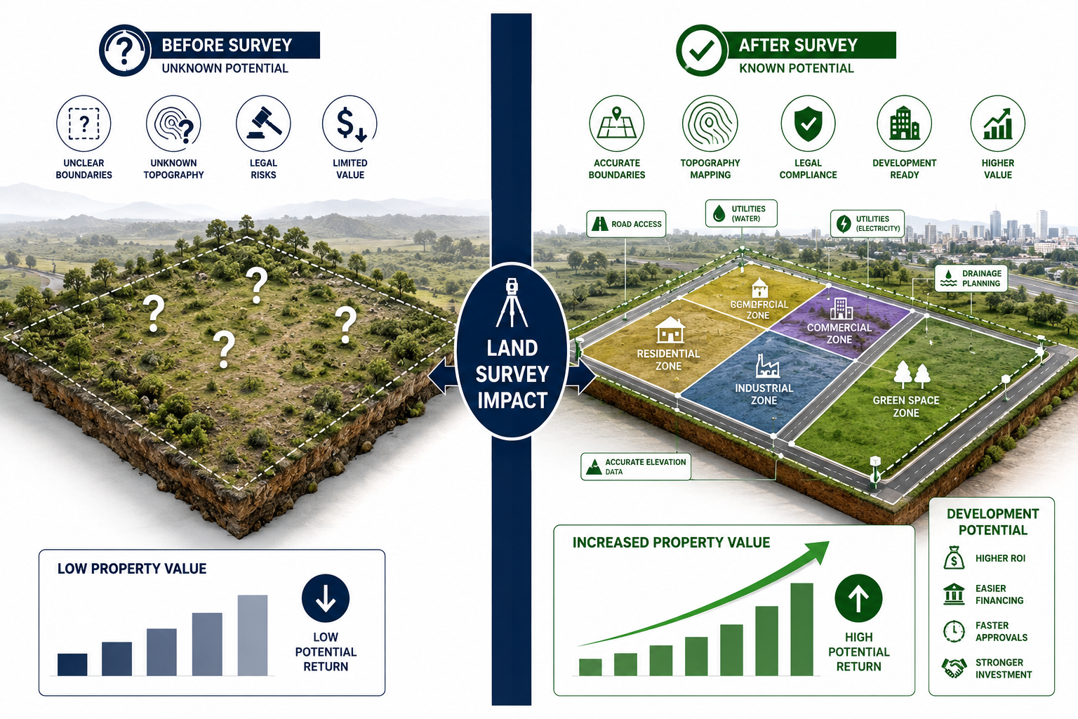
The most significant financial uplift from a land survey often comes not from confirming what already exists, but from revealing what is possible. Understanding how land surveys boost property value through development potential is where professional survey data moves from defensive tool to offensive strategy.
Zoning Opportunities Hidden in Plain Sight
Many landowners sit on parcels with unrealised planning and zoning potential. A thorough land planning survey reveals total and usable acreage, access issues, terrain challenges, and environmental constraints — information that is essential to avoid costly surprises during development [4]. More importantly, it identifies what portion of a site is genuinely buildable.
Zoning classifications, overlay districts, and permitted development rights are all tied to precise parcel data. A survey that accurately defines a boundary may reveal that a property straddles two zoning categories, opening the door to mixed-use development that a simple title search would never uncover. That single discovery can multiply a site's value.
Platforms using geospatial intelligence now deliver rapid feasibility reports that score environmental risks, infrastructure availability, and resource potential for individual parcels [2]. These tools are increasingly used by developers before committing to acquisition — and they rely entirely on accurate survey data as their input.
Physical Characteristics That Surveys Quantify
Physical characteristics of land have a direct and measurable effect on value. Parcel shape, terrain gradient, soil quality, and drainage patterns all influence what can be built and at what cost [6]. A survey quantifies these factors with precision that no desktop assessment can match.
Key physical factors that surveys reveal include:
- Usable versus total acreage — steep slopes, flood zones, or protected areas reduce buildable land
- Soil bearing capacity — critical for structural foundations and drainage systems
- Access points — properties with direct road access command higher values; landlocked parcels require additional investment [6]
- Utility connections — proximity to mains water, gas, electricity, and drainage directly affects development cost and therefore land value
- Topographic features — level sites are generally more valuable for development than irregular terrain
For agricultural land, soil surveys and GIS mapping provide insights into soil quality and land use patterns that determine agricultural potential and inform development decisions [9]. A parcel that appears marginal on paper may, after a proper soil survey, prove highly productive — or vice versa.
Land Assemblage: Multiplying Value Through Survey Precision
One of the most powerful strategies in property development is land assemblage — combining adjacent parcels to create a larger, more developable tract [7]. This process depends entirely on precise survey data.
When boundary lines are clearly established across multiple parcels, assembling them becomes legally straightforward. Title issues are pre-empted. Overlaps and gaps between parcels are identified and resolved before they become deal-breakers. The result is a combined site that is worth considerably more than the sum of its individual parts — a concept known as the "marriage value" premium.
Without accurate surveys, assemblage attempts frequently stall over disputed boundaries, unresolved easements, or access rights that were never properly documented. Professional survey data removes these obstacles and enables developers to move quickly — a competitive advantage in any market.
For commercial property owners and developers, working with specialists in commercial property surveying ensures that assemblage and development strategies are built on legally sound, professionally verified foundations.
Surveys as a Market Signal: Trust, Speed, and Better Terms

Beyond the technical data they provide, land surveys function as a powerful market signal. In 2026, buyers, lenders, and insurers are increasingly sophisticated. A seller who presents a current, professionally certified survey communicates something that no marketing brochure can: this owner knows what they have, and they have nothing to hide.
How Surveys Accelerate Sales
Properties with current surveys typically move through the conveyancing process faster. Solicitors spend less time chasing boundary confirmations. Lenders process valuations more smoothly. Buyers feel less need to negotiate protective price reductions against unknown risks.
Speed matters in property markets. A transaction that completes two months faster than average saves carrying costs, avoids the risk of a buyer withdrawing, and reduces the window during which market conditions can shift. That time value is real money.
Understanding which survey you need for your specific property type is the first practical step toward capturing these benefits. The right survey for a residential boundary dispute differs from the right survey for a commercial development site.
Lender Confidence and Loan Terms
Mortgage lenders and commercial finance providers use survey data to determine loan-to-value ratios and lending terms. A property with clear boundaries, no encroachments, and documented development potential presents a lower risk profile. Lower risk typically means better terms — higher loan-to-value ratios, lower interest rate margins, or faster approval.
A Red Book valuation from an RICS-registered surveyor, supported by accurate survey data, carries significant weight with lenders. It provides an independent, professionally verified assessment of market value that lenders can rely on with confidence.
For commercial assets, a professional valuation of commercial property that incorporates survey findings can unlock financing that would otherwise be unavailable or offered only on restrictive terms.
Insurance and Risk Management
Insurers price premiums based on risk. A property with ambiguous boundaries, undisclosed easements, or unresolved encroachments carries higher risk — and insurers price that risk accordingly. A current survey reduces that uncertainty, which can translate directly into lower insurance premiums or access to cover that was previously unavailable.
For properties where structural issues are a concern, combining a land survey with a building survey provides a comprehensive picture of both the land and the structure — a combination that satisfies both lenders and insurers.
Online Valuation Tools and Their Limitations
Online land value estimators provide useful preliminary assessments based on market trends and property characteristics [8]. Comprehensive land assessment platforms evaluate utility access, zoning, and environmental risks to help investors identify potential red flags before committing resources [1]. These tools are valuable for initial screening, but they are only as accurate as the underlying parcel data they consume.
When that underlying data comes from a professional survey, the estimates become meaningfully more reliable. When it does not, the gap between estimated and actual value can be substantial — and that gap is always a risk for the buyer.
Choosing the Right Survey for Maximum Value Impact
Not all surveys serve the same purpose, and selecting the right type is critical to capturing the value benefits described above.
| Survey Type | Best Used For | Value Impact |
|---|---|---|
| Boundary survey | Resolving or preventing disputes | Removes discount for uncertainty |
| Topographic survey | Development feasibility | Reveals buildable area and constraints |
| ALTA/NSPS survey | Commercial transactions | Satisfies lenders and title insurers |
| Land planning survey | Pre-development due diligence | Identifies zoning and access opportunities |
| Soil/GIS survey | Agricultural and development land | Quantifies productive potential |
Working with RICS-certified chartered surveyors ensures that survey outputs meet the professional standards required by lenders, insurers, and planning authorities. RICS accreditation is not a formality — it is the benchmark that makes survey data credible and actionable in the market.
For property owners uncertain about structural issues that may affect value, a structural survey can identify defects before they become negotiating leverage for buyers. Similarly, properties with suspected subsidence benefit from a subsidence survey that either confirms the risk or provides evidence to refute it — both outcomes having clear value implications.
Conclusion: Actionable Steps to Capture Survey-Driven Value
The evidence is consistent and compelling: how land surveys boost property value — across boundaries, development potential, and market edge — is not theoretical. It is measurable, repeatable, and available to any property owner willing to invest in professional survey work.
Actionable next steps for property owners and investors in 2026:
-
Commission a boundary survey before listing. Eliminate the discount buyers apply for boundary uncertainty and give solicitors the documentation they need to move quickly.
-
Conduct a land planning survey before any development decision. Understanding total usable acreage, access, terrain, and environmental constraints before committing capital is essential due diligence.
-
Use survey data to support your valuation. A Red Book valuation backed by accurate survey data carries more weight with lenders and buyers than an estimate based on comparable sales alone.
-
Consider assemblage opportunities. If adjacent parcels are available, precise survey data is the prerequisite for unlocking marriage value premiums.
-
Work exclusively with RICS-accredited professionals. Survey data is only as valuable as its credibility. RICS certification ensures that outputs are accepted by lenders, insurers, and planning authorities.
-
Combine survey types for comprehensive coverage. A boundary survey paired with a building survey and a professional valuation provides the most complete picture of a property's true market position.
The cost of a professional survey is almost always a fraction of the value it protects or unlocks. In a competitive property market, that is not an expense — it is an investment with a measurable return.
References
[1] landgauge – https://landgauge.com/?utm_source=openai
[2] snapshot.land – https://snapshot.land/?utm_source=openai
[3] Property Boundaries – https://id.land/product/property-boundaries?utm_source=openai
[4] Complete Guide To Land Planning Surveys – https://thelandsurveyingcompany.com/land-survey/complete-guide-to-land-planning-surveys/?utm_source=openai
[5] What Is Alta Survey – https://www.surveyalta.com/resources/what-is-alta-survey?utm_source=openai
[6] How To Appraise Land Value Methods And Key Factors – https://legalclarity.org/how-to-appraise-land-value-methods-and-key-factors/?utm_source=openai
[7] Land Assemblage How Combining Parcels Creates Value – https://legalclarity.org/land-assemblage-how-combining-parcels-creates-value/?utm_source=openai
[8] Land Value Estimator Free Land Worth – https://www.landzero.com/land-value-estimator-free-land-worth/?utm_source=openai
[9] acrevalue – https://www.acrevalue.com/?utm_source=openai