{"cover":"Professional landscape format (1536×1024) hero image with bold text overlay: 'Preventing Neighbour Disputes: A Surveyor's Guide to Boundaries, Rights of Way and Encroachments in England and Wales' in extra large 70pt white bold sans-serif font with dark drop shadow, centered upper third composition. Background shows a semi-detached English residential street with a RICS chartered surveyor in hi-vis vest using a total station theodolite on a tripod, measuring a garden boundary line between two brick houses, overcast natural daylight, green hedgerows and timber fence panels visible. Color palette: deep navy blue, white text, amber accent stripe. Magazine cover aesthetic, editorial quality, high contrast, photorealistic.","content":["Landscape format (1536×1024) editorial illustration showing a split-scene comparison: left side depicts an English suburban garden with an encroaching timber fence built 300mm over the legal boundary line, annotated with red dashed overlay line and measurement callout; right side shows a RICS surveyor at a desk reviewing HM Land Registry title plans and conveyance documents under a desk lamp, with a topographic survey printout spread across the table. Warm interior lighting contrasts with outdoor daylight. Professional infographic style, photorealistic, detailed architectural setting.","Landscape format (1536×1024) aerial drone-perspective photograph of a row of English terraced houses with party walls clearly visible, one property undergoing a rear extension with scaffolding erected right on the boundary line. A Party Wall Act notice document is superimposed in the foreground with visible text sections highlighted in yellow. A surveyor in a hard hat and RICS-branded jacket stands at ground level reviewing a Schedule of Condition clipboard. Overcast English sky, brick and render facades, realistic depth of field, editorial documentary style.","Landscape format (1536×1024) courtroom-adjacent scene showing a professional mediation table in a neutral meeting room: two property owners seated opposite each other, a RICS boundary surveyor standing at the head of the table presenting a large annotated site plan on an easel showing a right of way corridor marked in blue across a residential property. Legal folders, a gavel, and a Pre-Action Protocol checklist document are visible on the table. Natural window light, professional interior, photorealistic editorial quality, cool neutral color palette."]
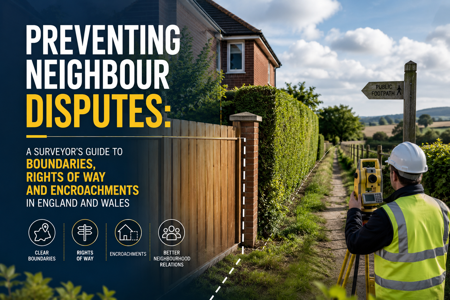
Boundary disputes cost English and Welsh homeowners an estimated £15,000 to £100,000 each in legal fees when cases reach the First-tier Tribunal (Property Chamber) — and the majority begin with something as mundane as a fence post, a driveway edge, or a rear extension built "on the line." This guide to preventing neighbour disputes covers boundaries, rights of way and encroachments across England and Wales, explaining precisely how a chartered surveyor's early involvement can stop a neighbourly disagreement from becoming a six-figure legal battle.
Key Takeaways
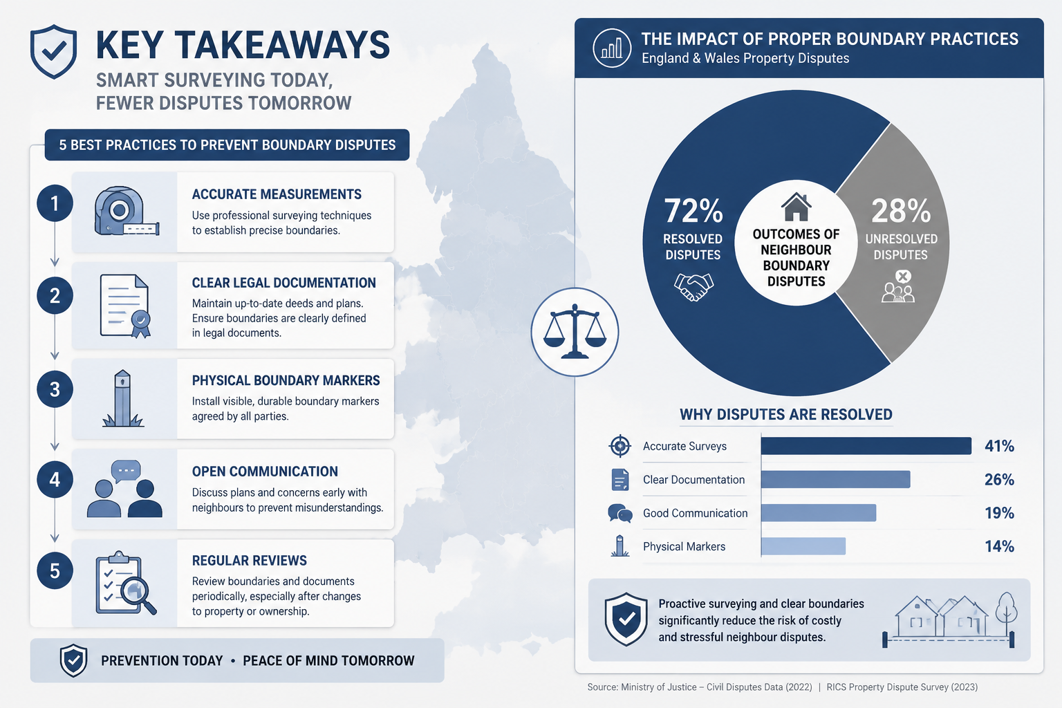
- Most boundary and encroachment disputes can be prevented by commissioning a topographic or boundary survey before purchasing or building, not after conflict has already started.
- HM Land Registry title plans are drawn to a general boundary rule and are not precise enough on their own to determine exact legal boundaries — a specialist survey is always required.
- The Party Wall etc. Act 1996 provides a statutory framework that protects both building owners and neighbours; ignoring it creates significant legal and financial exposure.
- Courts and tribunals expect parties to follow the Pre-Action Protocol for Property Disputes, including attempting mediation; failing to do so can result in adverse costs orders even for the winning party.
- Written boundary agreements, when properly drafted and registered as a determined boundary under Land Registration Rules 2003, provide the strongest long-term protection against future disputes.
Why Boundaries Are So Frequently Misunderstood in England and Wales
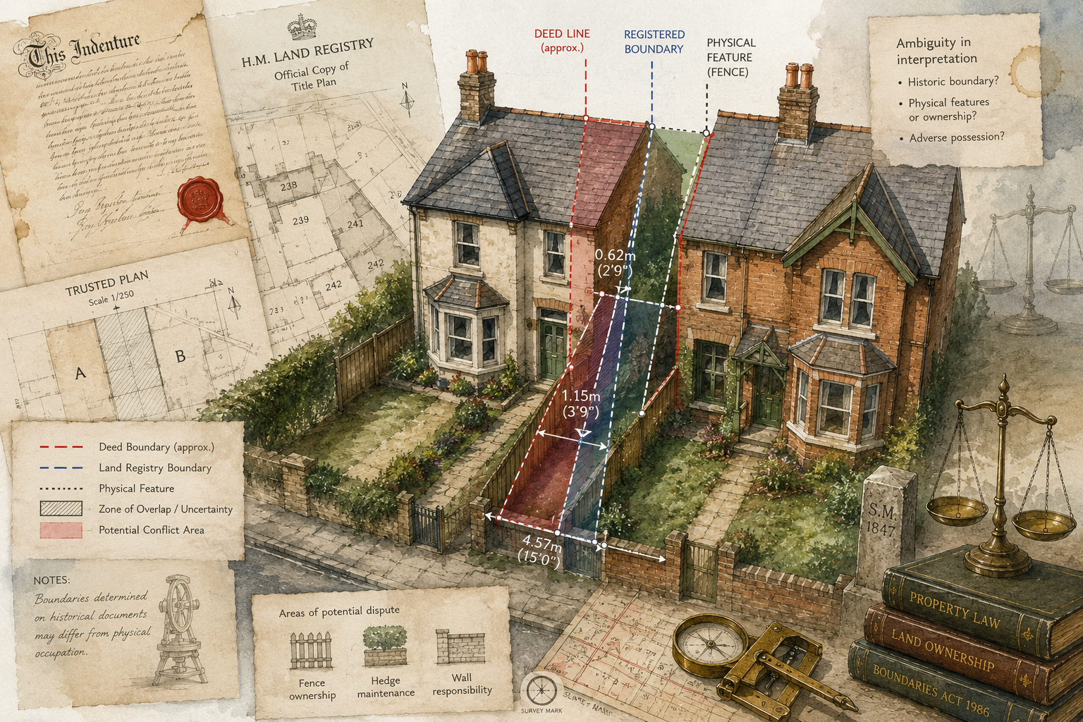
The root cause of most neighbour disputes in England and Wales is a widely misunderstood legal principle: the general boundary rule. Under this rule, HM Land Registry title plans — the coloured maps most homeowners treat as definitive — show only the general position of a boundary, not its precise legal line [3]. The red edging on a registered title plan is typically drawn at a scale of 1:1250 (urban) or 1:2500 (rural), meaning a line width on the plan can represent anywhere from 0.5 to 2.5 metres on the ground [10].
This matters enormously in practice. A homeowner who erects a close-board fence using the title plan as their only guide may inadvertently encroach by 200–400 mm on a neighbour's land. At street level that gap is barely noticeable; in legal terms it is a trespass.
The Three Most Common Triggers
| Trigger | How It Arises | Typical Cost if Litigated |
|---|---|---|
| Fence or wall repositioned during renovation | Contractor uses visual estimate rather than survey | £20,000–£60,000 |
| Rear extension built to the boundary | Planning drawings not checked against title | £30,000–£100,000 |
| Driveway widened or block-paved | Assumes ownership of "waste" land beside highway | £15,000–£40,000 |
Each of these scenarios is preventable. The solution in every case is the same: instruct a chartered surveyor to carry out a measured boundary survey before work begins, not after the dispute has crystallised [3].
"Resolve boundary ambiguities before exchange of contracts and share survey information with neighbours to reach written agreements — this single step reduces litigation risk more than any other measure." — RICS Consumer Guidance [3]
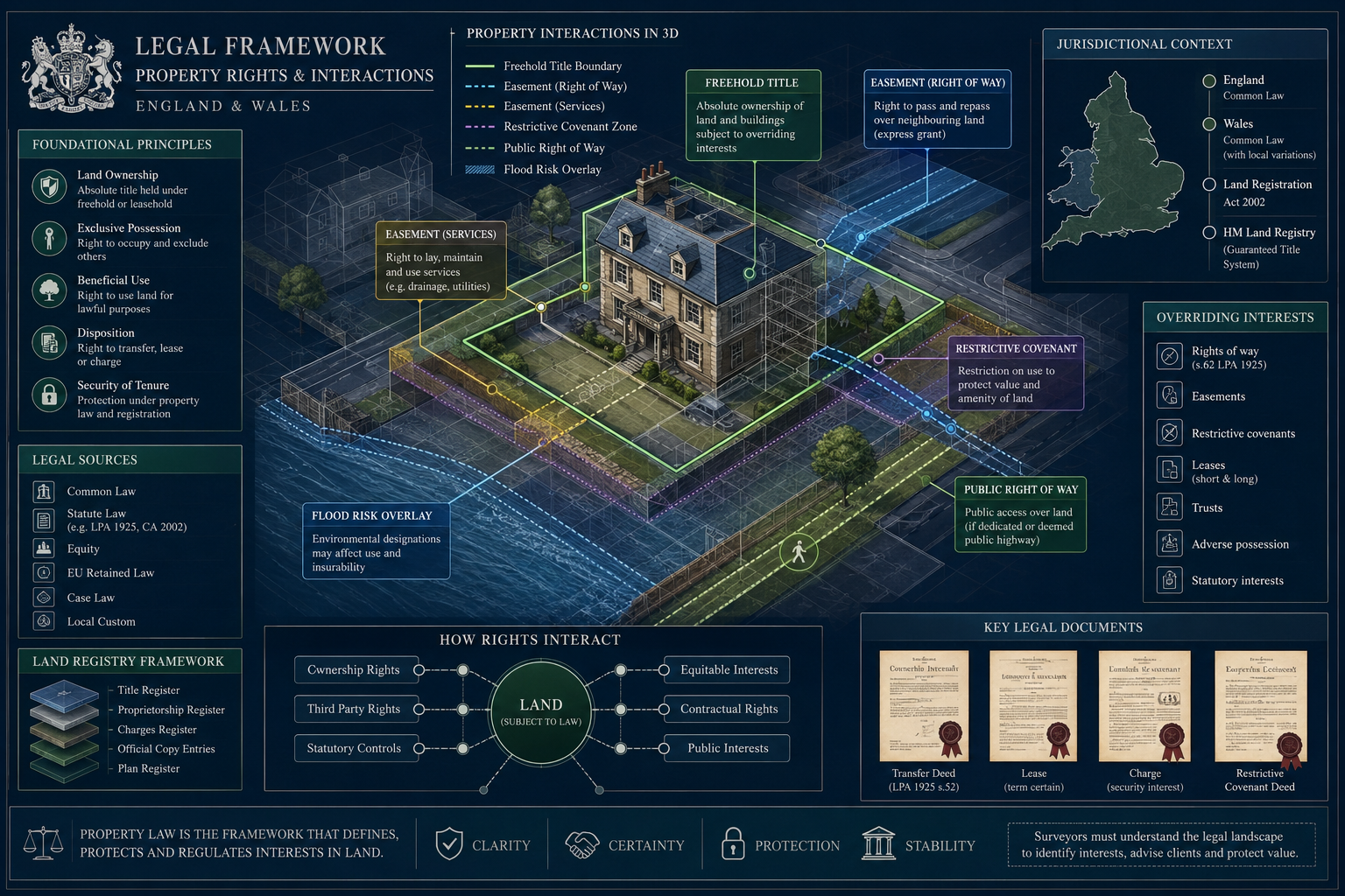
Understanding the Legal Framework: What Surveyors Must Know
The General Boundary Rule and How to Override It
As noted above, registered title plans are indicative only. To establish a determined boundary — one that is legally precise and registered — a surveyor must produce a plan showing the exact boundary line referenced to permanent physical features, with all measurements accurate to ±10 mm, taken horizontally from at least two fixed points [10]. This plan is then submitted to HM Land Registry under rule 122 of the Land Registration Rules 2003, converting the agreed line into a determined boundary entry on the register [10].
The process requires both neighbouring owners to agree on the line, execute appropriate transfers or boundary agreements, and jointly apply to the Land Registry. Once registered, the determined boundary provides a level of certainty that makes future litigation almost impossible to sustain [10].
The Party Wall etc. Act 1996
Any work that involves a party wall, a party fence wall, or excavations within 3 or 6 metres of a neighbouring structure is governed by the Party Wall etc. Act 1996 [7]. The Act requires the building owner to serve formal notice before commencing work. Failure to serve notice does not make the work unlawful, but it removes the statutory protections the Act provides and exposes the building owner to injunctions and damages claims [7].
For a detailed breakdown of what happens when a neighbour carries out works without following the Act, see the guidance on works carried out without a party wall agreement. Understanding what constitutes a party wall dispute is equally important before any building work near a shared structure begins.
A key practical tool under the Act is the Schedule of Condition — a photographic and written record of the adjoining owner's property taken before work starts. This document protects both parties by providing an agreed baseline against which any alleged damage can be assessed. Guidance on preparing a Schedule of Condition explains the process in full.
Rights of Way and Easements
A right of way is a legal right for one party to pass over another's land. Rights of way can be:
- Express — granted in a conveyance or transfer deed
- Implied — arising from necessity or common intention
- Prescriptive — acquired through 20 years of open, continuous, and unchallenged use
Encroachment on a right of way — for example, erecting a gate, planting a hedge, or extending a building across a footpath — can constitute an actionable interference [1]. The affected party can seek an injunction, damages, or both. Surveyors investigating rights of way disputes must examine the original conveyance documents, any Land Registry entries, and the physical evidence on site [5].
The Surveyor's Toolkit: Evidence, Surveys and Pre-Action Steps
Preventing neighbour disputes through a surveyor's approach to boundaries, rights of way and encroachments depends on assembling the right evidence at the right time. The following workflow reflects current 2026 best practice.
Step 1 — Gather All Title and Conveyance Documents
The starting point is always the paper trail. A surveyor should obtain:
- HM Land Registry official copies of the title register and title plan for both properties
- Pre-registration conveyances and transfers — often held by solicitors or the Land Registry as filed documents
- Deeds plans attached to historic conveyances, which may show boundary features in greater detail than the modern title plan
- Ordnance Survey base mapping at the largest available scale
Historic conveyances frequently contain verbal descriptions of boundaries ("bounded on the north by a brick wall belonging to the vendor") that, read alongside a surveyor's measured survey, can resolve ambiguity that the title plan alone cannot [4].
Step 2 — Commission a Topographic or Boundary Survey
RICS guidance is clear: where the legal boundary is unclear, commission a topographic survey [3]. A topographic survey uses a total station or GNSS equipment to capture the precise position of all physical features — walls, fences, hedges, kerbs, manholes — to sub-centimetre accuracy. The surveyor then overlays the title plan on the survey data, identifying any discrepancy between the registered general boundary and the physical features on the ground.
This survey forms the evidential backbone of any boundary negotiation or dispute. Without it, parties are arguing about lines on a map that were never intended to be precise [3].
For homebuyers, a homebuyer survey or a Level 3 building survey will flag boundary anomalies, encroachments and rights of way issues as part of its scope — making pre-purchase the ideal moment to identify problems before they become the new owner's liability.
Step 3 — Photographic and Historical Evidence
Physical evidence on site can be decisive. Surveyors should document:
- The position and condition of all boundary features — walls, fences, hedges, ditches
- Encroachments — structures, paving, vegetation crossing the boundary line
- Evidence of long use — worn paths, established planting, historical photographs
Aerial photography from sources such as the Getmapping archive or Google Earth's historical imagery can demonstrate when a fence was moved or when a structure was built, providing powerful evidence in any dispute [5].
Step 4 — Follow the Pre-Action Protocol
Before any court or tribunal proceedings are issued, parties to a boundary or encroachment dispute must follow the Pre-Action Protocol for Property Disputes. This requires:
- Sending a detailed letter of claim setting out the factual and legal basis of the claim
- Providing copies of all supporting evidence, including surveyor reports
- Allowing a reasonable response period (typically 14–28 days)
- Genuinely attempting alternative dispute resolution (ADR) — mediation, expert determination, or a without-prejudice meeting
Failure to follow the Protocol — for example, by refusing to share surveyor reports or declining mediation without good reason — can result in adverse costs orders even if the refusing party ultimately wins the case [5]. In 2026, courts are applying these sanctions more consistently than ever, making early ADR not just good practice but a financial necessity.
Preventing Neighbour Disputes: Practical Scenarios and Surveyor Solutions
Scenario 1 — The Fence Built "On the Line"
A homeowner in a semi-detached property replaces a dilapidated timber fence during a garden renovation. The contractor positions the new fence using the title plan printed from the Land Registry portal. Six months later, the neighbour commissions a topographic survey and discovers the new fence encroaches by 350 mm along a 12-metre run — a total encroachment of 4.2 square metres.
Surveyor's solution: Had a boundary survey been commissioned before the fence was erected, the encroachment would never have occurred. At this stage, the surveyor prepares a measured survey showing the precise discrepancy, reviews the original conveyance plans for both properties, and prepares a boundary agreement plan to the ±10 mm accuracy required by HM Land Registry [10]. Both parties agree to the line, execute a boundary agreement, and apply jointly to register a determined boundary — resolving the dispute without litigation.
Scenario 2 — The Rear Extension Built to the Boundary
A homeowner in a Victorian terrace obtains planning permission for a single-storey rear extension. The planning drawings show the extension running to the party fence wall. During construction, the builder discovers the fence is not on the legal boundary — the extension will need to be built either short of the boundary or, if the neighbour agrees, right to it under the Party Wall etc. Act 1996.
Surveyor's solution: A party wall surveyor serves the appropriate notices under the Act, prepares a Schedule of Condition of the neighbour's property, and agrees a Party Wall Award setting out how the work will be carried out and what protections are in place [7]. The party wall award guidance explains the full award process. The extension proceeds lawfully, the neighbour's interests are protected, and no dispute arises.
Scenario 3 — The Blocked Right of Way
A homeowner in a rural property erects a close-boarded fence across a footpath that has been used by a neighbouring farmer for access to a field for over 30 years. The farmer claims a prescriptive easement; the homeowner disputes it.
Surveyor's solution: The surveyor reviews the title documents, examines the Definitive Map (for public rights of way) and commissions a topographic survey to establish the path's precise route. Historical aerial photographs confirm continuous use. The surveyor prepares an expert report for mediation. The parties agree to formalise the right of way in a deed of easement, avoiding litigation entirely [1][5].
When Disputes Cannot Be Avoided: Escalation and Expert Evidence
Despite best efforts, some disputes do escalate. When they do, the quality of the surveyor's evidence becomes critical.
Expert Witness Reports
A surveyor instructed as an expert witness in boundary or encroachment proceedings must comply with the requirements of CPR Part 35 (Civil Procedure Rules). The report must:
- Be addressed to the court, not the instructing party
- Set out the surveyor's qualifications and instructions
- Contain a statement of truth
- Identify any matters outside the surveyor's expertise
The First-tier Tribunal (Property Chamber) handles most boundary disputes in England and Wales. It expects expert evidence to be objective, measured, and clearly distinguished from advocacy [8].
Adverse Possession
Where a party has been in factual possession of land for 10 years (registered land) or 12 years (unregistered land) and has the requisite intention to possess, they may apply to be registered as owner under the Land Registration Act 2002 or the Limitation Act 1980 respectively [6]. Surveyors are frequently instructed to provide evidence of the extent and duration of possession in these cases.
Mediation and Expert Determination
For disputes that are primarily factual rather than legal — "where exactly is the boundary?" rather than "who owns the land?" — expert determination by an agreed independent surveyor can be faster and cheaper than litigation. The surveyor's determination is binding on both parties. This approach is strongly encouraged by the Pre-Action Protocol and by courts [5][9].
Conclusion: Actionable Steps for Homeowners and Professionals in 2026
Preventing neighbour disputes through careful surveying, title review and early professional involvement is always cheaper than resolving them through litigation. The evidence is unambiguous: disputes that reach the First-tier Tribunal or the County Court cost far more — in money, time and neighbourly relations — than the surveys and agreements that would have prevented them.
Actionable next steps for homeowners:
- Before buying a property, commission a homebuyer survey or Level 2 RICS home survey and ask the surveyor specifically to flag boundary anomalies, encroachments and rights of way.
- Before erecting any boundary structure or starting any building work near a shared wall, instruct a chartered surveyor to carry out a measured boundary survey.
- If a neighbour raises a concern about a boundary, respond promptly, share your evidence, and propose a without-prejudice meeting — courts will expect it [5].
- Where agreement is reached, formalise it in writing, have it drafted by a solicitor, and apply to HM Land Registry to register a determined boundary [10].
- If work near a party wall or boundary is planned, serve the correct notices under the Party Wall etc. Act 1996 and appoint a party wall surveyor to manage the process.
The cost of a topographic or boundary survey in 2026 is typically £500–£2,000 depending on complexity and location. The cost of a contested boundary dispute in the First-tier Tribunal starts at £15,000 and rarely ends there. The arithmetic is straightforward.
References
[1] How To Challenge Encroachment Affecting Access Rights – https://www.uklegalguides.com/how-to-challenge-encroachment-affecting-access-rights/
[2] The CLA Guide To Avoiding Boundary Disputes – https://www.cla.org.uk/news/the-cla-guide-to-avoiding-boundary-disputes/
[3] Topographic Surveys And Boundary Disputes How To Establish Your Property's Boundaries – https://www.rics.org/consumer-guides/topographic-surveys-and-boundary-disputes-how-to-establish-your-propertys-boundaries
[4] Demystifying Property Boundaries A Guide To Avoiding Boundary Disputes – https://www.greymore.com/post/demystifying-property-boundaries-a-guide-to-avoiding-boundary-disputes
[5] Legal Guide To Boundary Disputes And Land Disputes – https://www.summitlawllp.co.uk/legal-guide-to-boundary-disputes-and-land-disputes/
[6] Neighbour Disputes In The UK Protecting Your Property Rights – https://britwealth.com/uk/real-estate/real-estate-insights-uk/neighbour-disputes-in-the-uk-protecting-your-property-rights/
[7] The Party Wall Etc Act 1996 Explanatory Booklet – https://www.gov.uk/government/publications/preventing-and-resolving-disputes-in-relation-to-party-walls/the-party-wall-etc-act-1996-explanatory-booklet
[8] Boundary Disputes Everything You Need To Know – https://www.higgsllp.co.uk/guides/boundary-disputes-everything-you-need-to-know
[9] How To Resolve Boundary Disputes Between Adjacent Property Owners – https://www.confidantconsult.com/resources/blog/how-to-resolve-boundary-disputes-between-adjacent-property-owners/
[10] Practice Guide 40 Land Registry Plans Supplement 4 Boundary Agreements And Determined Boundaries – https://www.gov.uk/government/publications/boundary-agreements-and-determined-boundaries/practice-guide-40-land-registry-plans-supplement-4-boundary-agreements-and-determined-boundaries