Properties with up-to-date surveys close 11% faster than those without — and in competitive markets, speed and certainty translate directly into negotiating power and premium pricing. Yet fewer than half of all residential sellers commission a fresh survey before listing. That gap represents a significant missed opportunity, particularly as the 2026 ALTA/NSPS standards update reshapes what lenders, buyers, and title insurers now expect from survey documentation [2].
Understanding how recent land surveys skyrocket property values: boundary clarity, development potential, and buyer confidence is no longer just useful knowledge for developers. It is essential intelligence for any property owner who wants to sell faster, negotiate stronger, and protect hard-earned equity.
Key Takeaways 📋
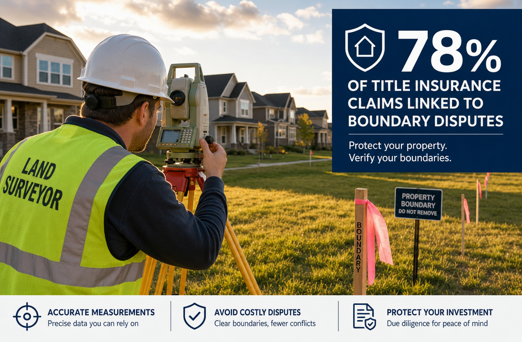
- Boundary clarity prevents value erosion: Up to 78% of title insurance claims stem from boundary issues that a current survey would have caught early [1].
- Surveys accelerate sales: Properties with recent surveys close approximately 11% faster due to reduced title complications [9].
- Development potential is unlocked, not guaranteed: Topographic and boundary surveys reveal what a site can and cannot support — critical intelligence before planning applications.
- Buyer confidence is a measurable asset: Transparent survey documentation reduces negotiation friction and supports asking-price justification.
- The 2026 ALTA standards raise the bar: New requirements for clearer easement disclosure and water boundary notes are reshaping commercial transaction expectations [2].
Why Boundary Clarity Is the Foundation of Property Value
Every property's market value rests on one assumption: that the seller actually owns what they are selling. When that assumption is uncertain, buyers discount their offers — or walk away entirely.
The Hidden Cost of Boundary Ambiguity
Boundary disputes are far more common than most sellers expect. A striking 78% of title insurance claims relate to boundary issues that a proper land survey would have identified [1]. These disputes can reduce property values by 15–25% in cases involving encroachment, and they frequently delay or collapse transactions entirely.
💬 "No credible evidence exists that surveys alone increase property values beyond preventing value erosion from boundary disputes." — PwC, Emerging Trends in Real Estate 2026 [10]
This PwC observation is important context. Land surveys are primarily risk mitigation tools rather than value-creation mechanisms in isolation. However, preventing a 15–25% value reduction is, in practical terms, a form of value enhancement — one that costs a fraction of what it protects.
What a Boundary Survey Actually Reveals
A boundary survey (typically costing £900–£4,200 in the UK, or $1,200–$5,500 in the US) [3] establishes:
- Exact legal boundaries of the parcel
- Encroachments from neighbouring structures, fences, or driveways
- Easements and rights of way that affect use or development
- Discrepancies between title deeds and physical reality
When sellers present this documentation upfront, they remove one of the most common reasons buyers reduce offers or request price reductions after surveys. For buyers considering a RICS Building Survey or Level 3 Building Survey, having boundary documentation already in place signals a well-managed property and accelerates due diligence.
The 2026 ALTA Standards: A New Benchmark for Transparency
The updated 2026 ALTA/NSPS Minimum Standard Detail Requirements (effective February 23, 2026) now mandate that surveyors provide more comprehensive notes on the face of the survey when discrepancies arise [2]. Critically, the new standards also require explicit notation when:
- Water boundaries may change naturally over time (particularly relevant for coastal and riverside properties)
- Easements are unclear or overlapping
- There are conflicts between recorded and observed boundary lines
This greater transparency benefits sellers in high-value markets. When buyers and their solicitors can see that discrepancies have been professionally identified and documented, transaction confidence rises — and so does the likelihood of reaching asking price.
| Survey Type | Typical Cost (US) | Primary Benefit |
|---|---|---|
| Boundary Survey | $1,200–$5,500 | Dispute prevention, title clarity |
| ALTA Survey | $2,500–$10,000 | Commercial transactions, lender compliance |
| Topographic Survey | $2,000–$6,500 | Development planning, constraint identification |
| Mortgage Survey | $1,500–$4,500 | Lender requirement, encroachment verification |
Sources: [3][4]
How Recent Land Surveys Skyrocket Property Values Through Development Potential
Development potential is one of the most powerful — and most frequently overlooked — value drivers in residential and commercial property. A site that appears to be a simple garden or paddock may hold planning permission potential worth multiples of its current use value. Equally, a site that appears developable may have constraints that make building prohibitively expensive. A recent survey is the tool that separates these scenarios with evidence.
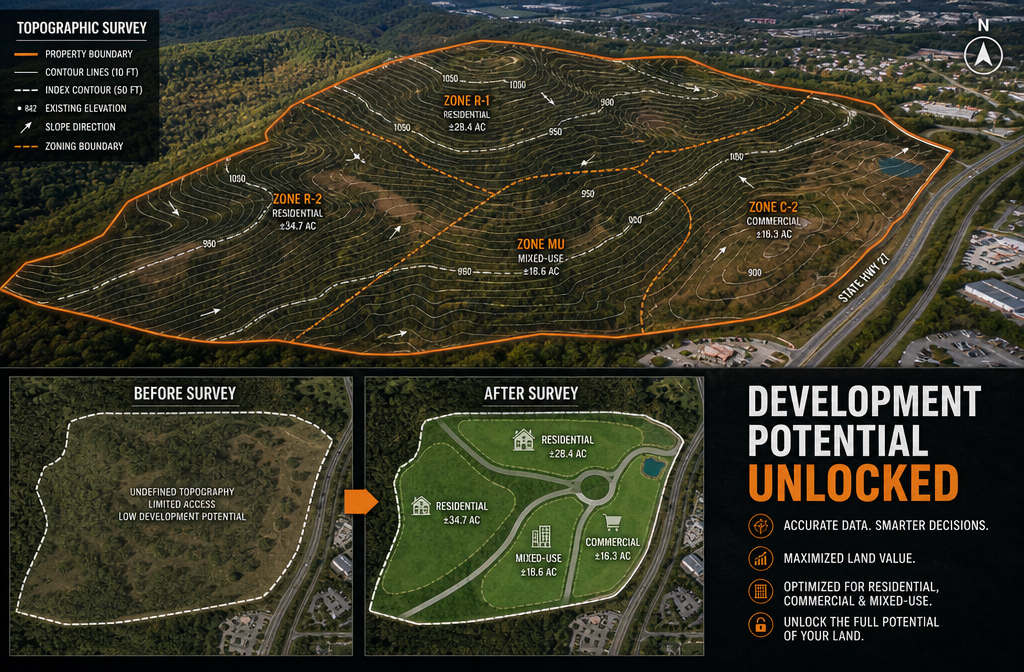
Topographic Surveys: Revealing What the Land Can Actually Support
Topographic surveys map the physical characteristics of a site: elevation changes, drainage patterns, vegetation, and existing structures. This data is essential for:
- Pre-planning applications — local authorities require accurate topographic data before granting permission
- Flood risk assessment — identifying low-lying areas before purchase or development
- Infrastructure planning — determining where utilities, drainage, and access routes can be positioned
Importantly, topographic surveys also reveal constraints. Research shows that 73% of surveyed properties reveal at least one limitation — wetlands, steep slopes, or flood zones — that restricts development potential [3]. Knowing this before purchase prevents costly planning failures.
For commercial sites, understanding these constraints is particularly valuable. Pairing topographic data with a commercial building survey gives investors a complete picture of both the land and the structures on it.
Zoning Insights and Permitted Development Rights
A current survey, combined with local planning data, can reveal whether a property qualifies for:
- Permitted development extensions without full planning permission
- Change of use from residential to commercial or mixed-use
- Plot subdivision to create additional saleable parcels
- Agricultural to residential conversion under relaxed planning rules
These possibilities are not created by the survey itself — but they cannot be confidently pursued without one. Buyers who can see this potential clearly documented are willing to pay a premium for the certainty that the opportunity is real.
Party Wall Considerations and Development Boundaries
Development projects in urban areas frequently encounter party wall issues. Understanding exactly where boundaries lie — and what obligations exist under the Party Wall etc. Act 1996 — is essential before any construction begins. Misunderstanding the 3-metre rule for party walls or proceeding without proper notices can result in injunctions, delays, and significant legal costs.
A recent boundary survey eliminates ambiguity about where one owner's rights end and another's begin — a practical prerequisite for any development project.
How Recent Land Surveys Skyrocket Property Values by Building Buyer Confidence

The psychology of property transactions is often underestimated. Buyers make emotional decisions and then seek rational justification. A well-documented, recent survey provides exactly that justification — and removes the anxiety that drives price chipping.
The Speed-to-Sale Advantage 🚀
Properties with recent surveys close approximately 11% faster than those without, primarily because title issues are identified and resolved before they become transaction-blocking problems [9]. In a market where mortgage offers expire, chains collapse, and buyers lose confidence during prolonged due diligence, speed is a genuine financial asset.
In 2026, 62% of residential real estate transactions require surveys due to lender requirements [4]. When a seller already has a current survey on file, lenders' requirements are often satisfied more quickly, reducing the risk of delays that erode buyer confidence.
Reducing Negotiation Friction
One of the most common ways sellers lose money is not through a low initial offer — it is through post-survey price reductions. When a buyer's surveyor identifies boundary ambiguities, potential encroachments, or undisclosed easements, they have legitimate grounds to renegotiate. Sellers who have already commissioned a thorough survey remove this leverage.
Understanding the difference between a mortgage valuation and a full survey is critical here. A mortgage valuation protects the lender; it does not protect the buyer or seller from boundary-related surprises. Only a proper land survey provides that protection.
What Buyers Actually Look For in 2026
Sophisticated buyers — and their solicitors — now routinely request:
- ✅ Evidence of recent boundary surveys
- ✅ Confirmation that structures are within legal boundaries
- ✅ Documentation of any easements, rights of way, or covenants
- ✅ Clarity on shared boundaries and party wall agreements
- ✅ Topographic data where development potential is part of the value proposition
Sellers who can provide this documentation upfront are positioned as transparent, low-risk vendors — a status that commands premium pricing in competitive markets.
The ROI of Commissioning a Survey Before Listing
Consider the numbers:
- Average survey cost: $2,300 (national US average in 2026) [4]
- Average value erosion from boundary disputes: 15–25% of property value [3]
- Speed advantage: 11% faster closing [9]
- Title insurance claims prevented: Addresses 78% of claim triggers [1]
On a £400,000 property, preventing even a 5% price reduction saves £20,000 — against a survey cost of perhaps £1,500–£2,500. The return on investment is clear.
For those unsure which type of survey best suits their needs, a comparison of different types of survey provides a practical starting point. Working with a RICS Chartered Building Surveyor ensures that survey findings are professionally documented and carry weight with lenders, insurers, and solicitors.
Maximising Survey ROI in Hot Markets: Practical Strategies
The land surveying market is growing rapidly — projected to expand from $5.5 billion in 2024 to $9.3 billion by 2033 at a 6.5% CAGR [5]. This growth reflects increasing regulatory requirements and transaction complexity, not just volume. In this environment, strategic survey commissioning separates informed sellers from reactive ones.
Timing Your Survey for Maximum Impact
- Commission before listing, not after accepting an offer. Pre-listing surveys allow time to resolve issues before they become negotiating chips.
- Update surveys older than five years. Boundary markers shift, neighbours build extensions, and drainage patterns change. Outdated surveys provide false confidence.
- Align with planning applications. If development potential is part of the value story, commission a topographic survey simultaneously with boundary work to present a complete picture to buyers.
Choosing the Right Survey for the Right Situation
| Situation | Recommended Survey Type |
|---|---|
| Standard residential sale | Boundary survey + title check |
| Property with development potential | Topographic + boundary survey |
| Commercial transaction | ALTA/NSPS survey (2026 standards) |
| Lender requirement | Mortgage survey |
| Dispute or litigation | Expert witness survey |
For properties with structural concerns, pairing land survey data with a structural survey provides the comprehensive documentation that premium buyers expect.
Working With Qualified Professionals
The 2026 ALTA standards update specifically requires greater professional accountability from surveyors [2]. Choosing a qualified, accredited surveyor is not optional — it is the difference between documentation that satisfies lenders and title insurers, and documentation that raises more questions than it answers.
Conclusion: Turn Survey Data Into Selling Power
The evidence is clear: how recent land surveys skyrocket property values: boundary clarity, development potential, and buyer confidence is not a theoretical proposition — it is a practical strategy with measurable financial outcomes.
Surveys do not magically add value to land. What they do is protect existing value, accelerate transactions, and give buyers the confidence to pay asking price rather than discount for uncertainty. In a 2026 market where 62% of transactions require surveys anyway [4], sellers who commission their own survey upfront simply control the narrative — and the outcome.
Actionable Next Steps ✅
- Assess your current survey status. If your last boundary survey is more than five years old, commission an update before listing.
- Match survey type to property type. Use the table above to identify the right survey for your situation.
- Engage a RICS-accredited surveyor. Ensure documentation meets lender and title insurer requirements.
- Use survey findings proactively. Share documentation with potential buyers early in the process to reduce negotiation friction.
- Consider development potential. If your site may have planning potential, commission a topographic survey alongside boundary work to maximise value presentation.
- Get a professional quote. Understanding survey costs and valuation options upfront allows accurate ROI calculation before committing.
The cost of a quality survey is measured in hundreds or low thousands. The value it protects — and the premium it helps achieve — is measured in tens of thousands. That is not a gamble. That is strategy.
References
[1] Land Survey What It Is Types And What It Costs In – https://www.amerisave.com/glossary/land-survey-what-it-is-types-and-what-it-costs-in
[2] 2026 Alta Survey Standards Updates – https://www.hklaw.com/en/insights/publications/2026/03/2026-alta-survey-standards-updates
[3] How Much Does Land Survey Cost – https://www.angi.com/articles/how-much-does-land-survey-cost.htm
[4] Land Survey Costs In 2026 Price Trends Technologys Impact And Budget Planning For Property Owners – https://wimbledonsurveyors.com/land-survey-costs-in-2026-price-trends-technologys-impact-and-budget-planning-for-property-owners/
[5] Land Surveying Market 2026 Deep Dive Trends Growth Aslve – https://www.linkedin.com/pulse/land-surveying-market-2026-deep-dive-trends-growth-aslve
[9] 2026 Housing Market Predictions – https://www.mckissock.com/blog/appraisal/2026-housing-market-predictions/
[10] Emerging Trends In Real Estate Pwc Uli – https://www.pwc.com/us/en/industries/financial-services/asset-wealth-management/real-estate/emerging-trends-in-real-estate-pwc-uli.html