The property surveying industry stands at a transformative crossroads in 2026. Coastal homeowners facing unprecedented climate threats, commercial property managers drowning in lease documentation, and urban planners grappling with infrastructure demands all share a common challenge: traditional surveying methods can no longer keep pace with modern complexity. Enter artificial intelligence and machine learning—technologies that are fundamentally reshaping how professionals assess properties, predict risks, and deliver actionable insights. What once required weeks of manual fieldwork and analysis now happens in hours, with accuracy rates exceeding 95% and labor costs slashed by up to 50%[2]. This isn't just incremental improvement; it's a complete reimagining of property assessment in an era where climate change, rapid urbanization, and data abundance demand smarter, faster solutions.
Revolutionizing Property Surveys: How AI and Machine Learning Are Predicting Risks and Automating Workflows in 2026 represents more than technological advancement—it signals a paradigm shift in how the built environment is understood, monitored, and protected. From autonomous drones that navigate complex terrains to predictive algorithms that forecast geological disasters months in advance, AI-enhanced surveying delivers capabilities that seemed like science fiction just five years ago[1].
Key Takeaways
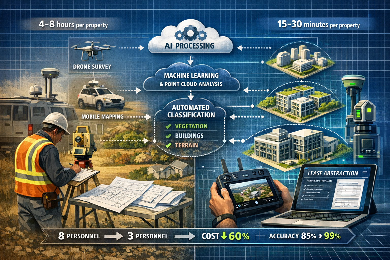
🔑 AI reduces survey processing time by 50-90%: Tasks that previously required 4-8 hours per property now complete in 15-30 minutes with 95-99% accuracy through automated lease abstraction and data classification[5]
🔑 Predictive risk analytics prevent disasters: Machine learning models analyze historical data combined with environmental factors to forecast floods, landslides, soil erosion, and structural deformations before they occur[2]
🔑 Autonomous technology transforms field operations: AI-powered drones and sensors enable real-time data capture, obstacle avoidance, and optimal flight path adjustment without constant human supervision[2]
🔑 Workforce optimization reduces operational costs: Survey projects that once required large field teams now operate with fewer personnel through intelligent automation while maintaining higher quality standards[2]
🔑 Surveyors evolve rather than disappear: AI enhances the profession by handling repetitive tasks, but human expertise remains essential for decision-making, legal compliance, and managing complex field conditions[1]
Understanding the AI Revolution in Property Surveying
The Traditional Survey Challenge
For decades, property surveying relied on labor-intensive processes. Chartered surveyors would spend days conducting RICS building surveys, manually measuring structures, documenting conditions, and analyzing data through spreadsheets and written reports. A comprehensive homebuyer survey could take a full week from initial site visit to final report delivery.
The limitations were significant:
- Time consumption: Data collection required multiple site visits spanning several days
- Human error: Manual measurements and visual assessments introduced inconsistencies
- Limited scope: Physical access constraints prevented comprehensive analysis of difficult-to-reach areas
- Delayed insights: Processing and analysis happened long after fieldwork concluded
- Resource intensity: Large teams needed for complex commercial properties
- Static assessments: Surveys captured single moments in time without ongoing monitoring
How AI Transforms the Survey Process
Artificial intelligence fundamentally reimagines each stage of the surveying workflow. Rather than replacing human expertise, AI acts as a force multiplier—automating repetitive tasks, processing massive datasets instantaneously, and revealing patterns invisible to the human eye.
Data Collection Acceleration ⚡
Traditional surveying required days or weeks of fieldwork. AI-enhanced sensors and machine learning now enable real-time data capture through multiple channels[2]:
- Autonomous drones equipped with LiDAR and photogrammetry sensors
- Mobile mapping vehicles with continuous scanning capabilities
- Fixed sensor networks providing 24/7 monitoring
- Satellite imagery integration for large-scale analysis
This multi-source approach creates comprehensive property profiles in hours rather than weeks.
Intelligent Processing and Classification 🧠
The true revolution happens in data processing. AI algorithms can:
- Distinguish between vegetation, buildings, and terrain features within LiDAR point clouds
- Automatically classify structural elements (walls, roofs, foundations)
- Identify anomalies and potential defects through pattern recognition
- Generate detailed 3D models without manual intervention
- Cross-reference multiple data sources for validation
According to industry analysis, AI dramatically reduces human error and processing time in these classification tasks[2].
Predictive Analytics and Risk Assessment 📊
Perhaps most transformative is AI's ability to predict future conditions. Machine learning models analyze:
- Historical survey data spanning decades
- Environmental factors (rainfall, temperature, soil composition)
- Geological patterns and seismic activity
- Infrastructure age and maintenance records
- Climate change projections
These models anticipate geological changes, soil erosion, landslides, ground subsidence, and infrastructure deformations before they become critical issues[2]. For properties requiring subsidence surveys, this predictive capability represents a game-changing advancement.
Revolutionizing Property Surveys Through Predictive Risk Analytics
Climate Change and Coastal Property Challenges
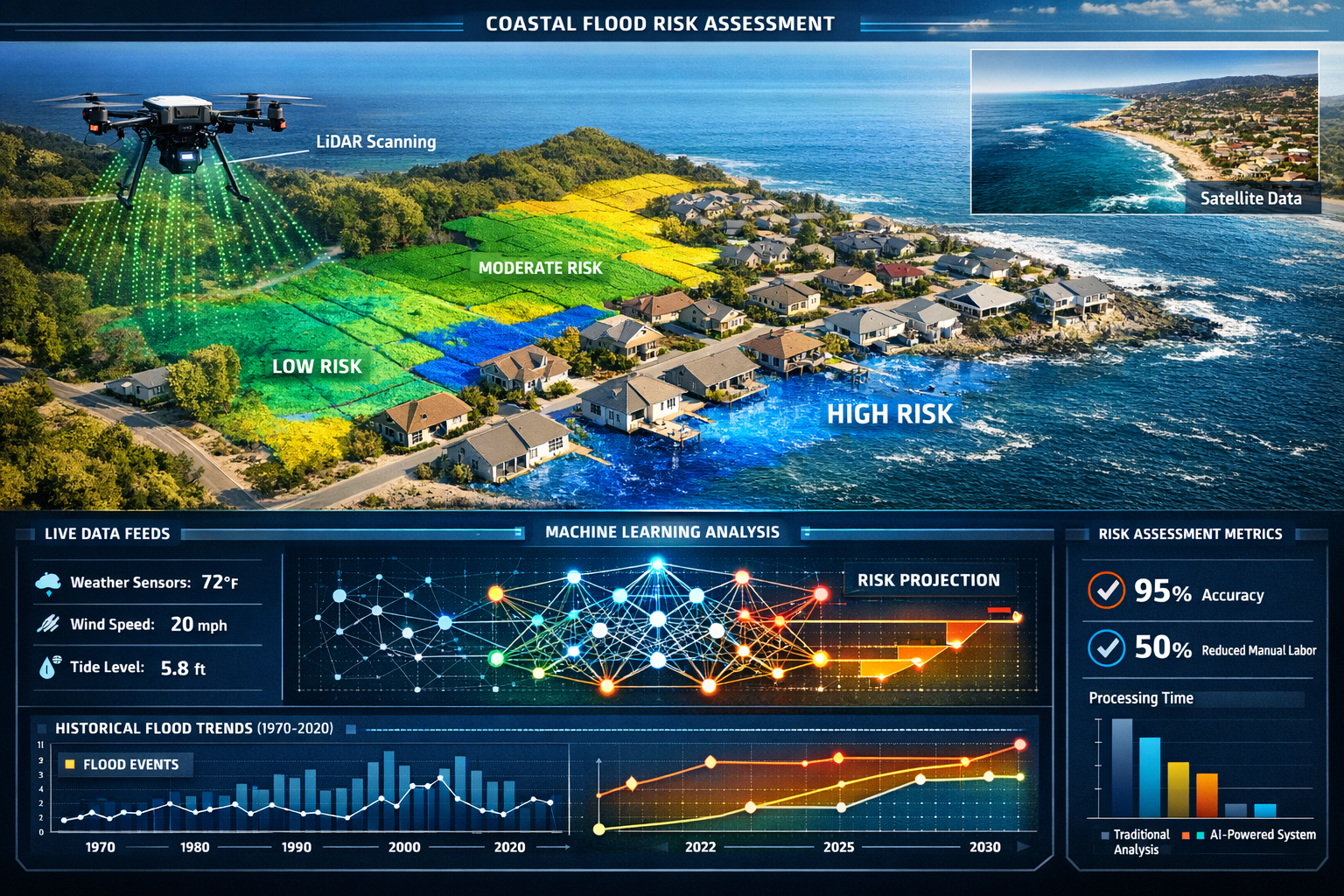
Coastal properties face escalating threats in 2026. Rising sea levels, intensifying storms, and changing precipitation patterns create unprecedented risk profiles. Traditional surveys provided snapshots—AI delivers continuous risk monitoring and forward-looking predictions.
Flood Prediction Systems 🌊
AI-powered early warning systems represent one of the most promising applications. By analyzing historical flood data, current weather patterns, topographical information, and climate models, machine learning algorithms can predict devastating flooding events with increasing accuracy[1].
These systems consider:
- Hydrological patterns: Watershed behavior, drainage capacity, groundwater levels
- Infrastructure vulnerability: Storm drain capacity, flood defense effectiveness
- Temporal factors: Seasonal variations, tidal cycles, extreme weather probability
- Climate projections: Sea level rise scenarios, precipitation trend analysis
"AI can predict devastating events such as flooding and landslides using historical data, though these tools remain in early development stages." – Industry Analysis[1]
While still evolving, these predictive capabilities already inform property valuations, insurance underwriting, and development decisions. Properties requiring RICS valuation services increasingly incorporate AI-generated risk assessments into their reports.
Landslide and Geological Risk Prediction
Beyond flooding, AI excels at identifying geological instability. Machine learning models process:
- Soil composition data: Permeability, cohesion, moisture content
- Slope analysis: Gradient calculations, vegetation cover, erosion patterns
- Seismic history: Earthquake frequency, magnitude trends
- Weather correlation: Rainfall intensity thresholds that trigger instability
These algorithms identify high-risk areas months before visible signs emerge. For properties in vulnerable regions, this early warning enables preventive interventions that save lives and reduce financial losses.
Structural Deformation Monitoring
AI-powered monitoring systems track millimeter-scale changes in building structures over time. By combining:
- Regular drone surveys capturing high-resolution imagery
- LiDAR scans measuring precise dimensional changes
- Thermal imaging detecting moisture intrusion
- Vibration sensors monitoring structural stress
Machine learning algorithms detect patterns indicating foundation settlement, structural fatigue, or material degradation. This continuous monitoring approach far surpasses periodic RICS home surveys in detecting emerging problems.
Case Study: Coastal Property Risk Assessment
Consider a typical scenario facing property owners in 2026:
A coastal residential development built in the 1990s faces increasing flood risk. Traditional surveys conducted every 5-10 years provided limited insight into changing conditions.
AI-Enhanced Approach:
- Autonomous drone surveys capture complete property data quarterly
- LiDAR scanning creates detailed 3D terrain models showing elevation changes
- Machine learning algorithms analyze 30 years of flood data, current sea level trends, and climate projections
- Predictive models generate risk scenarios for 5, 10, and 20-year timeframes
- Automated reporting delivers actionable insights to property managers monthly
Results:
- Early identification of vulnerable drainage systems requiring upgrade
- Predictive timeline showing when flood defenses will become inadequate
- Cost-benefit analysis for various mitigation strategies
- Insurance optimization through documented risk reduction efforts
- 50% reduction in survey costs through automation[2]
This integrated approach transforms reactive property management into proactive risk mitigation.
Quantifying the Impact
The efficiency gains are substantial:
| Survey Aspect | Traditional Method | AI-Enhanced Method | Improvement |
|---|---|---|---|
| Data Collection Time | 3-7 days | 2-4 hours | 90% reduction |
| Processing Time | 5-10 days | 1-2 hours | 95% reduction |
| Accuracy Rate | 85-90% | 95-99% | 10% improvement |
| Team Size Required | 5-8 personnel | 2-3 personnel | 60% reduction |
| Cost per Survey | Baseline | 40-50% of baseline | 50% savings |
These metrics demonstrate why AI adoption is accelerating across the surveying profession[2].
Automating Workflows: From Data Capture to Deliverables
Autonomous Drone Technology
Intelligent Flight Planning 🚁
Modern surveying drones operate with remarkable autonomy. AI models embedded in flight systems:
- Identify areas of interest automatically based on project parameters
- Avoid obstacles in real-time using computer vision and sensor fusion
- Adjust flight paths for optimal data collection based on lighting, weather, and terrain
- Optimize battery usage by calculating efficient survey patterns
- Coordinate multiple drones for large-scale projects
This autonomy dramatically reduces the expertise required for drone operation while improving data quality. What once required specialized pilots now operates with minimal supervision[2].
Real-Time Data Processing
Advanced drones process data during flight, providing immediate feedback:
- Identifying incomplete coverage requiring additional passes
- Flagging anomalies for human review
- Generating preliminary 3D models before landing
- Transmitting priority findings to ground teams instantly
This real-time capability enables adaptive surveying strategies that respond to emerging findings.
Automated Lease Abstraction and Document Analysis
For commercial property professionals, lease analysis represents a massive time sink. A typical commercial lease contains 50-100 pages of complex legal language requiring careful review.
Traditional Process:
- 4-8 hours per lease document
- Manual extraction of key terms, dates, obligations
- High error rates due to inconsistent formatting
- Difficulty tracking changes across lease amendments
AI-Powered Solution:
Machine learning models trained on thousands of lease documents now automate this process, reducing review time to 15-30 minutes per document while achieving 95-99% accuracy rates[5].
These systems:
- Extract critical dates (expiration, renewal options, rent escalations)
- Identify financial obligations and payment schedules
- Flag unusual clauses requiring human review
- Compare lease terms against standard benchmarks
- Generate standardized summaries for portfolio analysis
For property managers handling hundreds of leases, this automation represents thousands of hours saved annually. When combined with expert witness reports for dispute resolution, AI-generated lease analysis provides defensible documentation.
LiDAR Point Cloud Classification
LiDAR scanners generate millions of data points representing three-dimensional space. Manually classifying these points—distinguishing ground from vegetation, buildings from trees, roads from sidewalks—consumed enormous resources.
AI Classification Capabilities:
Advanced algorithms now automatically classify point cloud data with exceptional accuracy[2]:
- Ground points: Creating digital terrain models
- Vegetation: Distinguishing trees, shrubs, grass by height and density
- Buildings: Identifying structures, roofs, walls, architectural features
- Infrastructure: Roads, bridges, utilities, signage
- Water features: Rivers, ponds, drainage systems
This automated classification enables:
- Rapid generation of topographic maps
- Precise volume calculations for earthwork projects
- Detailed 3D building models for BIM integration
- Floodplain mapping with exceptional accuracy
- Forestry analysis and environmental monitoring
The processing time reduction is staggering—what required weeks of manual work now completes in hours.
3D Modeling and BIM Integration
AI-enhanced LiDAR generates highly detailed 3D models with minimal human intervention[2]. These models serve multiple purposes:
Urban Planning Applications:
- Creating accurate digital twins of entire cities
- Integrating with Building Information Modeling (BIM) systems
- Supporting smart infrastructure development
- Enabling sustainable growth planning
Property Assessment:
- Precise volume calculations for roof surveys
- Detailed condition documentation
- Historical comparison revealing structural changes
- Virtual site visits reducing travel requirements
Engineering Analysis:
- Structural load calculations
- Beam calculations for renovation projects
- Foundation design optimization
- Accessibility compliance verification
The integration with BIM systems creates living documents that evolve with the property, supporting lifecycle management from construction through demolition.
Predictive Equipment Maintenance
Survey equipment represents significant capital investment. Drones, GNSS systems, and LiDAR scanners require careful maintenance to ensure accuracy and reliability.
AI-Powered Monitoring:
Sensors embedded in surveying equipment track performance metrics continuously[2]:
- Battery degradation patterns
- Sensor calibration drift
- Motor wear indicators
- Component temperature anomalies
- Vibration signatures indicating mechanical issues
Machine learning models analyze these metrics to predict equipment failures before they occur, enabling:
- Scheduled maintenance during non-critical periods
- Parts replacement before failures impact projects
- Extended equipment lifespan through optimal care
- Minimized downtime reducing project delays
- Cost optimization avoiding emergency repairs
This predictive approach transforms equipment management from reactive to proactive, ensuring survey teams maintain operational readiness.
The Evolving Role of Professional Surveyors
AI as Enhancement, Not Replacement
A persistent concern surrounding AI adoption centers on job displacement. The reality for surveying professionals is more nuanced and ultimately optimistic.
What AI Handles Well:
- ✅ Repetitive data processing tasks
- ✅ Pattern recognition across massive datasets
- ✅ Mathematical calculations and measurements
- ✅ Consistent application of classification rules
- ✅ 24/7 monitoring without fatigue
- ✅ Simultaneous analysis of multiple data sources
What Requires Human Expertise:
- 👤 Professional judgment in ambiguous situations
- 👤 Legal compliance and regulatory navigation
- 👤 Client communication and expectation management
- 👤 Ethical considerations in reporting
- 👤 Complex field conditions requiring adaptive strategies
- 👤 Quality assurance and validation of AI outputs
- 👤 Strategic planning and project design
Industry experts consistently emphasize that AI will not replace surveyors but will significantly enhance the profession[1]. The technology automates data processing, improves accuracy, and reduces repetitive tasks—freeing professionals to focus on higher-value activities requiring human judgment.
New Skill Requirements
The AI revolution demands evolving competencies from surveying professionals:
Technical Skills:
- Understanding machine learning fundamentals
- Data interpretation and validation
- Software platform management
- Drone operation and autonomous system oversight
- Cloud platform utilization
- BIM integration capabilities
Analytical Skills:
- Critical evaluation of AI-generated insights
- Risk assessment incorporating predictive analytics
- Statistical interpretation
- Scenario modeling and projection analysis
Communication Skills:
- Explaining AI methodologies to clients
- Translating technical findings into actionable recommendations
- Managing stakeholder expectations regarding automation
- Presenting complex data visualizations effectively
Professional development programs increasingly incorporate these competencies, ensuring chartered surveyors remain at the forefront of technological advancement.
Quality Assurance and Professional Standards
AI outputs require validation by qualified professionals. Regulatory bodies and professional organizations maintain standards ensuring:
- Accuracy verification: Human review of AI-generated measurements and classifications
- Methodology transparency: Clear documentation of algorithms and data sources
- Bias detection: Identifying and correcting systematic errors in AI models
- Compliance confirmation: Ensuring outputs meet legal and professional standards
- Liability clarity: Establishing responsibility chains for AI-assisted work
When conducting RICS Homebuyer Surveys Level 2, professionals must validate AI findings against established protocols, maintaining the integrity that clients expect.
Career Opportunities in AI-Enhanced Surveying
Rather than eliminating positions, AI creates new specializations:
AI Survey Specialist:
- Designing and implementing AI workflows
- Training machine learning models on survey data
- Optimizing autonomous drone operations
- Developing custom algorithms for specific applications
Data Analyst:
- Interpreting complex datasets from multiple sources
- Creating predictive models for risk assessment
- Generating insights from historical survey archives
- Supporting decision-making with statistical analysis
Technology Integration Manager:
- Coordinating AI tools with traditional methods
- Managing cloud platforms and data infrastructure
- Ensuring interoperability between systems
- Leading digital transformation initiatives
Risk Assessment Consultant:
- Leveraging AI predictions for strategic planning
- Advising clients on climate adaptation strategies
- Developing mitigation recommendations
- Conducting scenario analysis for long-term planning
These emerging roles offer career advancement opportunities for professionals embracing technological change.
Implementation Strategies for Surveying Firms
Phased Adoption Approach
Successful AI integration requires strategic planning rather than wholesale transformation. Leading firms follow phased implementation:
Phase 1: Foundation Building (Months 1-3)
- Assess current workflows identifying automation opportunities
- Invest in cloud infrastructure and data management systems
- Train staff on AI fundamentals and new technologies
- Pilot test AI tools on non-critical projects
Phase 2: Core Integration (Months 4-9)
- Implement automated data classification for LiDAR processing
- Deploy autonomous drone systems for routine surveys
- Integrate AI-powered document analysis for lease abstraction
- Establish quality assurance protocols for AI outputs
Phase 3: Advanced Capabilities (Months 10-18)
- Develop predictive risk models using historical data
- Create continuous monitoring systems for key properties
- Build custom machine learning models for specialized applications
- Achieve full BIM integration with 3D modeling workflows
Phase 4: Optimization (Months 19+)
- Refine algorithms based on performance data
- Expand autonomous operations to complex projects
- Develop proprietary AI capabilities as competitive differentiators
- Contribute to industry standards and best practices
This measured approach minimizes disruption while building organizational capabilities systematically.
Technology Stack Considerations
Modern surveying firms require integrated technology ecosystems:
Data Capture Layer:
- Autonomous drones with LiDAR and photogrammetry sensors
- Mobile mapping vehicles for corridor surveys
- Fixed monitoring sensors for continuous observation
- Satellite imagery integration platforms
Processing Layer:
- Cloud computing infrastructure for massive dataset processing
- Machine learning platforms (TensorFlow, PyTorch, custom solutions)
- Point cloud classification software
- Automated 3D modeling tools
Analysis Layer:
- Predictive analytics platforms
- Risk assessment modeling tools
- BIM integration software
- Visualization and reporting systems
Delivery Layer:
- Client portals for real-time access
- Mobile applications for field verification
- Automated report generation
- API connections to client systems
Selecting compatible, scalable solutions ensures long-term viability and prevents technology lock-in.
Cost-Benefit Analysis
AI adoption requires upfront investment but delivers substantial returns:
Initial Costs:
- Hardware: Autonomous drones, sensors, computing infrastructure ($50,000-$200,000)
- Software: Licenses, cloud services, specialized applications ($20,000-$80,000 annually)
- Training: Staff development, consulting services ($10,000-$30,000)
- Process redesign: Workflow optimization, quality assurance development ($15,000-$40,000)
Ongoing Savings:
- Labor reduction: 40-60% fewer hours per project[2]
- Faster turnaround: 2-3x project capacity with same staff
- Error reduction: Fewer costly mistakes and rework
- Equipment optimization: Predictive maintenance reducing replacement costs
- Competitive advantage: Premium pricing for advanced capabilities
Most firms achieve positive ROI within 12-18 months of implementation, with benefits accelerating as staff proficiency increases.
Client Communication and Value Proposition
Effectively communicating AI benefits to clients requires clarity and specificity:
For Residential Clients:
- "Our AI-enhanced surveys detect potential issues traditional methods miss"
- "Predictive analysis shows how your property might be affected by climate change"
- "Faster turnaround without compromising thoroughness"
- "3D models let you visualize findings clearly"
For Commercial Clients:
- "Automated lease analysis saves thousands of hours annually"
- "Continuous monitoring protects your property investment"
- "Predictive maintenance reduces unexpected repair costs"
- "Data-driven insights support strategic planning"
For Developers:
- "Site analysis completed in days rather than weeks"
- "Risk assessment informs optimal development strategies"
- "BIM integration streamlines entire project lifecycle"
- "Regulatory compliance documentation automated"
Demonstrating tangible value builds client confidence in AI-enhanced services, supporting premium pricing that reflects superior capabilities.
Future Directions: 2026 and Beyond
Fully Integrated Digital Workflows
The surveying industry is moving toward fully integrated digital workflows using AI, cloud platforms, autonomous drones, and real-time 3D modeling to deliver instant, highly accurate survey data[1].
This integration creates seamless information flow:
- Autonomous data capture occurs continuously or on-demand
- Cloud processing analyzes data in real-time
- AI classification organizes information automatically
- Predictive models generate risk assessments
- Automated reporting delivers insights to stakeholders
- BIM integration updates digital twins continuously
- Client portals provide 24/7 access to current information
This end-to-end automation represents the ultimate evolution of surveying—transforming from periodic snapshots to continuous intelligence.
Emerging Technologies on the Horizon
Several technologies will further enhance AI-powered surveying:
Quantum Computing:
- Processing complex simulations exponentially faster
- Enabling real-time analysis of entire cities
- Supporting climate modeling at unprecedented scales
Advanced Sensor Fusion:
- Combining LiDAR, radar, thermal, and hyperspectral imaging
- Creating comprehensive property profiles
- Detecting hidden defects invisible to current methods
Edge AI:
- Processing data directly on drones and sensors
- Eliminating cloud latency for time-critical applications
- Enabling offline operation in remote locations
Augmented Reality Integration:
- Overlaying AI insights onto physical environments
- Supporting real-time field decision-making
- Enhancing client presentations and stakeholder communication
Blockchain Verification:
- Creating immutable records of survey data
- Supporting legal defensibility
- Enabling trusted data sharing across organizations
Regulatory Evolution
As AI becomes ubiquitous in surveying, regulatory frameworks are adapting:
Emerging Standards:
- Accuracy requirements for AI-generated surveys
- Transparency mandates for algorithmic decision-making
- Professional liability frameworks for AI-assisted work
- Data privacy protections for property information
- Certification requirements for AI survey systems
Professional organizations collaborate with regulators ensuring standards protect public interests while enabling innovation. Firms conducting dilapidation surveys or other specialized assessments must stay current with evolving requirements.
Climate Adaptation and Resilience Planning
AI-powered surveying plays a crucial role in climate adaptation strategies:
Long-Term Risk Modeling:
- 50-100 year projections for sea level rise impacts
- Infrastructure vulnerability assessments
- Ecosystem change predictions
- Migration pattern analysis for climate refugees
Adaptation Planning:
- Optimal flood defense placement
- Building code recommendations for resilient construction
- Land use planning incorporating future conditions
- Insurance risk modeling for sustainable coverage
Continuous Monitoring:
- Real-time tracking of environmental changes
- Early warning systems for extreme events
- Infrastructure performance under stress conditions
- Ecosystem health indicators
These capabilities transform surveying from documenting current conditions to shaping resilient futures.
Democratization of Advanced Surveying
As AI tools mature and costs decrease, advanced surveying capabilities become accessible to smaller firms and individual practitioners:
Cloud-Based Platforms:
- Subscription models eliminating large capital investments
- Pre-trained AI models requiring minimal customization
- Automated workflows reducing technical expertise requirements
- Scalable processing matching project demands
Simplified Interfaces:
- User-friendly applications abstracting technical complexity
- Mobile-first design supporting field operations
- Automated quality checks ensuring professional standards
- Template-based reporting accelerating deliverables
This democratization expands access to cutting-edge capabilities, benefiting clients across market segments and property types. Whether conducting damp surveys or comprehensive commercial assessments, professionals of all firm sizes can leverage AI advantages.
Practical Applications Across Property Types
Residential Properties
Single-Family Homes:
- Automated roof condition assessment detecting early deterioration
- Foundation monitoring identifying settlement patterns
- Energy efficiency analysis through thermal imaging
- Predictive maintenance schedules optimizing repair timing
- Property value projections incorporating neighborhood trends
Multi-Family Developments:
- Portfolio-wide condition monitoring across hundreds of units
- Automated compliance tracking for safety regulations
- Tenant turnover optimization through predictive analytics
- Capital expenditure planning based on deterioration forecasting
- Common area maintenance scheduling
Commercial Properties
Office Buildings:
- Space utilization analysis optimizing tenant configurations
- HVAC performance monitoring reducing energy costs
- Structural health monitoring ensuring safety
- Lease portfolio management with automated abstraction
- Market positioning analysis through competitive benchmarking
Retail Centers:
- Foot traffic pattern analysis informing layout optimization
- Parking utilization monitoring
- Facade condition assessment for brand consistency
- Environmental compliance tracking
- Tenant mix optimization through predictive modeling
Industrial Facilities:
- Equipment placement optimization for workflow efficiency
- Loading dock capacity analysis
- Structural load monitoring for heavy machinery
- Expansion feasibility studies
- Environmental impact assessment
Infrastructure Projects
Transportation:
- Highway corridor surveys completed in days
- Bridge inspection with millimeter-precision deformation tracking
- Railway alignment verification
- Airport runway condition monitoring
- Tunnel structural integrity assessment
Utilities:
- Pipeline route optimization
- Transmission tower placement and monitoring
- Water infrastructure leak detection
- Solar farm site assessment
- Wind farm feasibility analysis
Public Works:
- Park and recreation facility planning
- Flood control infrastructure design
- Emergency response route optimization
- Public building condition assessment
- Historical preservation documentation
Specialized Applications
Heritage Properties:
- Non-invasive condition documentation
- Deterioration tracking over time
- Restoration planning with precise measurements
- Virtual preservation creating digital archives
- Public access through virtual tours
Agricultural Land:
- Topographical analysis for irrigation design
- Soil composition mapping
- Crop health monitoring
- Drainage optimization
- Property boundary verification
Environmental Sites:
- Contamination extent mapping
- Remediation progress monitoring
- Wetland delineation
- Wildlife habitat assessment
- Conservation easement verification
Each application demonstrates how Revolutionizing Property Surveys: How AI and Machine Learning Are Predicting Risks and Automating Workflows in 2026 delivers value across diverse property types and use cases.
Overcoming Implementation Challenges
Data Quality and Standardization
Challenge: AI models require high-quality, standardized data for optimal performance. Legacy survey data often lacks consistency.
Solutions:
- Implement data governance frameworks establishing quality standards
- Retroactively process historical surveys to standardize formats
- Establish validation protocols ensuring new data meets requirements
- Use data augmentation techniques expanding training datasets
- Collaborate with industry peers developing common standards
Staff Resistance and Change Management
Challenge: Experienced surveyors may resist adopting unfamiliar technologies, fearing obsolescence or questioning AI reliability.
Solutions:
- Emphasize AI as enhancement rather than replacement
- Provide comprehensive training with hands-on practice
- Demonstrate quick wins showing tangible benefits
- Involve staff in implementation planning and tool selection
- Celebrate successes and share positive outcomes
- Address concerns transparently with realistic expectations
Integration with Existing Systems
Challenge: Legacy software and workflows may not interface easily with new AI platforms.
Solutions:
- Prioritize tools offering robust API connections
- Implement middleware solutions bridging systems
- Plan phased migrations rather than wholesale replacements
- Maintain parallel systems during transition periods
- Work with vendors ensuring compatibility
- Document integration processes for troubleshooting
Cybersecurity and Data Privacy
Challenge: Cloud-based AI platforms and connected sensors create new security vulnerabilities.
Solutions:
- Implement multi-layer security protocols (encryption, authentication, access controls)
- Conduct regular security audits and penetration testing
- Train staff on cybersecurity best practices
- Establish data backup and disaster recovery procedures
- Comply with data privacy regulations (GDPR, CCPA, etc.)
- Use secure communication channels for sensitive information
- Vet vendors thoroughly for security capabilities
Accuracy Validation and Liability
Challenge: Determining responsibility when AI-generated findings prove inaccurate.
Solutions:
- Establish clear quality assurance protocols with human validation
- Document AI methodologies and limitations transparently
- Maintain professional liability insurance covering AI-assisted work
- Create audit trails showing validation steps
- Set appropriate confidence thresholds for automated decisions
- Require human review for high-stakes findings
- Develop contingency plans for AI system failures
Addressing these challenges proactively ensures successful implementation while maintaining professional standards and client trust. When conducting structural engineering assessments or other critical evaluations, validation protocols become especially important.
Measuring Success and ROI

Key Performance Indicators
Tracking specific metrics demonstrates AI implementation value:
Efficiency Metrics:
- Average survey completion time (target: 50-70% reduction)
- Data processing duration (target: 90% reduction)
- Report generation time (target: 80% reduction)
- Projects completed per surveyor annually (target: 2-3x increase)
Quality Metrics:
- Error rate in measurements (target: <1%)
- Client revision requests (target: 50% reduction)
- Accuracy of predictive models (target: >90%)
- Compliance violations (target: zero)
Financial Metrics:
- Revenue per surveyor (target: 40-60% increase)
- Operating margin improvement (target: 10-15 percentage points)
- Client acquisition cost (target: 30% reduction through referrals)
- Client retention rate (target: >95%)
Client Satisfaction Metrics:
- Net Promoter Score (target: >70)
- Average project rating (target: >4.5/5)
- Repeat business percentage (target: >60%)
- Referral rate (target: >40%)
Regular monitoring of these KPIs enables continuous improvement and demonstrates value to stakeholders.
Competitive Positioning
AI capabilities create significant competitive advantages:
Differentiation Factors:
- Faster turnaround times winning time-sensitive projects
- Superior accuracy reducing client risk
- Predictive insights unavailable from competitors
- Advanced visualization improving client understanding
- Scalability handling larger projects efficiently
- Innovation leadership attracting forward-thinking clients
Firms effectively leveraging AI can command premium pricing of 15-30% while maintaining higher margins through efficiency gains—a powerful combination for sustainable growth.
Conclusion: Embracing the AI-Powered Future of Property Surveying
Revolutionizing Property Surveys: How AI and Machine Learning Are Predicting Risks and Automating Workflows in 2026 represents far more than technological novelty—it signals a fundamental transformation in how the built environment is understood, protected, and optimized. The evidence is compelling: 50% reductions in manual labor, 95-99% accuracy rates, predictive capabilities that prevent disasters before they occur, and workflow automation that frees professionals to focus on high-value judgment and client service[2][5].
The coastal property owner facing climate threats, the commercial portfolio manager drowning in lease documentation, the urban planner designing resilient infrastructure—all benefit from AI-enhanced surveying delivering insights impossible through traditional methods. Autonomous drones navigate complex terrains capturing comprehensive data in hours. Machine learning algorithms process decades of historical information identifying patterns invisible to human analysis. Predictive models forecast risks months or years in advance, enabling proactive interventions that save lives and protect investments.
Yet technology alone doesn't create value—professional expertise remains essential. AI handles repetitive tasks, processes massive datasets, and maintains tireless vigilance, but human surveyors provide judgment, context, ethical consideration, and client relationships that no algorithm can replicate[1]. The most successful firms recognize this complementary relationship, investing in both cutting-edge technology and professional development that prepares staff for evolving roles.
Actionable Next Steps
For surveying professionals and property stakeholders ready to embrace this revolution:
For Surveying Firms:
- Assess current capabilities identifying automation opportunities and efficiency gaps
- Develop implementation roadmap with phased adoption timeline and resource requirements
- Invest in training ensuring staff develop AI literacy and technical competencies
- Pilot test technologies on non-critical projects before full-scale deployment
- Establish quality assurance protocols validating AI outputs against professional standards
- Communicate value proposition to clients emphasizing tangible benefits
- Monitor performance metrics tracking ROI and identifying optimization opportunities
For Property Owners and Managers:
- Request AI-enhanced surveys when engaging surveying professionals
- Ask about predictive capabilities particularly for climate-vulnerable properties
- Leverage continuous monitoring for high-value or critical assets
- Integrate AI insights into strategic planning and risk management
- Demand transparency regarding AI methodologies and validation processes
- Compare traditional vs. AI-enhanced options evaluating cost-benefit tradeoffs
- Stay informed about emerging capabilities and industry developments
For Industry Stakeholders:
- Participate in standards development ensuring regulations support innovation while protecting public interests
- Invest in research advancing AI capabilities for surveying applications
- Foster collaboration between technology providers, surveying professionals, and regulators
- Support education initiatives preparing the next generation of AI-literate surveyors
- Address ethical considerations proactively including bias, privacy, and accountability
- Share best practices accelerating industry-wide adoption and capability development
The future of property surveying is not approaching—it has arrived. Firms and professionals who embrace AI-powered capabilities position themselves at the forefront of an industry transformation that will define the next decade. Those who hesitate risk obsolescence in a market increasingly demanding the speed, accuracy, and predictive insights that only AI-enhanced surveying delivers.
Whether conducting RICS building surveys, comparing different types of survey options, or developing specialized assessment capabilities, the integration of artificial intelligence and machine learning represents the most significant advancement in surveying since the introduction of GPS technology.
The revolution is here. The question is not whether to participate, but how quickly to adapt and how effectively to leverage these transformative capabilities for competitive advantage and superior client service. The properties, communities, and infrastructure of tomorrow depend on the surveying decisions made today—decisions increasingly informed, enhanced, and optimized by the power of artificial intelligence.
References
[1] The Future Of Land Surveying Technology And Upcoming Trends In 2026 – https://metricop.com/blogs/land-surveying/the-future-of-land-surveying-technology-and-upcoming-trends-in-2026
[2] Ai Impact Analysis On Land Survey Equipment Industry – https://www.marketsandmarkets.com/ResearchInsight/ai-impact-analysis-on-land-survey-equipment-industry.asp
[3] Ailta – https://www.herox.com/AiLTA
[4] How Ai Is Changing Real Estate In The Usa – https://www.rentana.io/blog/how-ai-is-changing-real-estate-in-the-usa
[5] Best Ai Tools For Real Estate – https://www.v7labs.com/blog/best-ai-tools-for-real-estate
[6] Doubling Down On Digital – https://amerisurv.com/2026/02/01/doubling-down-on-digital/
[7] How Ai Is Changing The Role Of The Surveyor In Aec – https://www.gim-international.com/content/article/how-ai-is-changing-the-role-of-the-surveyor-in-aec
[8] Tech Shifts Property Managers Cant Ignore – https://www.buildium.com/blog/tech-shifts-property-managers-cant-ignore/
[9] Watch – https://www.youtube.com/watch?v=CSTodaZb4Vc