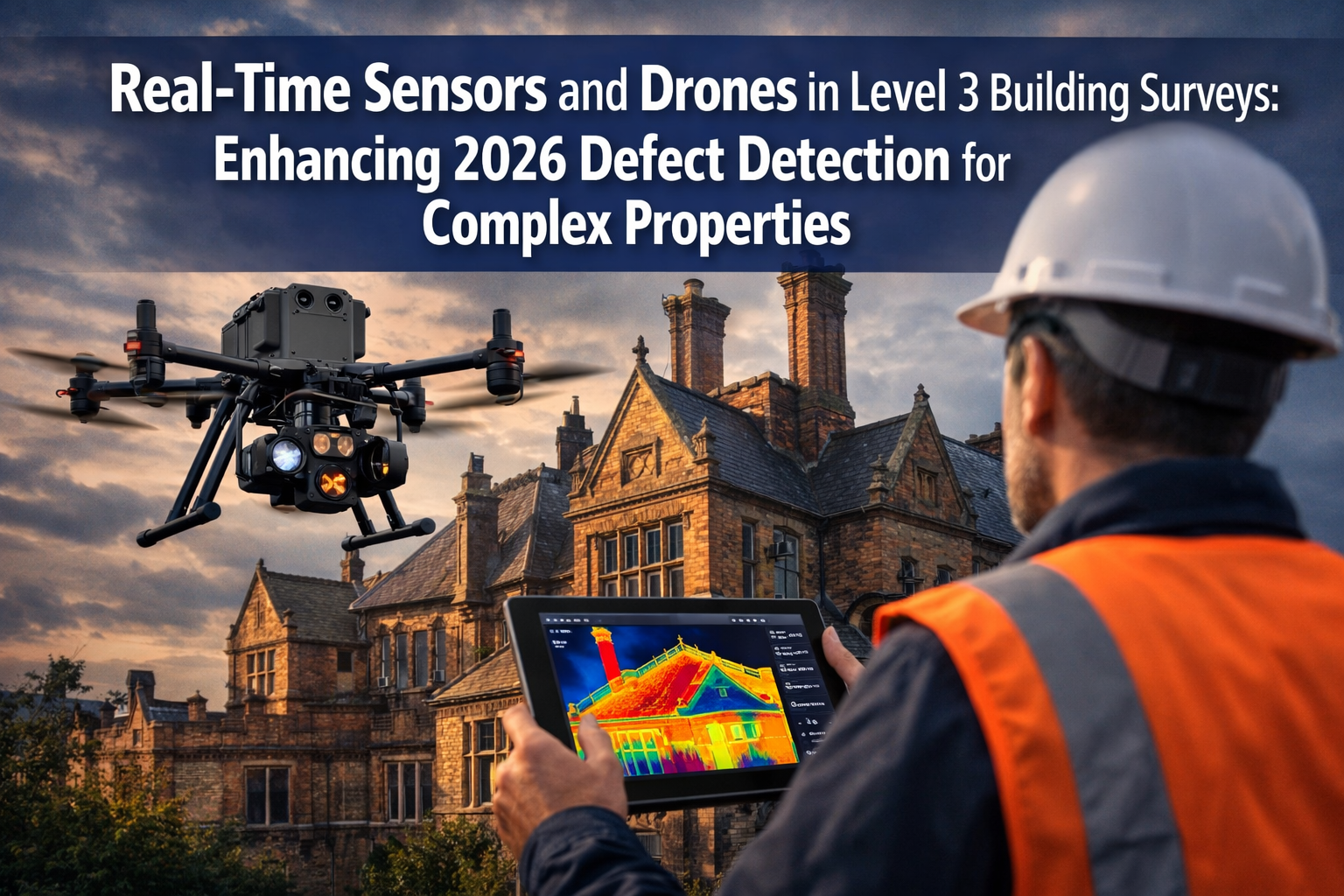
The commercial drone market reached $14.1 billion in 2024, with surveying and inspection applications driving 32% of industry growth [3]. This technological shift has transformed how surveyors approach complex property assessments, particularly when conducting comprehensive RICS Building Surveys Level 3 on heritage buildings, multi-unit developments, and structurally intricate properties. Real-Time Sensors and Drones in Level 3 Building Surveys: Enhancing 2026 Defect Detection for Complex Properties represents a fundamental change in how building professionals identify structural issues, moisture penetration, and thermal inefficiencies—reducing valuation delays by up to 40% while improving diagnostic accuracy.
Traditional Level 3 surveys required extensive scaffolding, cherry pickers, and multiple site visits to access difficult areas like chimneys, parapets, and complex rooflines. These logistical challenges often delayed property transactions by weeks and increased survey costs significantly. Modern drone technology equipped with thermal sensors, LiDAR scanners, and high-resolution cameras now provides immediate access to previously inaccessible areas, delivering real-time defect data that chartered surveyors can analyze instantly.
Key Takeaways
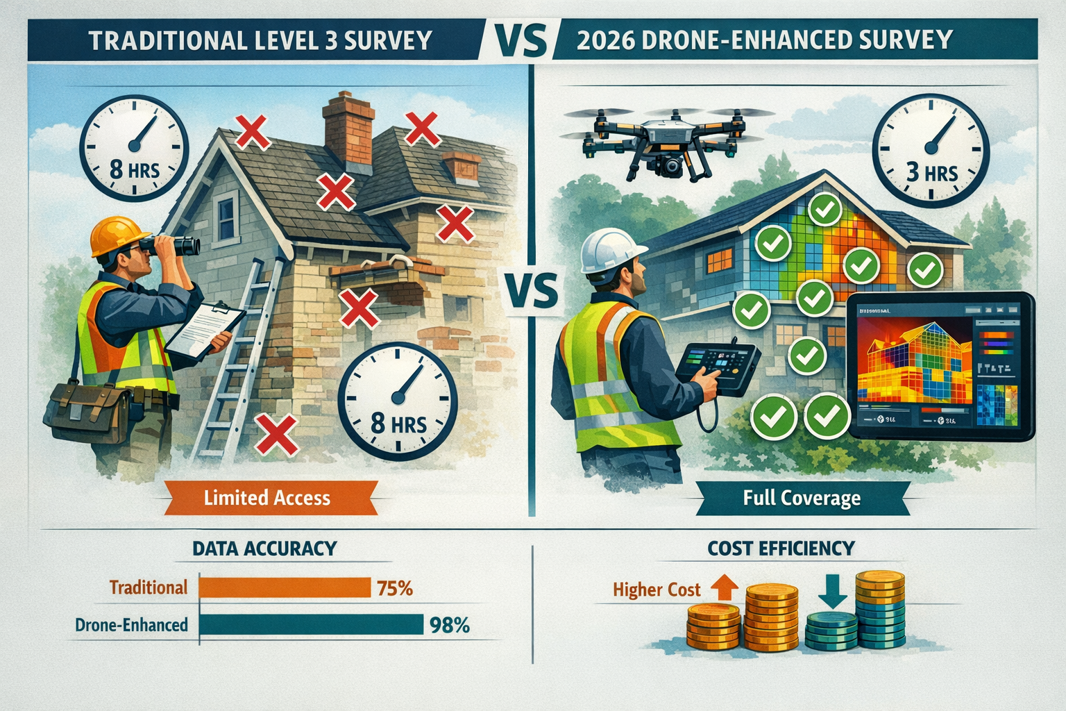
✅ Drone-enabled surveys reduce inspection time by 60% while providing comprehensive coverage of complex architectural features that traditional methods struggle to access
✅ Real-time thermal sensors detect hidden moisture and insulation defects before they become visible structural problems, preventing costly post-purchase surprises
✅ LiDAR technology creates precise 3D property models with millimeter accuracy, essential for documenting structural movement and settlement issues
✅ Integrated sensor data reduces valuation delays by providing immediate defect evidence to mortgage lenders and insurance underwriters
✅ Regulatory compliance improves as comprehensive digital documentation meets evolving RICS standards for Level 3 survey reporting
Understanding Level 3 Building Surveys and Their Complexity Requirements
A Level 3 Building Survey represents the most comprehensive property inspection available, designed specifically for older properties, buildings of unusual construction, or those requiring significant renovation work. Unlike basic Homebuyer Surveys, Level 3 assessments demand detailed investigation of every accessible part of the property structure.
Traditional Level 3 Survey Challenges:
- Access limitations: High-level features like chimney stacks, valley gutters, and dormer windows often require expensive scaffolding or aerial platforms
- Time constraints: Comprehensive manual inspections of complex properties can take 6-8 hours on-site, plus additional visits for inaccessible areas
- Documentation gaps: Traditional photography struggles to capture comprehensive roof conditions or detailed facade defects
- Safety concerns: Manual inspection of deteriorated structures poses significant risks to surveyors
- Weather dependencies: External inspections must wait for suitable conditions, delaying reports
These challenges become particularly acute when surveying:
🏛️ Heritage buildings with complex architectural details and multiple roof levels
🏢 Commercial conversions featuring unusual structural modifications
🏘️ Multi-unit developments requiring consistent assessment across numerous properties
🏚️ Dilapidated structures where safe physical access proves impossible
The integration of Real-Time Sensors and Drones in Level 3 Building Surveys: Enhancing 2026 Defect Detection for Complex Properties addresses each of these limitations systematically. Chartered surveyors can now conduct more thorough inspections in less time while maintaining the rigorous standards required for RICS compliance.
How Real-Time Sensor Technology Transforms Defect Detection
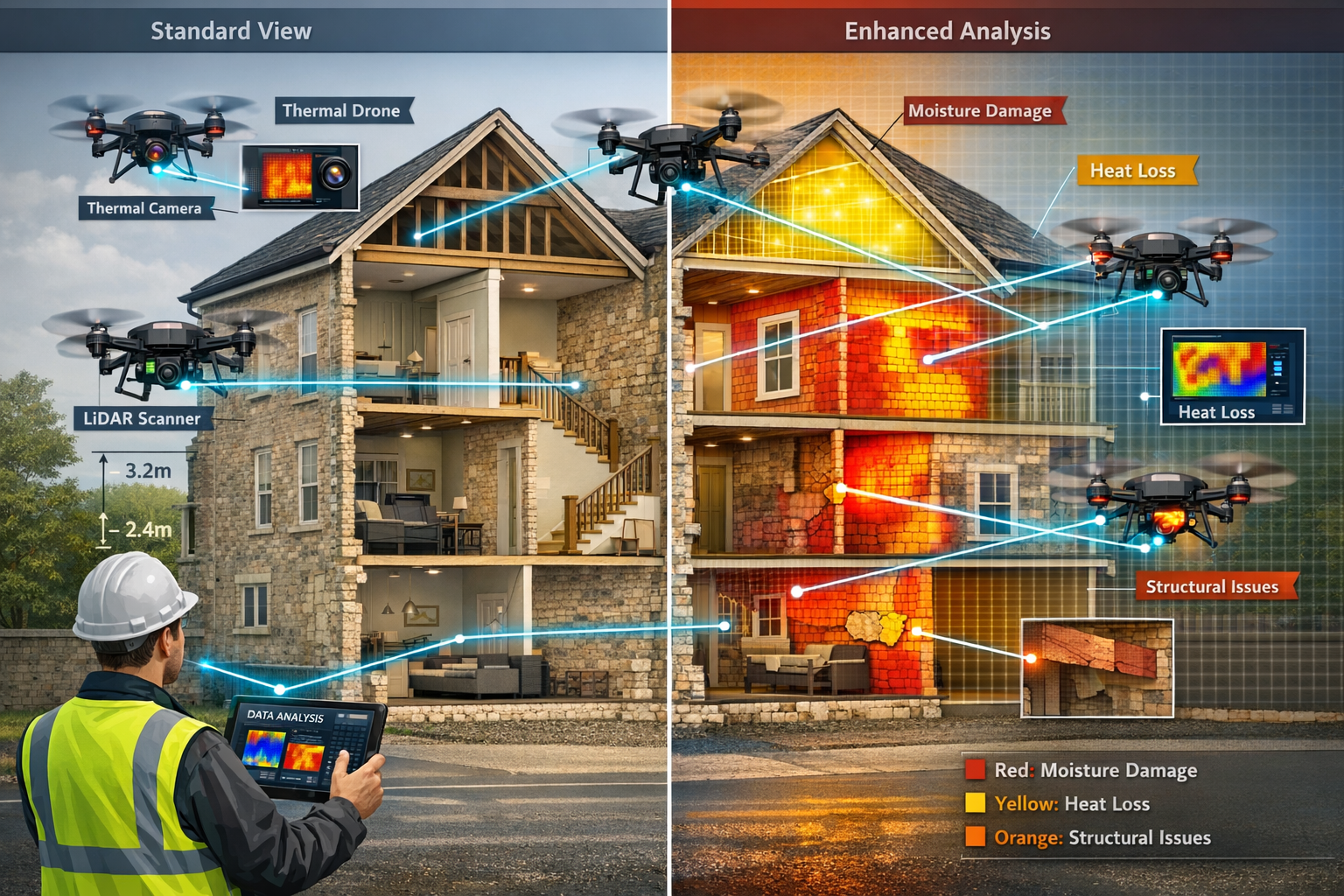
The sensor revolution in building surveys extends far beyond simple aerial photography. Modern surveying drones carry sophisticated sensor arrays that detect problems invisible to the human eye, providing quantifiable data that supports accurate defect diagnosis.
Thermal Imaging Sensors
Thermal cameras mounted on drones detect temperature variations across building surfaces, revealing:
Moisture penetration patterns: Cold spots indicate water ingress behind walls, under roofing materials, or within cavity walls—critical information for specific defect reports
Insulation failures: Heat loss visualization identifies missing or damaged insulation, particularly important for energy efficiency assessments
Air leakage paths: Temperature differentials highlight gaps in building envelope that compromise thermal performance
Hidden structural issues: Moisture-related temperature changes often precede visible rot or deterioration
Thermal drones for construction and surveying applications have become essential tools, with detection capabilities that identify defects weeks or months before they become visible problems [5]. This early detection capability proves invaluable for property valuations, as mortgage lenders increasingly require evidence of structural soundness before approving financing.
LiDAR Scanning Technology
Light Detection and Ranging (LiDAR) sensors create precise three-dimensional point clouds of building structures, capturing millions of measurement points in minutes. The state of drone LiDAR in 2026 shows remarkable advances in accuracy and processing speed [1].
LiDAR advantages for Level 3 surveys:
| Feature | Traditional Measurement | LiDAR Technology |
|---|---|---|
| Accuracy | ±50mm typical | ±10mm or better |
| Coverage speed | 100m² per hour | 2,000m² per hour |
| Vertical access | Requires scaffolding | Immediate drone access |
| Data completeness | Sample measurements | Complete 3D model |
| Settlement detection | Visual assessment | Millimeter-precision tracking |
LiDAR proves particularly valuable when assessing structural surveys requirements, as the technology documents existing conditions with forensic precision. This data becomes essential evidence if structural movement or settlement issues develop after purchase.
Moisture Detection Sensors
Advanced moisture sensors using microwave or infrared technology penetrate building surfaces to detect hidden dampness without physical contact. These sensors identify:
- Rising damp at foundation and ground floor levels
- Penetrating damp through walls, roofs, and around windows
- Condensation problems in poorly ventilated spaces
- Plumbing leaks hidden within wall cavities
Real-time moisture data allows surveyors to prioritize invasive investigations, reducing unnecessary destructive testing while ensuring critical damp issues receive appropriate attention.
High-Resolution Visual Cameras
Modern drone cameras capture 48-megapixel images with optical zoom capabilities, documenting:
✓ Roof tile condition and displacement
✓ Mortar deterioration and repointing requirements
✓ Chimney stack stability and flashing integrity
✓ Facade cracking patterns indicating structural movement
✓ Gutter and downpipe condition
The combination of visual documentation with sensor data provides comprehensive evidence for roof surveys and facade assessments that would traditionally require multiple scaffold erections.
Implementing Drone Technology in 2026 Level 3 Survey Protocols
The practical implementation of Real-Time Sensors and Drones in Level 3 Building Surveys: Enhancing 2026 Defect Detection for Complex Properties requires careful integration with established survey methodologies. Professional surveyors don't replace traditional inspection techniques—they enhance them with technology that improves accuracy and coverage.
Pre-Survey Planning and Equipment Selection
Choosing appropriate drone equipment depends on property characteristics and survey objectives. Tips for choosing the best drones for surveying in 2026 emphasize matching sensor capabilities to inspection requirements [6].
Equipment considerations:
For heritage properties: High-resolution cameras with optical zoom for detailed architectural documentation, thermal sensors for moisture detection in solid walls
For commercial buildings: LiDAR scanners for precise dimensional surveys, thermal imaging for HVAC and building envelope assessment
For complex roofing: Multi-spectral sensors detecting underlayment failures, high-resolution cameras for tile condition documentation
For structural concerns: LiDAR for settlement monitoring, thermal sensors for crack pattern analysis
The best drones for aerial survey and mapping in 2026 feature extended flight times (30-40 minutes), obstacle avoidance systems, and real-time data transmission to ground-based analysis tablets [7].
Survey Execution Workflow
Professional drone-enhanced Level 3 surveys follow structured protocols:
1. Ground-level traditional inspection (2-3 hours)
- Interior spaces, accessible exteriors, services, and structural elements
- Invasive investigations where appropriate
- Moisture meter readings and opening-up works
2. Drone sensor survey (45-90 minutes)
- Systematic coverage of roof areas, chimneys, and high-level features
- Thermal imaging passes for moisture and insulation assessment
- LiDAR scanning for dimensional accuracy and settlement detection
- High-resolution photography for defect documentation
3. Real-time data analysis (30-60 minutes)
- Immediate review of sensor data on-site
- Identification of areas requiring additional investigation
- Correlation of sensor findings with ground-level observations
4. Supplementary investigations (as required)
- Targeted opening-up based on sensor evidence
- Additional moisture testing in areas flagged by thermal imaging
- Structural calculations informed by precise LiDAR measurements
This integrated approach ensures that drone technology enhances rather than replaces the professional judgment central to RICS Chartered Building Surveyor expertise.
Regulatory Compliance and Professional Standards
Operating drones for commercial surveying requires adherence to Civil Aviation Authority (CAA) regulations and RICS professional standards. In 2026, over 1.7 million drones are registered in the United States alone, with commercial operations subject to strict licensing requirements [3].
Key compliance requirements:
📋 CAA operational authorization: Commercial drone pilots must hold appropriate licenses and maintain operational permissions
📋 Insurance coverage: Specialist drone liability insurance protects against equipment failure or operational incidents
📋 Data protection: Aerial surveys must respect privacy regulations, particularly in residential areas
📋 RICS reporting standards: Drone-captured data must be presented in formats that meet professional surveying documentation requirements
Professional surveyors integrating drone technology maintain traditional survey competencies while adding specialized technical skills. This ensures that Real-Time Sensors and Drones in Level 3 Building Surveys: Enhancing 2026 Defect Detection for Complex Properties maintains the rigorous standards clients expect from comprehensive property assessments.
Benefits of Enhanced Defect Detection for Property Transactions
The integration of real-time sensor technology and drone platforms delivers measurable benefits throughout the property transaction process, addressing pain points that have historically delayed completions and increased costs.
Reduced Valuation Delays
Traditional Level 3 surveys often require multiple site visits when initial inspections reveal areas requiring further investigation. Scaffolding erection for high-level access can add 2-3 weeks to survey timelines, directly impacting mortgage offer validity periods and completion dates.
Drone technology timeline improvements:
- Single-visit comprehensive coverage: Immediate access to all external areas eliminates return visits
- Real-time defect identification: Instant sensor data allows immediate assessment of problem severity
- Immediate lender communication: Digital evidence packages can be transmitted to mortgage valuers within hours
- Faster insurance underwriting: Comprehensive roof and structural documentation accelerates building insurance approvals
These efficiency gains prove particularly valuable in competitive property markets where transaction speed influences buyer success.
Enhanced Defect Documentation Quality
The combination of thermal imaging, LiDAR scanning, and high-resolution photography provides evidence quality that far exceeds traditional survey documentation. This comprehensive data supports:
Accurate repair cost estimation: Precise defect measurement enables detailed specification and accurate contractor quotations
Negotiation leverage: Objective sensor data provides irrefutable evidence when negotiating price reductions for identified defects
Future monitoring baselines: LiDAR models and thermal images establish precise baselines for tracking defect progression
Insurance claim support: Comprehensive pre-purchase documentation protects against disputes over pre-existing conditions
For properties requiring stock condition surveys or schedule of condition reporting, drone-captured data provides unambiguous evidence of property condition at specific dates.
Improved Safety and Risk Management
Drone deployment eliminates many physical risks associated with traditional high-level inspections:
⚠️ Reduced fall risks: Surveyors remain safely on ground level while drones access dangerous areas
⚠️ Unstable structure assessment: Drones can inspect deteriorated roofs and chimneys without loading fragile structures
⚠️ Hazardous material identification: Thermal sensors detect asbestos-containing materials without direct contact
⚠️ Weather-related incidents: Drone operations proceed safely in conditions that would make ladder work hazardous
This safety enhancement benefits both surveyors and property owners, reducing liability exposure while maintaining comprehensive inspection coverage.
Cost-Effectiveness Analysis
While drone-enhanced surveys require specialized equipment investment, the cost-benefit analysis favors technology adoption:
Cost comparison (typical complex property):
Traditional Level 3 Survey:
- Survey fee: £1,200-£1,800
- Scaffolding (if required): £800-£1,500
- Additional visits: £300-£500
- Timeline: 2-4 weeks
- Total cost: £2,300-£3,800
Drone-Enhanced Level 3 Survey:
- Survey fee: £1,400-£2,000
- No scaffolding required: £0
- Single comprehensive visit: Included
- Timeline: 3-7 days
- Total cost: £1,400-£2,000
The cost savings become more pronounced for properties with complex rooflines, multiple chimneys, or significant height, where traditional access costs escalate rapidly.
Future Developments in Building Survey Technology
The trajectory of Real-Time Sensors and Drones in Level 3 Building Surveys: Enhancing 2026 Defect Detection for Complex Properties points toward continued technological advancement that will further enhance diagnostic capabilities.
Artificial Intelligence Integration
Machine learning algorithms increasingly analyze sensor data automatically, identifying defect patterns that might escape human observation:
🤖 Automated crack detection: AI algorithms analyze high-resolution images to identify and measure structural cracks systematically
🤖 Thermal anomaly classification: Machine learning distinguishes between serious moisture issues and benign temperature variations
🤖 Predictive maintenance modeling: AI analyzes defect patterns to forecast deterioration timelines and maintenance requirements
🤖 Comparative analysis: Automated comparison of survey data against databases of similar properties identifies unusual conditions requiring investigation
These AI capabilities will augment rather than replace professional surveyor judgment, providing decision support that improves diagnostic accuracy.
Sensor Technology Advances
Emerging sensor technologies promise even more sophisticated defect detection:
Hyperspectral imaging: Multi-wavelength sensors detect material composition changes indicating deterioration or inappropriate repairs
Ground-penetrating radar: Drone-mounted GPR systems image subsurface conditions, detecting voids, services, and structural elements
Acoustic sensors: Ultrasonic testing identifies delamination, voids, and material degradation through sound wave analysis
Environmental monitoring: Integrated sensors measure air quality, radon levels, and electromagnetic fields during surveys
Regulatory Evolution
Professional standards continue evolving to incorporate technological capabilities. RICS guidance increasingly recognizes drone-captured data as meeting documentation requirements for Level 3 surveys, provided operators maintain appropriate qualifications and follow standardized protocols.
The drone road surveys and highway planning sector demonstrates how regulatory frameworks adapt to embrace technological innovation while maintaining safety and quality standards [2]. Similar evolution continues within building surveying, with professional bodies developing specific guidance for drone operations and sensor data interpretation.
Conclusion
Real-Time Sensors and Drones in Level 3 Building Surveys: Enhancing 2026 Defect Detection for Complex Properties represents a fundamental advancement in how building professionals assess structural integrity, identify hidden defects, and document property conditions. The integration of thermal imaging, LiDAR scanning, moisture detection, and high-resolution photography delivers comprehensive diagnostic data that traditional inspection methods cannot match—particularly for complex properties with difficult access requirements.
The benefits extend throughout the property transaction process: reduced valuation delays accelerate completions, enhanced documentation quality supports accurate repair cost estimation, improved safety protects surveyors and property owners, and cost-effectiveness makes comprehensive surveys accessible for more property types.
For property buyers, investors, and mortgage lenders, drone-enhanced Level 3 surveys provide confidence that hidden defects have been identified before financial commitment. The technology proves particularly valuable for heritage buildings, commercial conversions, and structurally complex properties where traditional inspection methods face significant limitations.
Next Steps for Property Stakeholders
For property buyers: When commissioning a Level 3 Building Survey, inquire whether surveyors utilize drone technology and real-time sensors. The enhanced diagnostic capabilities justify modest cost premiums through superior defect detection and faster completion timelines.
For property professionals: Evaluate drone-enhanced survey services for complex properties requiring comprehensive assessment. The technology delivers competitive advantages in transaction speed and documentation quality.
For surveyors: Consider integrating drone platforms and sensor technology into survey practices. The investment delivers operational efficiencies, enhanced service offerings, and improved client outcomes that justify equipment and training costs.
For mortgage lenders: Recognize drone-captured survey data as meeting documentation requirements for complex property valuations. The technology reduces assessment timelines while improving defect detection accuracy.
The convergence of professional surveying expertise with advanced sensor technology creates unprecedented capabilities for identifying building defects before they impact property values or transaction timelines. As regulatory frameworks continue evolving and technology costs decline, drone-enhanced Level 3 surveys will become standard practice for complex property assessments—delivering better outcomes for all stakeholders in the property transaction process.
References
[1] State Of Drone Lidar In 2026 – https://abjacademy.global/drone-blog/state-of-drone-lidar-in-2026/
[2] Drone Road Surveys Highway Planning 2026 – https://birdseyeaerialdrones.com/drone-road-surveys-highway-planning-2026/
[3] Drone Statistics – https://pilotinstitute.com/drone-statistics/
[4] Drone Surveying – https://uavcoach.com/drone-surveying/
[5] Thermal Drones For Construction – https://www.thedroneu.com/blog/thermal-drones-for-construction/
[6] Tips For Choosing The Best Drones For Surveying In 2026 – https://www.duncan-parnell.com/blog/101/tips-for-choosing-the-best-drones-for-surveying-in-2026
[7] Best Drones Aerial Survey Mapping 2026 – https://www.thefuture3d.com/blog/best-drones-aerial-survey-mapping-2026