A single misplaced boundary marker on a major infrastructure project can trigger cost overruns running into hundreds of thousands of pounds. That single fact explains why the surveying industry's shift toward real-time data in surveying: harnessing GNSS RTK and cloud platforms for instant on-site decisions is not a trend — it is a fundamental change in how accurate, fast, and accountable field work has become. In 2026, surveyors who rely on post-processed data collected days before a decision is needed are working at a competitive and technical disadvantage. This article explains how GNSS RTK technology delivers sub-inch positional accuracy, how cloud platforms transform raw field data into actionable intelligence, and why construction and infrastructure teams are adopting these tools at pace.
Key Takeaways
- GNSS RTK systems routinely achieve 1-2 cm horizontal accuracy in real time, eliminating the need for base stations or lengthy post-processing workflows.
- Cloud-connected survey platforms allow field data to be reviewed, validated, and acted upon by remote teams within seconds of capture.
- Network RTK correction services now stream corrections from over 20,000 reference stations across more than 145 countries, making global coverage practical.
- Integration with LiDAR, drones, and mobile devices is expanding RTK's reach beyond traditional survey roles into construction monitoring, landslide detection, and urban mapping.
- Chartered surveyors who understand these technologies can deliver faster, more defensible reports — a direct benefit to clients in fast-moving construction and property projects.

How GNSS RTK Achieves Sub-Inch Accuracy in the Field
Before examining cloud integration, it is worth understanding precisely what makes GNSS RTK so powerful at the hardware level. Real-Time Kinematic (RTK) positioning works by comparing carrier-phase signals received by a rover unit against a stream of correction data from a reference station or correction network. The result is positional accuracy measured in centimetres — or, in optimal conditions, sub-centimetre precision.
The Physics Behind Centimetre-Level Positioning
Standard GNSS receivers — including those in smartphones — calculate position by measuring the travel time of signals from satellites. This time-of-flight method introduces errors from atmospheric interference, satellite geometry, and multipath reflections. RTK eliminates most of these errors by sending real-time differential corrections to the rover. Because both the reference station and the rover observe the same satellite signals at the same moment, systematic errors largely cancel out.
Services such as Trimble VRS Now deliver instant access to network-RTK corrections via cellular signals, providing centimetre-level accuracy backed by continuous expert monitoring and built-in redundancy [5]. Similarly, RTKdata.com streams real-time NTRIP corrections from over 20,000 reference stations across 145+ countries, achieving 1-2 cm horizontal accuracy without requiring a dedicated on-site base station [2].
Network RTK vs. Traditional Base Station Setup
| Feature | Traditional Base Station | Network RTK |
|---|---|---|
| Setup time | 30-60 minutes | Under 5 minutes |
| Coverage radius | Typically 10-20 km | National or global |
| Equipment needed | Base + rover | Rover only |
| Correction latency | Seconds | Near-zero |
| Cost per survey | High (equipment transport) | Subscription-based |
The shift to network RTK is significant for fast-paced construction projects. A single rover connected to a correction network like HxGN SmartNet — which offers centimetre-level accuracy compatible with any GNSS device and extensive global coverage [1] — can operate across an entire project site without repositioning a base station as work progresses.
Addressing Urban and GNSS-Degraded Environments
Dense urban environments present a specific challenge: Non-Line-of-Sight (NLOS) signal errors caused by buildings reflecting satellite signals. Research published on arXiv demonstrates that integrating 3D LiDAR with GNSS significantly improves NLOS mitigation, enhancing the reliability of RTK positioning in urban canyons [8]. Additionally, factor graph optimisation methods have been developed that exploit the time-correlation of GNSS measurements, improving positioning accuracy in challenging environments where traditional RTK struggles [9].
For landslide and infrastructure monitoring, a GNSS-RTK system based on an improved Raida criterion has demonstrated real-time deformation monitoring with 10 mm accuracy in both horizontal and vertical directions — a level of precision that opens doors for continuous structural health monitoring on bridges, embankments, and slopes [7].
Cloud Platforms: Turning Field Data Into Instant On-Site Decisions
Accurate positioning data is only useful when the right people can act on it at the right time. This is where cloud platforms transform the workflow. The combination of real-time data in surveying — harnessing GNSS RTK and cloud platforms for instant on-site decisions — means that a site engineer in Manchester and a project director in London can view the same coordinate data within seconds of it being captured.
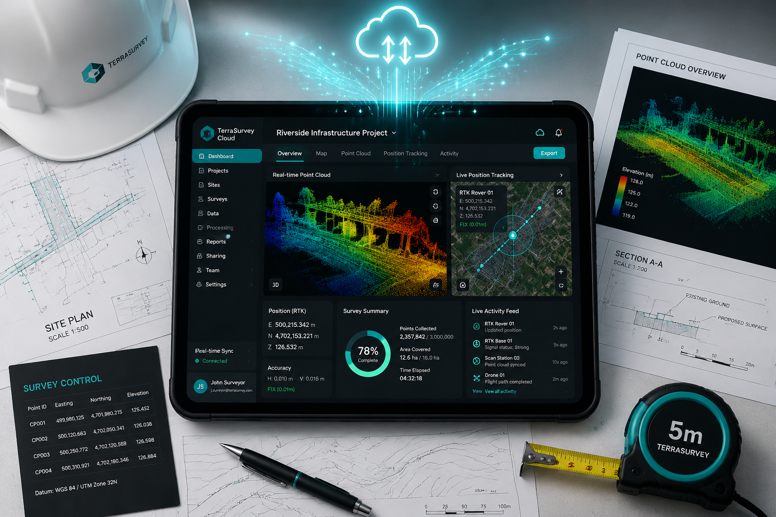
How Cloud-Connected Survey Workflows Operate
A typical cloud-connected RTK workflow in 2026 follows these steps:
- Capture — The rover records a position with centimetre-level accuracy.
- Transmit — Data is sent via cellular or Wi-Fi to a cloud platform in near real time.
- Process — The platform applies quality checks, flags outliers, and updates the project model.
- Distribute — Stakeholders receive notifications, updated drawings, or alerts on their devices.
- Decide — Engineers, surveyors, and project managers act on verified data without waiting for an office-based processing cycle.
This workflow eliminates the traditional "collect in the field, process in the office, report next day" cycle that has historically slowed construction decision-making.
Key Cloud Platform Capabilities
Aceinna's OpenARC platform illustrates the direction of travel: it integrates GNSS corrections with high-performance Inertial Navigation Systems (INS) and RTK hardware, delivering less than 10 cm accuracy with no latency. The platform is designed explicitly for construction, mapping, and surveying applications [3].
Nordian's Network-NTRIP service takes a cloud-first approach, delivering real-time GNSS corrections over the internet through a cloud-based network. This eliminates the need for on-site base stations entirely and provides centimetre-level accuracy across broad geographic areas [10].
"The value of real-time data is not just in its accuracy — it is in the speed at which a verified decision can be made. Waiting 24 hours for processed coordinates on a fast-track construction project is no longer acceptable."
Integration With BIM and Digital Twins
Modern cloud survey platforms increasingly connect with Building Information Modelling (BIM) environments and digital twin systems. When an RTK rover captures a point, that coordinate can automatically update a live 3D model of the project. Clashes between as-built conditions and design intent are flagged immediately, allowing corrective action before concrete is poured or steelwork is erected.
For RICS building surveys and structural surveys, this kind of real-time model updating provides a level of documentation and auditability that was previously impossible without significant post-processing effort.
Practical Applications: Construction, Infrastructure, and Beyond
The real-world impact of real-time data in surveying — harnessing GNSS RTK and cloud platforms for instant on-site decisions — is best understood through specific application areas where the technology is already delivering measurable results.

Fast-Track Construction Projects
On large construction programmes — highways, rail, housing developments — machine control systems use RTK positioning to guide excavators, graders, and pavers to millimetre-level tolerances without manual staking. The operator's cab display shows the machine's position relative to the design surface in real time. Rework rates fall dramatically.
For project management teams overseeing complex builds, RTK-enabled machine control reduces the surveyor's role from constant staking to periodic quality assurance checks, freeing skilled professionals for higher-value tasks.
Drone and Mobile Device Integration
Lefixea's LRTK platform demonstrates how RTK has expanded beyond traditional survey poles. The system integrates RTK technology with mobile devices, drones, and LiDAR systems, capturing absolute coordinates with up to half-inch accuracy [4]. For aerial surveys of large sites, this means drone-captured point clouds are georeferenced to centimetre accuracy without ground control points — a significant time saving on large infrastructure corridors.
MeasurNET provides an RTK network delivering centimetre-level correction signals specifically designed for drone flights and GNSS surveying, offering extensive coverage and reliable data transmission for aerial survey operations.
Monitoring and Geotechnical Applications
RTK is increasingly used for continuous deformation monitoring on slopes, retaining walls, and foundations. Because corrections are delivered in real time, a monitoring system can trigger alerts the moment a structure moves beyond a defined tolerance — rather than waiting for a weekly download and office analysis. Research into GNSS-RTK landslide monitoring systems has validated 10 mm accuracy in both horizontal and vertical directions for this type of application [7].
For dilapidation surveys and specific defect surveys where crack progression or settlement needs to be documented over time, RTK monitoring provides an objective, time-stamped record that supports legal and contractual positions.
Boundary and Cadastral Surveying
In boundary disputes and cadastral work, the ability to occupy a point and immediately confirm its coordinates against a national reference frame — without waiting for post-processing — speeds up the resolution of disagreements. Surveyors working on RICS home surveys and property valuations benefit from precise site measurement data that can be cross-referenced against title plans and OS mapping in real time.
For beam calculations and structural assessments where precise floor level data is required, RTK-derived spot heights provide a reliable, independently verifiable dataset.
Challenges, Limitations, and How to Address Them
No technology is without limitations, and a balanced assessment of RTK and cloud survey platforms requires acknowledging where the system can fail.
Signal Availability and Multipath
RTK requires a clear view of the sky and a reliable cellular or radio data link to receive corrections. In deep urban canyons, under tree canopy, or inside structures, signal quality degrades. The LiDAR-GNSS integration research cited earlier [8] represents one solution; another is the use of RTK-SLAM (Simultaneous Localisation and Mapping) systems that maintain accurate positioning even when GNSS signals are temporarily lost. A geodetically referenced dataset and evaluation methodology for RTK-SLAM systems has been developed specifically to address positioning in GNSS-degraded environments [6].
Data Security and Connectivity
Cloud-connected survey systems depend on reliable internet connectivity. On remote sites, this may require dedicated satellite broadband or LTE routers. Data security is also a consideration: survey data for infrastructure projects may be commercially sensitive or subject to national security restrictions. Reputable platforms offer encrypted data transmission and role-based access controls.
Skill and Training Requirements
RTK equipment has become significantly more user-friendly, but interpreting the data — understanding fixed versus float solutions, recognising multipath errors, validating network corrections — still requires trained professionals. RICS chartered building surveyors who invest in understanding these technologies are better placed to deliver defensible, accurate reports to clients.
Cost Considerations
Network RTK correction services operate on subscription models, which represent an ongoing cost. However, when compared against the cost of transporting, setting up, and monitoring a dedicated base station — and the risk cost of errors in post-processed data — the economics strongly favour network RTK for most commercial projects.
The Future Direction: AI, Automation, and Integrated Survey Ecosystems
The trajectory of real-time data in surveying — harnessing GNSS RTK and cloud platforms for instant on-site decisions — points toward increasing automation and artificial intelligence integration. In 2026, several developments are already visible:
- Automated quality control: Cloud platforms that apply machine learning to flag positional outliers, identify systematic errors, and recommend corrective action without human intervention.
- Predictive analytics: Using historical survey data and real-time monitoring feeds to predict settlement, deformation, or construction progress against programme.
- Autonomous survey robots: Ground-based robots and drones equipped with RTK receivers that conduct routine site surveys without a human operator, uploading data directly to cloud platforms.
- Seamless handover to asset management: Survey data captured during construction feeding directly into asset management systems for the operational life of the infrastructure.
For RICS reinstatement build cost valuations and commercial building surveys, the availability of high-accuracy as-built data captured during construction will increasingly inform post-construction assessments, reducing reliance on manual measurement and improving the accuracy of cost estimates.
Conclusion
The case for adopting real-time data in surveying — harnessing GNSS RTK and cloud platforms for instant on-site decisions — is built on measurable outcomes: faster project cycles, fewer errors, lower rework costs, and better-informed decisions at the moment they matter most. The technology is mature, globally available, and increasingly affordable.
Actionable next steps for surveying professionals and construction teams in 2026:
- Evaluate network RTK correction service providers against your geographic coverage requirements. Services like Trimble VRS Now [5], HxGN SmartNet [1], and RTKdata.com [2] each offer different coverage models and pricing structures.
- Audit your current data workflow to identify where the gap between field capture and office decision-making is costing time and money.
- Invest in training for field staff on fixed versus float RTK solutions and the interpretation of correction quality indicators.
- Pilot a cloud-connected survey platform on a single project before committing to a full rollout, using the pilot to establish data security protocols and connectivity requirements.
- Engage a RICS chartered surveyor with experience in digital survey methods to review your quality assurance framework and ensure that RTK-derived data meets the accuracy standards required for your specific project type.
The surveyors and construction teams that master this combination of satellite positioning and cloud intelligence will not simply work faster — they will work with a level of confidence and accountability that defines the standard for the industry going forward.
References
[1] hxgnsmartnet – https://hxgnsmartnet.com/?utm_source=openai
[2] Surveying – https://rtkdata.com/surveying/?utm_source=openai
[3] openarc.aceinna – https://openarc.aceinna.com/?utm_source=openai
[4] lefixea – https://www.lefixea.com/?utm_source=openai
[5] Trimble Vrs Now – https://geospatial.trimble.com/en/products/correction-services/trimble-vrs-now/?utm_source=openai
[6] arxiv – https://arxiv.org/abs/2604.07151?utm_source=openai
[7] arxiv – https://arxiv.org/abs/2301.05977?utm_source=openai
[8] arxiv – https://arxiv.org/abs/2212.05477?utm_source=openai
[9] arxiv – https://arxiv.org/abs/2106.01594?utm_source=openai
[10] Network Ntrip Service – https://www.nordian.com/network-ntrip-service?utm_source=openai