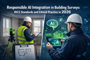
Imagine standing in a planning meeting where every stakeholder can see exactly how a proposed development will affect drainage patterns during a 100-year flood, or how a new building will cast shadows across neighboring properties throughout the seasons—all before breaking ground. This isn't science fiction; it's the transformative power of Real-Time 3D Digital Twins: Creating Interactive Land Models for Better Decision-Making in 2026.
The property development and urban planning landscape has fundamentally shifted. Static blueprints and traditional surveying methods can no longer keep pace with the complexity of modern land development challenges. Today's developers, planners, and surveyors are embracing high-fidelity, continuously-updating 3D models that function as living, breathing virtual entities mirroring physical land parcels in real-time.[1] These interactive digital twins capture every temperature change, structural movement, and environmental parameter instantly through IoT sensors and laser scanning technology, transforming how professionals visualize land behavior under various conditions and communicate with stakeholders.
The digital twin market is experiencing explosive growth, projected to surge from $16.75 billion in 2024 to an astounding $110.1 billion by 2029, with real estate and infrastructure sectors driving much of this expansion.[1] As we navigate through 2026, this technology is transitioning from experimental curiosity to essential operational tool, particularly in mission-critical sectors including higher education, healthcare, social housing, and large commercial real estate portfolios.[2]
Key Takeaways
✅ Real-time monitoring capabilities enable digital twins to function as living virtual entities that mirror physical land conditions instantly, capturing environmental changes, structural movements, and operational parameters through IoT sensors and laser scanning technology.
✅ Significant cost reductions of 10–20% in operating expenses are being achieved through improved predictive maintenance and performance monitoring, while reality capture technology delivers 20–50% efficiency improvements.[1]
✅ Democratized access to precision tools like NavVis VLX, Trimble X7, and iPad-based LiDAR scanners has transformed site documentation from specialist domain to everyday accessible technology for diverse construction and surveying teams.
✅ Data foundation prioritization over AI hype is critical in 2026, with industry experts emphasizing the need to centralize asset data, integrate systems, and ensure digital twins reflect real operational reality before implementing advanced capabilities.[2]
✅ Workflow automation integration through "twin-to-ticket" systems translates digital twin insights into actionable outcomes, demonstrating measurable results in energy reduction, decreased downtime, and faster response times.[2]
Understanding Real-Time 3D Digital Twins: Creating Interactive Land Models for Better Decision-Making
What Makes Digital Twins "Real-Time" and Interactive? 🔄
The fundamental distinction between traditional 3D models and real-time digital twins lies in their dynamic nature. While conventional architectural renderings remain frozen in time, digital twins continuously update to reflect current conditions on the ground. This transformation happens through sophisticated integration of multiple data streams:
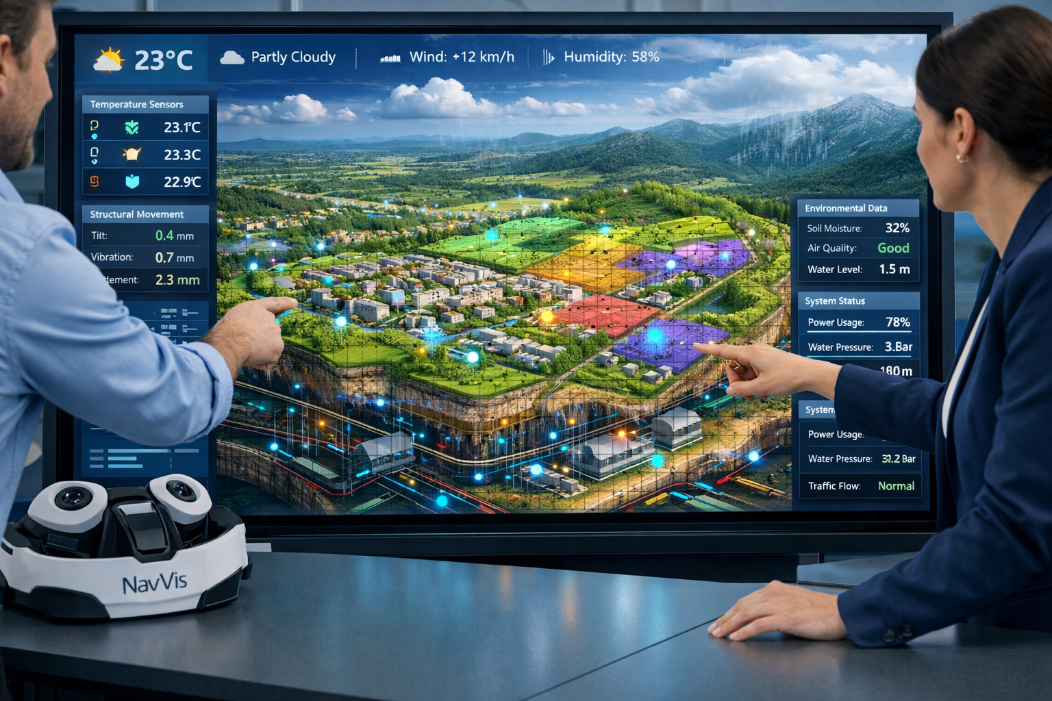
IoT Sensor Networks embedded throughout properties capture environmental data including:
- Temperature fluctuations across different zones
- Humidity levels affecting building materials
- Structural stress and movement measurements
- Energy consumption patterns
- Water flow and drainage conditions
- Air quality metrics
Laser Scanning Technology provides the geometric foundation with centimeter-level accuracy, creating point cloud data that serves as the validation layer for digital twins.[1] This regular scanning establishes a feedback loop maintaining virtual model accuracy over time, preventing digital twins from becoming what industry experts call "sophisticated guesswork."
Continuous Data Synchronization ensures that the virtual model reflects reality within minutes or even seconds of physical changes occurring. When a construction team completes a foundation pour, when weather conditions shift, or when equipment status changes, the digital twin updates accordingly.
The Technology Stack Behind Interactive Land Models
Creating effective real-time 3D digital twins requires a sophisticated technology ecosystem. The democratization of reality capture tools has been particularly transformative in 2026. A new generation of mobile devices—including NavVis VLX, Trimble X7, and iPad-based LiDAR scanners—has made precise site documentation accessible to VDC teams, superintendents, and subcontractors who previously relied on specialist consultants.[1]
| Technology Component | Function | Accuracy Level | Update Frequency |
|---|---|---|---|
| LiDAR Scanning | Geometric capture | ±5mm | Weekly/Monthly |
| IoT Sensors | Environmental monitoring | Varies by sensor | Real-time (seconds) |
| Photogrammetry | Visual documentation | ±10mm | As needed |
| BIM Integration | Design data foundation | Design accuracy | Project milestones |
| GIS Integration | Spatial context | Survey-grade | Quarterly |
| Cloud Processing | Data synthesis | N/A | Continuous |
The integration between these components creates what industry leaders describe as an operating layer rather than just a model.[2] This distinction is crucial—digital twins in 2026 aren't merely visualization tools but functional platforms enabling operators to work faster, more confidently, and more proactively.
From Static Blueprints to Dynamic Virtual Replicas
Property developers have moved decisively beyond static blueprints to embrace dynamic virtual replicas that continuously update throughout all project lifecycle stages from initial design through completion and ongoing operations.[4] This evolution addresses fundamental limitations of traditional documentation:
Traditional Approach Limitations:
- Information becomes outdated immediately after creation
- No connection between design intent and as-built reality
- Stakeholder communication relies on interpretation of 2D drawings
- Change management requires manual documentation updates
- Performance prediction based on theoretical models only
Digital Twin Advantages:
- Continuous validation against actual conditions
- Immediate visibility of design-to-reality variations
- Immersive stakeholder experiences with scenario modeling
- Automated change documentation and version control
- Performance monitoring with real operational data
When conducting building surveys, surveyors can now overlay historical scan data with current conditions to identify structural changes with unprecedented precision. This capability proves particularly valuable for subsidence surveys where millimeter-level movement detection over time provides critical evidence for insurance claims and remediation planning.
Applications of Real-Time 3D Digital Twins: Creating Interactive Land Models for Better Decision-Making Across Industries
Property Development and Construction Management
The construction industry has emerged as one of the strongest adopters of digital twin technology in 2026. Companies implementing these systems report 10–20% reductions in operating costs through improved predictive maintenance and performance monitoring, while reality capture technology delivers 20–50% improvements in efficiency and cost reductions of up to 20%.[1]
Pre-Construction Planning:
Digital twins enable developers to test multiple site configurations before committing to designs. By modeling how proposed structures interact with existing topography, drainage patterns, solar exposure, and neighboring properties, development teams identify potential issues early when changes cost least to implement.
For example, when planning a residential development, teams can simulate:
- Stormwater runoff under various rainfall scenarios
- Shadow impact on adjacent properties throughout the year
- Traffic flow patterns with proposed access routes
- Utility infrastructure capacity and connection points
- Construction logistics and staging areas
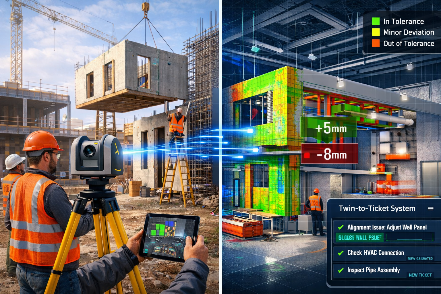
Construction Progress Monitoring:
Regular laser scanning creates an as-built record that automatically compares to design intent. Construction teams use these digital twin verification systems to adapt prefabricated elements to actual site conditions, maintaining quality standards while accommodating real-world construction variations.[1]
The workflow typically involves:
- Weekly scanning of active construction zones
- Automated comparison between point cloud data and BIM models
- Deviation reporting highlighting areas outside tolerance
- Coordination meetings addressing significant variations
- Documentation updates maintaining accurate as-built records
This process proves invaluable for commercial building surveys where large-scale projects involve multiple trades working simultaneously. The digital twin serves as a single source of truth preventing coordination conflicts and rework.
Prefabrication Integration:
Off-site manufacturing requires precise dimensional data to ensure components fit when delivered to site. Digital twins provide the validation layer confirming that actual site conditions match the measurements used for prefabrication shop drawings. When variations exist, teams can adjust fabrication parameters before manufacturing begins, avoiding costly field modifications.[1]
Urban Planning and Smart City Development 🏙️
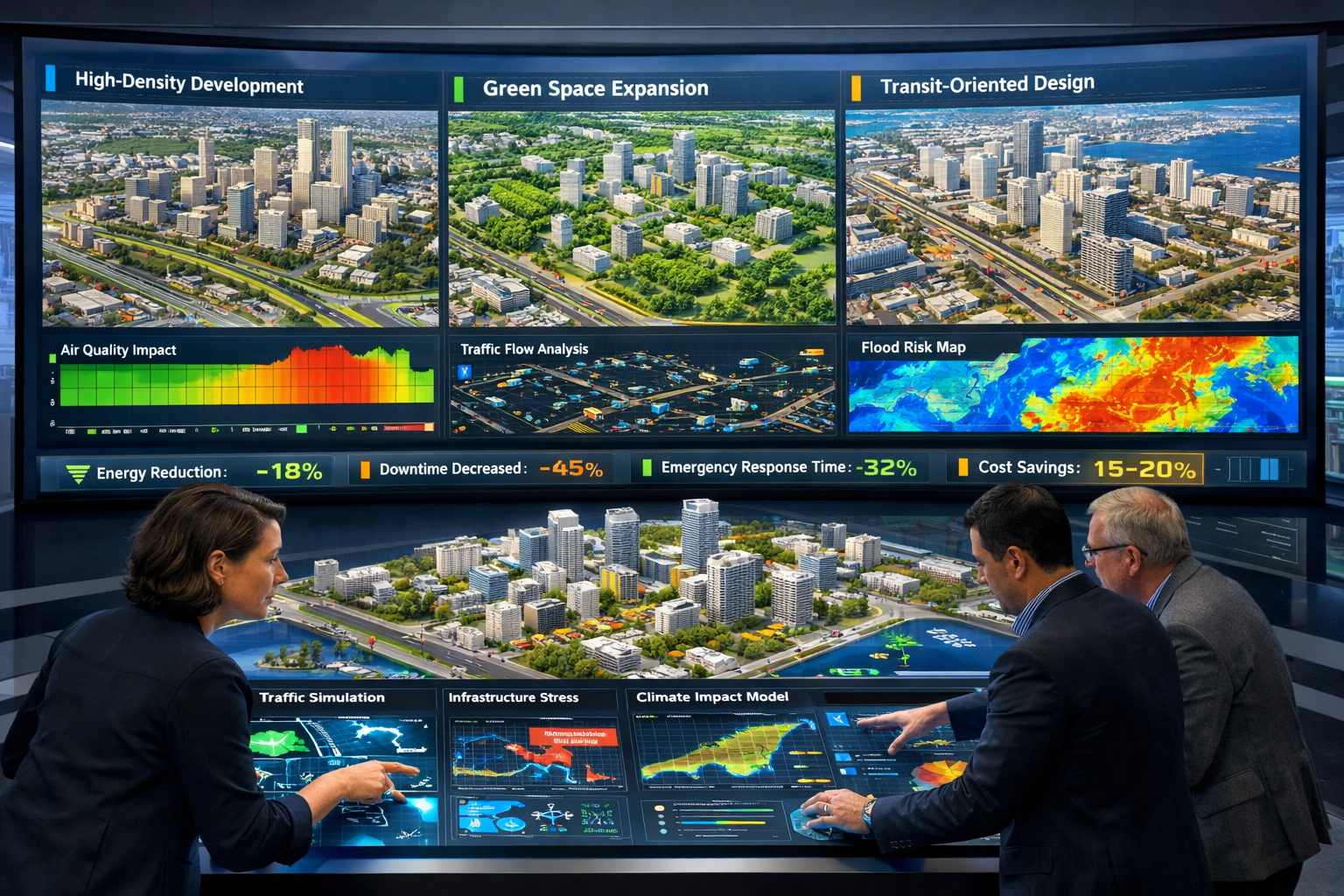
Urban planners face unprecedented challenges from rapid urbanization, aging infrastructure, and climate change impacts. Digital twins enable scenario modeling for testing zoning changes, transport strategies, and development proposals through real-time, data-driven models.[5]
Comprehensive City-Scale Models:
Forward-thinking municipalities are creating digital twins of entire districts or cities, integrating:
- Building footprints and heights from aerial LiDAR
- Underground utility networks from as-built records
- Transportation infrastructure including roads, transit, cycling routes
- Environmental sensors monitoring air quality, noise, temperature
- Real-time traffic and pedestrian movement data
- Historical performance data for infrastructure assets
These comprehensive models transform public consultation processes. Instead of reviewing static renderings, community members can explore proposed developments within accurate context, understanding true visual impact from multiple vantage points and under different lighting conditions.
Infrastructure Asset Management:
Municipalities managing extensive property portfolios use digital twins for proactive maintenance planning. By monitoring structural conditions, environmental stresses, and usage patterns across hundreds of buildings, facilities managers prioritize maintenance investments based on actual need rather than fixed schedules.
The structural engineering applications prove particularly valuable for aging infrastructure where detailed condition assessment guides renovation versus replacement decisions.
Climate Resilience Planning:
Digital twins enable cities to model climate change impacts including:
- Flood risk under various sea-level rise scenarios
- Urban heat island effects from different development patterns
- Stormwater management capacity during extreme weather events
- Green infrastructure effectiveness for temperature moderation
This capability supports evidence-based policy decisions around zoning, building codes, and infrastructure investment priorities.
Real Estate Portfolio Management and Operations
Large real estate portfolios—including universities, healthcare systems, corporate campuses, and social housing providers—represent some of the strongest digital twin adopters in 2026.[2] These organizations manage complex building ecosystems where operational efficiency directly impacts financial performance and service delivery.
Predictive Maintenance:
Rather than reactive repairs or time-based preventive maintenance, digital twins enable truly predictive approaches. By monitoring equipment performance patterns, environmental conditions, and usage intensity, facilities teams receive alerts when systems show early signs of degradation—before failures occur.
"A well-designed digital twin in 2026 should function as an operating layer rather than just a model, enabling operators to work faster, more confidently, and more proactively."[2]
Energy Performance Optimization:
Real-time monitoring of energy consumption across building zones identifies optimization opportunities. Digital twins correlate energy use with occupancy patterns, weather conditions, and equipment operation, revealing inefficiencies invisible in monthly utility bills.
Organizations implementing these capabilities report measurable outcomes including:
- 15–25% energy consumption reductions through optimized HVAC scheduling
- 30–40% faster response times to comfort complaints
- 20–35% decreased equipment downtime through predictive maintenance
- 10–15% lower overall operating costs
Space Utilization Analysis:
Understanding how building spaces are actually used—versus how they're intended to be used—informs renovation priorities and lease decisions. Occupancy sensors integrated with digital twins reveal underutilized areas that could be repurposed or consolidated, reducing overall real estate footprint.
For organizations conducting RICS building surveys or RICS homebuyer surveys, digital twin data provides comprehensive property condition documentation supporting valuation and transaction processes.
Environmental and Land Management
Environmental consultants and land managers leverage digital twins for monitoring ecological conditions and regulatory compliance across large land holdings.
Environmental Monitoring:
Sensor networks track environmental parameters including:
- Soil moisture and temperature at various depths
- Groundwater levels and flow patterns
- Vegetation health through multispectral imaging
- Wildlife movement and habitat usage
- Air and water quality metrics
This data supports evidence-based land management decisions and demonstrates regulatory compliance. Ground water sampling programs integrate seamlessly with digital twin platforms, creating comprehensive environmental baselines and tracking remediation progress.
Agricultural Applications:
Precision agriculture increasingly relies on digital twin technology for optimizing crop production. Real-time monitoring of soil conditions, weather patterns, and plant health enables targeted interventions—applying water, fertilizer, and pesticides only where and when needed rather than blanket applications.
Implementing Real-Time 3D Digital Twins: Creating Interactive Land Models for Better Decision-Making Successfully
Data Foundation: The Critical First Step
Industry experts consistently emphasize that 2026 should focus on establishing proper data foundations before pursuing advanced AI capabilities.[2] The temptation to jump directly to artificial intelligence and machine learning applications proves counterproductive when underlying data quality issues exist.
Essential Data Foundation Elements:
1. Centralized Asset Data Repository
All property and infrastructure information must reside in a single, accessible system. This includes:
- Original design documents and as-built drawings
- Equipment specifications and maintenance histories
- Warranty information and service contracts
- Previous inspection and survey reports
- Utility connection details and capacities
2. System Integration
Digital twins derive value from connecting previously siloed systems:
- Building Management Systems (BMS)
- Computerized Maintenance Management Systems (CMMS)
- Geographic Information Systems (GIS)
- Building Information Modeling (BIM) platforms
- Financial and procurement systems
- IoT sensor networks
3. Data Quality and Cleaning
Asset structure must accurately reflect operational reality. This often requires significant effort cleaning legacy data:
- Reconciling equipment inventories with actual installations
- Updating spatial locations for moved or replaced assets
- Standardizing naming conventions across systems
- Validating sensor calibrations and data quality
- Removing duplicate or obsolete records
4. Governance and Maintenance Processes
Data quality degrades without ongoing governance:
- Clear ownership and accountability for data accuracy
- Standardized processes for updating information
- Regular audits comparing digital records to physical reality
- Training programs ensuring consistent data entry
- Version control and change management protocols
Organizations that invest time establishing these foundations create digital twins that deliver reliable insights. Those that skip this foundational work end up with impressive visualizations built on questionable data—a situation industry experts describe as "garbage in, garbage out" regardless of how sophisticated the analytics layer becomes.
Reality Capture Workflow Integration
The democratization of reality capture tools means more team members can contribute to digital twin accuracy. However, this accessibility requires standardized workflows ensuring consistent quality.
Establishing Capture Protocols:
Frequency Determination:
Different project types and phases require different scanning frequencies:
- Active construction: Weekly scans of work areas
- Renovation projects: Before, during, and after scans
- Operational facilities: Quarterly or annual validation scans
- Infrastructure monitoring: Monthly scans of critical assets
- Dispute documentation: Immediate scans when issues arise
Quality Standards:
Capture specifications should define:
- Required point cloud density (points per square meter)
- Acceptable accuracy tolerances
- Overlap requirements between scan positions
- Environmental conditions suitable for scanning
- Registration accuracy for multi-scan projects
Processing Workflows:
Raw scan data requires processing before integration:
- Registration aligning multiple scans into unified coordinate system
- Cleaning removing noise, artifacts, and irrelevant objects
- Classification identifying different element types (walls, floors, equipment)
- Comparison analyzing deviations from design or previous scans
- Integration incorporating validated data into digital twin platform
For professionals conducting schedule of condition reporting, laser scanning provides objective, comprehensive documentation that eliminates disputes about pre-existing conditions. The point cloud data serves as irrefutable evidence of property state at specific moments in time.
Workflow Automation and Action Integration
The most successful digital twin implementations in 2026 emphasize translating insights into action through workflow integration and "twin-to-ticket" automation capabilities.[2] Visualization alone provides limited value; the platform must demonstrate measurable outcomes through automated responses to detected conditions.
Automated Workflow Examples:
Maintenance Ticket Generation:
When sensors detect conditions outside normal parameters, the system automatically:
- Creates maintenance work order with relevant details
- Assigns ticket to appropriate technician based on skills and location
- Includes digital twin context showing exact equipment location
- Attaches historical performance data and maintenance records
- Escalates if response doesn't occur within defined timeframe
Energy Optimization:
Real-time monitoring triggers automated responses:
- Adjusting HVAC setpoints based on occupancy and weather
- Shutting down equipment in unoccupied zones
- Shifting loads to off-peak hours when possible
- Alerting to unusual consumption patterns indicating issues
Security and Access Control:
Integration with building security systems enables:
- Automated lockdown procedures during emergencies
- Access restriction to areas with detected hazards
- Visitor routing to appropriate destinations
- Evacuation route optimization based on incident location
Compliance Documentation:
Regulatory requirements often demand specific documentation:
- Automated generation of inspection reports
- Compliance tracking against permit conditions
- Environmental monitoring data compilation
- Safety incident documentation and analysis
These automated workflows transform digital twins from passive monitoring tools into active operational platforms that reduce manual effort while improving response consistency.
Stakeholder Communication and Collaboration 🤝
Perhaps the most transformative aspect of Real-Time 3D Digital Twins: Creating Interactive Land Models for Better Decision-Making lies in revolutionizing stakeholder communication. Complex technical information becomes accessible to non-technical audiences through immersive visualization.
Development Approval Processes:
Planning authorities and community groups can explore proposed developments interactively:
- Walking through virtual spaces at human scale
- Viewing developments from neighboring properties
- Seeing seasonal shadow impacts throughout the year
- Understanding traffic flow and access arrangements
- Comparing multiple design alternatives side-by-side
This transparency reduces opposition based on misunderstanding while enabling legitimate concerns to be addressed through design modifications before approvals are granted.
Investment and Financing Decisions:
Financial stakeholders gain confidence through comprehensive project visualization:
- Understanding development complexity and risks
- Monitoring construction progress against schedules
- Verifying quality standards are being maintained
- Assessing asset condition for acquisition decisions
- Evaluating operational performance of existing properties
For professionals providing valuation of commercial property services, digital twins offer unprecedented insight into asset condition, operational efficiency, and remaining useful life—factors that significantly impact valuation conclusions.
Tenant and Occupant Engagement:
Building occupants benefit from understanding their environments:
- Wayfinding assistance in complex facilities
- Real-time information about amenity availability
- Maintenance schedules and impact notifications
- Energy consumption feedback promoting conservation
- Emergency evacuation procedures and routes
Overcoming Implementation Challenges
Technical Integration Complexity
Implementing comprehensive digital twin platforms requires integrating diverse technologies that weren't designed to work together. Legacy building management systems, modern IoT sensors, GIS databases, and BIM models each use different data formats, coordinate systems, and communication protocols.
Integration Strategies:
Middleware Platforms:
Specialized integration platforms serve as translators between systems, normalizing data formats and providing unified APIs for digital twin applications to consume.
Open Standards Adoption:
Industry standards including IFC (Industry Foundation Classes) for BIM data, Brick Schema for building systems, and OGC standards for geospatial data facilitate interoperability when vendors support them.
Phased Implementation:
Rather than attempting comprehensive integration immediately, successful organizations adopt phased approaches:
- Phase 1: Establish geometric foundation through reality capture
- Phase 2: Integrate critical operational systems (BMS, energy)
- Phase 3: Add IoT sensor networks for real-time monitoring
- Phase 4: Implement analytics and automation capabilities
- Phase 5: Expand to advanced AI and predictive features
This phased approach delivers value incrementally while managing complexity and allowing teams to develop necessary skills progressively.
Data Privacy and Security Considerations
Digital twins aggregate sensitive information about properties, operations, and sometimes occupants. This concentration of data creates security responsibilities and privacy considerations.
Security Measures:
- Access controls limiting data visibility based on roles
- Encryption for data in transit and at rest
- Audit logging tracking who accessed what information when
- Network segmentation isolating operational technology from IT networks
- Regular security assessments identifying vulnerabilities
Privacy Protections:
When occupancy sensors and other monitoring technologies track human activity, privacy safeguards become essential:
- Aggregating data to remove individual identification
- Limiting retention periods for detailed tracking data
- Transparent communication about what's monitored and why
- Opt-out mechanisms where appropriate
- Compliance with data protection regulations (GDPR, etc.)
Cost and ROI Justification 💰
Digital twin implementation requires significant investment in technology, data preparation, and organizational change. Justifying these costs demands clear articulation of expected benefits and realistic ROI projections.
Typical Cost Components:
- Reality capture equipment and software licenses
- IoT sensor networks and installation
- Digital twin platform subscription fees
- System integration and customization
- Data migration and cleaning efforts
- Staff training and change management
- Ongoing maintenance and updates
Quantifiable Benefits:
Organizations successfully securing funding emphasize measurable outcomes:
- Operating cost reductions (10–20% documented in industry studies)[1]
- Energy savings (15–25% through optimization)
- Maintenance efficiency (20–35% reduction in equipment downtime)
- Construction cost avoidance (catching coordination conflicts before field installation)
- Faster project delivery (20–50% efficiency improvements from reality capture)[1]
- Reduced insurance premiums (demonstrating proactive risk management)
- Higher asset values (premium pricing for smart buildings)
Intangible Benefits:
Some advantages prove harder to quantify but remain significant:
- Improved stakeholder communication and buy-in
- Enhanced organizational reputation and competitiveness
- Better decision-making through comprehensive information
- Reduced regulatory compliance risks
- Improved occupant satisfaction and productivity
When conducting comparing different types of survey exercises, organizations should consider how digital twin data might enhance traditional survey deliverables, potentially justifying premium fees for technology-enhanced services.
Skills and Organizational Change
Technology implementation succeeds or fails based on human factors. Digital twins require new skills and often challenge established workflows and organizational structures.
Required Skill Development:
Technical Skills:
- Reality capture operation and data processing
- Digital twin platform administration
- Data analysis and visualization
- IoT sensor configuration and troubleshooting
- System integration and API management
Analytical Skills:
- Interpreting sensor data and identifying anomalies
- Scenario modeling and simulation
- Performance benchmarking and optimization
- Root cause analysis for operational issues
Communication Skills:
- Translating technical data for non-technical audiences
- Stakeholder presentation and consultation
- Cross-functional collaboration
- Change management and training delivery
Training Approaches:
Successful organizations invest in comprehensive training programs:
- Vendor training on specific platforms and tools
- Internal champions developing deep expertise to support colleagues
- Hands-on projects providing practical experience
- External courses in relevant technical domains
- Cross-training ensuring knowledge isn't concentrated in single individuals
Organizational Change Management:
Technology adoption requires addressing cultural resistance:
- Executive sponsorship demonstrating leadership commitment
- Clear communication about why change is occurring and benefits expected
- Involvement of end users in design and implementation decisions
- Quick wins demonstrating value early in implementation
- Recognition of individuals embracing new approaches
- Patience acknowledging that cultural change takes time
Future Directions and Emerging Trends
Artificial Intelligence and Machine Learning Integration
While industry experts emphasize getting data foundations right before pursuing AI capabilities,[2] the integration of artificial intelligence with digital twins represents a significant opportunity once those foundations exist.
Predictive Analytics:
Machine learning models trained on historical performance data can predict:
- Equipment failures before they occur
- Energy consumption patterns under various conditions
- Optimal maintenance schedules based on usage intensity
- Space utilization trends informing planning decisions
- Construction progress and completion dates
Automated Anomaly Detection:
AI systems excel at identifying unusual patterns in complex datasets:
- Sensor readings outside normal ranges
- Performance degradation trends
- Security or safety concerns
- Energy waste opportunities
- Quality issues during construction
Natural Language Interfaces:
Conversational AI enables non-technical users to query digital twins:
- "Show me all HVAC equipment due for maintenance this month"
- "What's the temperature in conference room 3B?"
- "Which buildings have the highest energy costs per square foot?"
- "Alert me when construction progress falls behind schedule"
Extended Reality (XR) Visualization
Virtual reality (VR), augmented reality (AR), and mixed reality (MR) technologies enhance how users interact with digital twins.
Virtual Reality Applications:
Immersive VR experiences enable:
- Design review meetings where stakeholders "walk through" proposed developments
- Training simulations for equipment operation and emergency procedures
- Remote site visits for stakeholders unable to travel
- Historical comparisons showing how properties have changed over time
Augmented Reality Applications:
AR overlays digital information onto physical environments:
- Construction workers seeing BIM models overlaid on actual site conditions
- Maintenance technicians viewing equipment specifications and procedures
- Surveyors visualizing underground utilities before excavation
- Property managers seeing sensor data overlaid on physical equipment
Mixed Reality Applications:
MR combines physical and digital elements for collaborative work:
- Design teams manipulating virtual building elements in physical space
- Remote experts providing guidance overlaid on local technician's view
- Interactive planning sessions with holographic models
These visualization technologies make digital twins accessible to broader audiences, democratizing access to complex spatial information.
Integration with Broader Smart City Ecosystems
Individual building digital twins increasingly connect to broader urban-scale platforms, creating comprehensive smart city ecosystems.
Multi-Scale Integration:
Digital twins operating at different scales interconnect:
- Building level: Individual property operations and performance
- Campus level: Multiple buildings with shared infrastructure
- District level: Neighborhoods with interconnected systems
- City level: Comprehensive urban infrastructure and services
- Regional level: Transportation, utilities, and environmental systems
This multi-scale integration enables optimization across boundaries:
- District energy systems balancing supply and demand across buildings
- Transportation planning considering building occupancy patterns
- Emergency response coordinating across multiple facilities
- Environmental monitoring tracking pollution sources and impacts
Public-Private Data Sharing:
Smart city success requires appropriate data sharing between public authorities and private property owners:
- Buildings sharing energy consumption data for grid optimization
- Traffic sensors informing development access planning
- Environmental monitoring contributing to air quality management
- Emergency systems coordinating evacuation procedures
Establishing governance frameworks for this data sharing—balancing public benefit with privacy protection and competitive concerns—represents an ongoing challenge requiring thoughtful policy development.
Conclusion
Real-Time 3D Digital Twins: Creating Interactive Land Models for Better Decision-Making represents far more than technological novelty—it's a fundamental transformation in how professionals understand, manage, and optimize land and property assets. The shift from static documentation to dynamic, continuously-updating virtual replicas enables decision-making based on actual conditions rather than outdated assumptions or theoretical models.
The evidence supporting digital twin adoption continues strengthening. Organizations implementing these technologies report 10–20% reductions in operating costs, 20–50% efficiency improvements in construction processes, and measurable gains in energy performance, maintenance effectiveness, and stakeholder satisfaction.[1] As the market expands from $16.75 billion in 2024 toward $110.1 billion by 2029,[1] digital twins are transitioning from competitive advantage to operational necessity across real estate, infrastructure, and urban planning sectors.
Success in 2026 and beyond requires focusing on fundamentals before pursuing advanced capabilities. Organizations must prioritize establishing solid data foundations—centralizing asset information, integrating systems, cleaning legacy data, and implementing governance processes ensuring ongoing accuracy.[2] These unglamorous foundational efforts determine whether digital twins deliver reliable insights or become sophisticated visualizations built on questionable data.
The democratization of reality capture tools has made precision documentation accessible to diverse team members, but this accessibility demands standardized workflows ensuring consistent quality. Regular laser scanning with centimeter-level accuracy provides the validation layer preventing digital twins from drifting away from physical reality.[1]
Perhaps most importantly, successful implementations emphasize translating insights into action through workflow automation and "twin-to-ticket" systems.[2] Digital twins must function as operating layers enabling faster, more confident, and more proactive work—not merely visualization tools generating impressive images.
Actionable Next Steps
For organizations considering or implementing digital twin technology:
-
Assess current data maturity – Conduct honest evaluation of existing asset data quality, system integration, and governance processes before pursuing advanced visualization.
-
Start with focused pilot projects – Identify specific use cases with clear ROI potential rather than attempting comprehensive implementation immediately. Successful pilots build organizational confidence and demonstrate value.
-
Invest in reality capture capabilities – Whether purchasing equipment or engaging chartered surveyors with advanced scanning capabilities, establish regular documentation workflows creating the geometric foundation for digital twins.
-
Prioritize workflow integration – Focus on connecting digital twin insights to operational systems through automated ticket generation, alert mechanisms, and decision support tools that drive measurable outcomes.
-
Develop organizational capabilities – Invest in training programs building necessary technical, analytical, and communication skills across teams. Technology succeeds only when people can effectively use it.
-
Engage stakeholders early – Use digital twin visualization capabilities to improve communication with planning authorities, community groups, investors, and occupants. Transparency builds trust and support.
-
Plan for scalability – Design implementations with future expansion in mind, selecting platforms and standards that enable growth from building-level to campus-level to district-level integration.
The future of property development, construction management, urban planning, and facilities operations increasingly depends on high-fidelity virtual replicas that enable testing scenarios, predicting outcomes, and optimizing performance before committing resources to physical changes. Organizations embracing Real-Time 3D Digital Twins: Creating Interactive Land Models for Better Decision-Making position themselves to navigate complexity, manage risk, and deliver superior outcomes in an increasingly demanding built environment.
References
[1] Virtual Design Construction Vdc Trends 2026 Ai Digital Twins Technology – https://www.clearedge3d.com/blogs/virtual-design-construction-vdc-trends-2026-ai-digital-twins-technology/
[2] What Do Digital Twins Hold For 2026 From Visualisation To Smart Building Operations – https://www.twinview.com/insights/what-do-digital-twins-hold-for-2026-from-visualisation-to-smart-building-operations
[3] Real Estate – https://matterport.com/learn/digital-twin/real-estate
[4] Real Time 3d Digital Twins For Property Development Interactive Models That Update Live – https://nottinghillsurveyors.com/blog/real-time-3d-digital-twins-for-property-development-interactive-models-that-update-live
[5] Digital Twin Urban Planning – https://www.toobler.com/blog/digital-twin-urban-planning
[6] The 2026 Aec Technology Bim Ai Digital Twins – https://www.teslaoutsourcingservices.com/blog/the-2026-aec-technology-bim-ai-digital-twins/
[7] Digital Twins – https://darlingltd.com/services/digital-twins/