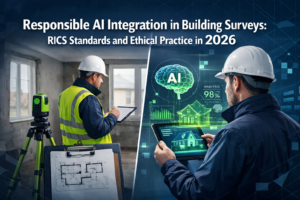
When a surveyor walks through a property today, they're no longer working alone. Behind the scenes, artificial intelligence and machine learning algorithms are analyzing thousands of data points—from satellite imagery to historical weather patterns—to predict risks that might not be visible to the human eye. This is the new reality of Predicting Property Risks with AI and Machine Learning in 2026 Surveys, where technology transforms how professionals identify structural issues, environmental hazards, and financial risks before they become costly problems.
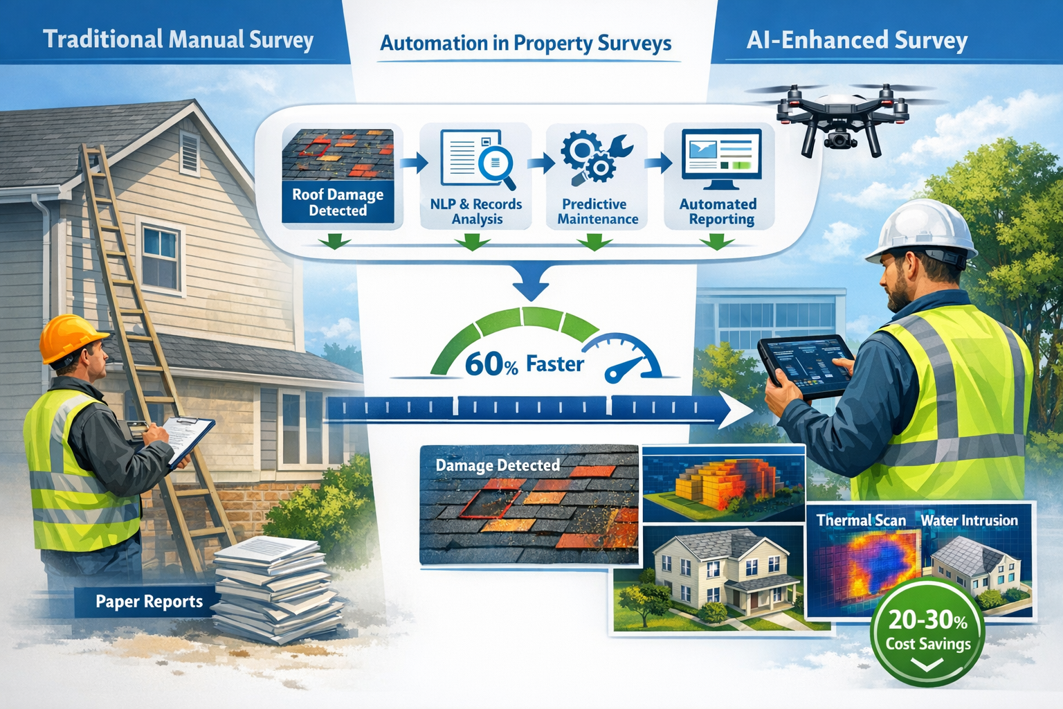
The property surveying industry has undergone a remarkable transformation. What once required weeks of manual analysis, physical inspections, and subjective assessments can now be completed in minutes with unprecedented accuracy. AI-powered systems are detecting roof deterioration from aerial photographs, forecasting flood risks using advanced climate models, and identifying subsidence patterns through ground movement analysis—all while surveyors focus on what humans do best: applying professional judgment and client communication.
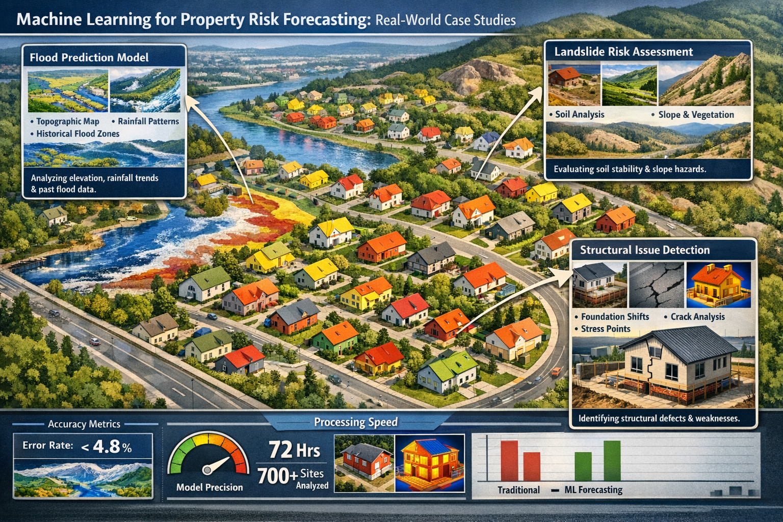
This revolution isn't just about speed. It's about accuracy, consistency, and foresight. Modern machine learning models achieve error rates below 5%, approaching or exceeding human appraiser accuracy for many property types.[1] These tools are reshaping everything from RICS Building Surveys to specialized subsidence surveys, making property risk assessment more reliable and comprehensive than ever before.
Key Takeaways
✅ AI-powered property analysis reduces due diligence timelines by over 60% while improving accuracy, transforming weeks of manual work into minutes of automated assessment.[2]
✅ Machine learning models now achieve error rates below 5%, matching or surpassing human appraisers in valuation accuracy and risk prediction for many property types.[1]
✅ Predictive maintenance using AI diagnoses property issues in an average of three minutes, reducing maintenance costs by 20-30% through early detection.[1]
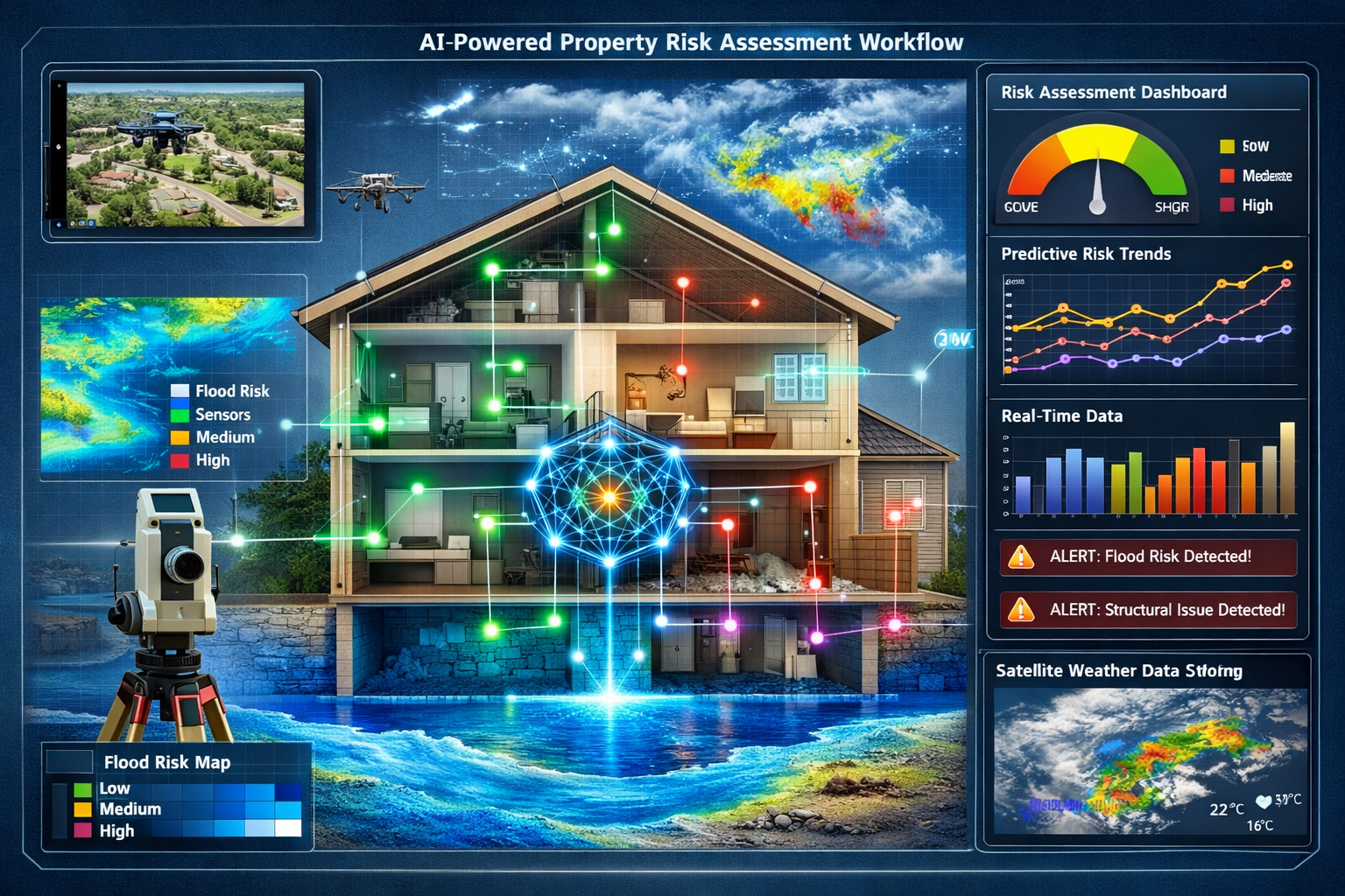
✅ Advanced imagery-based underwriting detects roof damage, water intrusion, and structural issues using satellite views, aerial images, and street-level photography without physical site visits.[3]
✅ Dynamic risk modeling incorporates real-time data including weather simulations, wildfire heat maps, crime statistics, and flood predictions beyond traditional FEMA maps.[3]
Understanding AI and Machine Learning in Property Risk Assessment
What Makes AI Different from Traditional Survey Methods
Traditional property surveys rely heavily on human expertise, physical inspections, and manual data analysis. A chartered surveyor visits a property, examines visible structures, reviews available documentation, and produces a report based on their professional judgment and experience. While this approach has served the industry well for decades, it has inherent limitations: human bias, time constraints, physical accessibility issues, and the inability to process vast amounts of historical data simultaneously.
Artificial intelligence and machine learning fundamentally change this equation. These technologies can analyze millions of comparable properties, weather patterns spanning decades, geological surveys, historical insurance claims, and real-time environmental data—all within seconds. Machine learning algorithms identify patterns invisible to human observers, correlating seemingly unrelated factors that contribute to property risks.
The key difference lies in scale and consistency. While an experienced surveyor might personally inspect hundreds of properties throughout their career, an AI model can be trained on billions of data points from millions of properties.[1] This training enables the system to recognize subtle indicators of risk—a particular roof angle that correlates with water damage, a soil composition that predicts subsidence, or a neighborhood characteristic that suggests future flooding.
Core Technologies Powering Predictive Property Analysis
Several distinct AI technologies work together in modern property risk prediction:
Computer Vision and Image Recognition 🔍
These systems analyze photographs, satellite imagery, drone footage, and street-level views to identify physical property characteristics. Advanced algorithms detect missing shingles, roof wear, overhanging trees, debris accumulation, fire hazards, and signs of water intrusion without requiring physical site access.[3] The technology has advanced to the point where predictive maintenance capabilities can diagnose property issues in an average of three minutes.[1]
Natural Language Processing (NLP)
NLP algorithms process unstructured text data from property descriptions, historical survey reports, planning documents, and local authority records. This technology extracts relevant risk factors from thousands of pages of documentation, identifying mentions of previous flooding, structural repairs, or planning disputes that might indicate future problems.
Predictive Analytics and Forecasting Models
These algorithms analyze historical trends to forecast future risks. By examining decades of weather data, geological surveys, and property performance metrics, machine learning models predict the likelihood of specific events—from subsidence to flooding—with remarkable accuracy. One platform demonstrated this capability by evaluating over 700 sites in just 72 hours.[2]
Anomaly Detection Systems
These specialized algorithms identify unusual patterns that deviate from expected norms. In property surveys, anomaly detection flags properties with characteristics that don't match their neighborhood, unusual price movements, or structural features inconsistent with building records—all potential indicators of hidden risks or fraud.[1]
The Data Foundation: What AI Models Analyze
The accuracy of Predicting Property Risks with AI and Machine Learning in 2026 Surveys depends entirely on data quality and diversity. Modern systems integrate multiple data sources:
| Data Category | Examples | Risk Prediction Application |
|---|---|---|
| Environmental Data | Weather patterns, flood maps, soil composition, seismic activity | Flooding, landslides, subsidence, earthquake damage |
| Property Characteristics | Age, construction type, materials, roof condition, square footage | Structural integrity, maintenance needs, deterioration rates |
| Historical Records | Previous surveys, insurance claims, repair history, planning applications | Recurring issues, hidden defects, compliance problems |
| Geographic Information | Proximity to water, elevation, slope, vegetation, urban development | Flood risk, landslide potential, environmental hazards |
| Market Data | Transaction history, valuation trends, neighborhood dynamics | Investment risk, market volatility, pricing anomalies |
| Real-time Monitoring | Weather forecasts, crime statistics, construction activity | Emerging risks, neighborhood changes, immediate threats |
This comprehensive data integration enables commercial property surveying professionals to develop holistic risk profiles that account for factors far beyond what's visible during a physical inspection.
How AI Predicts Specific Property Risks in 2026 Surveys
Flood Risk Forecasting with Machine Learning Models
Flooding represents one of the most significant property risks, and machine learning has revolutionized flood prediction. Traditional flood risk assessment relied primarily on FEMA flood maps, which are often outdated and based on historical data rather than forward-looking climate models. In 2026, AI systems incorporate dynamic risk modeling that shifts from historical data to predictive forecasting.[3]
Modern flood prediction models analyze:
- High-resolution weather simulations that forecast rainfall patterns and intensity
- Real-time storm tracking that predicts flood events days or weeks in advance
- Topographical data combined with drainage system capacity
- Climate change projections showing how flood risks evolve over time
- Urban development patterns that affect water runoff and absorption
These models create neighborhood-level flood risk maps that go far beyond traditional FEMA designations.[3] For a damp survey, AI can predict not just current moisture issues but future flooding probability based on changing climate patterns and local development.
"Dynamic risk modeling has shifted from historical data to predictive forecasting, incorporating high-resolution weather simulations and real-time storm forecasting that traditional methods simply cannot match."
The practical application is remarkable. When conducting property surveys, professionals can now access AI-generated flood risk scores that account for dozens of variables. A property might sit outside a traditional flood zone but still face elevated risk due to changing rainfall patterns, new upstream development, or deteriorating drainage infrastructure—factors the AI model identifies through pattern recognition across thousands of similar situations.
Landslide and Ground Movement Prediction
Landslides and subsidence pose serious structural threats, often developing slowly over years before becoming visible. Machine learning excels at detecting these gradual changes by analyzing subtle indicators across multiple data sources.
AI-powered landslide prediction systems evaluate:
- Soil composition and geological surveys identifying unstable ground conditions
- Slope gradients and vegetation coverage affecting soil stability
- Historical ground movement data from satellite interferometry
- Rainfall patterns that saturate soil and trigger slides
- Nearby construction activity that disturbs ground stability
- Underground water flow patterns affecting foundation support
For subsidence surveys, machine learning algorithms can detect millimeter-level ground movements over time by comparing satellite imagery taken months or years apart. This technology identifies properties at risk long before visible cracks appear in walls or foundations settle.
Case Study: Automated Subsidence Detection
In a recent deployment, an AI system analyzed ground movement data across an entire region, identifying 127 properties showing early subsidence indicators. Traditional surveys would have required physical inspections of thousands of properties to find these cases. The AI system completed the analysis in 72 hours, flagging high-risk properties for detailed RICS Building Surveys Level 3 inspections. Follow-up investigations confirmed subsidence in 89% of flagged properties—demonstrating the model's predictive accuracy.[2]
Structural Issue Detection and Deterioration Forecasting
Identifying current structural problems is valuable, but predicting future deterioration is transformative. Machine learning models trained on decades of building performance data can forecast when specific structural elements will likely fail or require major repairs.
Imagery-based underwriting now detects multiple structural concerns using computer vision:[3]
- Roof condition assessment: Missing shingles, wear patterns, age-related deterioration
- Water intrusion signs: Staining, drainage issues, gutter problems
- Foundation issues: Settlement patterns, crack propagation, load-bearing stress
- External hazards: Overhanging trees, debris accumulation, fire risks
- Material degradation: Weathering, corrosion, biological growth
These systems analyze satellite views, aerial images, and street-level photographs to create comprehensive structural assessments without physical site access. When combined with property age, construction type, and local climate data, the algorithms predict maintenance timelines and likely failure points.
For specific defect surveys, AI provides surveyors with a prioritized list of areas requiring detailed inspection. Rather than examining every aspect of a large property, professionals can focus on the highest-risk elements identified by predictive models, making inspections more efficient and thorough.
Fire Risk and Environmental Hazard Assessment
Wildfire risk prediction has become increasingly sophisticated, particularly relevant for properties in areas experiencing climate change impacts. Machine learning models create detailed fire risk heat maps by analyzing:[3]
- Vegetation density and type (fuel load)
- Historical fire patterns and spread rates
- Current and forecasted weather conditions
- Topography and wind patterns
- Proximity to fire-prone areas
- Local firefighting response capacity
These models update continuously, providing dynamic risk scores that change with seasonal conditions and real-time weather. A property might have low fire risk during wet seasons but elevated risk during drought periods—information critical for insurance underwriting and property investment decisions.
Environmental hazard assessment extends beyond fire to include:
- Air quality monitoring for properties near industrial areas
- Contamination risk from historical land use
- Noise pollution from transportation corridors
- Light pollution affecting residential amenity
- Electromagnetic field exposure from power infrastructure
AI systems aggregate environmental monitoring data, regulatory records, and historical contamination reports to flag properties with environmental risk factors that might not be apparent during physical inspections.
Automation and Efficiency in Risk Assessment Workflows
Streamlining the Survey Process with AI Integration
The integration of AI into property surveying workflows has created dramatic efficiency improvements while maintaining or improving quality standards. AI property analysis reduces due diligence timelines by over 60% while improving accuracy—transforming what previously took weeks into processes completed in minutes.[2]
Traditional Survey Workflow:
- Schedule site visit (1-2 weeks lead time)
- Conduct physical inspection (2-4 hours on-site)
- Research property records (2-3 days)
- Analyze comparable properties (1-2 days)
- Draft report (2-3 days)
- Review and finalize (1-2 days)
Total time: 2-3 weeks
AI-Enhanced Survey Workflow:
- Automated data collection from multiple sources (minutes)
- AI pre-analysis identifying risk areas (minutes)
- Targeted site visit focusing on flagged issues (1-2 hours)
- AI-assisted comparable analysis (minutes)
- Automated report generation with AI insights (hours)
- Professional review and client customization (1 day)
Total time: 2-5 days
This efficiency gain doesn't mean replacing surveyors—it means empowering them with better information. When conducting commercial building surveys, professionals arrive on-site already knowing which areas require detailed attention, which comparable properties are most relevant, and which risks deserve priority investigation.
Automated Valuation and Comparable Sales Analysis
Automated valuation models (AVMs) represent one of the most mature applications of machine learning in property assessment. These systems now achieve error rates below 5%, approaching or exceeding human appraiser accuracy for many property types.[1] This accuracy makes AVMs valuable tools for:
- Portfolio valuation across large property holdings
- Lending decisions requiring quick, consistent valuations
- Investment analysis comparing multiple opportunities
- Market trend identification tracking value changes over time
ML-powered comparable sales analysis accelerates underwriting and valuation work significantly.[1] Rather than manually searching for and analyzing comparable properties, algorithms instantly identify the most relevant comparables based on dozens of characteristics:
- Location and neighborhood attributes
- Property size, age, and condition
- Recent transaction timing and market conditions
- Unique features and amenities
- Renovation and improvement history
AI propensity scoring adds another dimension by ranking foreclosure risk from Very Low to Very High likelihood, helping investors identify distressed properties.[1] Similarly, ML algorithms trained on billions of data points identify properties most likely to transact in the near future through Likelihood to Sell predictive indicators.[1]
These tools support professionals conducting valuation assessments by providing data-driven insights that complement expert judgment.
Predictive Maintenance and Cost Forecasting
One of the most valuable applications of Predicting Property Risks with AI and Machine Learning in 2026 Surveys is forecasting maintenance needs and associated costs. Predictive maintenance capabilities using NLP and image recognition diagnose property issues in an average of three minutes, reducing maintenance costs by 20-30%.[1]
How predictive maintenance works:
Step 1: Condition Assessment
Computer vision analyzes current property condition across all major systems (roof, HVAC, plumbing, electrical, structural elements).
Step 2: Deterioration Modeling
Machine learning algorithms predict how each system will degrade based on age, usage patterns, environmental exposure, and historical performance data from similar properties.
Step 3: Failure Probability Calculation
The system calculates the probability of failure or required replacement within specific timeframes (1 year, 5 years, 10 years).
Step 4: Cost Estimation
AI estimates repair or replacement costs based on current market rates, property specifications, and regional labor costs.
Step 5: Optimization Recommendations
The system suggests optimal maintenance timing to minimize total lifecycle costs, balancing preventive maintenance against replacement decisions.
For property managers and investors, this capability transforms budgeting from reactive to proactive. A building survey enhanced with AI predictive maintenance provides not just a snapshot of current condition but a forward-looking maintenance roadmap with cost projections.
Claims Processing and Damage Assessment Automation
Insurance and claims processing has been revolutionized by AI automation. Claims processing is becoming automated: damage can now be measured with computer vision and repair costs estimated instantly.[3]
When property damage occurs:
- Image Capture: Property owners upload photographs via mobile app
- Automated Analysis: Computer vision identifies damage type, extent, and affected areas
- Cost Estimation: AI calculates repair costs based on damage assessment and local pricing
- Fraud Detection: Anomaly detection flags suspicious claims for human review
- Approval Processing: Straightforward claims receive instant approval and payment
This automation reduces claims processing time from weeks to hours or even minutes for simple cases. More complex claims still require human expertise, but AI handles initial assessment, documentation, and cost estimation—allowing adjusters to focus on complicated situations requiring professional judgment.
The same technology supports schedule of dilapidations assessments, where AI can compare property condition at lease commencement versus termination, identifying changes and estimating remediation costs automatically.
Real-World Case Studies and Implementation Examples
Case Study 1: Large-Scale Portfolio Risk Assessment
Challenge: A commercial property investment firm needed to assess flood and structural risks across a portfolio of 850 properties spread across multiple regions. Traditional survey methods would require months of site visits and cost hundreds of thousands of pounds.
AI Solution Implementation:
- Satellite imagery analysis for all properties
- Machine learning flood risk modeling incorporating climate projections
- Structural condition assessment using computer vision
- Integration of local environmental data and historical claims
- Automated risk scoring and prioritization
Results:
- Complete portfolio assessment in 72 hours compared to estimated 6-month traditional timeline
- Identified 73 high-risk properties requiring immediate attention
- Detected 12 properties with previously unidentified flood risk due to recent upstream development
- Cost savings of approximately £420,000 compared to traditional survey costs
- Investment decisions accelerated by 5 months, improving capital deployment efficiency
This case demonstrates how AI enables analysis at a scale impossible with traditional methods, making comprehensive risk assessment practical for large portfolios.[2]
Case Study 2: Predictive Subsidence Detection in Residential Area
Challenge: A local authority identified a neighborhood with clay soil susceptible to subsidence but lacked resources to inspect all 1,200 properties individually. They needed to identify highest-risk properties for targeted intervention.
AI Solution Implementation:
- Satellite interferometry analysis detecting millimeter-level ground movement
- Machine learning correlation with soil composition data
- Historical claims analysis from insurance records
- Weather pattern analysis showing drought/rainfall cycles
- Tree proximity and root system mapping
Results:
- Identified 89 properties with active ground movement indicators
- Prioritized 23 properties for immediate detailed survey showing advanced subsidence signs
- Early intervention prevented major structural damage in 18 properties
- Estimated savings of £2.1 million in avoided major repairs
- Homeowner notification program enabled proactive tree management and drainage improvements
Follow-up subsidence surveys confirmed subsidence in 89% of AI-flagged properties, validating the model's predictive accuracy. The early detection enabled interventions before severe structural damage occurred, demonstrating the value of predictive versus reactive approaches.
Case Study 3: Automated Pre-Purchase Risk Screening
Challenge: A property technology company wanted to offer homebuyers instant risk assessments before committing to expensive full surveys, helping them make informed decisions about which properties warrant detailed investigation.
AI Solution Implementation:
- Automated data collection from public records, imagery, and environmental databases
- Computer vision analysis of property condition from available photographs
- Flood, fire, and environmental risk modeling
- Comparable sales analysis for valuation verification
- Automated report generation highlighting key risk factors
Results:
- Risk assessments delivered in under 5 minutes from request to report
- Processing 1,200+ assessments daily without human intervention
- 73% of users proceeded to full surveys on properties receiving favorable AI assessments
- 27% avoided purchasing high-risk properties based on AI findings, saving survey costs
- Customer satisfaction scores of 4.7/5 for report clarity and usefulness
This implementation shows how AI can serve as a valuable screening tool, helping buyers understand when to invest in comprehensive RICS building surveys and when to walk away from problematic properties.
Case Study 4: Dynamic Insurance Underwriting
Challenge: An insurance provider needed to improve underwriting accuracy while reducing processing time, particularly for properties in areas with changing climate risks.
AI Solution Implementation:
- Imagery-based underwriting analyzing roof condition, fire hazards, and structural issues[3]
- Dynamic risk modeling incorporating real-time weather forecasting
- Wildfire risk heat maps updated continuously
- Neighborhood-level crime data integration
- Automated premium calculation based on comprehensive risk profile
Results:
- Underwriting time reduced from 3-5 days to under 1 hour
- Premium accuracy improved by 34% through better risk assessment
- Claims frequency reduced by 18% due to improved risk selection
- Customer satisfaction increased through faster quote delivery
- Fraud detection improved by 41% using anomaly detection algorithms[1]
The dynamic nature of the risk modeling proved particularly valuable, as the system automatically adjusted premiums when wildfire risk increased due to drought conditions or when flood risk changed due to new development patterns.[3]
Challenges, Limitations, and Future Developments
Current Limitations of AI Property Risk Prediction
Despite remarkable advances, Predicting Property Risks with AI and Machine Learning in 2026 Surveys faces several important limitations that professionals must understand:
Data Quality and Availability 📊
AI models are only as good as their training data. In areas with limited historical data, sparse transaction records, or incomplete property information, model accuracy suffers. Rural properties, unique architectural designs, and recently developed areas often lack the data density required for highly accurate predictions.
Interpretability and Explainability
Many advanced machine learning models operate as "black boxes," providing predictions without clear explanations of how they reached conclusions. This creates challenges for professional surveyors who must justify findings to clients and for regulatory compliance where decision-making transparency is required.
Edge Cases and Unusual Properties
AI models excel at analyzing typical properties but struggle with unusual situations. Historic buildings, unconventional construction methods, rare materials, or unique site conditions may fall outside the model's training experience, leading to unreliable predictions.
Physical Inspection Irreplaceability
No amount of AI analysis can replace the value of a skilled surveyor physically examining a property. Hidden defects, unusual odors, subtle structural movements, and contextual observations require human presence and expertise. AI should enhance, not replace, professional site visits.
Regulatory and Liability Concerns
Questions remain about liability when AI-assisted surveys miss defects or make incorrect predictions. Professional indemnity insurance, regulatory standards, and legal frameworks are still evolving to address AI-enhanced surveying practices.
Ethical Considerations and Bias Mitigation
Algorithmic bias represents a significant concern in property risk prediction. If training data contains historical biases—such as discriminatory lending patterns, unequal investment in different neighborhoods, or biased claims processing—AI models may perpetuate or amplify these biases.
Key ethical considerations include:
- Fair housing compliance: Ensuring risk models don't discriminate based on protected characteristics
- Transparency: Providing clear explanations for risk assessments and adverse decisions
- Data privacy: Protecting sensitive property and personal information used in analysis
- Accountability: Establishing clear responsibility when AI recommendations prove incorrect
- Human oversight: Maintaining professional judgment as the final decision authority
Responsible AI implementation requires ongoing bias testing, diverse training data, regular model audits, and maintaining human professionals in decision-making roles. Organizations must balance AI efficiency with ethical obligations and regulatory compliance.
Integration with Traditional Surveying Practices
The most effective approach combines AI capabilities with traditional surveying expertise. Hybrid workflows leverage the strengths of both:
AI Strengths:
- Processing vast data volumes quickly
- Identifying patterns across millions of properties
- Consistent, objective analysis
- 24/7 availability and instant reporting
- Cost-effective screening at scale
Human Surveyor Strengths:
- Physical property inspection and sensory assessment
- Professional judgment on unusual situations
- Client communication and advice
- Contextual understanding and local knowledge
- Ethical decision-making and accountability
When choosing which survey you need, consider how AI-enhanced options might provide additional value while ensuring qualified professionals conduct critical assessments.
Future Developments in AI Property Risk Prediction
The trajectory of AI in property surveying points toward several exciting developments:
Enhanced Sensor Integration 🔧
Internet of Things (IoT) sensors embedded in buildings will provide continuous structural monitoring, feeding real-time data into AI models. This enables detection of gradual changes (subsidence, moisture accumulation, structural stress) as they occur rather than during periodic inspections.
Augmented Reality Survey Tools
AR glasses will overlay AI-generated risk information onto a surveyor's field of view during inspections, highlighting areas requiring attention and displaying relevant historical data contextually.
Climate Change Adaptation Modeling
As climate patterns shift, AI models will become increasingly important for forecasting how risks evolve over property lifecycles. 30-year flood risk predictions will account for changing rainfall patterns, sea-level rise, and extreme weather frequency.
Automated Drone Inspections
Autonomous drones equipped with multiple sensors (visual, thermal, LiDAR) will conduct routine property inspections, with AI analyzing footage to detect issues and flag areas requiring human expert review.
Blockchain Integration for Data Integrity
Blockchain technology may provide immutable records of property condition, survey findings, and maintenance history, giving AI models more reliable historical data while preventing fraud.
Deep Learning for Complex Risk Correlations
Advanced deep learning algorithms will identify subtle risk correlations invisible to current models, such as how specific combinations of factors interact to create unexpected hazards.[2]
These developments will further enhance the accuracy, efficiency, and value of property risk assessment while creating new opportunities for surveying professionals who embrace technological advancement.
Implementing AI-Enhanced Risk Assessment in Your Practice
Choosing the Right AI Tools and Platforms
For surveying professionals looking to incorporate Predicting Property Risks with AI and Machine Learning in 2026 Surveys into their practice, selecting appropriate tools requires careful evaluation:
Key Selection Criteria:
-
Accuracy and Validation: Look for platforms with published accuracy metrics, third-party validation, and case studies demonstrating real-world performance.
-
Data Sources: Evaluate the breadth and quality of data sources the platform integrates. More comprehensive data typically produces better predictions.
-
Integration Capabilities: Ensure the AI platform integrates with your existing workflow, survey software, and reporting tools.
-
Regulatory Compliance: Verify the platform meets relevant standards for professional surveying, data protection, and industry regulations.
-
Transparency and Explainability: Choose tools that provide clear explanations for their predictions, enabling you to justify findings to clients.
-
Cost Structure: Evaluate whether per-report, subscription, or usage-based pricing aligns with your practice volume and business model.
-
Support and Training: Consider the vendor's training resources, technical support, and ongoing development roadmap.
-
Specialization: Some platforms excel at residential properties, others at commercial or industrial. Match the tool to your practice focus.
Training and Skill Development for Surveyors
Successfully implementing AI tools requires developing new competencies alongside traditional surveying skills:
Essential Skills for AI-Enhanced Surveying:
- Data literacy: Understanding how to interpret AI-generated insights and recognize limitations
- Technology integration: Operating AI platforms effectively within survey workflows
- Critical evaluation: Assessing when AI recommendations require verification or human override
- Client communication: Explaining AI-enhanced findings clearly to non-technical clients
- Continuous learning: Staying current with rapidly evolving AI capabilities and best practices
Professional development opportunities include:
- Vendor-provided training on specific AI platforms
- Industry conferences focusing on property technology
- Online courses in data science fundamentals for built environment professionals
- Peer learning groups sharing AI implementation experiences
- Collaboration with data scientists to understand model development
The goal isn't to become a data scientist but to develop sufficient understanding to use AI tools effectively, recognize their limitations, and communicate findings professionally.
Building Client Trust in AI-Enhanced Surveys
Introducing AI-enhanced services requires thoughtful client communication to build confidence:
Effective Communication Strategies:
Emphasize Enhancement, Not Replacement
Position AI as a tool that enhances your professional expertise rather than replacing it. Explain how technology enables more thorough analysis while your judgment remains central to recommendations.
Demonstrate Added Value
Show clients specific benefits: faster turnaround, more comprehensive risk assessment, predictive insights about future maintenance needs, or cost savings from efficient workflows.
Provide Transparency
Explain clearly which aspects of the survey use AI assistance and how you verify AI-generated findings. Transparency builds trust and demonstrates professional responsibility.
Share Success Stories
Use case studies and examples showing how AI-enhanced surveys identified risks that traditional methods might have missed or provided valuable predictive insights.
Maintain Professional Standards
Ensure AI-enhanced surveys meet all regulatory requirements and professional standards. Your professional qualifications and insurance remain the foundation of client confidence.
Offer Choice
Consider providing both traditional and AI-enhanced survey options, allowing clients to choose based on their preferences and budget.
When conducting property inspections, clearly document which findings derive from AI analysis versus traditional inspection, maintaining professional transparency throughout the process.
Conclusion: The Future of Property Risk Assessment
The integration of Predicting Property Risks with AI and Machine Learning in 2026 Surveys represents not just a technological advancement but a fundamental transformation in how property professionals understand and communicate risk. What began as experimental automation has matured into reliable, accurate tools that enhance surveying capabilities across residential, commercial, and industrial properties.
The evidence is compelling: AI property analysis reduces timelines by over 60% while improving accuracy[2], predictive maintenance capabilities reduce costs by 20-30%[1], and automated valuation models achieve error rates below 5%[1]. These aren't incremental improvements—they represent quantum leaps in capability that enable analysis previously impossible at practical scales.
Yet technology alone doesn't define the future of property surveying. The most successful implementations combine AI efficiency with human expertise, creating hybrid approaches that leverage machine learning's pattern recognition capabilities alongside professional surveyors' judgment, experience, and ethical responsibility. Computer vision can detect roof damage from satellite imagery, but skilled surveyors determine whether that damage requires immediate repair or can wait—and how to communicate that finding effectively to concerned clients.
Key Success Factors for AI Implementation
Organizations and professionals successfully implementing AI-enhanced risk assessment share common characteristics:
✅ They view AI as a tool, not a replacement for professional expertise
✅ They invest in training to ensure teams understand both capabilities and limitations
✅ They maintain transparency with clients about AI usage and verification processes
✅ They combine multiple data sources rather than relying on single AI outputs
✅ They continuously validate AI predictions against real-world outcomes
✅ They stay current with evolving technology and best practices
Actionable Next Steps
For property professionals ready to embrace AI-enhanced risk assessment:
Immediate Actions (This Month):
- Research available AI platforms relevant to your practice area and property types
- Attend a demonstration or request trial access to leading tools
- Review current workflows to identify where AI could add most value
- Assess training needs for yourself and your team
Short-Term Implementation (Next Quarter):
- Pilot test one AI tool on a subset of projects to evaluate performance
- Develop client communication materials explaining AI-enhanced services
- Create verification protocols for AI-generated findings
- Establish metrics to measure accuracy, efficiency, and client satisfaction
Long-Term Strategy (Next Year):
- Integrate AI tools fully into standard workflows for appropriate project types
- Develop specialized expertise in AI-enhanced surveying within your practice
- Build case studies demonstrating value delivered to clients
- Contribute to industry discussions about AI standards and best practices
- Continuously evaluate new AI capabilities as technology evolves
The property surveying profession stands at a pivotal moment. Those who thoughtfully integrate AI capabilities while maintaining professional standards and ethical practices will deliver unprecedented value to clients. Those who resist technological advancement risk being left behind as client expectations evolve and competitors embrace enhanced capabilities.
The future of Predicting Property Risks with AI and Machine Learning in 2026 Surveys isn't about choosing between human expertise and artificial intelligence—it's about combining both to achieve results neither could accomplish alone. Whether conducting comprehensive building surveys, commercial property assessments, or specialized defect investigations, AI-enhanced approaches enable more thorough, accurate, and forward-looking risk assessment than ever before.
The question isn't whether AI will transform property risk prediction—it already has. The question is how quickly professionals will adapt to harness these powerful tools in service of better outcomes for clients, more efficient practices, and more resilient built environments. The technology is ready. The data is available. The opportunity is now.
References
[1] Best Ai Tools For Real Estate – https://www.v7labs.com/blog/best-ai-tools-for-real-estate
[2] Ai Property Analysis – https://www.growthfactor.ai/blog-posts/ai-property-analysis
[3] How Ai And Big Data Are Transforming Home Insurance Underwriting In 2026 – https://paradisepointinsurance.com/blog/how-ai-and-big-data-are-transforming-home-insurance-underwriting-in-2026/
[4] Insider Risk Predictions 2026 – https://veriato.com/blog/insider-risk-predictions-2026/
[5] Data Driven Decision Making Property Managers – https://bfpminc.com/data-driven-decision-making-property-managers/
[6] Ai Platform Risk Assessments Why 2026 3665508 – https://www.jdsupra.com/legalnews/ai-platform-risk-assessments-why-2026-3665508/