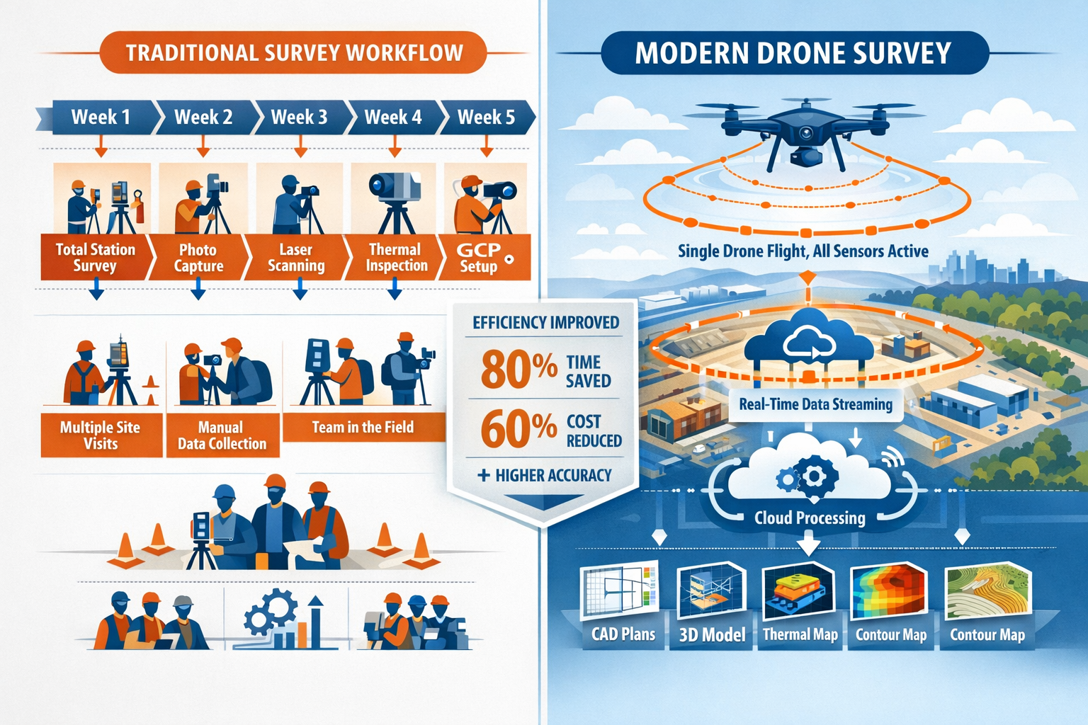
The surveying industry has undergone a remarkable transformation. What once required multiple site visits, different equipment setups, and weeks of data processing can now be accomplished in a single autonomous drone flight. Multi-Sensor Drone Systems in Modern Surveying: LiDAR, Photogrammetry, and Beyond represent the cutting edge of geospatial data collection, combining synchronized sensor arrays that capture comprehensive property information with unprecedented efficiency and accuracy.
In 2026, the integration of LiDAR scanners, photogrammetry cameras, multispectral sensors, and thermal imaging units on a single unmanned aerial vehicle (UAV) platform has become the industry standard. These advanced systems deliver centimeter-level accuracy while dramatically reducing field time, costs, and the need for ground control points. For surveyors, property professionals, and construction managers, understanding these multi-sensor capabilities is essential for staying competitive in an increasingly data-driven marketplace.
Key Takeaways
- 🚁 Synchronized sensor arrays on modern drones capture LiDAR, photogrammetry, thermal, and multispectral data simultaneously in one flight, eliminating the need for multiple site visits
- 📍 RTK/PPK GNSS systems now deliver centimeter-level positioning accuracy, meeting professional survey-grade standards without extensive ground control point networks
- 🤖 AI-powered processing platforms automate feature extraction, change detection, and defect identification—tasks that previously required days or weeks of manual analysis
- ⚡ Autonomous flight planning with real-time obstacle avoidance enables hundreds of acres to be surveyed in hours, with CAD-ready deliverables generated through cloud processing
- 🌲 Enhanced LiDAR performance with improved pulse repetition rates and IMU integration now penetrates dense forest canopies and challenging environments previously difficult to survey
Understanding Multi-Sensor Drone Systems in Modern Surveying
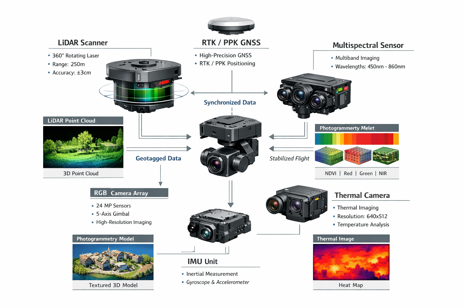
Multi-sensor drone systems represent a fundamental shift in how geospatial data is collected and processed. Unlike traditional surveying methods that require separate equipment and visits for different data types, modern UAV platforms integrate multiple sensors that work together seamlessly.[1]
The Evolution of Drone-Based Surveying Technology
The surveying profession has always relied on precision instruments, from theodolites to total stations. However, the introduction of drone technology brought unprecedented efficiency gains. Early commercial drones for surveying carried single cameras and required extensive ground control point networks to achieve acceptable accuracy.
By 2026, the landscape has changed dramatically. Modern multi-sensor systems combine:
- LiDAR scanners for precise three-dimensional point cloud data
- High-resolution RGB cameras for photogrammetric reconstruction
- Multispectral sensors for vegetation analysis and material identification
- Thermal imaging cameras for heat signature detection and building diagnostics
- RTK/PPK GNSS receivers for centimeter-level positioning accuracy
These sensors operate simultaneously during flight, with synchronized data capture ensuring that all measurements are perfectly aligned in time and space.[2] This integration enables what professionals call "single-pass data collection"—gathering comprehensive information about a property or site in one efficient operation.
How Synchronized Sensor Arrays Work
The key to multi-sensor drone effectiveness lies in precise synchronization. Each sensor captures data at specific intervals, and advanced onboard computers ensure that LiDAR points, camera exposures, and other measurements are time-stamped and georeferenced with extreme accuracy.
Modern systems use sophisticated Inertial Measurement Units (IMUs) that track the drone's position, orientation, and movement hundreds of times per second. This information allows processing software to correct for drone motion and ensure that data from different sensors aligns perfectly.[2]
The result is a comprehensive dataset that includes:
| Data Type | Source Sensor | Primary Applications |
|---|---|---|
| 3D Point Clouds | LiDAR Scanner | Topographic mapping, volumetric calculations, vegetation penetration |
| Orthomosaic Images | RGB Cameras | Visual documentation, photogrammetric modeling, feature identification |
| Thermal Maps | Thermal Camera | Building diagnostics, heat loss detection, moisture identification |
| Vegetation Indices | Multispectral Sensor | Agricultural analysis, environmental monitoring, land classification |
| Precise Coordinates | RTK/PPK GNSS | Survey-grade positioning, boundary determination, control network |
For professionals conducting drone surveys, this multi-sensor approach means capturing far more information per flight while maintaining the accuracy standards required for professional work.
LiDAR Technology: The Foundation of Modern Aerial Surveying
Light Detection and Ranging (LiDAR) has become the cornerstone technology for aerial surveying applications. LiDAR-enabled UAVs have achieved mainstream status as the go-to method for topographic surveys, forestry assessments, utility corridor mapping, and mining exploration.[2]
How LiDAR Systems Operate on Drones
LiDAR works by emitting rapid laser pulses—often hundreds of thousands per second—and measuring the time it takes for each pulse to bounce back from surfaces below. Modern drone-mounted LiDAR systems feature dramatically improved Pulse Repetition Rates (PRR), enabling denser point clouds and more detailed terrain models than earlier generations.[2]
The technology excels at several critical surveying tasks:
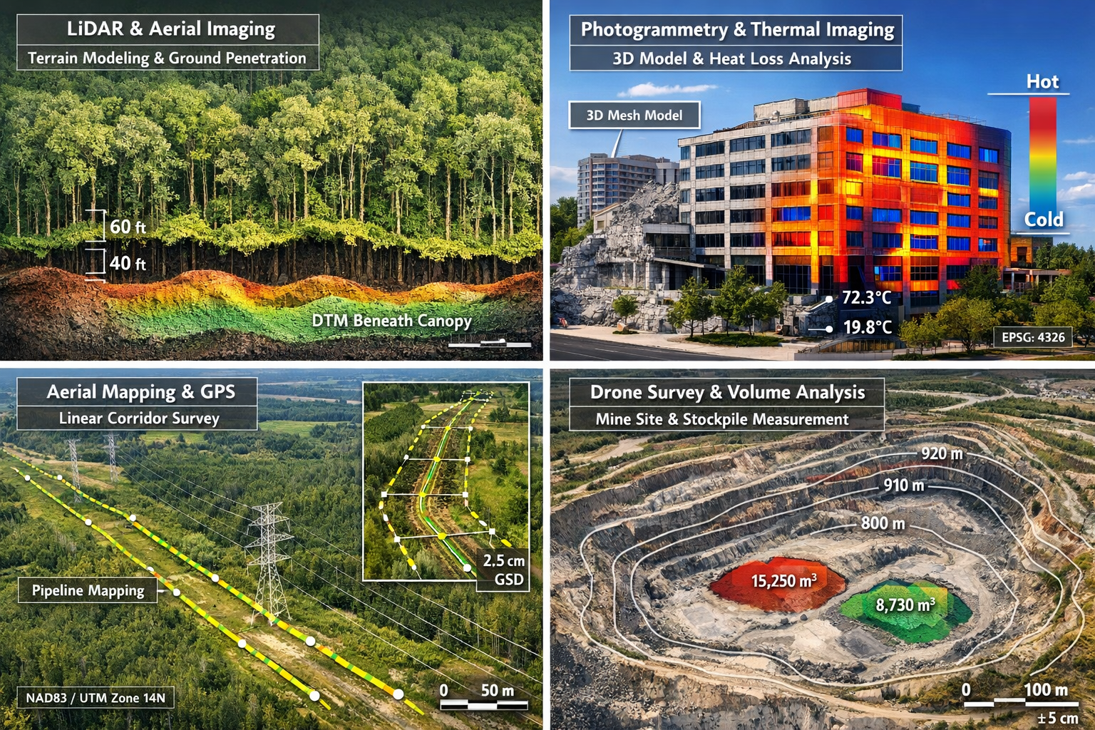
- Terrain modeling through dense vegetation where traditional photogrammetry fails
- Accurate elevation data for flood modeling and drainage design
- Volumetric calculations for stockpiles, excavations, and earthwork projects
- Infrastructure inspection of powerlines, bridges, and linear assets
- Forest inventory with individual tree detection and canopy analysis
LiDAR Performance Improvements in 2026
Current LiDAR systems have addressed previous limitations through technological advances:
Enhanced canopy penetration: Improved algorithms now classify multiple returns from a single laser pulse, allowing surveyors to distinguish between vegetation layers and accurately model the ground surface beneath dense forest cover.[2]
Faster data acquisition: Higher pulse repetition rates mean more points per second, enabling faster flight speeds without sacrificing point density. This translates directly to larger survey areas covered per battery charge or flight hour.
Better integration with IMUs: More accurate inertial measurement systems reduce positioning errors and improve the quality of point clouds, especially during turns and altitude changes.[2]
Reduced size and weight: Miniaturization has made survey-grade LiDAR accessible on smaller, more affordable drone platforms, democratizing access to this technology for smaller surveying firms.
LiDAR Applications Across Property Types
Different property types benefit from LiDAR's unique capabilities:
Commercial and industrial sites: LiDAR provides accurate as-built documentation of complex facilities, including rooftop equipment, loading docks, and site drainage patterns. When combined with commercial building surveys, LiDAR data offers comprehensive property documentation.
Residential developments: For large-scale housing projects, LiDAR quickly generates accurate topographic surveys for site planning, grading design, and drainage engineering.
Agricultural land: LiDAR-derived elevation models help farmers optimize irrigation systems, identify erosion-prone areas, and plan field drainage improvements.
Infrastructure corridors: Railways, highways, pipelines, and powerline routes benefit from LiDAR's ability to rapidly survey linear assets stretching for miles, detecting encroachments and vegetation management needs.
Photogrammetry: Visual Intelligence and 3D Modeling
While LiDAR excels at precise elevation measurement, photogrammetry provides rich visual context and detailed texture information. Modern multi-sensor systems combine both technologies to deliver comprehensive property documentation.[4]
The Science Behind Aerial Photogrammetry
Photogrammetry creates three-dimensional models and measurements from overlapping two-dimensional photographs. Advanced software analyzes thousands of images, identifying common features and using parallax (the apparent shift in object position when viewed from different angles) to calculate precise three-dimensional coordinates.
Modern drone photogrammetry workflows produce several valuable deliverables:
- Orthomosaic images: Geometrically corrected aerial photographs with uniform scale, suitable for accurate measurement
- 3D textured models: Realistic three-dimensional representations of buildings, terrain, and infrastructure
- Digital Surface Models (DSM): Elevation data including buildings, vegetation, and other surface features
- Contour maps: Traditional surveying products generated automatically from photogrammetric data
High-Resolution Cameras and Image Processing
The cameras used in professional surveying drones have evolved significantly. Current systems feature:
Large sensors: Full-frame and medium-format sensors capture more light and detail, enabling surveys from higher altitudes while maintaining ground resolution.
Mechanical shutters: These eliminate motion blur during image capture, critical for maintaining accuracy in photogrammetric processing.
Multiple camera arrays: Some advanced systems use several cameras simultaneously, capturing imagery from different angles to improve 3D reconstruction quality.[1]
Integrated RTK positioning: Camera positions are recorded with centimeter-level accuracy during each exposure, dramatically reducing the need for ground control points.[2]
Photogrammetry vs. LiDAR: Complementary Technologies
Rather than competing technologies, photogrammetry and LiDAR complement each other perfectly:
Photogrammetry advantages:
- ✅ Rich visual documentation with true color
- ✅ Detailed texture for 3D models
- ✅ Lower equipment costs
- ✅ Easier data interpretation for non-technical stakeholders
LiDAR advantages:
- ✅ Penetrates vegetation to reach ground surface
- ✅ Works in low-light conditions
- ✅ More accurate in vertical measurement
- ✅ Better for complex structures with overhangs
Multi-sensor systems capture both simultaneously, allowing surveyors to leverage the strengths of each technology. For example, a RICS building survey might use photogrammetry for detailed facade documentation while employing LiDAR for precise roof measurements and site topography.
Beyond LiDAR and Photogrammetry: Additional Sensor Technologies
The "beyond" in Multi-Sensor Drone Systems in Modern Surveying: LiDAR, Photogrammetry, and Beyond refers to the expanding array of specialized sensors that provide unique insights into property conditions and characteristics.[5]
Thermal Imaging for Building Diagnostics
Thermal cameras detect infrared radiation, revealing temperature differences invisible to the human eye. In surveying and property inspection applications, thermal imaging identifies:
- Heat loss through building envelopes, indicating insulation deficiencies
- Moisture intrusion that appears as cooler areas due to evaporative cooling
- Electrical issues in solar panels, transformers, and distribution equipment
- HVAC performance and ductwork leakage in commercial buildings
- Roof membrane damage where trapped moisture creates thermal signatures
Modern thermal sensors integrate seamlessly with RGB cameras, allowing inspectors to correlate thermal anomalies with specific building features. This capability is particularly valuable for specific defect surveys where thermal imaging can identify hidden issues not visible during traditional inspections.
Multispectral and Hyperspectral Imaging
Multispectral sensors capture light in specific wavelength bands beyond visible light, including near-infrared and red-edge portions of the spectrum. These sensors enable:
- Vegetation health analysis through NDVI (Normalized Difference Vegetation Index) calculations
- Crop stress detection before visible symptoms appear
- Material identification based on spectral signatures
- Environmental monitoring of wetlands, forests, and conservation areas
- Archaeological surveys revealing buried features through vegetation patterns
Agricultural applications have driven multispectral sensor development, but these technologies increasingly serve broader surveying needs, including environmental impact assessments and land use classification.
Ground Penetrating Radar (GPR) Integration
Emerging drone platforms now carry miniaturized GPR systems that detect subsurface features without excavation. Applications include:
- Utility location and mapping
- Archaeological investigation
- Pavement condition assessment
- Soil composition analysis
- Underground storage tank detection
While still specialized, GPR-equipped drones represent the expanding frontier of multi-sensor surveying capabilities.
Gas Detection and Environmental Sensors
Environmental monitoring drones carry sensors that detect:
- Methane and other gases for pipeline inspection and landfill monitoring
- Air quality parameters including particulates and pollutants
- Radiation levels for nuclear facility monitoring
- Chemical signatures for industrial site assessment
These specialized sensors expand surveying beyond physical measurement into environmental characterization and safety monitoring.
Achieving Survey-Grade Accuracy: RTK and PPK Systems
Accuracy distinguishes professional surveying from casual aerial photography. Modern multi-sensor drones achieve centimeter-level positioning accuracy through advanced GNSS (Global Navigation Satellite System) technologies.[2][3]
Understanding RTK and PPK Positioning
Real-Time Kinematic (RTK) positioning uses a ground-based reference station with a known precise location. This base station communicates with the drone during flight, providing correction data that eliminates most GNSS errors. The result is positioning accuracy of 1-2 centimeters horizontally and 2-3 centimeters vertically.[2]
Post-Processed Kinematic (PPK) achieves similar accuracy but applies corrections after the flight. The drone logs raw GNSS data during the mission, which is later processed against base station data or virtual reference station networks. PPK offers advantages when radio communication is unreliable or when surveying large areas beyond RTK radio range.[3]
Reducing Ground Control Point Requirements
Traditional aerial surveying required extensive networks of ground control points (GCPs)—surveyed markers visible in aerial imagery that provide known coordinates for georeferencing. Establishing GCPs is time-consuming and sometimes impossible in inaccessible terrain.
RTK/PPK technology has dramatically reduced GCP requirements. Modern workflows achieve survey-grade accuracy with:
- Minimal GCPs: Perhaps 3-5 checkpoints for quality verification rather than dozens for georeferencing
- No GCPs in some applications: RTK-equipped drones can produce accurate results without any ground control in appropriate circumstances
- Remote area advantages: Particularly beneficial for linear infrastructure projects and remote locations where GCP establishment is costly[2]
This reduction in ground control requirements translates directly to faster mobilization, lower field costs, and the ability to survey areas that were previously impractical to access.
Survey-Grade Deliverables from Drone Data
With RTK/PPK positioning, multi-sensor drone systems produce deliverables that meet professional surveying standards:
- Topographic surveys with contours at standard intervals
- Boundary surveys (when combined with traditional ground surveying for monuments)
- Volumetric calculations for earthwork and stockpile measurement
- CAD-ready files in standard formats (DWG, DXF, LandXML)
- As-built documentation for construction projects
- Elevation certificates for flood insurance purposes
These outputs integrate seamlessly with traditional surveying workflows and meet the accuracy requirements for engineering design, permitting, and legal documentation. When combined with traditional RICS home surveys or other property assessments, drone data provides comprehensive property documentation.
Autonomous Flight Planning and Execution
The "autonomous" aspect of modern drone surveying represents a significant advancement in operational efficiency. Autonomous flight planning uses predictive modeling to optimize data collection without constant human intervention.[1][3]
Intelligent Mission Planning Software
Modern flight planning software analyzes project requirements and automatically generates optimal flight paths. The software considers:
- Terrain elevation: Automatically adjusts altitude to maintain consistent ground resolution over varying topography
- Sensor specifications: Calculates appropriate overlap percentages based on camera focal length and sensor characteristics
- Regulatory constraints: Respects airspace restrictions, altitude limits, and no-fly zones
- Battery capacity: Plans missions within available flight time, including return-to-home reserves
- Data quality requirements: Adjusts flight parameters to achieve specified accuracy and resolution targets
This automation eliminates much of the manual planning that previously required experienced operators, making drone surveying more accessible to professionals without extensive UAV backgrounds.
Real-Time Obstacle Avoidance
Collision avoidance systems use multiple technologies to detect and avoid obstacles during flight:
- Vision sensors: Forward, downward, and omnidirectional cameras detect obstacles
- Ultrasonic sensors: Provide close-range detection for precision maneuvering
- LiDAR-based avoidance: Some platforms use small LiDAR units specifically for obstacle detection
- Predictive algorithms: AI analyzes sensor data to predict collision risks and plan avoidance maneuvers[3]
These systems enable safe autonomous operation in complex environments, including urban areas, forested terrain, and industrial facilities with numerous structures and obstacles.
Adaptive Data Collection
Advanced autonomous systems don't just follow pre-programmed paths—they adapt to conditions encountered during flight:
- Lighting optimization: Adjusts camera settings based on changing light conditions
- Coverage verification: Analyzes captured data in real-time to ensure adequate overlap
- Gap detection: Identifies areas with insufficient coverage and automatically re-flies those sections
- Sensor selection: Switches between sensors or adjusts settings based on terrain characteristics[1]
This adaptive capability ensures comprehensive data collection while minimizing the need for repeat flights due to data gaps or quality issues.
Beyond Visual Line of Sight (BVLOS) Operations
Regulatory frameworks have matured significantly by 2026, with BVLOS operations increasingly approved for commercial surveying applications.[2] BVLOS capability enables:
- Linear infrastructure surveys: Powerlines, pipelines, and railways extending for miles
- Large agricultural operations: Thousands of acres surveyed in single missions
- Remote area mapping: Operations in locations where maintaining visual line of sight is impractical
- Automated monitoring: Scheduled inspections without on-site pilots through drone-in-a-box systems
BVLOS operations require additional safety systems, including detect-and-avoid technology and reliable command-and-control links, but the efficiency gains for large-scale projects are substantial.
AI-Powered Data Processing and Analysis
Data collection is only half the equation. The AI-powered processing revolution represents what many consider the "biggest transformative event" in surveying technology, automating analysis tasks that previously required days or weeks of manual work.[2]
Automated Feature Extraction
Machine learning algorithms now automatically identify and classify features in survey data:
- Buildings and structures: Automatic extraction of building footprints, roof planes, and heights
- Roads and paved surfaces: Classification and vectorization of transportation infrastructure
- Vegetation types: Differentiation between grass, shrubs, and trees with species classification
- Utilities and infrastructure: Detection of powerlines, poles, manholes, and other assets
- Water features: Identification of streams, ponds, and drainage channels
This automation dramatically reduces the manual digitizing work that traditionally consumed much of a surveyor's time after data collection.[2]
Change Detection and Monitoring
AI-powered platforms excel at comparing datasets captured at different times, automatically detecting changes:
- Construction progress monitoring: Tracking earthwork, building construction, and site development
- Erosion and land movement: Identifying areas of concern for stability and drainage
- Vegetation encroachment: Detecting tree growth near powerlines or structures
- Stockpile volume changes: Automated measurement of material additions or removals
- Infrastructure deterioration: Tracking crack propagation, surface degradation, and other defects
These capabilities enable proactive maintenance and provide objective documentation of site conditions over time—valuable for schedule of condition reporting and similar applications.
Defect Identification and Classification
Advanced AI systems trained on thousands of examples can automatically identify and classify defects in infrastructure:
- Roof damage: Missing shingles, membrane punctures, and deterioration
- Pavement distress: Cracks, potholes, and surface failures
- Bridge defects: Concrete spalling, rust staining, and structural issues
- Powerline problems: Damaged insulators, vegetation contact, and equipment issues
Modern platforms integrate real-time data validation, automatically flagging defects, ranking issues by severity, and tracking deterioration over time for predictive maintenance workflows.[2][3]
Cloud-Based Processing Infrastructure
Cloud processing platforms have revolutionized the surveying workflow by eliminating the need for powerful on-site computers and specialized software expertise:
- Automatic upload: Captured data uploads to cloud servers immediately after landing
- Distributed processing: Large datasets processed using scalable cloud computing resources
- AI-assisted correction: Automated quality checks and corrections reduce the need for manual intervention[3]
- Rapid turnaround: Processing that once took days now completes in hours
- Collaborative access: Multiple team members access results simultaneously from anywhere
This infrastructure particularly benefits firms working on remote projects or managing multiple simultaneous surveys, as processing happens in the background without tying up local resources.
Practical Applications Across Property and Survey Types
Multi-Sensor Drone Systems in Modern Surveying: LiDAR, Photogrammetry, and Beyond serve diverse applications across property types and professional disciplines.[4][5][6]
Residential Property Surveys
For residential properties, multi-sensor drones provide:
Roof inspections: High-resolution imagery and thermal data identify damage, wear, and potential leaks without the safety risks of physical roof access. This capability complements traditional homebuyer surveys by documenting roof conditions in detail.
Site documentation: Accurate topographic data for additions, landscaping, drainage improvements, and property boundary verification.
Pre-purchase assessments: Comprehensive aerial documentation provides buyers with detailed property information, particularly valuable for large estates or properties with extensive grounds.
Insurance documentation: Post-storm damage assessment and documentation for insurance claims, with before-and-after comparisons when baseline surveys exist.
Commercial and Industrial Facilities
Large commercial properties benefit from multi-sensor capabilities:
Facility management: Regular surveys track roof conditions, parking lot deterioration, drainage issues, and landscape maintenance needs across large campuses.
Lease compliance: Documentation of tenant improvements, parking utilization, and site conditions for lease administration.
Development planning: Accurate existing conditions surveys for expansion projects, including precise building measurements and site topography.
Energy audits: Thermal imaging identifies heat loss, HVAC inefficiencies, and building envelope deficiencies in large facilities.
Infrastructure and Linear Assets
Infrastructure applications showcase the efficiency advantages of autonomous multi-sensor systems:
Utility corridors: Powerline inspection, vegetation management, and encroachment detection along miles of transmission lines.
Transportation networks: Highway condition assessment, railway corridor mapping, and bridge inspection.
Pipeline monitoring: Right-of-way surveillance, encroachment detection, and leak investigation using thermal and gas detection sensors.
Telecommunications: Cell tower inspection and site surveys for new installations.
Construction and Development Projects
Active construction sites leverage multi-sensor drones for:
Progress monitoring: Regular surveys document construction advancement against schedules and plans, providing objective records for billing and dispute resolution.
Volumetric measurement: Earthwork calculations, stockpile volumes, and cut-fill analysis for grading projects.
Quality control: Verification that construction matches design specifications, with automated comparison between as-built conditions and design models.
Safety monitoring: Identification of safety hazards, access issues, and site security concerns.
Environmental and Agricultural Applications
Specialized applications include:
Precision agriculture: Crop health monitoring, irrigation optimization, and yield prediction using multispectral data.
Environmental assessment: Wetland delineation, habitat mapping, and ecological monitoring for environmental impact studies.
Forestry management: Timber inventory, forest health assessment, and wildfire risk evaluation.
Mining operations: Volumetric analysis, highwall stability monitoring, and reclamation progress tracking.
When comparing different types of surveys, multi-sensor drone capabilities offer unique advantages for large-scale or complex properties where traditional methods would be time-prohibitive or physically challenging.
Regulatory Considerations and Professional Standards
Operating multi-sensor drone systems for professional surveying requires understanding regulatory requirements and maintaining professional standards.[7]
Aviation Regulations in 2026
Drone operations must comply with aviation authority regulations:
Pilot certification: Commercial drone operators require appropriate pilot certifications, with additional endorsements for BVLOS operations and operations over people.
Aircraft registration: Drones must be registered with aviation authorities, with remote identification systems integrated for airspace management.[2]
Operational limitations: Regulations govern maximum altitudes, proximity to airports, operations over people, and night flying.
Insurance requirements: Professional liability and aircraft hull insurance protect against operational risks.
Surveying Professional Standards
Professional surveying organizations maintain standards for drone-collected data:
Accuracy specifications: Survey deliverables must meet established accuracy standards appropriate to their intended use.
Quality control procedures: Systematic checking of data quality, including verification against ground control and independent measurements.
Professional certification: Many jurisdictions require licensed professional surveyors to oversee or certify survey work, even when drones collect the data.
Ethical obligations: Professional surveyors maintain obligations regarding competence, independence, and client confidentiality regardless of collection methods.
Data Security and Privacy
Multi-sensor systems collect detailed information that raises security and privacy considerations:
Data protection: Secure storage and transmission of survey data, particularly for sensitive facilities or private properties.
Privacy compliance: Respecting privacy rights when surveying residential areas or capturing imagery that may include people or private spaces.
Client confidentiality: Protecting proprietary information about facilities, operations, or development plans.
Retention policies: Appropriate data retention and disposal procedures for sensitive information.
Cost-Benefit Analysis: ROI of Multi-Sensor Systems
Understanding the financial implications helps firms evaluate whether to invest in multi-sensor drone capabilities or contract specialized services.[4][5]
Equipment Investment Considerations
Multi-sensor drone systems represent significant capital investments:
Entry-level systems: Basic photogrammetry drones with RTK capability: £5,000-£15,000
Mid-range platforms: Multi-sensor systems with LiDAR and thermal imaging: £25,000-£75,000
High-end solutions: Advanced autonomous platforms with multiple specialized sensors: £100,000-£300,000+
Additional costs include:
- Processing software subscriptions (£1,000-£10,000+ annually)
- Spare batteries and accessories
- Insurance (£1,500-£5,000+ annually)
- Training and certification
- Maintenance and repairs
Operational Cost Savings
Despite significant equipment costs, multi-sensor systems deliver substantial operational savings:
Reduced field time: Surveys that required days or weeks now complete in hours, reducing labor costs and project timelines.[2]
Fewer site visits: Single-flight data collection eliminates return trips for additional measurements or missed areas.
Lower ground control requirements: RTK/PPK systems reduce surveying time for control point establishment.[2]
Faster mobilization: Particularly valuable for remote sites where traditional surveying requires extensive travel and accommodation costs.[3]
Improved safety: Eliminating the need for personnel to access dangerous locations (roofs, cliffs, traffic areas) reduces safety risks and associated costs.
Competitive Advantages
Beyond direct cost savings, multi-sensor capabilities provide competitive benefits:
Expanded service offerings: Firms can offer services previously requiring specialized subcontractors.
Faster project delivery: Reduced turnaround times attract time-sensitive clients and enable higher project volumes.
Enhanced accuracy: Better data quality reduces errors, rework, and professional liability risks.
Marketing differentiation: Advanced capabilities distinguish firms in competitive markets.
For firms evaluating whether multi-sensor drone systems make financial sense, comparing survey pricing for traditional versus drone-based approaches provides insight into potential savings and revenue opportunities.
Integration with Traditional Surveying Methods
Multi-sensor drone systems complement rather than replace traditional surveying techniques, creating integrated workflows that leverage the strengths of each approach.[4]
Combining Aerial and Ground-Based Surveys
Comprehensive property documentation often requires both aerial and terrestrial data:
Boundary surveys: Drones provide excellent topographic and site context, but ground-based surveying remains essential for locating property monuments and establishing legal boundaries.
Building surveys: Aerial data documents roofs and overall site conditions, while interior inspections and detailed facade work require traditional methods.
As-built surveys: Drones capture overall site conditions efficiently, with total stations or laser scanners providing precision measurements for critical features.
Monitoring surveys: Drones establish baseline conditions and track changes over large areas, with ground surveys providing verification and detailed investigation of areas of concern.
Data Integration and Workflow
Modern surveying software integrates data from multiple sources:
Coordinate systems: All data referenced to common coordinate systems enables seamless integration of drone and ground-based measurements.
CAD integration: Point clouds, orthomosaics, and 3D models import directly into CAD software alongside traditional survey data.
BIM workflows: Drone data feeds Building Information Modeling processes, providing existing conditions documentation for renovation and expansion projects.
GIS integration: Survey data integrates with Geographic Information Systems for asset management, planning, and analysis.
Quality Assurance Through Cross-Verification
Combining methods provides quality assurance:
Independent checks: Ground measurements verify drone-derived data, ensuring accuracy meets specifications.
Complementary coverage: Ground surveys document areas inaccessible or poorly suited to aerial methods (building interiors, dense vegetation, underground features).
Professional judgment: Experienced surveyors interpret and validate automated processing results, ensuring deliverables meet professional standards.
Future Trends in Multi-Sensor Surveying Technology
The evolution of Multi-Sensor Drone Systems in Modern Surveying: LiDAR, Photogrammetry, and Beyond continues at a rapid pace, with several emerging trends shaping the future.[1][2][3]
Drone-in-a-Box Systems
Autonomous drone-in-a-box platforms that enable continuous infrastructure monitoring without on-site pilots are becoming widespread.[2] These systems:
- Automatically deploy for scheduled inspections or on-demand surveys
- Recharge between missions without human intervention
- Upload data for cloud processing automatically
- Enable true continuous monitoring of critical infrastructure
Applications include powerline monitoring, construction progress tracking, and facility security surveillance.
Enhanced AI Capabilities
Artificial intelligence will continue advancing:
Predictive analytics: AI systems will predict future conditions based on historical survey data, enabling proactive maintenance.
Automated reporting: Natural language generation will create written reports from survey data automatically.
Real-time decision support: AI will provide immediate recommendations during surveys, optimizing data collection strategies on the fly.
Cross-domain learning: AI trained on diverse datasets will identify patterns and anomalies across different property types and applications.
Sensor Miniaturization and Integration
Ongoing sensor development will enable:
Smaller platforms: Survey-grade sensors on compact, portable drones accessible to more professionals.
More sensors per platform: Integration of additional specialized sensors without weight or power penalties.
Improved performance: Better resolution, accuracy, and sensitivity from next-generation sensors.
Lower costs: Economies of scale and technological advances making multi-sensor systems more affordable.
5G and Edge Computing
5G connectivity and edge computing will transform data workflows:
Real-time processing: Preliminary analysis during flight, enabling immediate verification of data quality.
Live streaming: Real-time video and data transmission for remote expert consultation during surveys.
Collaborative operations: Multiple drones working together on large projects with coordinated data collection.
Reduced storage requirements: Cloud-first workflows with minimal local data storage needs.
Quantum Positioning Systems
Emerging quantum positioning technology promises positioning accuracy without reliance on satellite signals, potentially enabling:
- Centimeter accuracy in GPS-denied environments (indoors, urban canyons, underground)
- Improved reliability in challenging conditions
- Enhanced security against GPS spoofing and interference
While still developmental, quantum positioning could revolutionize surveying in difficult environments.
Conclusion: Embracing the Multi-Sensor Revolution
Multi-Sensor Drone Systems in Modern Surveying: LiDAR, Photogrammetry, and Beyond represent a fundamental transformation in how professionals document, analyze, and understand properties and infrastructure. The integration of synchronized sensor arrays—capturing LiDAR, photogrammetry, thermal, and multispectral data in a single autonomous flight—delivers unprecedented efficiency, accuracy, and comprehensive information.
For surveying professionals, property managers, developers, and consultants, the message is clear: multi-sensor drone technology has moved from experimental to essential. Systems that once required multiple site visits, extensive ground control networks, and weeks of processing now deliver survey-grade results in hours, with centimeter-level accuracy and AI-powered analysis that automates tasks previously requiring days of manual work.
The benefits extend across applications—from residential RICS home surveys enhanced with detailed aerial documentation, to large-scale infrastructure projects where autonomous BVLOS operations survey miles of linear assets efficiently. The technology serves commercial facilities requiring regular monitoring, construction projects demanding precise progress tracking, and environmental applications where multispectral data reveals conditions invisible to conventional sensors.
Actionable Next Steps
For professionals looking to leverage multi-sensor drone capabilities:
-
Assess your needs: Identify which applications would benefit most from multi-sensor data collection—roof inspections, topographic surveys, infrastructure monitoring, or specialized assessments requiring thermal or multispectral data.
-
Evaluate build vs. buy: Determine whether investing in equipment and developing in-house capabilities makes sense for your project volume, or whether partnering with specialized drone survey providers offers better value. Review survey pricing to understand cost implications.
-
Start with pilot projects: Test multi-sensor approaches on representative projects to understand workflows, deliverables, and integration with existing processes before full-scale implementation.
-
Invest in training: Whether building internal capabilities or working with contractors, ensure team members understand how to specify requirements, interpret results, and integrate drone data with traditional surveying methods.
-
Stay informed on regulations: Monitor evolving aviation and professional surveying regulations to ensure compliance and take advantage of new operational approvals like BVLOS.
-
Explore AI-powered platforms: Investigate cloud processing services that automate feature extraction, change detection, and defect identification to maximize efficiency gains.
-
Consider comprehensive approaches: Evaluate how multi-sensor drone data complements other property assessment methods. Explore resources on which survey you need to understand how different approaches work together.
The surveying profession stands at an inflection point. Multi-sensor drone systems have matured from promising technology to proven tools that deliver measurable improvements in efficiency, accuracy, and scope of services. Professionals who embrace these capabilities position themselves to meet evolving client expectations, compete effectively in demanding markets, and deliver superior results across the diverse property types and applications that define modern surveying practice.
The future of surveying is autonomous, multi-sensor, and AI-powered. That future has arrived in 2026, and the opportunities for those ready to embrace it are substantial.
References
[1] Future Land Surveying 2026 – https://haller-blanchard.com/future-land-surveying-2026/
[2] How Drones Are Transforming Surveying Mapping And Inspection In 2026 – https://www.uavsphere.com/post/how-drones-are-transforming-surveying-mapping-and-inspection-in-2026
[3] Self Flying Uavs For Survey Mapping Are Redefining Aerial Intelligence – https://www.dronitech.com/self-flying-uavs-for-survey-mapping-are-redefining-aerial-intelligence/
[4] Drone Surveying – https://uavcoach.com/drone-surveying/
[5] Drones For Surveying And Mapping – https://acecoretechnologies.com/drones-for-surveying-and-mapping/
[6] Autonomous Drones And Multi Sensor Technology The Game Changer For Large Scale Property Surveys – https://nottinghillsurveyors.com/blog/autonomous-drones-and-multi-sensor-technology-the-game-changer-for-large-scale-property-surveys
[7] Drones For Surveying Guide 2026 – https://coptrz.com/wp-content/uploads/2026/01/Drones-for-Surveying-Guide-2026.pdf