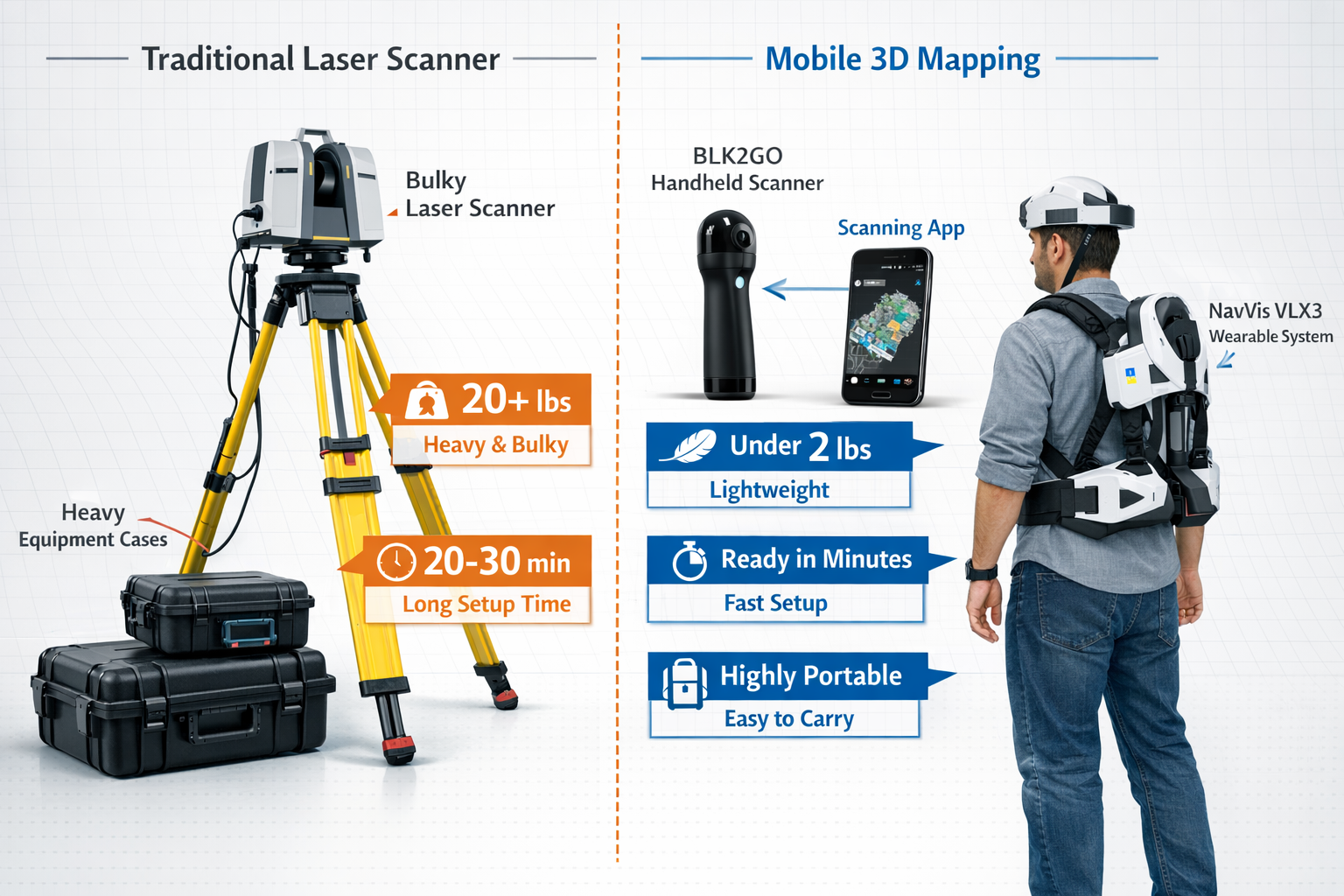
The days of hauling heavy tripods, bulky laser scanners, and cumbersome cables through property sites are rapidly fading. In 2026, Mobile 3D Mapping for Property Surveys: Creating Digital Twins Without Bulky Gear has transformed how surveyors capture, analyze, and deliver property data. What once required specialized teams and days of setup can now be accomplished by a single surveyor with equipment that fits in a backpack—or even a pocket.
This revolution isn't just about convenience. Modern mobile mapping systems deliver survey-grade accuracy while dramatically reducing field time, minimizing disruption to active facilities, and creating comprehensive digital twins that integrate seamlessly with construction workflows. Whether conducting RICS building surveys or documenting complex commercial building surveys, today's surveyors have access to tools that would have seemed impossible just a few years ago.
Key Takeaways
✅ Wearable and handheld systems like NavVis VLX3 and BLK2GO enable continuous mobile mapping without traditional tripod setups, reducing field time by up to 75%
✅ Survey-grade accuracy is now achievable with portable equipment, with modern systems delivering engineering-grade precision suitable for construction documentation and BIM integration
✅ Digital twins have evolved from static 3D models to interactive, measurable platforms that update continuously and integrate directly with GIS and construction management systems
✅ Multi-platform capture approaches combining drones, handheld scanners, wearable systems, and even smartphones ensure complete coverage without data gaps
✅ Automated processing workflows transform raw scan data into operational digital twins within hours, not weeks, accelerating project timelines and decision-making
The Evolution of Property Survey Technology: From Tripods to Mobile Systems
Traditional Survey Challenges That Held the Industry Back
For decades, property surveying relied on equipment that demanded significant physical effort and time investment. Traditional total stations and tripod-mounted laser scanners required:
- Multiple setup positions to capture complete building coverage
- Heavy equipment transport often requiring multiple team members
- Controlled environments with minimal movement during scanning
- Extended site access causing disruption to building operations
- Specialized training limiting who could operate the equipment
These limitations meant that comprehensive 3D documentation was reserved for high-value projects where the cost and time investment could be justified. Many structural surveys and routine property assessments relied on manual measurements, photographs, and 2D drawings—methods that couldn't capture the full spatial complexity of modern buildings.
The Mobile Mapping Revolution of 2026 🚀
The landscape has changed dramatically. Mobile 3D Mapping for Property Surveys: Creating Digital Twins Without Bulky Gear represents a fundamental shift in how surveyors work. Modern systems have eliminated the traditional trade-off between portability and accuracy.
According to industry experts, "new user-friendly tools will enable even more comprehensive data collection" including "capture from mobile phones and robust mobile mapping systems," democratizing access to reality capture technology.[5]
Key technological advances include:
| Technology | Traditional System | Modern Mobile System |
|---|---|---|
| Weight | 15-30 kg with tripod | 2-5 kg handheld/wearable |
| Setup Time | 5-10 min per position | Continuous capture |
| Coverage Rate | 200-400 m²/hour | 1,000-3,000 m²/hour |
| Accuracy | ±2-3 mm | ±5-10 mm (survey-grade) |
| Operator Training | Weeks of certification | Hours of familiarization |
| Disruption | Requires area clearance | Walk-through capture |
Understanding Digital Twins in Property Surveying
Digital twins have evolved far beyond simple 3D visualizations. In 2026, they represent "high-fidelity, interactive 3D models that update continuously as new data is collected," enabling developers and planners to visualize property behavior under various conditions.[3]
Modern digital twins provide a "faithful, measurable, and exploitable representation" that allows users to:
- Measure distances, heights, and clearances with millimeter precision
- Extract precise geographic positions for any point in the model
- Integrate with BIM workflows for construction coordination
- Update continuously as building conditions change
- Share across teams as a "shared source of truth"[4]
This transformation makes digital twins practical tools for everyday surveying work, not just showcase projects for major developments.
Mobile 3D Mapping Technologies: The Tools Revolutionizing Property Surveys
Wearable Scanning Systems: Survey While You Walk
Wearable LiDAR systems represent perhaps the most significant advance in mobile mapping technology. Systems like the NavVis VLX3 allow surveyors to capture continuous 3D data simply by walking through a property at normal pace.
The geoConvergence Scan2Twin methodology demonstrates this approach, combining NavVis VLX3 wearable systems for continuous mobile mapping with comprehensive environment capture.[2] These systems typically include:
- Multiple LiDAR sensors providing 360° coverage
- Panoramic cameras capturing photorealistic imagery
- Simultaneous Localization and Mapping (SLAM) technology for real-time positioning
- Inertial Measurement Units (IMUs) ensuring accuracy during movement
Practical advantages for surveyors:
✔️ Capture while walking at 1-1.5 m/s through buildings
✔️ No line-of-sight requirements to external reference points
✔️ Automatic registration of multiple floors and spaces
✔️ Minimal training required for operation
✔️ Survey-grade accuracy suitable for construction documentation
For homebuyer surveys and property inspections, wearable systems enable complete interior documentation in a fraction of traditional survey time.
Handheld Scanners: Precision in Your Palm
Handheld 3D scanners like the BLK2GO provide the perfect complement to wearable systems, offering enhanced detail capture in specific areas while maintaining complete portability.
These devices combine:
- Dual-axis LiDAR for rapid point cloud capture
- Three panoramic cameras for visual context
- SLAM-based navigation eliminating the need for targets
- Real-time visualization showing captured data on integrated screens
The Scan2Twin workflow uses BLK2GO handheld scanners specifically for detailed environment capture in areas requiring higher resolution or where wearable systems might be impractical.[2]
Ideal applications include:
- Detailed documentation of building defects
- Confined space surveys
- Ornamental feature capture
- Equipment room documentation
- Supplementing wearable system data
Robotic Platforms: Accessing the Inaccessible 🤖
One of the most innovative developments in Mobile 3D Mapping for Property Surveys: Creating Digital Twins Without Bulky Gear is the integration of robotic quadrupeds for accessing restricted or low-clearance spaces.[2]
These four-legged robots equipped with scanning systems can:
- Navigate stairs, rubble, and uneven terrain
- Access crawl spaces and low-clearance areas
- Survey hazardous environments without human risk
- Operate in darkness or poor visibility
- Capture data in areas where traditional equipment cannot reach
For structural engineering assessments and monitoring surveys, robotic platforms ensure complete documentation without compromising surveyor safety or data quality.
Smartphone-Based Capture: The Ultimate Accessibility
Perhaps the most democratizing trend is the emergence of viable smartphone-based 3D capture. Modern smartphones equipped with LiDAR sensors (like iPhone Pro models) can now perform legitimate reality capture work.[5]
Capabilities include:
- Room-scale scanning with ±2-5 cm accuracy
- Rapid documentation for preliminary assessments
- Instant sharing with clients and team members
- Integration with professional workflows
- Zero additional equipment cost for many surveyors
While not replacing professional-grade systems for final deliverables, smartphone capture enables rapid preliminary surveys, client communication, and documentation of changing conditions between formal surveys.
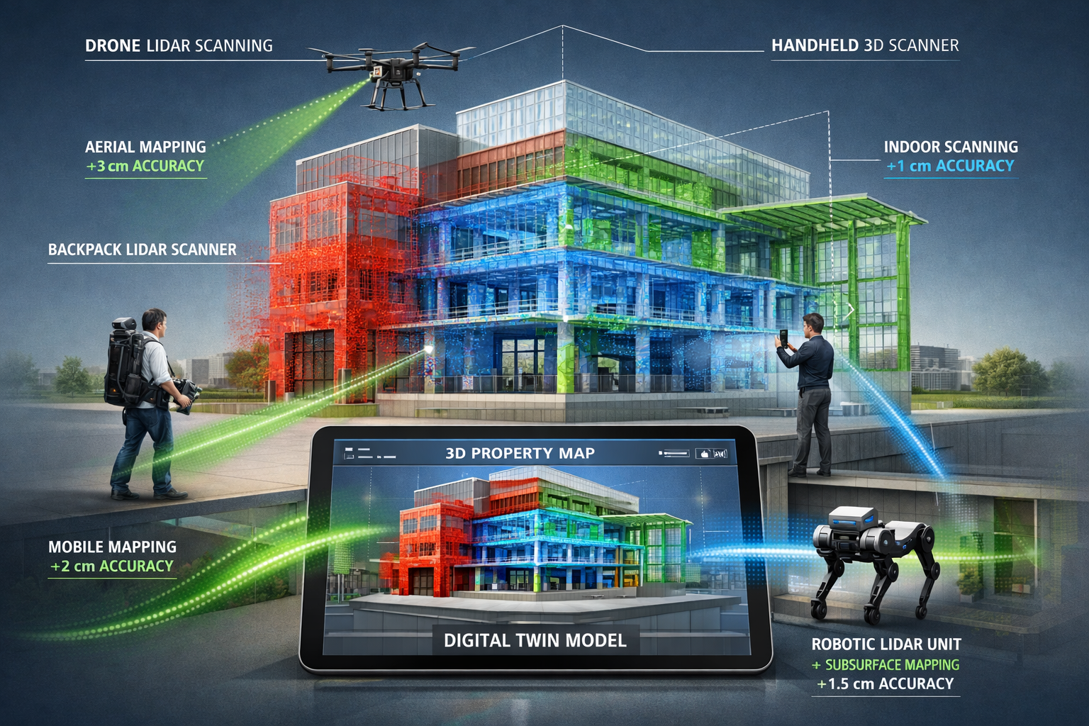
Multi-Platform Integration: Eliminating Data Gaps
Single-platform capture inevitably creates gaps in coverage. The AlphaUni 900 system exemplifies the multi-platform approach, capturing complete 3D data from drones, vehicles, backpacks, and boats to overcome point cloud gaps created by single-platform capture.[1]
Comprehensive coverage strategies combine:
| Platform | Best For | Typical Accuracy |
|---|---|---|
| Aerial Drones | Roof surveys, site context, large areas | ±3-5 cm |
| Vehicle-Mounted | Street frontages, large campuses | ±1-2 cm |
| Backpack/Wearable | Building interiors, pedestrian areas | ±5-10 mm |
| Handheld | Detail areas, confined spaces | ±5-10 mm |
| Robotic | Hazardous areas, crawl spaces | ±1-2 cm |
| Smartphone | Quick documentation, client communication | ±2-5 cm |
This multi-platform approach ensures that comparing different types of survey reveals comprehensive data rather than coverage limitations.
Implementing Mobile 3D Mapping: Practical Workflows for Property Surveyors
Pre-Survey Planning: Maximizing Efficiency
Successful Mobile 3D Mapping for Property Surveys: Creating Digital Twins Without Bulky Gear begins with proper planning. Unlike traditional surveys where equipment dictated methodology, mobile systems offer flexibility that requires strategic thinking.
Essential planning steps:
- Define deliverable requirements – Determine accuracy needs, output formats (BIM, GIS, PDF), and client specifications
- Assess site conditions – Identify challenging areas (reflective surfaces, narrow passages, outdoor/indoor transitions)
- Select appropriate platforms – Match equipment to site characteristics and deliverable requirements
- Plan capture routes – Design efficient paths ensuring complete coverage and loop closures
- Coordinate site access – Arrange timing to minimize disruption while ensuring adequate access
- Prepare data management – Ensure sufficient storage and processing capacity for point cloud data
Equipment checklist for typical property survey:
✅ Primary wearable or handheld scanner
✅ Smartphone for supplementary capture
✅ Portable battery packs (8-hour capacity minimum)
✅ Tablet for real-time data review
✅ Survey control targets (for accuracy verification)
✅ Backup storage devices
✅ Safety equipment appropriate to site
Field Capture Techniques: Speed Meets Accuracy
The Scan2Twin methodology demonstrates best practices for collecting survey-grade data from facility environments without disrupting operations.[2] This approach is particularly valuable for commercial building surveys where business continuity is essential.
Optimal capture techniques:
For Interior Spaces:
- Walk at consistent 1-1.5 m/s pace with wearable systems
- Maintain 2-3 meter distance from walls for optimal coverage
- Create loop closures every 50-100 meters to minimize drift
- Pause briefly in doorways to ensure clean transitions
- Use handheld scanners for detail areas after primary capture
- Document reflective surfaces (glass, mirrors) with supplementary photos
For Exterior Surveys:
- Begin with perimeter walk establishing site boundaries
- Integrate aerial drone data for roof and context
- Use vehicle-mounted systems for street frontages when available
- Ensure overlap between interior and exterior datasets
- Capture in consistent lighting conditions when possible
- Document control points for accuracy verification
For Mixed Environments:
- Plan routes minimizing indoor/outdoor transitions
- Allow scanners to stabilize when moving between environments
- Use handheld systems for challenging transition areas
- Capture outdoor areas during optimal weather conditions
- Document site conditions affecting data quality
Data Processing: From Point Clouds to Digital Twins
Modern workflows have dramatically simplified the transformation from raw scan data to usable digital twins. The Scan2Twin approach demonstrates automated BIM processing and ArcGIS Indoors deployment within 1-hour demonstration workflows.[2]
Processing workflow stages:
Stage 1: Registration and Alignment (Automated)
- SLAM algorithms automatically align scan positions
- Loop closure optimization minimizes accumulated drift
- Multi-platform data fusion combines different sensor types
- Accuracy verification against control points
- Typical processing time: 15-30 minutes for building-scale projects
Stage 2: Point Cloud Cleaning and Classification
- Automated noise removal filters erroneous points
- Classification algorithms identify walls, floors, ceilings, objects
- Privacy compliance tools automatically blur faces and license plates
- Vegetation and temporary object removal
- Typical processing time: 30-60 minutes
Stage 3: Model Generation
- Automated BIM extraction creates architectural elements
- Floor plan generation from point cloud data
- 3D mesh creation for visualization
- Texture mapping from panoramic imagery
- Typical processing time: 1-3 hours depending on detail level
Stage 4: Integration and Deployment
- GIS platform integration (ArcGIS, QGIS, etc.)
- BIM software compatibility (Revit, ArchiCAD, etc.)
- Cloud hosting for team access
- Mobile app deployment for field reference
- Typical setup time: 30-60 minutes
Privacy and Compliance: Automated Anonymization
Modern mobile mapping systems capture extensive visual information, raising important privacy considerations. Scan2Twin includes automated anonymization ensuring HIPAA and Personally Identifiable Information (PII) compliance,[2] addressing privacy concerns particularly relevant for healthcare facilities and residential properties.
Automated privacy protection includes:
- Facial blurring in panoramic imagery
- License plate anonymization in parking areas
- Document text obscuring on visible papers and screens
- Personal item removal from final deliverables
- Selective area masking for sensitive locations
For RICS home surveys and residential assessments, these automated privacy tools ensure compliance while maintaining the utility of captured data.
Quality Assurance: Ensuring Survey-Grade Results
Mobile systems' ease of use can create false confidence. Maintaining survey-grade accuracy requires systematic quality assurance.
Essential QA procedures:
During Capture:
- Monitor real-time data quality indicators
- Verify loop closures show acceptable error (<1:1000)
- Check coverage completeness before leaving site
- Document any areas requiring re-capture
- Capture redundant data in critical areas
During Processing:
- Verify registration accuracy against control points
- Check point cloud density meets project requirements
- Validate measurements against known dimensions
- Review automated classifications for errors
- Test exported models in target software platforms
Before Delivery:
- Generate accuracy report documenting precision
- Compare digital twin measurements to field checks
- Verify all required areas are captured
- Test client access to deliverables
- Provide metadata documenting capture methods and accuracy
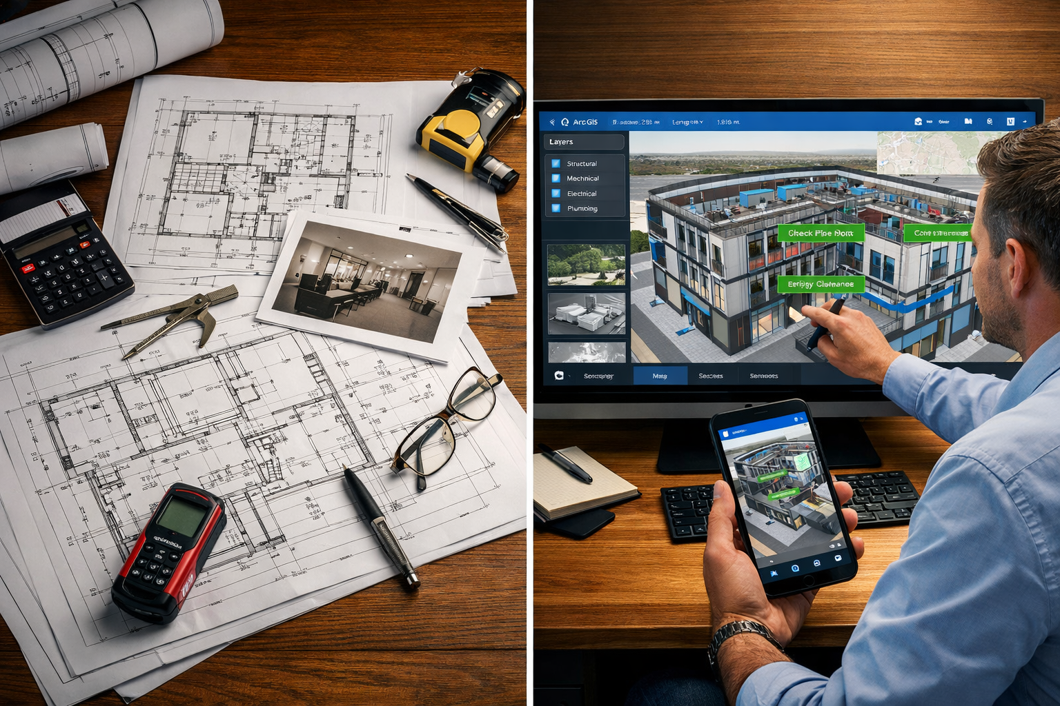
Integration with Construction and BIM Workflows
Seamless BIM Integration: From Scan to Model
The true power of Mobile 3D Mapping for Property Surveys: Creating Digital Twins Without Bulky Gear emerges when digital twins integrate seamlessly with Building Information Modeling (BIM) workflows used throughout construction projects.
Modern processing pipelines automatically transform raw scans into operational digital twins through automated BIM processing,[2] creating models that construction teams can immediately use for:
Design Phase Applications:
- As-built verification comparing existing conditions to original plans
- Clash detection identifying conflicts before construction begins
- Quantity takeoffs extracting accurate material requirements
- Design overlay visualizing proposed changes in context
- Client visualization communicating design intent clearly
Construction Phase Applications:
- Progress monitoring comparing built work to BIM models
- Quality control verifying installation accuracy
- Coordination resolving multi-trade conflicts in the field
- Change documentation recording deviations from plans
- Safety planning identifying hazards and access routes
Facility Management Applications:
- Maintenance planning accessing accurate spatial data
- Space management optimizing facility utilization
- Emergency response providing first responders accurate layouts
- Renovation planning working from current conditions, not outdated drawings
- Asset tracking locating equipment and systems precisely
GIS Platform Integration: The Esri-Native Advantage
One of the key adoption drivers for modern mobile mapping is integration with existing GIS platforms. The geoConvergence Esri-native pipeline for Scan2Twin "requires no custom development, aligning with how organizations already buy and run GIS," reducing implementation barriers.[2]
Benefits of native GIS integration:
✅ No workflow disruption – Works within existing software ecosystems
✅ Familiar interfaces – Teams use tools they already know
✅ Centralized data management – Single source of truth for spatial data
✅ Multi-scale analysis – Connect building-scale data to city-wide GIS
✅ Automated updates – Digital twins refresh as new surveys occur
For organizations conducting stock condition surveys across multiple properties, GIS integration enables portfolio-wide analysis and strategic planning based on current, accurate spatial data.
Real-Time Collaboration: Shared Digital Twins
Modern digital twins transform territory into a "shared source of truth"[4] accessible to all project stakeholders simultaneously. Cloud-based platforms enable:
Stakeholder Access:
- Clients review survey findings remotely without site visits
- Designers work from accurate existing conditions
- Contractors plan work based on current spatial data
- Facility managers access building information for operations
- Regulatory authorities review compliance documentation
Collaborative Features:
- Annotation tools allowing team members to mark issues
- Measurement capabilities enabling anyone to verify dimensions
- Version control tracking changes over time
- Access permissions controlling who sees sensitive information
- Mobile access providing field teams real-time reference data
Case Study: Large-Scale Digital Twin Deployment
Recent implementations demonstrate the scalability of mobile mapping approaches. Skytech Cambridge captured more than 40,000 high-resolution aerial photographs for 3D digital twin mapping of a new town development as of January 14, 2026.[8]
This large-scale project illustrates several key principles:
Multi-Platform Integration:
- Aerial photography for site context and topography
- Mobile ground-based capture for building details
- Handheld scanning for interior documentation
- Integration into single comprehensive digital twin
Phased Deployment:
- Initial baseline capture establishing existing conditions
- Progressive updates as construction advances
- Final as-built documentation for facility handover
- Ongoing maintenance updates for facility management
Stakeholder Value:
- Developers visualize progress and marketing materials
- Planners verify compliance with master plan
- Contractors coordinate across multiple sites
- Future residents explore their community before completion
Accuracy, Speed, and Cost: The Mobile Mapping Value Proposition
Accuracy Comparison: Mobile vs. Traditional Systems
A common misconception is that mobile systems sacrifice accuracy for convenience. Modern Mobile 3D Mapping for Property Surveys: Creating Digital Twins Without Bulky Gear delivers engineering-grade precision suitable for construction documentation.[4]
Accuracy benchmarks for 2026 systems:
| Application | Required Accuracy | Mobile System Performance | Traditional System Performance |
|---|---|---|---|
| Site Planning | ±5-10 cm | ✅ Exceeds requirements | ✅ Exceeds requirements |
| Building Facades | ±1-2 cm | ✅ Meets requirements | ✅ Exceeds requirements |
| Interior Layouts | ±5-10 mm | ✅ Meets requirements | ✅ Meets requirements |
| Structural Monitoring | ±2-5 mm | ⚠️ Suitable for many applications | ✅ Optimal choice |
| MEP Documentation | ±1-2 cm | ✅ Meets requirements | ✅ Meets requirements |
| Deformation Analysis | ±1-2 mm | ❌ Insufficient precision | ✅ Required approach |
For the vast majority of property surveying applications—including RICS building surveys Level 3 and routine documentation—mobile systems provide more than adequate accuracy while delivering substantial time and cost savings.
Time Efficiency: Quantifying the Speed Advantage ⚡
The time savings from mobile mapping systems are dramatic and measurable:
Typical 2,000 m² commercial building survey:
Traditional Tripod-Based Approach:
- Setup and calibration: 1 hour
- 15-20 scan positions: 4-5 hours
- Equipment movement: 1 hour
- Total field time: 6-7 hours
- Post-processing: 8-12 hours
- Total project time: 14-19 hours
Mobile Wearable System Approach:
- Equipment preparation: 15 minutes
- Continuous capture: 1-1.5 hours
- Detail area supplementation: 30 minutes
- Total field time: 2-2.5 hours
- Automated processing: 2-3 hours
- Total project time: 4-5.5 hours
Time savings: 60-70% reduction in total project duration
This efficiency enables surveyors to:
- Complete more projects with the same resources
- Offer faster turnaround times to clients
- Reduce site access requirements and disruption
- Respond quickly to urgent survey needs
- Allocate more time to analysis and reporting
Cost Analysis: Investment and ROI
While mobile mapping systems represent significant upfront investment, the return on investment typically materializes quickly for active surveying practices.
Equipment investment ranges (2026 pricing):
- Professional wearable system: £40,000-£80,000
- Handheld scanner: £15,000-£35,000
- Smartphone with LiDAR: £1,000-£1,500 (consumer device)
- Processing software: £2,000-£10,000 annual subscription
- Training and certification: £2,000-£5,000 per operator
Operating cost comparison (per project):
Traditional Survey Approach:
- Labor (2 operators × 7 hours): £700-£1,050
- Equipment depreciation: £100-£150
- Transportation and setup: £100-£200
- Processing time (12 hours): £600-£900
- Total project cost: £1,500-£2,300
Mobile Mapping Approach:
- Labor (1 operator × 2.5 hours): £125-£190
- Equipment depreciation: £150-£250
- Transportation: £50-£100
- Processing time (3 hours): £150-£225
- Total project cost: £475-£765
Cost savings per project: 60-70% reduction
ROI calculation for typical surveying practice:
Assuming 50 building surveys annually:
- Annual savings: £51,250-£76,750
- Equipment investment: £60,000-£90,000
- Payback period: 12-18 months
Additional value beyond direct cost savings:
- Competitive advantage from faster turnaround
- Ability to accept more projects with same staff
- Higher client satisfaction from comprehensive deliverables
- Reduced liability from more complete documentation
- New service offerings (digital twins, BIM integration)
Operational Benefits: Beyond Numbers
The value proposition extends beyond quantifiable metrics:
Surveyor Benefits:
- Reduced physical strain from carrying heavy equipment
- Enhanced safety through minimal setup requirements
- Greater job satisfaction using modern technology
- Professional development acquiring valuable digital skills
- Work-life balance from faster project completion
Client Benefits:
- Minimal disruption to building operations during surveys
- Comprehensive documentation exceeding traditional deliverables
- Interactive access to survey data through digital twins
- Future-proof data usable for ongoing facility management
- Faster project timelines from rapid survey turnaround
For practices offering damp surveys and specialized assessments, mobile mapping enables comprehensive documentation that supports detailed analysis while maintaining rapid project completion.
Future Trends and Emerging Technologies in Mobile 3D Mapping
Continuous Digital Twins: Real-Time Updates
The digital twin standard for 2026 emphasizes continuous updating. Modern systems create "high-fidelity, interactive 3D models that update continuously as new data is collected,"[3] moving beyond static snapshots to living representations of properties.
Emerging continuous monitoring approaches:
Permanent Sensor Integration:
- Fixed scanners at strategic locations
- Automated periodic capture schedules
- Change detection algorithms identifying modifications
- Alert systems notifying stakeholders of significant changes
- Progressive accuracy improvement through data accumulation
Mobile Periodic Updates:
- Quarterly or annual re-surveys using same methodology
- Automated comparison highlighting changes
- Version control tracking building evolution
- Deformation monitoring for structural health
- Compliance verification for facility management
This continuous approach particularly benefits monitoring surveys where tracking changes over time provides critical insights into building performance and structural integrity.
AI and Machine Learning: Intelligent Processing
Artificial intelligence is transforming how captured data becomes actionable information:
Automated Feature Extraction:
- AI identifies building elements (walls, doors, windows, equipment)
- Machine learning classifies materials and conditions
- Defect detection highlights potential issues
- Automated measurement extraction reduces manual processing
- Intelligent segmentation separates building systems
Predictive Analytics:
- Pattern recognition identifying maintenance needs
- Deterioration modeling predicting future conditions
- Energy performance analysis from building geometry
- Space utilization optimization from occupancy patterns
- Risk assessment for insurance and compliance
Natural Language Interfaces:
- Voice queries to digital twin databases
- Automated report generation from scan data
- Conversational interaction with building information
- Intelligent search across multiple properties
- Accessibility improvements for non-technical users
Augmented Reality: Bridging Digital and Physical
AR technology is creating powerful new applications for mobile mapping data:
Field Applications:
- Overlay digital twin data on physical spaces through tablets or AR glasses
- Visualize hidden building systems (pipes, wiring, structure)
- Compare as-built conditions to original plans in real-time
- Guide maintenance technicians to specific locations
- Training simulations using accurate spatial data
Client Communication:
- Walk clients through proposed changes in context
- Demonstrate survey findings with visual overlays
- Interactive property tours combining real and digital
- Before/after visualizations for renovation projects
- Remote collaboration with shared AR experiences
Democratization Through Smartphone Technology
The trend toward smartphone-based capture continues accelerating. Industry experts confirm that mobile phone capture is becoming viable for professional reality capture work,[5] expanding access to 3D documentation far beyond specialized surveying firms.
Implications for the surveying profession:
Opportunities:
- Preliminary assessments by non-specialists
- Client self-documentation for initial consultations
- Rapid change documentation between formal surveys
- Broader market awareness of 3D documentation value
- New service models combining professional and client capture
Challenges:
- Quality control for non-professional capture
- Managing client expectations about accuracy
- Differentiating professional services from consumer tools
- Liability considerations for hybrid workflows
- Maintaining professional standards amid democratization
Strategic responses:
- Offer tiered services matching tool capabilities to requirements
- Educate clients about appropriate applications for different systems
- Develop quality assurance protocols for client-provided data
- Focus professional services on analysis and interpretation
- Embrace smartphone tools for preliminary and supplementary work
Sustainability and Environmental Monitoring
Mobile mapping technology increasingly supports environmental and sustainability objectives:
Energy Efficiency Analysis:
- Thermal imaging integration identifying heat loss
- Building envelope analysis from accurate geometry
- Solar potential assessment from roof models
- Natural lighting analysis for retrofit planning
- HVAC optimization using spatial data
Environmental Documentation:
- Habitat mapping for ecological assessments
- Vegetation monitoring and change detection
- Flood risk modeling from accurate topography
- Green infrastructure planning and monitoring
- Climate adaptation strategy development
Carbon Footprint Reduction:
- Reduced site visits through comprehensive initial capture
- Digital collaboration reducing travel requirements
- Optimized renovation planning minimizing waste
- Lifecycle analysis supported by accurate as-built data
- Embodied carbon assessment for existing buildings
Practical Recommendations for Surveyors Adopting Mobile 3D Mapping
Getting Started: Phased Implementation Strategy
Successful adoption of Mobile 3D Mapping for Property Surveys: Creating Digital Twins Without Bulky Gear doesn't require immediate wholesale transformation. A phased approach manages risk while building capability.
Phase 1: Assessment and Planning (1-2 months)
Actions:
- Analyze current project mix identifying best initial applications
- Research equipment options matching typical project requirements
- Attend demonstrations and trial different systems
- Develop business case quantifying expected ROI
- Identify training needs and resource requirements
Recommended first projects:
- Medium-complexity buildings (1,000-3,000 m²)
- Clients open to innovative approaches
- Projects with flexible timelines allowing learning
- Properties with good access and typical conditions
- Opportunities to demonstrate value through digital twins
Phase 2: Initial Equipment and Training (2-3 months)
Investment priorities:
- Start with one versatile system (handheld or wearable)
- Invest in robust processing software and hardware
- Allocate adequate training time for operators
- Establish data management and backup protocols
- Develop quality assurance procedures
Training focus:
- Equipment operation and troubleshooting
- Capture planning and route optimization
- Processing software proficiency
- Quality control and accuracy verification
- Client communication about new deliverables
Phase 3: Pilot Projects and Refinement (3-6 months)
Implementation:
- Execute 5-10 pilot projects with new equipment
- Document time, cost, and quality metrics
- Gather client feedback on deliverables
- Refine workflows based on experience
- Develop standard operating procedures
Success metrics:
- Field time reduction vs. traditional methods
- Processing efficiency and automation level
- Client satisfaction with digital twin deliverables
- Accuracy verification against requirements
- Operator confidence and proficiency
Phase 4: Full Integration and Expansion (6-12 months)
Scale-up activities:
- Expand equipment inventory for capacity
- Train additional team members
- Integrate with existing workflows and software
- Develop marketing materials showcasing capabilities
- Establish premium pricing for enhanced deliverables
Advanced capabilities:
- Multi-platform integration (drone, vehicle, handheld)
- BIM and GIS platform integration
- Automated processing pipelines
- Cloud-based client access portals
- Subscription-based monitoring services
Selecting the Right Equipment for Your Practice
Equipment selection should align with typical project characteristics and business objectives:
For Residential Survey Practices:
- Primary tool: Handheld scanner (BLK2GO or equivalent)
- Supplementary: Smartphone with LiDAR for quick assessments
- Rationale: Flexibility for varied property sizes, ease of transport, sufficient accuracy for residential applications
- Investment: £15,000-£25,000 initial equipment
For Commercial Building Surveyors:
- Primary tool: Wearable system (NavVis VLX3 or equivalent)
- Supplementary: Handheld scanner for detail areas
- Rationale: Efficiency for large spaces, continuous capture, professional-grade deliverables
- Investment: £50,000-£90,000 initial equipment
For Multi-Discipline Practices:
- Primary tools: Both wearable and handheld systems
- Supplementary: Drone for aerial capture, vehicle-mounted for large sites
- Rationale: Maximum flexibility, comprehensive coverage, competitive differentiation
- Investment: £80,000-£150,000 initial equipment
For Specialized Applications:
- Structural monitoring: High-accuracy static scanner supplemented by mobile for context
- Heritage documentation: Handheld for detail, drone for inaccessible features
- Facility management: Wearable for efficiency, permanent sensors for continuous monitoring
Building Client Demand for Digital Twin Deliverables
Mobile mapping technology enables new service offerings that command premium pricing:
Value-Added Services:
Interactive Digital Twins:
- Cloud-hosted 3D models accessible from any device
- Measurement tools allowing clients to verify dimensions
- Annotation capabilities for planning and communication
- Integration with client's facility management systems
- Subscription-based access with periodic updates
BIM-Ready Documentation:
- Automated architectural model extraction
- Revit/ArchiCAD native format deliverables
- Clash detection for renovation planning
- Quantity takeoff support for cost estimation
- As-built verification for construction projects
Specialized Analysis:
- Space utilization studies from accurate floor plans
- Energy efficiency assessments combining geometry and thermal data
- Accessibility compliance verification
- Heritage documentation for historic properties
- Deformation monitoring for structural concerns
Marketing approaches:
✅ Case studies demonstrating time and cost savings
✅ Interactive demonstrations letting clients explore digital twins
✅ Educational content explaining digital twin benefits
✅ Tiered service offerings from basic to premium deliverables
✅ Partnership development with architects, contractors, facility managers
Quality Standards and Professional Certification
As mobile mapping becomes mainstream, maintaining professional standards ensures credibility:
Industry Standards:
- Follow RICS guidance on 3D surveying methodologies
- Adopt ISO 19650 BIM standards for deliverables
- Implement quality management systems (ISO 9001)
- Document accuracy verification procedures
- Maintain professional indemnity insurance coverage
Certification and Training:
- Manufacturer certification for equipment operation
- Professional development in digital workflows
- BIM and GIS software proficiency
- Health and safety training for mobile operations
- Continuing professional development documentation
Deliverable Documentation:
- Accuracy statements with every project
- Methodology descriptions explaining capture approach
- Metadata documenting equipment, settings, conditions
- Quality assurance reports verifying standards compliance
- User guides helping clients utilize digital twins
For practices offering comprehensive RICS home surveys and professional building assessments, maintaining these standards differentiates professional services from consumer-grade alternatives.
Overcoming Common Implementation Challenges
Challenge: High Initial Investment
Solutions:
- Start with single versatile system rather than complete suite
- Consider equipment leasing or financing options
- Focus initial projects on high-value applications justifying premium pricing
- Partner with other firms to share equipment costs
- Quantify ROI through pilot projects before major investment
Challenge: Learning Curve and Training Time
Solutions:
- Allocate dedicated training time without project pressure
- Start with simpler projects building to complex applications
- Utilize manufacturer training resources and support
- Develop internal documentation and standard procedures
- Pair experienced operators with trainees on initial projects
Challenge: Client Education and Expectation Management
Solutions:
- Provide clear examples of deliverables before project start
- Offer tiered service levels matching client needs and budgets
- Demonstrate digital twin capabilities through interactive presentations
- Explain accuracy limitations and appropriate applications
- Gather testimonials from satisfied clients for marketing
Challenge: Data Management and Storage Requirements
Solutions:
- Invest in adequate storage infrastructure (NAS, cloud backup)
- Implement systematic file naming and organization protocols
- Archive completed projects to secondary storage
- Utilize cloud processing services for large datasets
- Plan for 3-5 year data retention matching professional standards
Challenge: Integration with Existing Workflows
Solutions:
- Map current processes identifying integration points
- Utilize software with native compatibility to existing tools
- Develop hybrid workflows combining traditional and digital methods
- Allocate time for process refinement and optimization
- Seek vendor support for integration challenges
Conclusion: Embracing the Mobile Mapping Revolution
Mobile 3D Mapping for Property Surveys: Creating Digital Twins Without Bulky Gear represents far more than incremental improvement—it's a fundamental transformation in how surveyors capture, analyze, and deliver property information. The convergence of wearable systems, handheld scanners, robotic platforms, and even smartphones has eliminated the traditional trade-off between portability and precision.
In 2026, surveyors can walk through a building at normal pace and emerge with survey-grade 3D data that would have required days of traditional surveying. They can access spaces that were previously impossible to document. They can deliver interactive digital twins that clients can explore, measure, and analyze from anywhere in the world. And they can do all of this with equipment that fits in a backpack.
The Competitive Imperative
The question is no longer whether to adopt mobile mapping technology, but how quickly and strategically to implement it. Practices that embrace these tools gain:
✅ Competitive advantage through faster turnaround and comprehensive deliverables
✅ Operational efficiency reducing field time by 60-70% while improving data quality
✅ New revenue streams from digital twin services and ongoing monitoring
✅ Client satisfaction through innovative, value-added deliverables
✅ Professional development positioning teams at the forefront of surveying technology
Those who delay risk becoming obsolete as client expectations evolve and competitors demonstrate what's possible with modern technology.
Actionable Next Steps 🎯
For Surveying Practices Ready to Begin:
- Conduct immediate assessment of current project mix identifying 10-15 projects that would benefit from mobile mapping
- Schedule equipment demonstrations with 2-3 vendors within the next month
- Develop business case quantifying expected ROI based on your typical project volumes and pricing
- Allocate training budget for operator certification and skill development
- Identify pilot projects with clients open to innovative approaches and flexible timelines
For Practices Already Using Mobile Mapping:
- Evaluate workflow efficiency identifying bottlenecks in capture or processing
- Expand service offerings developing premium digital twin deliverables
- Invest in integration connecting mobile mapping to BIM and GIS platforms
- Develop case studies documenting time savings and client value
- Consider multi-platform expansion adding drone or vehicle-mounted systems for comprehensive coverage
For Property Owners and Developers:
- Request digital twin deliverables when commissioning surveys
- Evaluate surveyor capabilities ensuring they utilize modern mobile mapping technology
- Invest in facility management platforms that leverage digital twin data
- Implement continuous monitoring for high-value or critical facilities
- Explore BIM integration connecting survey data to construction and operations workflows
The Path Forward
The technology enabling Mobile 3D Mapping for Property Surveys: Creating Digital Twins Without Bulky Gear will continue advancing rapidly. Smartphone capabilities will improve. AI will automate more processing tasks. Integration will become seamless. And the distinction between physical properties and their digital twins will blur as continuous monitoring becomes standard practice.
Surveyors who position themselves at the forefront of this transformation—combining professional expertise with cutting-edge technology—will define the future of the profession. The tools are available. The workflows are proven. The ROI is compelling.
The only question is: when will you begin?
For professional guidance on implementing mobile 3D mapping for your specific surveying needs, or to discuss how digital twins can enhance your property assessment requirements, contact experienced chartered building surveyors who can help you navigate this technological transformation while maintaining the professional standards that clients expect and deserve.
References
[1] Using Mobile Mapping And Airborne Lidar Scanning To Create Digital Twins – https://geo-matching.com/articles/using-mobile-mapping-and-airborne-lidar-scanning-to-create-digital-twins
[2] Geoconvergence Introduces Scan2twin Mobile Mapping For Digital Twin Creation Gis Integration – https://www.geoweeknews.com/news/geoconvergence-introduces-scan2twin-mobile-mapping-for-digital-twin-creation-gis-integration
[3] Future Land Surveying 2026 – https://haller-blanchard.com/future-land-surveying-2026/
[4] Le Jumeau Numérique Comme Socle Des Décisions Urbaines – https://www.jakarto.com/en/blog/le-jumeau-num%C3%A9rique-comme-socle-des-d%C3%A9cisions-urbaines
[5] Doubling Down On Digital – https://amerisurv.com/2026/02/01/doubling-down-on-digital/
[6] Reconstruct – https://www.nianticspatial.com/en/products/reconstruct
[7] Mapping The Future Critical Geospatial Trends For 2026 – https://woolpert.com/mapping-the-future-critical-geospatial-trends-for-2026/
[8] Mobile Mapping – https://www.gim-international.com/themes/mobile-mapping