Imagine standing on a vacant lot, trying to visualize underground utilities, zoning restrictions, property boundaries, and future development potential—all at once. For decades, this required juggling multiple paper maps, regulatory documents, and site visits. In 2026, GIS integration in property surveying has transformed this complex puzzle into an interactive, multi-layered digital experience that revolutionizes how professionals manage and analyze land data.
GIS Integration in Property Surveying: Streamlining Data Management and Analysis represents one of the most significant technological advances in the land development industry. By combining geographic information systems with traditional surveying practices, professionals can now overlay zoning regulations, property boundaries, utility networks, and environmental constraints in a single, comprehensive view. This integration eliminates data silos, reduces errors, and accelerates decision-making processes that once took weeks into mere hours.
The transformation is particularly timely. With the 2026 ALTA/NSPS standards emphasizing enhanced transparency and precision, and the National Spatial Reference System undergoing its first major modernization in nearly 40 years, the surveying industry stands at a technological crossroads[1][2]. Cloud-based GIS platforms now enable real-time collaboration among surveyors, engineers, planners, and stakeholders—fundamentally changing how land development projects unfold.
Key Takeaways
- 🗺️ Multi-layered visualization through GIS integration allows surveyors to overlay zoning, boundaries, utilities, and environmental data for comprehensive property analysis
- ☁️ Cloud-based GIS platforms enable real-time collaboration among multiple stakeholders, reducing project timelines by up to 70%
- 📊 Enhanced data accuracy results from integrating the modernized National Spatial Reference System (NSRS) with survey-grade GIS tools
- 📈 Properties featuring 3D virtual building models are 20x more likely to be clicked and 10x more likely to be shared compared to traditional presentations[4]
- ⚖️ The 2026 ALTA/NSPS standards require more comprehensive documentation of easements, utilities, and boundary discrepancies—making GIS integration essential for compliance[1]
Understanding GIS Integration in Modern Property Surveying
What Is GIS Integration in Property Surveying?
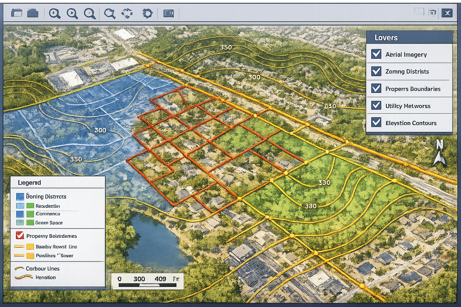
Geographic Information System (GIS) integration in property surveying refers to the systematic combination of spatial data, surveying measurements, and geographic analysis tools into a unified digital platform. Rather than maintaining separate databases for boundary surveys, topographic information, zoning regulations, and utility locations, integrated GIS creates a single source of truth where all spatial data coexists and interacts.
This integration fundamentally changes how surveyors approach their work. Traditional surveying focused primarily on establishing precise property boundaries and elevations. While accuracy remains paramount, modern GIS-integrated surveying adds layers of contextual intelligence—showing not just where boundaries exist, but how they relate to zoning districts, flood zones, utility easements, environmental restrictions, and development opportunities.
The practical benefits are substantial. When conducting commercial property surveying, professionals can instantly access historical survey data, overlay current zoning maps, identify utility conflicts, and generate comprehensive reports—all from a single integrated platform.
The Evolution from Paper Maps to Digital Layers
The journey toward GIS integration represents decades of technological evolution. In the 1980s and 1990s, surveyors began transitioning from hand-drawn plats to Computer-Aided Design (CAD) systems. While CAD improved drafting efficiency, it remained fundamentally two-dimensional and disconnected from broader geographic context.
The real transformation began when surveying data merged with geospatial databases. Modern GIS platforms like ArcGIS Pro and MicroStation—now adopted by organizations including the United States Army Corps of Engineers—produce multi-dimensional views that incorporate temporal data, allowing users to visualize how properties and infrastructure have changed over time[3].
Today's GIS-integrated surveying workflow typically includes:
- Field data collection using GPS-enabled total stations and drones
- Real-time data upload to cloud-based GIS platforms
- Automated quality control comparing new measurements against historical records
- Multi-layer analysis incorporating zoning, utilities, environmental constraints
- Interactive reporting with stakeholder collaboration features
Core Components of GIS-Integrated Surveying Systems
A comprehensive GIS integration for property surveying consists of several interconnected components:
| Component | Function | Key Benefits |
|---|---|---|
| Spatial Database | Stores georeferenced survey data, property boundaries, and attribute information | Centralized data repository, version control, historical tracking |
| Data Collection Tools | GPS receivers, total stations, drones, mobile GIS apps | Real-time field data capture, automatic coordinate transformation |
| Analysis Engine | Performs spatial queries, overlay analysis, buffer calculations | Identifies conflicts, measures distances, calculates areas |
| Visualization Platform | Creates interactive maps, 3D models, and layered views | Enhanced stakeholder communication, better decision-making |
| Cloud Infrastructure | Provides secure storage, remote access, and collaboration features | Multi-user access, automatic backups, scalability |
The integration of these components creates a seamless workflow from field measurement to final deliverable. For example, when conducting structural surveys, surveyors can immediately compare current building positions against recorded easements, setback requirements, and neighboring property lines—identifying potential encroachments before they become legal disputes.
How GIS Overlays Transform Property Data Visualization and Analysis
Layering Zoning Districts for Development Planning
One of the most powerful applications of GIS Integration in Property Surveying: Streamlining Data Management and Analysis involves overlaying zoning information with property boundaries. Zoning districts determine what can be built, how tall structures can be, required setbacks, parking requirements, and permitted uses—making this data critical for any development project.
Traditional zoning analysis required cross-referencing paper zoning maps with property surveys, often leading to misinterpretations and costly mistakes. GIS integration eliminates this friction by creating transparent overlay layers that show exactly how zoning boundaries intersect with property lines.
Consider a typical scenario: A developer acquires a 5-acre parcel that straddles two zoning districts—one allowing commercial development and another restricted to residential use. With GIS integration, surveyors can:
✅ Precisely delineate the zoning boundary across the property
✅ Calculate exact acreage in each zoning district
✅ Identify setback requirements for each zone
✅ Visualize building envelopes showing where structures can be placed
✅ Generate reports showing development potential for each portion
This level of analysis, which once required days of manual calculation, now happens in minutes. The visual clarity also improves communication with clients, planning departments, and investors who may lack technical surveying expertise.
According to industry data, 96% of economic development professionals now provide or plan to provide property data on their websites, reflecting the growing expectation for accessible, visual property information[4]. GIS-integrated zoning overlays meet this demand while ensuring accuracy that paper maps simply cannot match.
Mapping Property Boundaries with Historical Context
Property boundaries represent the legal foundation of land ownership, making their accurate representation essential. GIS integration enhances boundary surveying by incorporating historical survey data, deed records, and previous ownership patterns into a comprehensive visual timeline.
The 2026 ALTA/NSPS standards place increased emphasis on boundary discrepancy reporting, requiring surveyors to disclose gaps or overlaps between parcels and explain significant differences between recorded dimensions and actual field measurements[1]. GIS platforms excel at this comparative analysis by:
- Overlaying current measurements against historical survey plats
- Highlighting discrepancies between recorded and measured distances
- Tracking boundary evolution through multiple ownership transfers
- Identifying potential encroachments by comparing building footprints against property lines
- Documenting evidence with georeferenced photographs and field notes
This historical context proves invaluable when resolving boundary disputes or conducting boundary surveys. Rather than presenting isolated measurements, surveyors can show how boundaries have been interpreted over decades, strengthening their professional opinions with documented evidence.
The integration also supports the new State Plane Coordinate System 2022 (SPCS 2022), which introduces flexible zone structures that reduce distortion over large areas[2]. By automatically transforming coordinates between different reference systems, GIS platforms ensure that historical surveys remain compatible with modern measurements—preserving decades of valuable boundary data.
Visualizing Utility Networks and Infrastructure
Underground utilities represent one of the greatest challenges in property development. Water lines, sewer systems, electrical conduits, gas mains, telecommunications cables, and stormwater infrastructure all occupy subsurface space—often with incomplete or inaccurate documentation.
GIS integration transforms utility management by creating comprehensive overlay maps that show:
🔵 Water infrastructure (supply lines, fire hydrants, valves)
🟤 Sanitary sewer systems (gravity mains, force mains, manholes)
⚡ Electrical networks (underground lines, transformers, service points)
🟡 Gas distribution (transmission lines, distribution mains, regulators)
🟢 Telecommunications (fiber optic cables, conduits, junction boxes)
🔷 Stormwater management (drainage pipes, catch basins, detention ponds)
The 2026 ALTA/NSPS standards significantly strengthen requirements for documenting easements, utilities, access, and encroachments[1]. Surveyors must now provide more detailed notes and clearer distinctions between documented information and physical evidence found on-site. GIS platforms support this requirement by:
- Maintaining separate layers for recorded easements versus observed utilities
- Color-coding confidence levels (surveyed, utility-marked, as-recorded, approximate)
- Linking documentation (utility company maps, easement documents, field photographs)
- Calculating clearances between proposed construction and existing utilities
- Generating conflict reports identifying potential utility strikes
This enhanced visualization prevents costly construction delays and safety hazards. When integrated with project management workflows, utility overlay data becomes accessible to engineers, contractors, and inspectors—ensuring everyone works from the same accurate information.
Environmental and Topographic Data Integration
Beyond man-made features, GIS integration incorporates natural and environmental data layers that influence development feasibility and design. These layers include:
- Topographic contours showing elevation changes and slope percentages
- Floodplain boundaries from FEMA flood insurance rate maps
- Wetland delineations from environmental surveys
- Soil classifications affecting foundation design and drainage
- Vegetation coverage requiring clearing permits
- Protected habitats with development restrictions
By overlaying these environmental constraints with property boundaries and zoning regulations, surveyors create a comprehensive development feasibility analysis. For instance, a GIS overlay might reveal that while a property is zoned for high-density residential development, 40% of the site lies within a 100-year floodplain and another 20% contains protected wetlands—dramatically reducing buildable area.
This integrated analysis prevents costly surprises during the permitting process. Developers can make informed acquisition decisions, and engineers can design around constraints from the project's inception rather than discovering them after significant investment.
The modernized National Spatial Reference System specifically supports these applications by providing consistent vertical datums through gravimetric-derived geopotential measurements[2]. This ensures that elevation-dependent analyses—such as flood risk assessment and drainage design—maintain accuracy across large geographic areas.
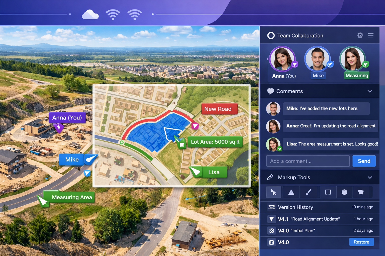
Cloud-Based GIS: Revolutionizing Collaborative Surveying in 2026
Real-Time Data Sharing Among Stakeholders
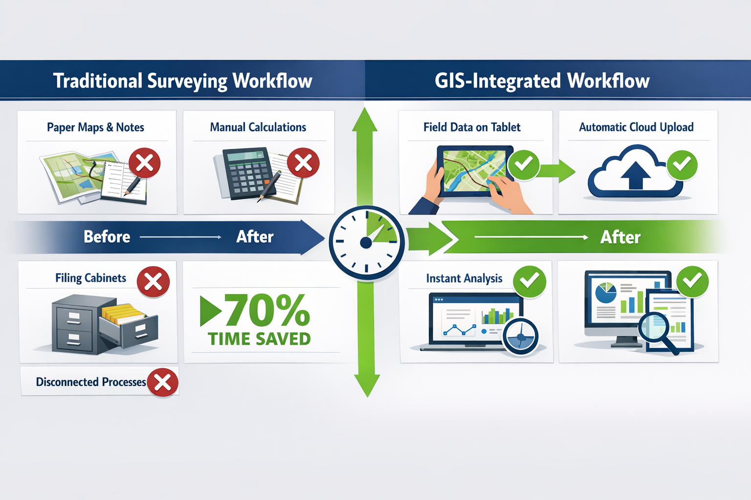
The shift to cloud-based GIS platforms represents perhaps the most transformative advancement in property surveying collaboration. Traditional surveying workflows involved sequential handoffs: surveyors collected data, returned to the office, processed measurements, created drawings, and delivered static PDF reports to clients. Any questions or revisions required another complete cycle.
Cloud-based GIS eliminates this bottleneck by enabling simultaneous access to survey data among all project stakeholders. In 2026, a typical land development project might involve:
- Surveyors collecting and uploading field measurements
- Civil engineers designing site improvements based on current topography
- Architects positioning buildings within surveyed property boundaries
- Environmental consultants delineating wetlands and protected areas
- Planning officials reviewing compliance with zoning requirements
- Utility companies marking existing infrastructure
- Developers monitoring progress and making decisions
With cloud-based GIS integration, all these professionals access the same live dataset. When a surveyor updates a boundary measurement, the civil engineer's site plan automatically reflects the change. When an environmental consultant adds a wetland delineation, the architect's building envelope adjusts accordingly.
This real-time collaboration reduces project timelines dramatically. According to industry research, 84% of surveying and property development organizations are using or adopting property data analytics for performance tracking[4]—a clear indicator of the industry's shift toward data-driven, collaborative workflows.
Multi-User Editing and Version Control
Collaborative editing introduces the challenge of data integrity—ensuring that multiple users don't create conflicting information or accidentally overwrite each other's work. Modern cloud-based GIS platforms address this through sophisticated version control systems borrowed from software development.
Key features include:
🔒 User Permissions and Roles
- Administrators control who can view, edit, or delete specific data layers
- Role-based access ensures only qualified professionals modify critical information
- Audit trails track every change with timestamp and user identification
📝 Check-Out/Check-In Systems
- Users "lock" features they're editing, preventing simultaneous conflicting edits
- Other users see real-time indicators showing which features are being modified
- Automatic notifications when locked features become available
⏮️ Version History and Rollback
- Complete history of all changes to every feature and attribute
- Side-by-side comparison of different versions
- One-click rollback to previous states if errors are discovered
🔄 Conflict Resolution Tools
- Automatic detection of conflicting edits
- Visual comparison interfaces showing differences
- Merge tools allowing selective acceptance of changes
This infrastructure proves particularly valuable for chartered surveyors managing complex projects with multiple team members. Rather than maintaining separate datasets that must be manually reconciled, the entire team works within a single, continuously synchronized environment.
Mobile GIS Applications for Field Data Collection
The proliferation of rugged tablets and smartphones has extended GIS integration directly into the field. Modern mobile GIS applications allow surveyors to:
✅ View live GIS layers while conducting fieldwork
✅ Collect new features with GPS-enabled devices
✅ Attach photographs georeferenced to specific locations
✅ Complete attribute forms with dropdown menus and validation rules
✅ Access background imagery for visual context
✅ Work offline in areas without cellular coverage, syncing when connectivity returns
This mobile capability transforms field efficiency. When locating property corners, surveyors can immediately see how their measurements compare to recorded dimensions. When documenting utilities, they can verify whether observed infrastructure matches utility company records. When noting encroachments, they can photograph evidence and link it directly to the affected boundary segment.
The integration between field and office becomes seamless. Data collected on a tablet at 2:00 PM appears in the cloud-based GIS by 2:01 PM, available for analysis by engineers and planners without any manual transfer process. This eliminates transcription errors and dramatically accelerates project delivery.
Government agencies have recognized this potential. The United States Army Corps of Engineers' Fort Worth District Real Estate Division has transitioned from traditional two-dimensional maps to MicroStation and ArcGIS Pro specifically to support multi-dimensional project visualization and mobile field data collection[3].
Integration with AI and Automated Analysis Tools
The modernized National Spatial Reference System was specifically designed to support emerging technologies including GeoAI, digital twins, and digital project delivery[2]. These artificial intelligence applications are already transforming how surveyors analyze property data in 2026.
Automated Feature Extraction
AI algorithms can analyze aerial imagery and LiDAR point clouds to automatically identify:
- Building footprints and roof structures
- Pavement and hardscape areas
- Vegetation coverage and tree canopy
- Drainage patterns and water features
- Utility infrastructure visible from above
Anomaly Detection
Machine learning models trained on thousands of surveys can flag:
- Boundary measurements that deviate significantly from recorded dimensions
- Potential encroachments based on building setbacks
- Utility conflicts where proposed construction intersects existing infrastructure
- Zoning violations where land use doesn't match permitted activities
Predictive Analytics
Historical survey data enables AI to predict:
- Areas prone to boundary disputes based on historical patterns
- Parcels likely to have undocumented easements
- Properties with high probability of utility conflicts
- Development sites requiring environmental assessments
These AI capabilities don't replace professional surveyor judgment—they augment it. By automating routine analysis tasks, AI allows surveyors to focus their expertise on complex interpretation, client communication, and problem-solving.
The integration also supports digital twin technology, where virtual replicas of physical properties continuously update with real-world changes. For large developments or municipal infrastructure, digital twins provide unprecedented visibility into asset conditions, maintenance needs, and development opportunities.
Benefits of GIS Integration in Property Surveying: Streamlining Data Management and Analysis
Enhanced Accuracy and Error Reduction
Accuracy represents the foundation of professional surveying, and GIS integration enhances it through multiple mechanisms. By maintaining centralized databases with built-in validation rules, GIS platforms prevent common errors that plague manual workflows.
Consider attribute accuracy: When a surveyor records a property boundary monument type, traditional paper forms allow any text entry—leading to inconsistencies like "iron pipe," "IP," "iron post," and "2-inch iron pipe" all describing the same monument type. GIS platforms use controlled vocabularies with dropdown menus, ensuring consistent terminology across all surveys.
Geometric accuracy benefits from automated coordinate transformation. The modernized National Spatial Reference System introduces new geometric reference frames for horizontal positioning and gravimetric-derived geopotential datums for vertical positioning[2]. GIS software automatically transforms measurements between these new systems and legacy datums, eliminating manual calculation errors.
The 2026 ALTA/NSPS standards' emphasis on documenting boundary discrepancies also benefits from GIS integration[1]. Rather than manually calculating differences between recorded and measured distances, GIS platforms perform these comparisons automatically, generating comprehensive discrepancy reports with visual overlays showing where conflicts exist.
Quality control workflows embedded in GIS platforms include:
- Topology rules preventing gaps or overlaps in parcel boundaries
- Coordinate precision validation ensuring measurements meet project specifications
- Closure analysis automatically checking traverse loop closures
- Attribute completeness checks flagging missing required information
- Cross-reference validation comparing survey data against deed descriptions
These automated checks catch errors before deliverables reach clients, protecting professional reputation and reducing liability exposure.
Improved Decision-Making Through Visual Analysis
Humans process visual information far more effectively than tabular data. GIS integration leverages this cognitive preference by transforming complex spatial relationships into intuitive visual representations.
When evaluating development potential, stakeholders can see:
🎯 Color-coded zoning districts showing permitted uses at a glance
📏 Transparent building envelopes indicating exactly where structures can be placed
🚧 Constraint overlays highlighting areas with development restrictions
💰 Value heat maps showing property values across neighborhoods
📊 Demographic layers displaying population density and market characteristics
This visual clarity accelerates decision-making. According to industry data, properties featuring 3D virtual building models are 20x more likely to be clicked and 10x more likely to be shared compared to traditional property presentations[4]. This engagement translates directly into faster sales cycles and better-informed investment decisions.
The visual analysis extends to temporal comparisons. GIS platforms can display time-slider animations showing how properties have changed over decades—revealing subdivision patterns, infrastructure expansion, environmental changes, and development trends. This historical perspective informs future planning with unprecedented context.
For professionals conducting RICS valuations, GIS integration provides visual comparable analysis, showing how subject properties relate to recent sales in terms of location, zoning, access, and amenities—strengthening valuation opinions with geographic context.
Streamlined Regulatory Compliance and Reporting
Regulatory compliance represents a significant administrative burden for surveying professionals. The 2026 ALTA/NSPS standards alone introduce numerous new documentation requirements for easements, utilities, access, and boundary discrepancies[1]. GIS integration streamlines compliance through:
Automated Report Generation
- Templates that automatically populate with current survey data
- Standardized formatting meeting regulatory requirements
- Automatic inclusion of required certifications and disclaimers
- Batch processing for multiple parcels
Compliance Checklists
- Interactive forms ensuring all required information is collected
- Validation rules preventing submission of incomplete surveys
- Cross-reference checks comparing deliverables against standards
- Audit trails documenting compliance verification
Document Management
- Centralized storage of supporting documentation
- Automatic linking of deeds, easements, and permits to relevant parcels
- Version control for regulatory submissions
- Secure access for regulatory agency review
Industry research shows that 78% of professionals consider integrating workforce, demographic, infrastructure, and incentive data essential for comprehensive property listings and analysis[4]. GIS platforms provide the framework for this integration, ensuring regulatory submissions include all required contextual information.
The platforms also support the enhanced easement and access documentation requirements in the 2026 standards[1]. Rather than manually compiling lists of easements from title commitments, GIS databases maintain comprehensive easement inventories with:
- Georeferenced easement boundaries
- Linked source documents (deeds, plats, agreements)
- Attribute data (easement type, grantee, recording information)
- Visual indicators distinguishing recorded easements from observed evidence
- Conflict analysis showing where easements overlap or contradict
This systematic approach ensures nothing falls through the cracks during regulatory review.
Cost Savings and Efficiency Gains
While GIS integration requires upfront investment in software, training, and infrastructure, the return on investment typically materializes within the first year through multiple efficiency gains:
⏱️ Reduced Field Time
- Mobile GIS applications eliminate return trips for missing information
- Real-time access to utility records prevents redundant research
- GPS-enabled devices accelerate monument location
- Automated data upload eliminates office transcription time
📉 Lower Rework Costs
- Automated quality control catches errors before deliverables are issued
- Real-time collaboration prevents miscommunication requiring revisions
- Version control eliminates confusion about which dataset is current
- Conflict detection identifies problems during planning rather than construction
🚀 Faster Project Delivery
- Parallel workflows replace sequential handoffs
- Automated report generation reduces drafting time
- Template-based deliverables ensure consistency
- Cloud access eliminates delays waiting for file transfers
💼 Enhanced Client Satisfaction
- Interactive web maps provide 24/7 access to survey data
- Visual presentations improve stakeholder understanding
- Faster turnaround times meet aggressive development schedules
- Professional deliverables strengthen competitive positioning
Organizations implementing comprehensive GIS integration commonly report 40-70% reductions in project delivery time for routine surveys, with even greater gains for complex multi-parcel projects requiring extensive analysis.
The efficiency extends beyond individual projects. By building a comprehensive spatial database over time, surveying firms create valuable institutional knowledge that benefits all future work. When returning to previously surveyed areas, professionals instantly access historical data, monument locations, boundary interpretations, and client preferences—dramatically reducing startup time for new assignments.
Implementing GIS Integration: Practical Considerations for Surveying Professionals
Selecting the Right GIS Platform
The GIS software market offers numerous options ranging from enterprise-level platforms to specialized surveying solutions. Selecting the appropriate platform requires careful evaluation of:
Core Functionality Requirements
- Coordinate geometry (COGO) tools for survey calculations
- Support for survey-specific file formats (LandXML, Trimble, Leica)
- Coordinate transformation between datums and projections
- Topology validation for parcel boundaries
- Integration with total stations and GPS receivers
Scalability and Performance
- Ability to handle large datasets (millions of features)
- Performance with complex overlay analysis
- Multi-user concurrent access capacity
- Cloud deployment options
- Mobile application availability
Industry-Specific Features
- ALTA/NSPS survey templates and symbology
- Legal description parsing and generation
- Easement and right-of-way management
- Subdivision plat creation tools
- Integration with title and recording systems
Cost Structure
- Perpetual licenses versus subscription pricing
- Per-user costs versus enterprise agreements
- Training and implementation services
- Ongoing maintenance and support fees
- Cloud storage and bandwidth costs
Popular platforms for survey-grade GIS integration in 2026 include:
- Esri ArcGIS Pro: Industry-leading enterprise GIS with comprehensive analysis tools and extensive third-party integrations
- Carlson GIS: Specialized survey-grade mapping solution with CAD tools for data capture, labeling, and import/export of SHP/KML/KMZ formats[6]
- Trimble Business Center: Survey-focused platform with tight integration to Trimble field equipment
- Bentley MicroStation: Engineering-grade CAD/GIS hybrid adopted by major government agencies[3]
- QGIS: Open-source alternative with growing surveying plugin ecosystem
Many firms adopt a hybrid approach, using enterprise GIS platforms for analysis and data management while maintaining specialized surveying software for field data processing and legal description generation.
Data Migration and Quality Assurance
Transitioning from traditional workflows to GIS integration requires systematic data migration from legacy formats. This process typically involves:
Inventory and Assessment
- Catalog all existing survey data (paper plats, CAD files, spreadsheets)
- Assess data quality and completeness
- Identify gaps requiring additional research
- Prioritize migration based on data value and usage frequency
Standardization and Cleanup
- Establish consistent attribute schemas
- Define controlled vocabularies for coded values
- Develop naming conventions for features and files
- Create topology rules for quality validation
Conversion and Georeferencing
- Convert CAD drawings to GIS feature classes
- Georeference scanned paper plats
- Transform coordinates to standardized reference systems
- Link attribute data from spreadsheets to spatial features
Quality Validation
- Verify geometric accuracy through coordinate checks
- Validate topology (no gaps, overlaps, or dangles)
- Cross-reference attributes against source documents
- Test integration with field equipment and mobile apps
Documentation
- Create metadata describing data sources and accuracy
- Document conversion procedures and assumptions
- Establish data dictionary defining all attributes
- Develop user guides for accessing and updating data
This migration process can be time-intensive, but it creates a clean foundation for ongoing GIS operations. Many firms tackle migration incrementally, converting active project areas first while legacy data migrates during slower periods.
Training and Workflow Adaptation
Technology adoption succeeds or fails based on user acceptance and competency. Effective GIS integration requires comprehensive training programs addressing:
Technical Skills Development
- GIS software navigation and basic operations
- Data collection with mobile applications
- Query and analysis techniques
- Map creation and cartographic design
- Report generation and customization
Workflow Integration
- Incorporating GIS into existing project procedures
- Collaboration protocols for multi-user editing
- Quality control checkpoints and validation
- Client deliverable preparation
- Data archival and retention policies
Professional Development
- Understanding GIS capabilities and limitations
- Interpreting spatial analysis results
- Communicating findings to non-technical stakeholders
- Staying current with evolving standards and technologies
- Ethical considerations in spatial data management
Training delivery methods should accommodate different learning styles:
- Hands-on workshops for software operation skills
- Webinars and videos for flexible self-paced learning
- Mentoring programs pairing experienced and novice users
- Project-based learning applying skills to real assignments
- Certification programs validating competency levels
Organizations should expect a 6-12 month adoption curve before GIS integration becomes second nature. During this transition, maintaining parallel workflows (traditional and GIS-based) provides safety nets while staff develop confidence with new systems.
Security and Data Governance
GIS databases often contain sensitive information including property ownership, infrastructure locations, and development plans. Robust security and governance frameworks must address:
Access Control
- User authentication with strong passwords or multi-factor authentication
- Role-based permissions limiting access to sensitive layers
- Encryption for data transmission and storage
- Audit logging of all data access and modifications
- Regular access reviews removing permissions for departed staff
Data Backup and Recovery
- Automated daily backups to geographically separate locations
- Point-in-time recovery capabilities
- Disaster recovery procedures and testing
- Redundant systems for business continuity
- Retention policies complying with professional standards
Privacy Compliance
- Anonymization of personally identifiable information
- Compliance with data protection regulations (GDPR, CCPA)
- Client confidentiality agreements
- Secure client portals for data sharing
- Data retention and destruction policies
Quality Governance
- Data stewardship roles defining ownership and responsibility
- Change management procedures for schema modifications
- Metadata standards ensuring data documentation
- Validation rules preventing invalid data entry
- Regular data quality audits
Cloud-based GIS platforms typically provide enterprise-grade security infrastructure, but firms must still implement appropriate governance policies ensuring data is managed professionally and ethically.
Future Trends: The Evolution of GIS Integration in Property Surveying
Digital Twins and Real-Time Property Monitoring
Digital twin technology—creating virtual replicas of physical properties that update continuously with real-world changes—represents the next frontier in GIS integration. By 2026, early adopters are already implementing digital twins for:
- Large commercial developments tracking construction progress against design intent
- Municipal infrastructure monitoring utility conditions and maintenance needs
- Industrial facilities managing complex site operations and compliance
- Transportation corridors tracking right-of-way encroachments and maintenance
Digital twins integrate GIS spatial data with Internet of Things (IoT) sensors, building information models (BIM), and real-time monitoring systems. For surveyors, this creates opportunities to provide ongoing monitoring services rather than one-time surveys.
Imagine a scenario where settlement monitoring sensors on a building automatically update a GIS-based digital twin, triggering alerts when movement exceeds thresholds. Surveyors can remotely review data, identify concerning trends, and schedule targeted field verification—transforming reactive surveying into proactive asset management.
The modernized National Spatial Reference System specifically supports digital twin applications by providing consistent, high-accuracy reference frames[2]. This ensures that data from diverse sensors and systems integrates seamlessly within unified spatial databases.
Advanced Spatial Analytics and Predictive Modeling
As GIS databases grow to encompass decades of survey data, advanced analytics unlock insights impossible with traditional approaches. Machine learning algorithms can:
- Predict boundary dispute likelihood based on parcel geometry, ownership history, and monument conditions
- Forecast infrastructure failure by analyzing utility age, material, and maintenance patterns
- Optimize survey workflows by identifying efficient monument search patterns
- Estimate project costs based on site characteristics and historical performance
- Identify development opportunities by analyzing zoning, infrastructure, and market trends
These predictive capabilities transform surveying from a reactive service (responding to client requests) to a consultative practice (proactively identifying opportunities and risks).
Spatial analytics also support sophisticated site suitability modeling. By overlaying dozens of constraint layers (zoning, slopes, soils, utilities, environmental features, access, views), GIS platforms can automatically identify optimal building locations, rank development alternatives, and quantify trade-offs—providing invaluable decision support for land development projects.
Augmented Reality Field Applications
Augmented reality (AR) technology overlays digital information onto physical environments viewed through smartphones or specialized glasses. For surveyors, AR applications enable:
- Visualizing underground utilities before excavation, with pipes and cables appearing as colored lines overlaid on the ground
- Seeing property boundaries marked with virtual monuments and lines visible through AR glasses
- Previewing proposed buildings in their actual locations before construction begins
- Comparing as-built conditions against design drawings in real-time during inspections
- Navigating to monument locations with turn-by-turn AR guidance
These AR applications rely on GIS integration to provide the spatial data that gets overlaid onto camera views. As AR hardware becomes more affordable and field-rugged, adoption will accelerate—particularly for applications like utility location where visualization prevents costly mistakes.
The combination of AR visualization with the high-accuracy positioning enabled by the modernized NSRS creates unprecedented field capabilities[2]. Surveyors can literally see the invisible, making complex spatial relationships immediately apparent to clients and contractors.
Blockchain for Survey Record Authentication
Blockchain technology offers potential solutions for long-standing challenges in survey record management, particularly around authentication and chain of custody. Pilot programs in 2026 are exploring:
- Immutable survey records where boundary determinations are cryptographically sealed, preventing unauthorized alterations
- Smart contracts automatically triggering actions when survey conditions are met (e.g., releasing construction funds when as-built surveys confirm compliance)
- Decentralized land registries reducing reliance on centralized recording systems
- Professional credential verification confirming surveyor licensing and qualifications
While blockchain adoption in surveying remains nascent, its integration with GIS platforms could provide unprecedented transparency in land records. Property owners, lenders, title companies, and government agencies could access authenticated survey data with complete confidence in its provenance and integrity.
The technology also supports the 2026 ALTA/NSPS standards' emphasis on transparency and documentation[1]. Blockchain-based systems create automatic audit trails showing exactly when surveys were performed, what data was collected, who reviewed results, and how conclusions were reached.
Conclusion: Embracing GIS Integration for Competitive Advantage
GIS Integration in Property Surveying: Streamlining Data Management and Analysis has evolved from a competitive advantage to a professional necessity in 2026. The convergence of updated ALTA/NSPS standards, modernized spatial reference systems, cloud-based collaboration platforms, and emerging technologies like AI and digital twins creates an environment where traditional surveying approaches simply cannot compete.
The benefits are clear and measurable: enhanced accuracy through automated validation, improved decision-making through visual analysis, streamlined regulatory compliance, and dramatic efficiency gains reducing project delivery times by 40-70%. Properties leveraging GIS-integrated data receive 20 times more engagement than traditional presentations[4], while 84% of organizations now rely on property data analytics for performance tracking[4].
For surveying professionals, the path forward requires strategic investment in technology, training, and workflow transformation. The transition may seem daunting, but the alternative—maintaining outdated paper-based or siloed digital workflows—increasingly limits market competitiveness and professional relevance.
Actionable Next Steps
Organizations looking to implement or enhance GIS integration should consider these practical steps:
-
Assess current capabilities: Inventory existing data, software, skills, and workflows to identify gaps and opportunities
-
Define clear objectives: Establish specific goals (faster delivery, better accuracy, new service offerings) with measurable success criteria
-
Start with pilot projects: Test GIS integration on limited projects before enterprise-wide deployment, learning from controlled experiences
-
Invest in training: Allocate adequate resources for comprehensive staff development, recognizing that technology is only valuable when people can use it effectively
-
Engage with industry standards: Participate in professional organizations shaping standards like ALTA/NSPS and NSRS modernization to stay ahead of requirements
-
Build strategic partnerships: Collaborate with GIS vendors, technology consultants, and peer firms to share knowledge and resources
-
Communicate value to clients: Educate clients about GIS integration benefits through demonstrations, case studies, and enhanced deliverables
The surveying profession stands at a technological inflection point. Those who embrace GIS integration position themselves as forward-thinking professionals capable of delivering the comprehensive spatial intelligence that modern land development demands. Those who resist risk obsolescence in an increasingly data-driven industry.
The tools, standards, and infrastructure for transformative GIS integration exist today. The question is no longer whether to integrate GIS into property surveying workflows, but how quickly and comprehensively to make the transition. Organizations that answer this question decisively will lead the profession into its next chapter of innovation and value creation.
For surveyors ready to explore how GIS integration can transform their practice, resources abound—from professional training programs to vendor demonstrations to peer networking opportunities. The journey toward comprehensive GIS integration may be complex, but the destination—streamlined data management, enhanced analysis capabilities, and competitive differentiation—makes it a journey worth taking.
Whether conducting commercial property surveying, structural surveys, or specialized boundary surveys, GIS integration provides the technological foundation for excellence in 2026 and beyond.
References
[1] Understanding The 2026 Alta Nsps Land Survey Standards Whats New And Why It Matters – https://millmanland.com/company-news/understanding-the-2026-alta-nsps-land-survey-standards-whats-new-and-why-it-matters/
[2] Watch – https://www.youtube.com/watch?v=PHn-r7QGMOI
[3] Mapping The Districts Future Cartography – https://www.swf.usace.army.mil/Media/News-Stories/Article/4405309/mapping-the-districts-future-cartography/
[4] Property Data Pulse – https://giswebtech.com/property-data-pulse
[6] Carlson Gis – https://carlsonps.com/products/carlson-gis