The property surveying industry stands at a pivotal moment in 2026. What once required weeks of manual fieldwork, expensive equipment rentals, and teams of surveyors navigating hazardous terrain can now be accomplished in hours with affordable drone technology. Drones in Property Surveying: 2026 Advancements in UAVs, LiDAR, and Photogrammetry represent a fundamental shift in how professionals capture, analyze, and deliver spatial data for property assessments, boundary determinations, and development planning.
The transformation is remarkable. Modern unmanned aerial vehicles (UAVs) equipped with high-resolution cameras and LiDAR sensors deliver centimeter-level accuracy while dramatically reducing costs and safety risks.[4] These technological advancements have democratized access to sophisticated surveying capabilities, enabling smaller firms and independent professionals to compete with established players while delivering superior results to clients.
Key Takeaways
- 🚁 Multi-sensor integration allows modern drones to collect LiDAR, photogrammetry, thermal, and multispectral data simultaneously in single flights, eliminating the need for multiple site visits[1]
- 📊 Centimeter-level accuracy is now achievable with RTK/PPK positioning systems, making drone surveys suitable for precise boundary determinations and RICS valuation work
- ⚡ Speed improvements enable coverage of large areas in hours versus the days or weeks required by traditional ground-based methods[3]
- 💰 Market expansion to exceed $6.5 billion by 2026 reflects widespread adoption across government, utilities, engineering, and property sectors[9]
- 🤖 AI-powered automation with predictive modeling optimizes flight paths and sensor selection without constant operator intervention[1]
The Evolution of UAV Technology in Property Surveying
From Hobbyist Tools to Professional Survey Instruments
The journey of drones in property surveying has been nothing short of revolutionary. Just a decade ago, UAVs were expensive, complex machines requiring specialized pilots and extensive training. In 2026, the landscape has transformed completely. Affordable, user-friendly drones equipped with professional-grade sensors have become standard tools for chartered building surveyors and property professionals.
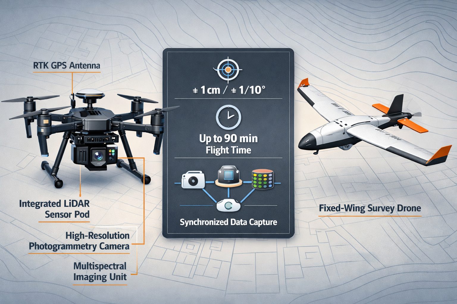
Modern UAV platforms now come in two primary configurations, each optimized for specific surveying applications:
| Platform Type | Best Applications | Key Advantages | Typical Flight Time |
|---|---|---|---|
| Multirotor Drones | Small to medium properties, detailed inspections, vertical structures | Precise hovering, vertical takeoff/landing, excellent maneuverability | 20-45 minutes |
| Fixed-Wing Drones | Large-scale topographic surveys, agricultural land, infrastructure corridors | Extended flight duration, greater area coverage, fuel efficiency | 45-90 minutes |
The strategic deployment of both platforms allows surveying professionals to match the tool precisely to the project requirements.[4] For a detailed homebuyer survey of a residential property, a multirotor drone provides the stability and precision needed for close-range inspection. For large-scale topographic mapping of development sites, fixed-wing platforms deliver the endurance and coverage efficiency that projects demand.
Multi-Sensor Integration: The Game-Changing Advancement
Perhaps the most significant development in Drones in Property Surveying: 2026 Advancements in UAVs, LiDAR, and Photogrammetry is the seamless integration of multiple sensor systems working simultaneously. Modern UAVs now feature synchronized sensor arrays that include:
- High-resolution photogrammetry cameras (42+ megapixels) capturing detailed RGB imagery
- LiDAR sensors emitting millions of laser pulses per second for precise elevation data
- Multispectral imaging units detecting vegetation health and moisture patterns
- Thermal cameras identifying heat signatures and insulation deficiencies
This multi-sensor approach represents a fundamental shift from previous generations of survey drones.[1] What previously required multiple flights with different equipment configurations—or even separate site visits with ground-based instruments—now happens in a single mission. The efficiency gains are extraordinary, reducing project timelines from weeks to days while simultaneously improving data quality and completeness.
Real-Time Kinematic Positioning: Achieving Centimeter Accuracy
Accuracy has always been the cornerstone of professional surveying work. In 2026, RTK (Real-Time Kinematic) and PPK (Post-Processed Kinematic) positioning systems have become standard features on professional survey drones.[2] These technologies work by receiving correction signals from ground-based reference stations or satellite networks, enabling the drone to determine its position with centimeter-level precision during flight.
The practical implications are profound. Survey-grade accuracy means drone-collected data can now be used for:
✅ Legal boundary determinations and property line disputes
✅ Precise volumetric calculations for earthwork and materials estimation
✅ Stock condition surveys requiring accurate measurements
✅ Engineering-grade topographic mapping for development planning
✅ Commercial property valuations requiring detailed site analysis
The accuracy achieved depends on several factors including sensor quality, flight altitude, ground control point distribution, and atmospheric conditions. However, when properly executed, modern drone surveys routinely achieve horizontal accuracy of ±2-3 centimeters and vertical accuracy of ±5-7 centimeters.[4]
LiDAR Technology: Penetrating Beyond Visual Surfaces
Understanding LiDAR Principles in Aerial Surveying
Light Detection and Ranging (LiDAR) technology has revolutionized how surveyors capture three-dimensional property data. Unlike traditional photogrammetry, which relies on visual imagery to calculate distances and elevations, LiDAR uses laser pulses to directly measure the distance between the sensor and ground features.
Here's how the process works:
- The LiDAR sensor emits rapid laser pulses (often 300,000+ per second)
- These pulses bounce off surfaces—buildings, vegetation, terrain—and return to the sensor
- The system calculates distance based on the time elapsed between emission and return
- Combined with precise GPS positioning and inertial measurement data, each return creates a georeferenced 3D point
- Millions of these points form a detailed "point cloud" representing the surveyed area
The revolutionary aspect of LiDAR is its ability to penetrate vegetation canopy. Multiple returns from a single pulse allow the system to capture data from tree tops, mid-canopy vegetation, and ground surface simultaneously. This capability is invaluable for property surveys in wooded or heavily vegetated areas where traditional methods struggle.
LiDAR Applications in Modern Property Surveying
The applications of drone-mounted LiDAR in property surveying extend far beyond basic topographic mapping. In 2026, professionals are deploying this technology for:
Boundary and Easement Identification: LiDAR excels at detecting subtle elevation changes, fence lines, and property markers that might be obscured by vegetation or difficult to access safely. The technology provides comprehensive documentation for specific defect surveys and boundary dispute resolution.
Flood Risk Assessment: Precise elevation models generated from LiDAR data enable accurate flood plain mapping and drainage analysis. This information is critical for property valuations, insurance assessments, and development planning in areas with flood concerns.
Infrastructure Inspection: Power lines, bridges, telecommunications towers, and other vertical infrastructure benefit from LiDAR's ability to capture detailed structural geometry without requiring physical access to dangerous locations.[2]
Volumetric Analysis: Stockpile measurements, cut-and-fill calculations for earthwork, and material quantity estimates achieve new levels of precision with LiDAR-derived volume calculations.
Forest and Vegetation Management: For large estates, agricultural properties, or conservation areas, LiDAR provides detailed canopy height models, biomass estimates, and vegetation density mapping.
Cost-Effectiveness of LiDAR in 2026
A critical factor driving adoption of Drones in Property Surveying: 2026 Advancements in UAVs, LiDAR, and Photogrammetry is the dramatic reduction in LiDAR equipment costs. What once required six-figure investments in specialized aircraft and sensor systems can now be accomplished with drone-mounted LiDAR units available for a fraction of historical costs.
This accessibility has democratized LiDAR surveying. Small to medium-sized surveying firms can now offer services previously available only through major engineering companies or specialized aerial survey contractors. The result is increased competition, improved service delivery, and better value for property owners requiring detailed survey work.
Photogrammetry: High-Resolution Visual Data Capture
The Science Behind Drone Photogrammetry
Photogrammetry—the science of making measurements from photographs—has been transformed by modern drone technology. The principle is elegant: by capturing overlapping images from multiple angles and positions, specialized software can calculate the three-dimensional coordinates of features visible in the photographs.
Modern photogrammetry workflows follow a systematic process:
- Flight Planning: Software calculates optimal flight paths ensuring 70-80% image overlap
- Image Acquisition: High-resolution cameras capture hundreds or thousands of geotagged photos
- Processing: Advanced algorithms identify common features across multiple images
- Point Cloud Generation: Software calculates 3D positions for millions of points
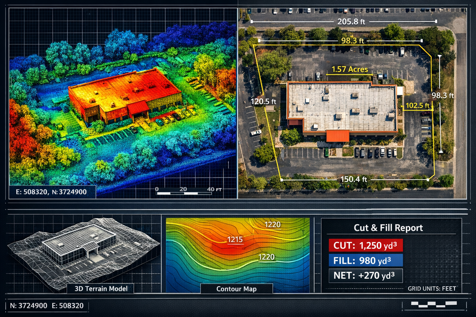
- Model Creation: Point clouds are converted into textured 3D models, orthomosaic maps, or digital elevation models
The quality of photogrammetric outputs depends heavily on image resolution, overlap percentage, lighting conditions, and ground control point accuracy. In 2026, cameras with 42+ megapixel sensors and advanced image stabilization systems deliver exceptional results even in challenging conditions.
Deliverables That Drive Decision-Making
One of the most compelling aspects of drone photogrammetry is the variety of actionable deliverables it produces. These standardized outputs integrate seamlessly with existing workflows and software platforms used by property professionals:[2][3]
Orthomosaic Maps: Geometrically corrected aerial photographs that combine hundreds of individual images into a single, accurate map. Unlike perspective photographs, orthomosaics maintain consistent scale throughout, making them suitable for precise measurements and property certification work.
3D Terrain Models: Digital representations of ground surface elevations that enable slope analysis, drainage planning, and visual site assessment from any angle.
Point Cloud Data: Dense collections of georeferenced 3D points that can be imported into CAD, BIM (Building Information Modeling), and GIS (Geographic Information Systems) platforms for detailed analysis and design work.
Contour Maps: Traditional topographic representations showing elevation changes through contour lines, essential for engineering design and planning applications.
Cut/Fill Calculations: Precise volumetric comparisons between existing and proposed ground surfaces, critical for earthwork estimation and project budgeting.
These deliverables support a wide range of property surveying applications, from structural surveys requiring detailed building measurements to dilapidation surveys documenting property conditions.
Photogrammetry vs. LiDAR: Complementary Technologies
A common question in 2026 is whether photogrammetry or LiDAR provides superior results. The answer is nuanced: both technologies offer distinct advantages, and many modern survey drones integrate both sensors to leverage their complementary strengths.
Photogrammetry Advantages:
- 📸 Captures true-color imagery with rich visual detail
- 💰 Generally lower equipment costs
- 🎨 Produces textured 3D models ideal for visualization
- ☀️ Excellent performance in open, well-lit areas
LiDAR Advantages:
- 🌲 Penetrates vegetation to capture ground surface
- 🌙 Functions effectively in low-light conditions
- 📏 Delivers consistent accuracy regardless of surface texture
- ⚡ Faster data acquisition for large areas
For comprehensive property surveys, the integration of both technologies provides the most complete dataset. Photogrammetry delivers visual context and detailed surface textures, while LiDAR ensures accurate ground elevation data even in vegetated or shadowed areas.[1]
Speed, Safety, and Efficiency: Transforming Survey Workflows
Dramatic Time Savings in Data Collection
The efficiency improvements delivered by Drones in Property Surveying: 2026 Advancements in UAVs, LiDAR, and Photogrammetry cannot be overstated. Traditional ground-based surveying methods require surveyors to physically access every measurement point, a time-intensive process complicated by terrain, vegetation, and property access constraints.
Drone surveys achieve remarkable speed advantages:
- Areas requiring days or weeks with traditional methods are completed in hours with drones[3]
- A single flight can capture thousands of detailed data points simultaneously
- What previously demanded multiple site visits now happens in single missions[1]
Consider a practical example: surveying a 50-acre development site with traditional total station equipment might require a crew of 2-3 surveyors working for 5-7 days. The same site can be comprehensively surveyed with a drone in 2-3 hours of flight time, with data processing completed within 24-48 hours. The time savings translate directly to reduced costs and faster project delivery.
Enhanced Safety Through Remote Data Collection
Safety represents one of the most compelling advantages of drone-based surveying. Traditional methods frequently require surveyors to work in hazardous conditions:
- ⚠️ Near high-speed traffic on roadway projects
- ⚠️ On unstable slopes or cliff edges
- ⚠️ In contaminated or environmentally sensitive areas
- ⚠️ Around active construction sites with heavy equipment
- ⚠️ On rooftops or elevated structures
Drones eliminate these risks by enabling remote data collection from safe distances.[2] Surveyors operate from secure locations while the UAV captures comprehensive data from challenging or dangerous areas. This safety improvement is particularly valuable for commercial building surveys involving large industrial facilities or complex infrastructure.
The safety benefits extend beyond personnel protection. Reduced ground presence minimizes disruption to ongoing operations, decreases liability exposure, and eliminates the need for traffic control or extensive safety equipment in many scenarios.
Complete Coverage Without Data Gaps
Traditional surveying methods inherently involve sampling—measuring specific points and interpolating between them. This approach can miss important features or create gaps in data coverage, particularly in complex terrain or areas with access restrictions.
Drone surveys provide continuous coverage across entire project areas.[2] Rather than sampling discrete points, the UAV captures data from every square meter of the surveyed area. This comprehensive approach offers several advantages:
✅ No missed features: Subtle elevation changes, drainage patterns, or boundary markers are captured in the complete dataset
✅ Improved reliability: Continuous data reduces uncertainty and interpolation errors
✅ Better documentation: Complete coverage provides thorough records for expert witness reports or dispute resolution
✅ Enhanced analysis: Dense data enables sophisticated modeling and predictive analysis
For complex properties or challenging terrain, this complete coverage capability represents a fundamental improvement over traditional sampling-based methods.
Autonomous Operations and AI Integration
Predictive Flight Planning and Optimization
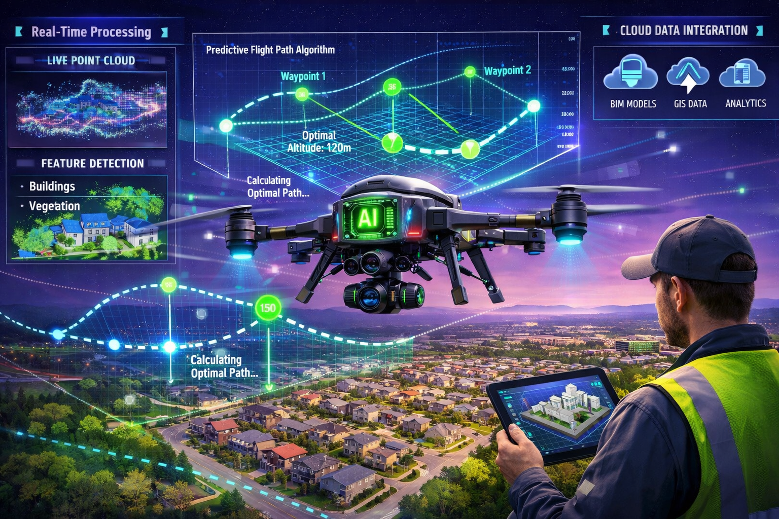
The advancement of autonomous capabilities represents a defining characteristic of drone surveying in 2026. Modern systems employ predictive modeling to plan optimal flight paths without requiring constant operator intervention.[1]
Intelligent flight planning systems analyze project requirements and automatically determine:
- Optimal flight altitude balancing coverage efficiency with required resolution
- Camera angle and orientation for maximum overlap and feature visibility
- Sensor selection and settings appropriate for lighting and terrain conditions
- Waypoint spacing ensuring complete coverage with minimal redundancy
- Battery management including automatic return-to-home for battery changes on large projects
This automation dramatically reduces the expertise required for effective drone operation. While skilled pilots remain valuable for complex scenarios, standardized survey missions can now be executed by property professionals with basic UAV training.
Real-Time Data Processing and Analysis
Perhaps the most exciting development in 2026 is the emergence of real-time data processing capabilities. Traditional workflows required completing fieldwork, returning to the office, and spending hours or days processing data before results became available. Modern systems are changing this paradigm.[2]
Real-time processing enables:
- Immediate verification of data quality while still on-site
- Rapid identification of areas requiring additional coverage
- Preliminary measurements and analysis during the survey mission
- Same-day delivery of basic deliverables to clients
- Faster decision-making for time-sensitive projects
Cloud-based processing platforms contribute significantly to these speed improvements. Rather than relying solely on local workstation processing, survey data can be uploaded to powerful cloud servers that process point clouds and generate deliverables in a fraction of the time required by traditional methods.[2]
AI-Powered Feature Detection and Classification
Artificial intelligence is transforming how survey data is analyzed and interpreted. AI algorithms can automatically identify and classify features within point cloud and photogrammetric data:
🏠 Building Detection: Automatic identification and measurement of structures
🌳 Vegetation Classification: Distinguishing trees, shrubs, and ground cover
🚗 Infrastructure Recognition: Identifying roads, utilities, and built features
📏 Boundary Extraction: Detecting fence lines, walls, and property demarcations
⚡ Change Detection: Comparing surveys over time to identify modifications
These capabilities reduce manual processing time and improve consistency in feature classification. For large-scale projects or portfolio management involving multiple properties, AI-powered analysis delivers significant efficiency gains.
Industry Applications and Market Growth
Expanding Use Cases Across Property Sectors
The versatility of Drones in Property Surveying: 2026 Advancements in UAVs, LiDAR, and Photogrammetry has driven adoption across diverse property and land management sectors. In 2026, applications extend far beyond traditional topographic surveying:
Residential Property Assessment: Detailed roof inspections, property boundary verification, and site analysis for valuation purposes without requiring physical roof access.
Commercial Real Estate: Comprehensive site surveys for development feasibility, tenant improvement planning, and portfolio asset management.
Infrastructure Monitoring: Regular inspection of bridges, roads, railways, and utility corridors to identify maintenance needs and track deterioration over time.[5]
Environmental Management: Coastal erosion tracking, wetland monitoring, forest health assessment, and habitat mapping for conservation and regulatory compliance.[5]
Construction Progress Tracking: Regular surveys documenting construction progress, verifying earthwork quantities, and ensuring compliance with approved plans.
Agricultural Land Management: Crop health monitoring, irrigation system planning, drainage analysis, and precision agriculture applications.
Utility and Energy: Power line inspection, solar farm planning, wind turbine assessment, and pipeline corridor monitoring.
The breadth of applications reflects the fundamental value proposition: affordable access to accurate spatial data that previously required expensive specialized services or extensive manual fieldwork.
Market Growth Projections and Industry Trends
The drone mapping market is experiencing explosive growth, with projections indicating the market will exceed $6.5 billion by 2026.[9] This expansion reflects several converging trends:
📈 Decreasing equipment costs making professional-grade systems accessible to smaller firms
📈 Regulatory maturation providing clear operational frameworks in most jurisdictions
📈 Improved software platforms simplifying data processing and analysis
📈 Growing awareness among property professionals of drone survey capabilities
📈 Integration with existing workflows through standardized data formats and deliverables
Government agencies, utilities, engineering firms, and environmental organizations are increasingly deploying drones for advanced monitoring and assessment applications.[5] This institutional adoption signals the technology's transition from innovative tool to standard practice.
Integration with Traditional Surveying Services
An important consideration for 2026 is how drone technology complements rather than replaces traditional surveying methods. Professional surveyors integrate UAV capabilities into comprehensive service offerings that may include:
- Ground-based total station surveys for precise control networks
- GNSS/GPS measurements for geodetic control
- Structural engineering assessments requiring physical inspection
- Boundary determinations requiring legal research and monumentation
- Building interior surveys where drone access is impractical
The most effective surveying practices in 2026 leverage the strengths of multiple technologies, deploying drones where they offer clear advantages while maintaining traditional methods where they remain superior. This integrated approach delivers optimal results for clients requiring comprehensive property assessment.
Challenges and Considerations
Regulatory Compliance and Operational Limitations
While drone technology has matured significantly, operators must navigate regulatory frameworks that vary by jurisdiction. In 2026, most developed countries have established clear rules for commercial drone operations, typically including:
- Pilot certification requirements
- Operational altitude restrictions (commonly 400 feet/120 meters)
- Line-of-sight operation mandates
- Restricted airspace limitations near airports and sensitive areas
- Privacy and data protection compliance
Weather conditions also impose operational constraints. High winds, precipitation, and extreme temperatures can prevent safe flight operations or compromise data quality. Professional survey planning must account for these limitations and maintain schedule flexibility.
Data Management and Processing Requirements
The richness of drone-collected data creates substantial data management challenges. A single survey mission might generate:
- 500-2,000 high-resolution photographs (50+ GB)
- Point cloud data with millions of georeferenced points (10-100 GB)
- LiDAR returns with multiple classifications (20-200 GB)
- Metadata, flight logs, and calibration information
Processing these datasets requires powerful computing resources and specialized software. While cloud-based processing has improved accessibility, professionals must invest in robust data management systems, backup protocols, and long-term archival solutions.
Skill Development and Training Investment
Effective deployment of Drones in Property Surveying: 2026 Advancements in UAVs, LiDAR, and Photogrammetry requires investment in skill development. Property professionals must acquire competencies in:
✓ UAV operation and flight planning
✓ Sensor selection and configuration
✓ Data processing software operation
✓ Quality control and accuracy verification
✓ Integration with CAD/BIM/GIS platforms
✓ Deliverable preparation and presentation
While automation has reduced the learning curve, achieving professional-grade results still demands training and experience. Many surveying firms address this through dedicated UAV specialists or partnerships with drone service providers.
Future Developments and Emerging Technologies
Advanced Sensor Integration
Looking beyond 2026, the trajectory of drone surveying points toward even more sophisticated multi-sensor integration. Emerging developments include:
Hyperspectral Imaging: Beyond standard multispectral sensors, hyperspectral systems capture hundreds of narrow spectral bands, enabling advanced material identification and condition assessment.
Ground-Penetrating Radar: Experimental drone-mounted GPR systems may enable subsurface utility detection and archaeological investigation from aerial platforms.
Gas Detection Sensors: Environmental monitoring applications will benefit from sensors detecting methane, carbon dioxide, and other gases for leak detection and emissions monitoring.
Advanced Thermal Systems: Higher-resolution thermal cameras with radiometric capabilities will improve building energy audits and moisture detection.
Fully Autonomous Survey Operations
The evolution toward complete autonomy continues, with future systems expected to:
- Execute complex multi-day survey campaigns with minimal human oversight
- Automatically identify and respond to changing conditions
- Self-optimize flight parameters based on real-time data quality assessment
- Coordinate multiple drones for simultaneous large-area coverage
- Integrate with robotic ground-based systems for comprehensive site documentation
These capabilities will further reduce operational costs while improving consistency and reliability.
Enhanced AI and Machine Learning Applications
Artificial intelligence will play an increasingly central role in extracting value from survey data:
- Predictive maintenance algorithms identifying structural issues before failure
- Automated compliance checking against building codes and regulations
- Historical change detection tracking property modifications over time
- Intelligent feature extraction reducing manual digitization requirements
- Natural language interfaces allowing non-technical users to query survey data
These developments will democratize access to sophisticated analysis capabilities, enabling property professionals without specialized technical training to leverage advanced survey data effectively.
Implementing Drone Surveying in Your Practice
Evaluating the Business Case
For property professionals considering adoption of drone surveying capabilities, a thorough business case evaluation should consider:
Cost Analysis:
- Equipment investment (drone, sensors, processing software)
- Training and certification expenses
- Insurance and regulatory compliance costs
- Ongoing maintenance and equipment updates
- Opportunity costs of internal development versus outsourcing
Revenue Opportunities:
- New service offerings to existing clients
- Expanded market reach to clients requiring specialized capabilities
- Faster project delivery enabling higher throughput
- Competitive differentiation in crowded markets
- Premium pricing for advanced deliverables
Risk Considerations:
- Technology obsolescence and upgrade cycles
- Regulatory changes affecting operations
- Weather and operational limitations
- Data security and privacy liability
- Equipment damage or loss
Many firms find that partnership models offer optimal risk-reward profiles, collaborating with specialized drone service providers rather than developing full in-house capabilities initially.
Selecting Appropriate Equipment and Services
The drone surveying market offers numerous equipment options across wide price ranges. Selection criteria should include:
Platform Selection:
- Project size and typical coverage requirements
- Terrain characteristics (flat, hilly, vegetated)
- Portability and transportation needs
- Flight time and battery logistics
- Weather resistance and operational envelope
Sensor Configuration:
- Required accuracy levels for typical projects
- Importance of vegetation penetration (LiDAR)
- Need for visual documentation (photogrammetry)
- Specialized requirements (thermal, multispectral)
- Budget constraints and cost-effectiveness
Software Ecosystem:
- Compatibility with existing CAD/BIM/GIS platforms
- Processing speed and hardware requirements
- Learning curve and training availability
- Support and update policies
- Licensing models (perpetual vs. subscription)
For firms requiring drone survey data but not ready to invest in equipment and training, professional drone survey services offer turnkey solutions. When selecting service providers, evaluate their experience with similar projects, equipment capabilities, turnaround times, and deliverable formats.
Quality Assurance and Best Practices
Maintaining high standards in drone surveying requires robust quality assurance protocols:
Pre-Flight Planning:
- Site reconnaissance and hazard identification
- Ground control point placement and survey
- Flight plan optimization and approval
- Weather assessment and contingency planning
- Regulatory compliance verification
Data Collection:
- Systematic flight execution following approved plans
- Real-time data quality monitoring
- Redundant coverage of critical areas
- Proper sensor calibration and settings
- Comprehensive metadata documentation
Post-Processing:
- Accuracy verification against ground control
- Completeness checking for data gaps
- Coordinate system and datum confirmation
- Deliverable format standardization
- Quality control review before client delivery
Documentation:
- Comprehensive project records and metadata
- Processing parameters and settings
- Accuracy statements and limitations
- Archival of raw data for future reference
- Client communication and deliverable explanation
These practices ensure consistent, reliable results that meet professional standards and client expectations.
Conclusion
Drones in Property Surveying: 2026 Advancements in UAVs, LiDAR, and Photogrammetry represent far more than incremental improvements to existing methods—they constitute a fundamental transformation in how spatial data is captured, analyzed, and applied to property assessment and management. The convergence of affordable hardware, sophisticated sensors, powerful processing capabilities, and intelligent automation has democratized access to survey-grade data that was previously available only through expensive specialized services.
The benefits are clear and compelling:
✅ Dramatic efficiency improvements reducing survey timelines from weeks to hours
✅ Centimeter-level accuracy suitable for professional property work and legal applications
✅ Enhanced safety eliminating hazardous ground-based data collection
✅ Complete coverage without the gaps inherent in traditional sampling methods
✅ Rich deliverables integrating seamlessly with modern design and analysis platforms
✅ Cost accessibility enabling smaller firms to offer sophisticated services
For property professionals—whether conducting homebuyer surveys, commercial property valuations, or comprehensive structural assessments—drone technology offers capabilities that were unimaginable just a few years ago.
Actionable Next Steps
For Property Professionals New to Drone Surveying:
- Educate yourself on drone capabilities and limitations through industry resources and case studies
- Assess your needs by identifying projects where drone data would deliver clear value
- Explore partnerships with established drone service providers to test capabilities on pilot projects
- Evaluate ROI based on actual project experience before committing to equipment investment
- Develop expertise through training programs if in-house capabilities align with business strategy
For Firms with Existing Drone Capabilities:
- Upgrade sensors to take advantage of latest LiDAR and photogrammetry advancements
- Implement automation to improve efficiency and reduce operator skill requirements
- Expand applications beyond basic topographic mapping to specialized services
- Enhance processing with AI-powered analysis and real-time capabilities
- Standardize workflows ensuring consistent quality across all projects
For Property Owners and Developers:
- Request drone surveys when commissioning property assessments or site analysis
- Specify deliverables that integrate with your existing design and planning workflows
- Verify credentials ensuring service providers have appropriate certifications and insurance
- Leverage data for multiple purposes beyond the initial survey objective
- Archive datasets for future reference and change detection analysis
The drone surveying revolution is not coming—it has arrived. In 2026, the question is no longer whether to adopt this technology, but how to implement it most effectively to deliver superior results, improved efficiency, and enhanced value to clients. Property professionals who embrace these advancements position themselves at the forefront of an industry undergoing its most significant transformation in generations.
The future of property surveying is aerial, autonomous, and data-rich. The tools are available, the technology is proven, and the benefits are undeniable. The time to act is now.
References
[1] Future Land Surveying 2026 – https://haller-blanchard.com/future-land-surveying-2026/
[2] The Impact Of Drone Technology On Digital Land Survey And Data Collection Workflows – https://www.companionlink.com/blog/2026/01/the-impact-of-drone-technology-on-digital-land-survey-and-data-collection-workflows/
[3] Drone Surveying – https://uavcoach.com/drone-surveying/
[4] Advancing Surveying With Drone Technology – https://www.unmannedsystemstechnology.com/feature/advancing-surveying-with-drone-technology/
[5] Mapping The Future Critical Geospatial Trends For 2026 – https://woolpert.com/mapping-the-future-critical-geospatial-trends-for-2026/
[9] Aerial Survey Companies – https://www.extremeaerialproductions.com/post/aerial-survey-companies