The property surveying industry stands at a technological crossroads in 2026, where affordable drone technology meets sophisticated data capture capabilities. What once required weeks of manual fieldwork, expensive equipment, and teams of surveyors can now be accomplished in hours with unmanned aerial vehicles (UAVs) equipped with high-resolution cameras and LiDAR sensors. The transformation isn't just about speed—it's about accessibility, accuracy, and safety. Drones in Property Surveying: 2026 Advancements in UAV Photogrammetry and LiDAR represent a fundamental shift in how professionals assess, measure, and document properties across residential, commercial, and large-scale development projects.
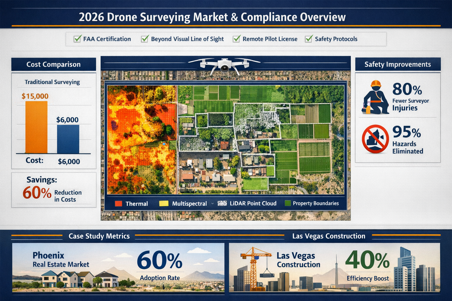
As costs continue to decline and regulatory frameworks mature, drone surveying has moved from specialized applications to mainstream adoption. Real estate agents in Phoenix now incorporate drone media in 60 percent of their listings, while construction firms in Las Vegas have cut field time in half using UAV-enabled surveys.[3] This democratization of advanced surveying technology means that even small surveying firms can now compete with larger operations, delivering centimeter-level accuracy without the traditional overhead costs.
Key Takeaways
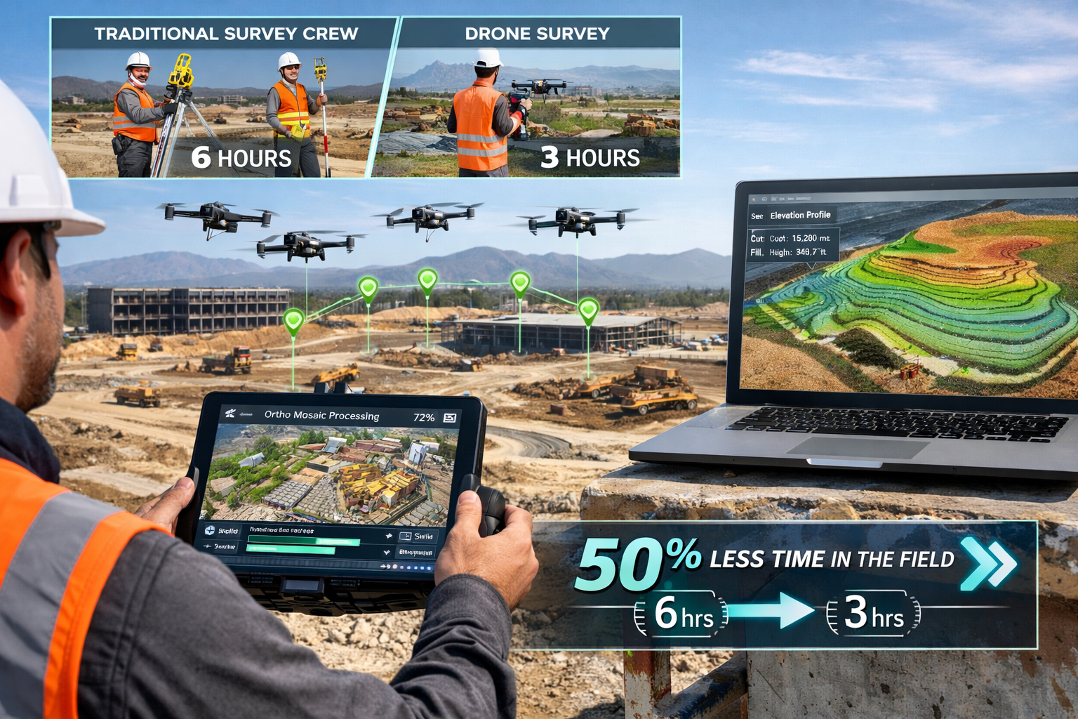
✅ Dramatic efficiency gains: Drone surveys complete in hours what traditional methods accomplish in days or weeks, with construction projects experiencing 50% reductions in field time.[2][3]
✅ Cost-effective accuracy: Modern UAV platforms deliver centimeter-level precision at significantly lower operational costs than conventional ground-based surveying methods.[2][4]
✅ Dual technology advantage: Photogrammetry excels at creating detailed visual models while LiDAR penetrates vegetation and captures terrain beneath tree canopy, providing complementary data sets.[2]
✅ Enhanced safety protocols: Aerial data capture eliminates surveyor exposure to hazardous terrain, busy roadways, and dangerous environments, reducing workplace injuries.[2]
✅ Real-time data integration: Advanced GIS connectivity enables immediate processing of drone-captured data into actionable intelligence including orthomosaics, 3D models, and thermal imagery.[4]
Understanding the Technology Behind Drones in Property Surveying: 2026 Advancements in UAV Photogrammetry and LiDAR
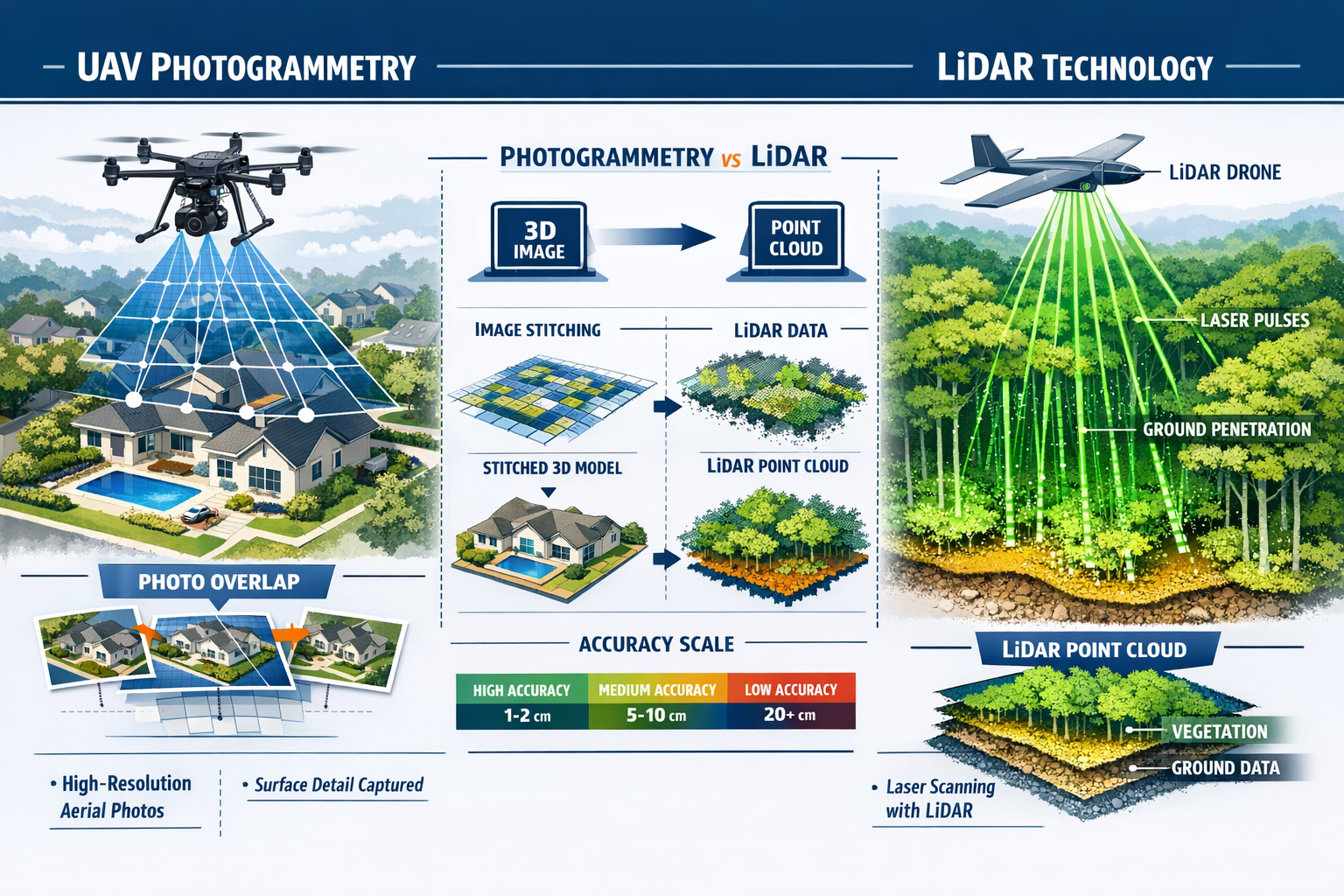
What Is UAV Photogrammetry?
Photogrammetry represents the science of making measurements from photographs. When applied to drone surveying, UAVs capture hundreds or thousands of overlapping aerial images from multiple angles and altitudes. Sophisticated software then processes these images through a technique called "structure from motion" to create comprehensive 2D and 3D representations of the surveyed area.
The process works by identifying common points across multiple photographs, calculating their positions in three-dimensional space, and stitching together a seamless model. Modern drone surveys produce sharp orthomosaics—geometrically corrected aerial images where every pixel represents true ground position—and intricate 3D representations that enable identification of features like signage, curbs, road indicators, hydrants, and drainage systems.[2]
When equipped with high-resolution cameras, drones deliver centimeter-level accuracy for distance measurements and positional relationships in both 2D and 3D space. The actual precision depends on several factors including sensor quality, flight altitude, ground control point placement, and atmospheric conditions.[4]
How LiDAR Technology Revolutionizes Terrain Mapping
LiDAR (Light Detection and Ranging) sensors use laser light to measure distances to Earth's surface with remarkable precision. Unlike photogrammetry which relies on visible light and camera optics, LiDAR actively emits laser pulses—often hundreds of thousands per second—and measures the time it takes for each pulse to return after bouncing off surfaces below.
The revolutionary advantage of LiDAR lies in its ability to penetrate dense vegetation to produce highly accurate 3D models of the ground surface beneath tree canopy. This capability has helped archaeologists discover new archaeological sites hidden under jungle growth and provides fast, reliable ways to create 3D maps of difficult terrain that would be impossible to survey using traditional methods or photogrammetry alone.[2]
In property surveying applications, LiDAR excels at:
- 🌳 Vegetation penetration: Capturing ground elevation data beneath trees and shrubs
- 🏗️ Structural analysis: Measuring building heights and architectural features with millimeter precision
- 📊 Volumetric calculations: Determining stockpile volumes, earthwork quantities, and cut-fill analysis
- 🌍 Terrain modeling: Creating detailed digital elevation models (DEMs) and digital terrain models (DTMs)
- 🔍 Infrastructure inspection: Identifying structural deformations and settlement issues
Comparing Photogrammetry and LiDAR Capabilities
| Feature | Photogrammetry | LiDAR |
|---|---|---|
| Data Type | RGB imagery, visual detail | Point cloud, elevation data |
| Vegetation Penetration | Limited to visible surfaces | Penetrates to ground level |
| Accuracy | 1-5 cm (optimal conditions) | 1-3 cm (consistent) |
| Cost | Lower initial investment | Higher equipment costs |
| Processing Time | Moderate (image stitching) | Faster (direct measurements) |
| Best Applications | Visual documentation, orthomosaics | Terrain modeling, forestry |
| Weather Sensitivity | Requires good lighting | Works in various conditions |
Many surveying professionals in 2026 employ hybrid approaches, using both technologies on the same project to leverage their complementary strengths. This combination provides rich visual context from photogrammetry alongside precise elevation data from LiDAR, creating comprehensive survey deliverables that satisfy diverse client requirements.
Efficiency and Cost Benefits Transforming Property Surveying in 2026
Time Savings That Reshape Project Timelines
The most immediately apparent advantage of drone surveying is the dramatic reduction in field time. Traditional ground-based surveying of large areas might require days or even weeks of manual effort, with teams of surveyors traversing difficult terrain with total stations, GPS receivers, and measuring equipment. Drones can cover the same ground in a matter of hours, fundamentally reshaping project timelines and resource allocation.[2]
Real-world data from 2026 demonstrates these efficiency gains across multiple sectors:
Construction Industry: Major construction builds in Las Vegas and Phoenix have experienced 50 percent reductions in field time since 2025 through drone-enabled surveys. Applications include pre-site mapping, volumetric analysis for earthwork planning, progress monitoring throughout construction phases, and ongoing safety audits.[3]
Energy Sector: A Nevada solar farm cut inspection time by 80 percent using drones equipped with thermal imaging in 2024. By 2025, Nevada's solar plants routinely use thermal inspections to detect panel faults quickly, reducing downtime by 30 percent according to industry data.[3]
Real Estate Market: The acceleration in sales cycles represents another time-related benefit. Real estate agents using 360-degree VR tours and cinematic fly-throughs created from drone data give buyers a true sense of property scale and context, dramatically speeding up decision-making processes.[3]
For professionals conducting property inspections, the ability to capture comprehensive site data in a single visit—rather than multiple return trips—represents significant scheduling efficiency.
Lower Operational Costs Without Compromising Quality
While the initial investment in drone technology can be substantial—ranging from several thousand pounds for entry-level professional systems to tens of thousands for advanced LiDAR-equipped platforms—operational costs for drone surveying are significantly lower than traditional methods because the same work can be completed with fewer people and less equipment.[2]
Consider the cost structure comparison:
Traditional Surveying Costs:
- Multiple surveyors (2-4 personnel)
- Extended field time (days to weeks)
- Transportation and accommodation for remote sites
- Equipment rental or depreciation
- Safety equipment and insurance
- Access arrangements for difficult terrain
Drone Surveying Costs:
- Single operator (potentially with assistant)
- Minimal field time (hours)
- Reduced travel requirements
- Lower insurance premiums
- Decreased safety incident exposure
- Minimal site access requirements
The economic equation becomes particularly favorable for large-area surveys, repeat monitoring applications, and sites with challenging access conditions. Organizations conducting regular stock condition surveys across property portfolios can achieve substantial cost savings through systematic drone deployment.
Enhanced Safety Reducing Risk and Liability
Beyond time and money, drone surveying delivers critical safety benefits by eliminating risks associated with traditional surveying methods. Capturing data from the air reduces or eliminates the need for surveyors to navigate challenging terrain, busy roads, unstable structures, or hazardous environments, thereby reducing potential on-site injuries.[2]
Specific safety improvements include:
🛡️ Eliminated fall risks: No need to access rooftops, steep slopes, or unstable ground
🚧 Reduced traffic exposure: Highway and infrastructure surveys conducted without lane closures
⚠️ Hazardous site monitoring: Chemical plants, mining operations, and contaminated sites surveyed remotely
🏚️ Structural safety: Damaged or unstable buildings assessed without human entry
The safety advantages extend to structural surveys and roof surveys, where drone inspection can identify potential issues without requiring surveyors to physically access potentially dangerous structures.
Autonomous Systems and Real-Time Data Processing Capabilities
Drone Swarms and Coordinated Autonomous Operations
One of the most significant advancements in Drones in Property Surveying: 2026 Advancements in UAV Photogrammetry and LiDAR involves the development of autonomous drone systems capable of operating in coordinated swarms. These systems work together efficiently, collecting data with minimal human intervention through precise, coordinated flight paths that increase both the speed and accuracy of surveying tasks.[1]
Autonomous drone swarms offer particular advantages for:
- Large-scale projects: Multiple drones simultaneously survey different sections of extensive sites
- Hard-to-reach areas: Coordinated approach from multiple angles captures complete coverage
- Time-critical applications: Parallel data collection dramatically reduces total survey duration
- Consistency: Automated flight paths eliminate human variability between survey sessions
The technology relies on sophisticated mission planning software that divides survey areas into optimal flight zones, calculates efficient flight paths accounting for terrain elevation, establishes waypoint navigation with centimeter precision, and coordinates multiple aircraft to avoid conflicts while maximizing coverage.
In 2026, autonomous capabilities have matured to the point where surveyors can pre-program entire missions, deploy drones, and focus on quality control and data validation rather than manual flight operations. This evolution transforms the surveyor's role from equipment operator to data analyst and quality assurance specialist.
GIS Integration Enabling Real-Time Intelligence
Advanced integration with Geographic Information Systems (GIS) represents another transformative capability in 2026. Modern drone surveying workflows allow captured data to be processed to produce actionable intelligence in near real time, with outputs including orthomosaic maps, 3D models, LiDAR point clouds, thermal imagery, and multispectral datasets.[4]
This integration creates several practical advantages:
Immediate Quality Verification: Surveyors can review processed data while still on-site, identifying coverage gaps or quality issues that require additional flight passes before demobilizing equipment.
Rapid Decision-Making: Construction managers, developers, and planners can access preliminary survey results within hours rather than waiting days or weeks for traditional survey deliverables.
Continuous Monitoring: Projects requiring regular updates—such as construction progress tracking or erosion monitoring—benefit from standardized, repeatable workflows that enable direct comparison between survey sessions.
Multi-Layered Analysis: GIS platforms combine drone-captured data with existing survey information, utility records, planning constraints, and environmental data to create comprehensive analytical environments.
For professionals conducting building surveys or homebuyer surveys, the ability to integrate drone-captured roof and site data with detailed interior inspection findings creates more comprehensive assessment documentation.
Platform Selection: Fixed-Wing vs. Multirotor Systems
The choice between fixed-wing and multirotor drones significantly impacts survey capabilities and efficiency. Both platforms have established roles in property surveying, with selection depending on project requirements.[4]
Fixed-Wing Platforms:
- ✈️ Longer flight endurance (45-90 minutes typical)
- 📏 Large-area coverage (hundreds of acres per flight)
- 💨 Higher flight speeds
- ⚡ Greater efficiency for linear infrastructure
- ❌ Require launch/recovery space
- ❌ Less maneuverable in confined areas
Multirotor Platforms:
- 🚁 Vertical takeoff and landing (VTOL)
- 🎯 Precise positioning and hovering capability
- 🏘️ Ideal for confined urban environments
- 📸 Superior for detailed structural inspection
- ⏱️ Shorter flight times (20-35 minutes typical)
- 📐 Better for smaller, complex sites
In 2026, hybrid VTOL platforms have emerged that combine fixed-wing efficiency for transit and coverage with multirotor precision for detailed inspection, offering versatile solutions for diverse surveying requirements. These systems are particularly valuable for projects requiring both broad-area mapping and detailed structural documentation.
Regulatory Framework and Professional Standards in 2026
Aviation Authority Requirements and Compliance
The regulatory environment governing drone operations has matured significantly by 2026, with most jurisdictions implementing risk-based frameworks that balance innovation with safety. Understanding and complying with these regulations represents a fundamental requirement for professional surveying operations.
Key regulatory considerations include:
📋 Operator Certification: Professional drone pilots must hold appropriate licenses demonstrating aeronautical knowledge, flight proficiency, and understanding of operational regulations.
🛩️ Aircraft Registration: Commercial drone platforms require registration with aviation authorities, with identification markings clearly displayed.
📍 Operational Limitations: Restrictions on flight altitude (typically 400 feet maximum), distance from airports, flights over people, beyond visual line of sight (BVLOS) operations, and urban area operations.
🔒 Privacy and Data Protection: Compliance with data protection regulations when capturing imagery that may include identifiable individuals or private property.
📄 Insurance Requirements: Professional indemnity and public liability coverage specific to drone operations.
Many surveying firms have established dedicated compliance officers or utilize specialized software that integrates airspace restrictions, no-fly zones, and temporary flight restrictions into mission planning workflows, ensuring regulatory compliance is verified before every flight.
Professional Accreditation and Quality Standards
As drone surveying has transitioned from novel technology to established practice, professional bodies have developed specific standards and accreditation programs. Organizations like the Royal Institution of Chartered Surveyors (RICS) have integrated UAV capabilities into their competency frameworks for property professionals.
Professional standards address:
- Data accuracy specifications: Defining acceptable tolerances for different survey types
- Quality assurance protocols: Establishing verification and validation procedures
- Deliverable formats: Standardizing outputs for consistency across the industry
- Ethical considerations: Addressing privacy, trespass, and professional conduct issues
- Continuing professional development: Ensuring practitioners maintain current knowledge
When commissioning drone surveys, property owners and developers should verify that providers hold appropriate professional accreditations and follow established quality standards. This is particularly important for surveys supporting legal purposes, such as RICS valuations or expert witness reports.
Data Security and Client Confidentiality
The digital nature of drone surveying creates unique data security considerations. Survey data often contains sensitive information about property layouts, security systems, valuable assets, and commercial operations. Professional surveying firms in 2026 implement robust cybersecurity measures including:
- 🔐 Encrypted data transmission and storage
- 🗄️ Secure cloud platforms with access controls
- 📱 Device security protocols for tablets and controllers
- 🔄 Regular backup procedures
- 🗑️ Secure data disposal after project completion
- 📋 Clear data retention policies
These measures protect client confidentiality while ensuring survey data integrity throughout the project lifecycle.
Case Studies: Real-World Applications and Results
Residential Development Site Analysis
A major residential development in the Home Counties required comprehensive topographic surveying of a 50-acre site with mixed woodland and open fields. Traditional surveying would have required approximately two weeks of fieldwork with a team of three surveyors.
Drone Survey Approach:
- Platform: Hybrid VTOL with photogrammetry and LiDAR
- Flight time: 4 hours across two sessions
- Ground control points: 12 strategically positioned
- Data processing: 24 hours
Results:
- ✅ Total project time reduced from 14 days to 3 days
- ✅ Cost savings of approximately 60%
- ✅ Delivered 2cm accuracy digital elevation model
- ✅ Complete 3D model showing existing structures and vegetation
- ✅ Orthomosaic enabling precise boundary determination
The comprehensive data enabled architects and engineers to begin design work immediately, accelerating the overall development timeline by several weeks. This type of efficiency is increasingly expected for projects requiring comparing different types of survey approaches.
Commercial Property Condition Assessment
A property investment firm required condition assessments of roof structures across a portfolio of 15 commercial properties scattered across multiple locations. Traditional roof access would have required scaffolding, cherry pickers, or rope access specialists at significant cost and safety risk.
Drone Survey Approach:
- Platform: Multirotor with high-resolution camera and thermal imaging
- Survey time per property: 30-45 minutes
- Total fieldwork: 3 days
- Thermal analysis for moisture detection
Results:
- ✅ Identified previously undetected water ingress in 4 properties
- ✅ Documented roof condition with millimeter-resolution imagery
- ✅ Created permanent baseline record for future comparison
- ✅ Zero safety incidents or access-related delays
- ✅ Cost reduction of 75% compared to traditional inspection methods
The thermal imaging capability proved particularly valuable, identifying moisture accumulation invisible to visual inspection alone. This comprehensive approach mirrors the detailed analysis provided in specific defect surveys.
Infrastructure Corridor Mapping
A utility company required detailed surveying of a 12-kilometer corridor for proposed underground cable installation, crossing varied terrain including agricultural land, woodland, and urban areas.
Drone Survey Approach:
- Platform: Fixed-wing with LiDAR and photogrammetry
- Flight time: 6 hours across three days
- Point density: 200 points per square meter
- Corridor width: 100 meters
Results:
- ✅ Complete corridor mapping in one week versus estimated 6 weeks traditionally
- ✅ Vegetation penetration revealed ground conditions beneath tree canopy
- ✅ Identified potential conflicts with existing underground services
- ✅ Enabled precise route optimization reducing construction costs by estimated £200,000
- ✅ Minimal disruption to landowners and traffic
The LiDAR data provided crucial elevation information for gradient analysis, while photogrammetry delivered visual context for stakeholder communication and planning applications.
Future Developments and Emerging Capabilities
Artificial Intelligence and Machine Learning Integration
The next frontier in Drones in Property Surveying: 2026 Advancements in UAV Photogrammetry and LiDAR involves integrating artificial intelligence (AI) and machine learning algorithms directly into surveying workflows. These technologies are already beginning to transform how survey data is processed, analyzed, and interpreted.
Emerging AI applications include:
🤖 Automated feature extraction: AI algorithms identify and classify objects within survey data—buildings, vegetation, vehicles, infrastructure—without manual digitization.
🔍 Defect detection: Machine learning models trained on thousands of images can identify structural defects, material deterioration, and maintenance issues automatically.
📊 Change detection: Comparing survey data across time periods to automatically highlight modifications, construction progress, or environmental changes.
🎯 Quality control: AI-powered validation checks identify data gaps, accuracy issues, or processing errors before final deliverable generation.
These capabilities will increasingly enable surveyors to focus on interpretation and client consultation rather than manual data processing, further improving efficiency and value delivery.
Enhanced Sensor Technologies
Sensor technology continues to advance rapidly, with several developments poised to expand drone surveying capabilities:
Hyperspectral Imaging: Beyond standard RGB and multispectral sensors, hyperspectral cameras capture hundreds of narrow spectral bands, enabling material identification, vegetation health analysis, and environmental monitoring applications.
Ground-Penetrating Radar (GPR): Drone-mounted GPR systems can detect subsurface features, utilities, and archaeological remains, extending surveying capabilities below ground level.
Gas Detection Sensors: Specialized sensors detect methane leaks, industrial emissions, and environmental contaminants, adding environmental assessment capabilities to traditional surveying.
Improved LiDAR: Next-generation LiDAR sensors offer higher point densities, longer ranges, and better vegetation penetration at lower costs and weights.
These advancing capabilities will enable drone platforms to replace or supplement an even broader range of specialized surveying equipment and techniques.
Regulatory Evolution and Expanded Operations
Regulatory frameworks continue evolving to enable expanded drone operations while maintaining safety standards. Key developments anticipated through 2026 and beyond include:
📡 Remote ID implementation: Standardized broadcast identification enabling airspace authorities to track and manage drone operations in real time.
👁️ Beyond Visual Line of Sight (BVLOS): Expanded permissions for operations beyond pilot visual range, dramatically increasing coverage capabilities.
🌃 Urban operations: Refined risk assessment frameworks enabling routine operations over populated areas with appropriate safety measures.
🤝 International harmonization: Greater consistency in regulations across jurisdictions, simplifying cross-border operations.
These regulatory advancements will unlock new applications and operational efficiencies, particularly for large-scale infrastructure projects and multi-property portfolio assessments.
Implementing Drone Surveying in Professional Practice
Building Internal Capabilities vs. Outsourcing
Surveying firms and property professionals face strategic decisions about whether to develop in-house drone capabilities or partner with specialized providers. Both approaches offer distinct advantages depending on organizational circumstances.
In-House Capabilities:
Advantages:
- ✅ Complete control over scheduling and priorities
- ✅ Immediate availability for urgent requirements
- ✅ Proprietary knowledge and competitive differentiation
- ✅ Direct client relationships throughout survey process
- ✅ Potential cost savings for high-volume operations
Considerations:
- ❌ Significant capital investment in equipment
- ❌ Ongoing training and certification requirements
- ❌ Insurance and regulatory compliance overhead
- ❌ Equipment maintenance and technology obsolescence
- ❌ Utilization challenges during quiet periods
Outsourcing to Specialists:
Advantages:
- ✅ No capital investment required
- ✅ Access to latest technology without ownership
- ✅ Specialist expertise and experience
- ✅ Scalability for varying project volumes
- ✅ Reduced liability and insurance requirements
Considerations:
- ❌ Scheduling dependent on provider availability
- ❌ Less direct control over data capture process
- ❌ Potential higher per-project costs for frequent users
- ❌ Reliance on third-party quality standards
Many firms adopt hybrid approaches, developing basic capabilities for routine applications while partnering with specialists for complex projects requiring advanced sensors or expertise. This strategy balances investment with flexibility.
Integration with Traditional Surveying Methods
Drone technology complements rather than replaces traditional surveying techniques. The most effective professional practice integrates UAV capabilities within comprehensive surveying workflows that leverage appropriate methods for each project requirement.
Integrated workflow example:
- Initial reconnaissance: Drone photogrammetry provides site overview and context
- Ground control establishment: Traditional surveying establishes precise reference points
- Aerial data capture: Drone LiDAR and photogrammetry collect comprehensive site data
- Detail supplementation: Ground-based surveying captures features obscured from aerial view
- Boundary verification: Traditional methods confirm legal boundaries and monuments
- Data integration: Combined datasets create comprehensive survey deliverables
This integrated approach ensures clients receive the accuracy, detail, and legal validity required for their specific applications, whether conducting RICS home surveys or complex development assessments.
Client Communication and Expectation Management
Successfully implementing drone surveying requires effective client communication about capabilities, limitations, and deliverables. Clear expectation management prevents misunderstandings and ensures client satisfaction.
Key communication points:
📋 Scope definition: Clearly specify what will and won't be captured by drone survey
🎯 Accuracy specifications: Explain achievable accuracy levels and factors affecting precision
⏱️ Timeline expectations: Outline weather dependencies and processing timeframes
📊 Deliverable formats: Demonstrate sample outputs and explain technical specifications
💰 Value proposition: Articulate cost-benefit advantages compared to traditional methods
Providing sample deliverables, demonstration flights, or pilot projects helps clients understand drone surveying capabilities and builds confidence in the approach. Visual examples prove particularly effective for clients unfamiliar with UAV technology.
Selecting the Right Drone Surveying Provider
Essential Qualifications and Credentials
When commissioning drone surveying services, property owners, developers, and professionals should evaluate providers based on several critical qualifications:
Regulatory Compliance:
- Valid commercial drone pilot licenses
- Aircraft registration and maintenance records
- Appropriate insurance coverage (minimum £5-10 million public liability)
- Operating permissions for intended survey locations
Professional Accreditation:
- Membership in relevant professional bodies (RICS, CICES, etc.)
- Surveying qualifications beyond drone operation
- Quality management system certification (ISO 9001)
- Data security certifications (ISO 27001)
Technical Capabilities:
- Appropriate equipment for project requirements (photogrammetry, LiDAR, thermal)
- Demonstrated accuracy achievements on similar projects
- Processing software and expertise
- GIS integration capabilities
Experience and Track Record:
- Portfolio of comparable projects
- Client references and testimonials
- Understanding of specific property sector requirements
- Problem-solving approach to challenging sites
Providers who combine drone expertise with traditional surveying knowledge deliver superior results because they understand how UAV data integrates within broader property assessment and development processes.
Questions to Ask Potential Providers
Technical Capabilities:
- What accuracy levels can you guarantee for our project type?
- Which sensors and platforms will you deploy?
- How do you establish and verify ground control?
- What deliverable formats do you provide?
Quality Assurance:
- What quality control procedures do you follow?
- How do you handle data gaps or quality issues discovered during processing?
- Can you provide sample deliverables from similar projects?
- What validation methods ensure accuracy specifications are met?
Project Management:
- What is your typical timeline from mobilization to final deliverables?
- How do weather delays affect scheduling?
- What communication and reporting will we receive during the project?
- Who will be our primary point of contact?
Regulatory and Legal:
- What permissions and notifications are required for our site?
- How do you handle privacy and trespass concerns?
- What insurance coverage protects our interests?
- Are your deliverables suitable for legal purposes if required?
Thorough provider evaluation ensures the selected firm can deliver results that meet project requirements, timelines, and quality standards.
Conclusion: Embracing the Future of Property Surveying
The transformation of property surveying through Drones in Property Surveying: 2026 Advancements in UAV Photogrammetry and LiDAR represents far more than incremental technological improvement—it constitutes a fundamental reimagining of how professionals assess, measure, and document the built and natural environment. The convergence of affordable hardware, sophisticated sensors, autonomous capabilities, and real-time data processing has democratized access to surveying capabilities that were economically or practically impossible just a decade ago.
The evidence from real-world applications demonstrates compelling advantages: 50% reductions in field time for construction projects, 80% faster inspections in the energy sector, and 60% cost savings on residential development surveys.[2][3] These efficiency gains translate directly into faster project delivery, reduced costs, and improved safety outcomes across the property industry.
Yet technology alone doesn't guarantee success. The most effective implementations combine advanced UAV capabilities with traditional surveying expertise, professional standards, and clear client communication. Drone data enhances rather than replaces the judgment, experience, and analytical skills that define professional surveying practice.
Actionable Next Steps
For Property Professionals:
- Assess your requirements: Identify which projects would benefit most from drone surveying capabilities
- Research providers: Evaluate qualified drone surveying specialists in your region
- Request demonstrations: See sample deliverables and understand capabilities firsthand
- Start with pilot projects: Test drone surveying on lower-risk projects before full adoption
- Integrate workflows: Develop processes that combine drone data with existing assessment methods
For Surveying Firms:
- Evaluate strategic options: Determine whether in-house capabilities or partnerships best serve your business model
- Invest in training: Ensure team members understand both drone technology and its integration with traditional methods
- Update service offerings: Communicate new capabilities to existing and prospective clients
- Establish quality standards: Develop internal protocols ensuring consistent, high-quality deliverables
- Monitor developments: Stay informed about regulatory changes and technological advancements
For Property Owners and Developers:
- Specify requirements clearly: Define accuracy needs, deliverable formats, and timeline expectations
- Verify qualifications: Ensure providers hold appropriate licenses, insurance, and professional accreditations
- Request references: Contact previous clients with similar project types
- Understand limitations: Recognize what drone surveying can and cannot achieve
- Plan for integration: Consider how drone survey data will integrate with other project information
The property surveying industry stands at an inflection point where technological capability, regulatory maturity, and market acceptance have aligned to enable widespread adoption of UAV-based methods. Those who embrace these advancements thoughtfully—balancing innovation with professional standards—will deliver superior value to clients while positioning themselves for success in an increasingly technology-enabled marketplace.
Whether you're planning a residential development, managing a commercial property portfolio, or conducting detailed property assessments, understanding and leveraging Drones in Property Surveying: 2026 Advancements in UAV Photogrammetry and LiDAR provides competitive advantages that translate directly into better outcomes, reduced costs, and accelerated timelines.
The future of property surveying has arrived—and it's taking flight.
References
[1] How Technology Is Revolutionizing Land Surveys – https://www.firstchoicesurveying.com/blog/how-technology-is-revolutionizing-land-surveys
[2] Drone Surveying – https://uavcoach.com/drone-surveying/
[3] Aerial Drone Services – https://www.extremeaerialproductions.com/post/aerial-drone-services
[4] Advancing Surveying With Drone Technology – https://www.unmannedsystemstechnology.com/feature/advancing-surveying-with-drone-technology/