The property development landscape has witnessed a remarkable revolution over the past few years. What once required weeks of manual fieldwork, extensive crew deployment, and significant safety risks can now be accomplished in mere hours with unprecedented accuracy. Drone applications transforming land surveying for property development in 2026 represent not just an incremental improvement but a fundamental shift in how professionals capture, analyze, and utilize geospatial data for construction and development projects.
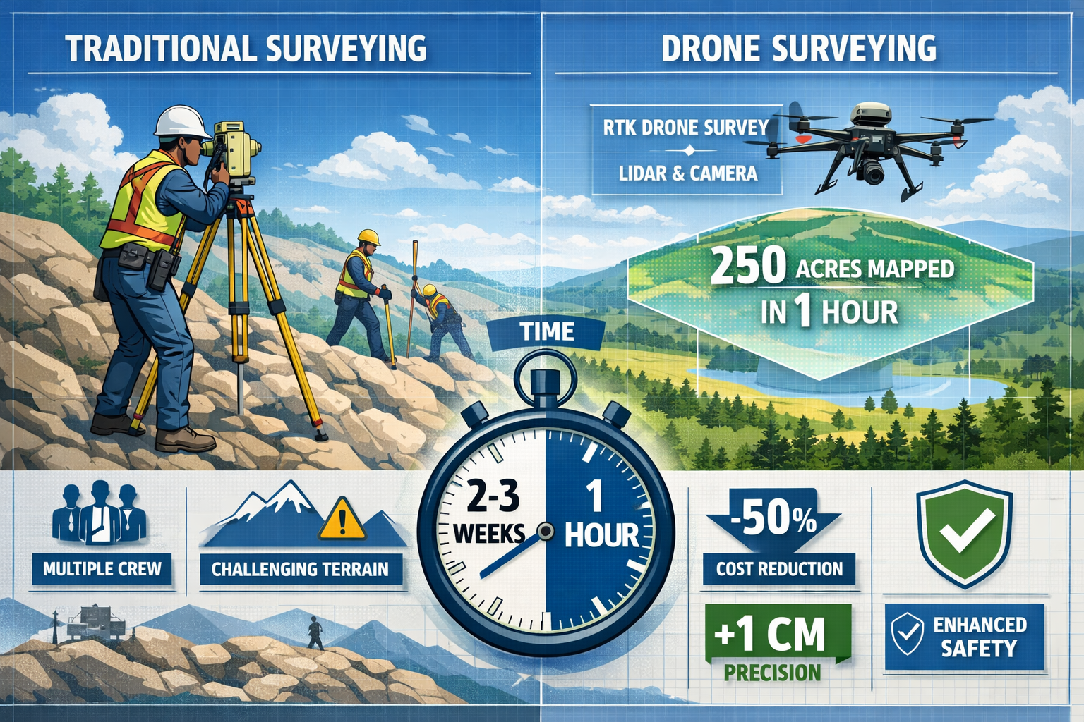
Modern unmanned aerial vehicles (UAVs) equipped with advanced LiDAR sensors and high-resolution cameras have evolved from expensive novelties into essential surveying instruments. These sophisticated platforms now deliver survey-grade accuracy that meets or exceeds traditional ground-based methods while dramatically reducing costs, timelines, and safety concerns.[1] The convergence of accessible drone technology, mature regulatory frameworks, and seamless integration with Geographic Information Systems (GIS) has created an ecosystem where property developers can make faster, more informed decisions based on comprehensive topographic data.
Key Takeaways
- Survey-grade precision is now standard: Modern drones equipped with RTK/PPK GNSS technology achieve centimeter-level accuracy, matching or surpassing traditional surveying methods while covering hundreds of acres in hours rather than weeks.[1]
- Regulatory frameworks have matured significantly: Beyond Visual Line of Sight (BVLOS) operations and autonomous drone-in-a-box systems are increasingly approved in 2026, enabling continuous infrastructure monitoring with Remote ID fully integrated into airspace management.[1]
- Seamless digital integration accelerates project timelines: Drone-captured data now flows directly into BIM, GIS platforms, and digital twin environments, with onboard AI enabling real-time validation and automated feature extraction that reduces manual review from days to hours.[1]
- Operational costs have decreased substantially: While initial investment remains significant, reduced field crew requirements, minimal site disruption, and faster deployment translate to dramatically lower surveying costs for property development projects.[2]
- LiDAR technology has reached new maturity levels: Advanced pulse repetition rates and improved IMU integration enable accurate data collection under dense vegetation with fewer ground control points, opening previously challenging terrain to efficient surveying.[1]
The Evolution from Costly to Accessible: How Drone Technology Became Mainstream for Land Surveying
The Price Revolution in Professional UAV Systems
The transformation of drone technology from prohibitively expensive specialized equipment to accessible professional tools represents one of the most significant shifts in surveying history. In 2026, property developers and surveying firms can acquire survey-grade UAV systems at price points that were unimaginable just five years ago. This democratization of technology has opened precision surveying capabilities to mid-sized development firms and independent professionals who previously relied exclusively on traditional methods or expensive third-party services.
Modern drone platforms integrate sophisticated sensors that would have cost hundreds of thousands of dollars as standalone units. RTK (Real-Time Kinematic) and PPK (Post-Processed Kinematic) GNSS technology now comes standard on professional surveying drones, delivering centimeter-level accuracy without requiring extensive ground control point networks.[1] This technological advancement fundamentally changes the economics of large-area surveys, where establishing and measuring dozens of ground control points previously consumed significant time and resources.
LiDAR Systems: From Specialized to Standard Equipment
The maturation of LiDAR (Light Detection and Ranging) technology for drone-mounted applications represents perhaps the most transformative development for property surveying. In 2026, LiDAR-equipped drones feature faster pulse repetition rates, improved inertial measurement unit integration, and enhanced accuracy even under dense forest canopies.[1] These improvements enable surveyors to capture detailed topographic data in environments where traditional methods struggle or photogrammetry proves inadequate.
For property development projects involving wooded areas or sites with significant vegetation, LiDAR's ability to penetrate canopy cover and capture ground-level elevation data proves invaluable. The technology generates highly detailed point clouds that reveal terrain features obscured by vegetation, enabling developers to assess grading requirements, drainage patterns, and construction challenges before clearing begins. This capability reduces project risk and enables more accurate cost estimation during the planning phase.
High-Resolution Cameras Surpassing Satellite Imagery
Survey drones in 2026 deliver imagery resolution significantly better than satellite-based alternatives like Google Earth, with higher point density and faster field deployment.[4] Modern UAV cameras capture imagery at ground sample distances measured in millimeters, revealing surface details invisible in satellite imagery. This resolution advantage proves critical for detailed property inspections where identifying specific features, materials, or conditions directly impacts development decisions.
The temporal advantage of drone-captured imagery cannot be overstated. While satellite imagery may be months or even years old, drone surveys provide current conditions captured within days of project initiation. For dynamic development sites where conditions change rapidly due to construction activity, weather events, or seasonal variations, this timeliness ensures decisions are based on accurate, up-to-date information rather than outdated satellite data.
Regulatory Maturation: How 2026 Rules Enable Efficient Drone Surveying Operations
Beyond Visual Line of Sight (BVLOS) Operations Become Routine
The regulatory landscape for commercial drone operations has evolved dramatically, with BVLOS operations becoming increasingly common for surveying applications in 2026.[1] This regulatory maturation enables surveying firms to conduct efficient linear infrastructure surveys—such as pipeline routes, transmission corridors, or highway alignments—without maintaining constant visual contact with the aircraft. The ability to survey extended linear features in single continuous flights rather than multiple segmented missions dramatically improves efficiency and data consistency.
BVLOS approvals require robust safety systems including detect-and-avoid technology, reliable command-and-control links, and comprehensive operational risk assessments. However, the streamlined approval processes now in place make these authorizations accessible to qualified surveying firms rather than exclusively available to large corporations with extensive regulatory resources. This accessibility enables mid-sized property development firms to leverage BVLOS capabilities for their surveying needs.
Autonomous Drone-in-a-Box Systems Transform Monitoring
Autonomous drone-in-a-box systems have transitioned from experimental concepts to operational reality in 2026.[1] These self-contained platforms enable scheduled inspections and surveys without human intervention, significantly reducing operational costs for property developers managing multiple sites or conducting ongoing monitoring during construction phases. The systems automatically launch, execute pre-programmed survey missions, return to their housing units, and transfer data to cloud platforms for processing—all without on-site personnel.
For large-scale property developments spanning months or years, autonomous systems enable regular progress monitoring, stockpile volume calculations, and site condition documentation at minimal incremental cost. The ability to schedule weekly or even daily surveys provides project managers with unprecedented visibility into construction progress and enables early identification of deviations from plans or potential issues requiring attention.
Remote ID Integration and Airspace Management
The full integration of Remote ID technology into airspace management systems represents a critical enabler for scaled drone operations in 2026.[1] Remote ID broadcasts identification and location information, enabling air traffic management systems, other aircraft, and authorized parties to identify drones operating in their vicinity. This transparency creates the foundation for safe integration of numerous commercial drone operations in shared airspace.
For surveying firms operating in urban or peri-urban environments where property development frequently occurs, Remote ID compliance ensures legal operation while contributing to overall airspace safety. The technology integrates seamlessly with modern drone platforms, requiring minimal additional effort from operators while enabling the regulatory framework that permits expanded commercial operations. Understanding these regulatory requirements and compliance standards is essential for firms incorporating drone surveying into their service offerings.
Drone Applications Transforming Land Surveying for Property Development in 2026: Core Capabilities and Workflows
Rapid Topographic Mapping Over Large Development Sites
The ability to survey hundreds of acres in hours rather than the days or weeks required by traditional ground-based methods represents the most immediately apparent advantage of drone surveying.[1][2][4] For property developers evaluating potential acquisition sites or planning large-scale developments, this speed advantage translates directly to faster decision-making and reduced holding costs during the planning phase.
A typical drone surveying workflow for a large property development site involves:
- Mission planning: Defining survey area boundaries, selecting appropriate flight altitude and overlap parameters, and establishing any necessary ground control points
- Field deployment: Transporting equipment to site, establishing base station (for RTK operations), and executing automated flight missions
- Data capture: Collecting imagery or LiDAR data with appropriate overlap and coverage
- Processing: Generating orthomosaic imagery, digital elevation models, and point clouds using photogrammetry or LiDAR processing software
- Deliverable creation: Producing survey-grade outputs including contour maps, volumetric calculations, and CAD-compatible files
This entire workflow, from arrival on-site to preliminary deliverables, can be completed within a single day for sites spanning hundreds of acres—a timeline impossible with traditional surveying methods.
Precise Boundary and Utility Surveys with GIS Integration
Modern drone surveying workflows integrate seamlessly with GIS platforms, enabling precise boundary delineation and utility mapping essential for property development.[1] High-resolution imagery and accurate positioning data enable surveyors to identify property corners, fence lines, easements, and existing infrastructure with precision matching traditional surveying methods. When combined with ground-based verification of critical control points, drone-captured data provides comprehensive spatial information for development planning.
The integration with GIS platforms enables sophisticated spatial analysis that informs development decisions. Surveyors can overlay drone-captured topography with property boundaries, zoning information, environmental constraints, and utility locations to create comprehensive site analysis products. These integrated datasets enable developers to identify optimal building locations, assess grading requirements, plan utility connections, and evaluate regulatory compliance—all within a unified digital environment.
For projects requiring detailed boundary surveys and property valuations, drone-captured data provides the foundational spatial information that supports accurate assessments and reduces uncertainty during the development process.
AI-Powered Feature Extraction and Real-Time Validation
The integration of artificial intelligence into drone surveying workflows represents a significant advancement in 2026.[1] Onboard AI systems enable real-time data validation during flight operations, alerting operators to coverage gaps, image quality issues, or sensor malfunctions before leaving the site. This immediate feedback prevents costly return visits and ensures complete data capture during initial deployment.
Post-processing AI algorithms automate feature extraction, identifying and classifying elements such as:
- Buildings and structures: Automatically delineating building footprints, measuring roof areas, and identifying structural features
- Roads and paved surfaces: Extracting pavement edges, centerlines, and surface condition information
- Utilities and infrastructure: Identifying visible utility features including manholes, poles, and overhead lines
- Vegetation and natural features: Classifying vegetation types, delineating water bodies, and identifying terrain features
This automated extraction reduces manual digitization time from days to hours, transforming raw survey data into actionable datasets significantly faster than traditional workflows. The time savings enable surveyors to deliver results more quickly while reducing labor costs associated with manual feature identification and classification.
Volumetric Analysis for Earthwork and Stockpile Management
Accurate volumetric calculations represent a critical application for property development projects involving significant earthwork. Drone surveying enables rapid, accurate measurement of cut-and-fill volumes, stockpile quantities, and excavation progress without the safety risks and site disruption associated with traditional ground-based measurement methods.[2]
The workflow for volumetric analysis involves:
- Establishing baseline conditions through initial survey
- Conducting periodic surveys at project milestones or regular intervals
- Generating digital surface models from each survey
- Calculating volumetric changes between survey epochs
- Producing reports documenting earthwork quantities and progress
This capability proves particularly valuable for large grading projects, mining operations, and construction sites where material management directly impacts project economics. The ability to conduct frequent surveys without disrupting operations enables project managers to track progress, verify contractor quantities, and identify discrepancies early when corrective action remains feasible and cost-effective.
Technical Capabilities: LiDAR, Photogrammetry, and Sensor Integration
LiDAR Technology Advances for Complex Terrain
The maturation of LiDAR systems for drone applications has opened new possibilities for surveying challenging terrain in 2026.[1] Modern systems feature pulse repetition rates exceeding one million points per second, enabling dense point cloud generation even during rapid flight operations. Improved inertial measurement unit integration ensures accurate positioning of each laser return, maintaining survey-grade accuracy even in environments where GNSS signals may be partially obstructed.
LiDAR's ability to penetrate vegetation canopy and capture multiple returns from different vertical levels within forested areas provides critical advantages for property development sites with significant tree cover. Surveyors can extract bare-earth digital elevation models showing ground surface topography beneath vegetation, enabling accurate grading plans and drainage design before clearing operations begin. This capability reduces uncertainty and enables more accurate cost estimation for site preparation work.
The reduced dependency on ground control points represents another significant advantage of modern LiDAR systems.[1] While some ground control remains necessary for absolute accuracy verification, advanced RTK/PPK integration enables accurate surveys with significantly fewer control points than photogrammetric workflows require. This reduction proves particularly valuable for remote sites, linear infrastructure projects, or locations where establishing extensive control networks presents logistical challenges.
Photogrammetry and Structure-from-Motion Processing
Photogrammetric workflows using structure-from-motion algorithms remain the most common approach for drone surveying in 2026, offering excellent results for sites with good ground visibility and texture. Modern processing software automatically generates dense point clouds, orthomosaic imagery, and digital surface models from overlapping photographs captured during automated flight missions.
The key advantages of photogrammetric approaches include:
- Lower equipment costs: High-quality cameras cost significantly less than LiDAR sensors
- True-color outputs: Photogrammetry produces orthomosaic imagery with natural color information valuable for visual interpretation
- Texture mapping: Generated 3D models include photographic texture enabling realistic visualization
- Established workflows: Mature processing pipelines and extensive software options support efficient production
However, photogrammetry requires adequate lighting conditions, sufficient surface texture for feature matching, and clear visibility of the ground surface. Dense vegetation, uniform surfaces, or poor lighting conditions can compromise results, making LiDAR the preferred choice for challenging environments.
Multi-Sensor Integration and Specialized Payloads
Advanced surveying drones in 2026 support multi-sensor configurations that capture complementary data types during single missions. Common combinations include:
- RGB camera + LiDAR: Combining true-color imagery with elevation data for comprehensive site documentation
- RGB + multispectral: Enabling vegetation health analysis and environmental assessment alongside standard surveying
- Thermal + RGB: Supporting utility location, moisture detection, and building envelope assessment
- Oblique cameras: Capturing facade imagery for 3D building modeling and structural assessment
This multi-sensor approach maximizes the value extracted from each site visit, enabling surveyors to deliver comprehensive datasets addressing multiple project requirements. For property development applications, the ability to assess environmental conditions, identify potential issues, and document existing conditions alongside topographic surveying adds significant value to the surveying investment.
Integration with Digital Workflows: BIM, GIS, and Digital Twins
Seamless BIM Integration for Construction Planning
The direct integration of drone survey data with Building Information Modeling (BIM) platforms creates powerful workflows for property development in 2026.[1] Accurate as-built terrain models generated from drone surveys provide the foundation for BIM environments, enabling architects and engineers to design buildings and infrastructure with precise understanding of existing site conditions.
The workflow typically involves:
- Importing drone-generated terrain models into BIM software
- Overlaying proposed building and infrastructure designs
- Analyzing cut-and-fill requirements for site grading
- Identifying conflicts between proposed construction and existing features
- Generating construction documentation with accurate site context
This integration enables clash detection between proposed designs and existing conditions before construction begins, reducing costly field changes and construction delays. The ability to visualize proposed buildings in accurate site context also supports stakeholder communication and regulatory approval processes.
For firms offering comprehensive surveying and project management services, the ability to deliver BIM-ready survey data differentiates their offerings and provides added value to development clients seeking integrated design and construction workflows.
GIS Platform Integration for Spatial Analysis
GIS integration enables sophisticated spatial analysis that informs property development decisions.[1] Drone-captured data layers combine with existing GIS datasets including property boundaries, zoning information, environmental constraints, utility locations, and demographic data to create comprehensive decision-support environments.
Common GIS analysis workflows for property development include:
- Site suitability analysis: Evaluating potential development sites based on topography, access, utilities, and regulatory constraints
- Viewshed analysis: Determining visibility from proposed building locations for marketing and design optimization
- Drainage analysis: Modeling surface water flow patterns to inform stormwater management design
- Environmental impact assessment: Analyzing impacts on wetlands, floodplains, and protected habitats
- Infrastructure planning: Optimizing utility routing and road alignments based on topography and existing features
The combination of current, accurate drone survey data with comprehensive GIS datasets enables developers to make informed decisions based on complete spatial information rather than relying on outdated maps or incomplete data sources.
Digital Twin Creation and Lifecycle Management
Digital twin technology represents the cutting edge of property development management in 2026.[1] These virtual replicas of physical assets create continuous feedback loops between real-world conditions and digital models, enabling ongoing monitoring, analysis, and optimization throughout the development lifecycle.
Drone surveying plays a critical role in digital twin creation and maintenance by:
- Establishing accurate baseline conditions during initial site assessment
- Documenting construction progress through periodic surveys
- Updating the digital twin with as-built conditions upon project completion
- Enabling ongoing condition monitoring and maintenance planning
For large mixed-use developments, master-planned communities, or commercial properties, digital twins provide facility managers and property owners with comprehensive information supporting operational decisions, maintenance planning, and future expansion or renovation projects. The investment in creating accurate digital twins during initial development pays dividends throughout the property lifecycle.
Cost-Benefit Analysis: Drone Surveying vs. Traditional Methods for Property Development
Direct Cost Comparisons and ROI Considerations
The operational cost advantages of drone surveying compared to traditional methods become increasingly apparent as project size increases.[2] While initial equipment investment remains substantial—professional survey-grade drone systems with RTK/PPK capabilities and LiDAR sensors can cost $50,000-$150,000—the operational cost per acre surveyed drops dramatically compared to traditional methods.
| Survey Method | Typical Cost per Acre | Time Required (100 acres) | Crew Size | Equipment Costs |
|---|---|---|---|---|
| Traditional Ground Survey | $500-$2,000 | 2-4 weeks | 2-4 personnel | $50,000-$100,000 |
| Drone Survey (Photogrammetry) | $50-$200 | 1-2 days | 1-2 personnel | $25,000-$75,000 |
| Drone Survey (LiDAR) | $100-$400 | 1-2 days | 1-2 personnel | $75,000-$150,000 |
These cost comparisons demonstrate the substantial per-acre savings achievable with drone surveying, particularly for large sites. The reduced crew requirements and dramatically shorter field time translate to lower labor costs while delivering comparable or superior accuracy.
For property developers evaluating survey pricing and service options, understanding these cost structures enables informed decisions about surveying approaches appropriate for specific project requirements and budgets.
Indirect Benefits: Speed, Safety, and Site Access
Beyond direct cost savings, drone surveying delivers significant indirect benefits that impact overall project economics:
Speed advantages enable faster decision-making during property acquisition, reducing holding costs and enabling developers to move quickly in competitive markets. The ability to survey a potential acquisition site within days rather than weeks can provide critical competitive advantage when multiple parties are evaluating the same property.
Safety improvements eliminate the need for survey crews to work in hazardous environments including steep slopes, unstable terrain, active construction zones, or areas with environmental hazards. This risk reduction translates to lower insurance costs, reduced liability exposure, and improved worker safety outcomes.[1]
Minimal site disruption proves particularly valuable for occupied properties, operating facilities, or environmentally sensitive areas where extensive ground-based surveying would require operational shutdowns, environmental permits, or extensive coordination. Drone surveys can often be conducted with minimal impact on ongoing activities, reducing indirect costs associated with site access and operational disruption.[2]
Scalability and Multi-Site Applications
For property development firms managing multiple projects or evaluating numerous potential acquisition sites, the scalability of drone surveying provides substantial advantages. A single drone system and trained operator can efficiently survey multiple sites, enabling firms to conduct comprehensive due diligence on multiple properties without proportionally increasing surveying costs.
The ability to maintain survey equipment in-house rather than contracting for traditional surveying services on each project provides both cost savings and schedule flexibility. Firms can conduct surveys on their own timeline without waiting for contractor availability, enabling faster response to opportunities and more agile project management.
Real-World Applications: Case Studies in Property Development Surveying
Large-Scale Residential Development: Comprehensive Site Analysis
A 300-acre residential development project demonstrates the comprehensive capabilities of modern drone surveying. The developer required detailed topographic information, environmental assessment, and infrastructure planning support for a master-planned community including single-family homes, multi-family buildings, commercial areas, and extensive amenities.
The surveying firm deployed a LiDAR-equipped drone with RTK positioning to capture comprehensive site data over two days of field operations. The resulting deliverables included:
- High-resolution topographic mapping with 6-inch contours
- Bare-earth digital elevation model showing ground surface beneath vegetation
- Multispectral imagery for wetland delineation and vegetation analysis
- Volumetric analysis for earthwork planning and cost estimation
- 3D visualization products for stakeholder presentations
The comprehensive dataset enabled the development team to optimize lot layouts, minimize earthwork costs, identify environmentally sensitive areas requiring protection, and plan utility infrastructure efficiently. The survey cost approximately $30,000—a fraction of the $150,000+ that traditional surveying methods would have required for comparable coverage and detail.
Commercial Property Redevelopment: As-Built Documentation
A commercial property redevelopment project required accurate as-built documentation of existing buildings, parking areas, and site features to support renovation planning and regulatory approval. The 15-acre urban site presented challenges for traditional surveying including active operations, limited access, and complex building geometries.
Drone surveying provided an ideal solution, capturing comprehensive site data during a single day of operations with minimal disruption to ongoing business activities. The survey included:
- Orthomosaic imagery at 1-inch ground sample distance
- Building footprint extraction and facade documentation
- Parking area striping and layout documentation
- Utility feature location and mapping
- Integration with existing survey control for absolute accuracy
The resulting datasets integrated directly into the architect's BIM environment, enabling accurate renovation design and reducing the risk of conflicts between proposed improvements and existing conditions. The ability to complete the survey without disrupting business operations provided substantial value beyond the direct cost savings compared to traditional methods.
Infrastructure Corridor: Linear Asset Surveying
A 25-mile utility corridor survey for a proposed natural gas pipeline demonstrates the advantages of BVLOS operations and linear asset surveying capabilities. The corridor crossed diverse terrain including agricultural land, forested areas, wetlands, and developed areas, presenting significant challenges for traditional surveying approaches.
The surveying firm utilized BVLOS-approved operations to conduct efficient continuous surveys of the corridor, capturing LiDAR data and high-resolution imagery across the entire alignment. The survey deliverables supported:
- Route optimization to minimize environmental impacts and construction costs
- Accurate profile and cross-section generation for engineering design
- Environmental constraint identification and permitting support
- Landowner communication through high-quality visualization products
- Construction planning and cost estimation
The ability to survey the entire corridor efficiently with minimal ground control point requirements demonstrated the maturity of BVLOS operations and the practical advantages for linear infrastructure projects. Traditional surveying methods would have required months of field operations and significantly higher costs to achieve comparable coverage and detail.
Challenges and Limitations: When Traditional Methods Remain Necessary
Accuracy Requirements and Boundary Surveys
While drone surveying achieves impressive accuracy for topographic mapping and site documentation, certain applications still require traditional ground-based methods. Legal boundary surveys establishing property lines for conveyance or resolving boundary disputes typically require ground-based measurements to property corners and monuments that cannot be accurately located from aerial imagery alone.
The best practice for property development projects often involves hybrid approaches combining drone surveying for comprehensive site mapping with targeted ground-based surveying for critical control points, property corners, and legal boundary establishment. This combination delivers the efficiency advantages of drone surveying while maintaining the legal defensibility and precision required for boundary determination.
For projects requiring comprehensive property surveys and valuations, understanding when to employ drone methods versus traditional approaches ensures appropriate methodology selection for specific project requirements.
Environmental and Operational Constraints
Certain environmental conditions limit drone surveying effectiveness:
- Adverse weather: High winds, precipitation, and poor visibility prevent safe drone operations
- Dense canopy: While LiDAR penetrates vegetation better than photogrammetry, extremely dense canopy can still limit ground surface visibility
- Reflective surfaces: Water bodies, glass, and highly reflective materials can compromise photogrammetric processing
- Electromagnetic interference: Areas near power lines, radio towers, or other sources of interference may affect drone navigation and control
Understanding these limitations enables surveyors to select appropriate methods for specific site conditions and plan contingencies when environmental factors may compromise drone operations.
Regulatory Restrictions and Airspace Constraints
Despite regulatory maturation, certain operational environments remain challenging for drone surveying:
- Controlled airspace: Operations near airports require coordination and may face restrictions on altitude or operational areas
- Restricted areas: Military installations, secure facilities, and certain government properties prohibit or severely restrict drone operations
- Privacy concerns: Operations over occupied residential areas may face objections from property owners or residents
- Urban environments: Dense urban areas present both regulatory challenges and practical obstacles including buildings, power lines, and limited launch/recovery areas
Experienced surveying firms navigate these challenges through proper planning, regulatory compliance, and stakeholder communication. However, some projects may require alternative approaches when regulatory or practical constraints make drone operations infeasible.
Future Developments: What's Next for Drone Surveying Technology

Enhanced Autonomy and AI Capabilities
The trajectory toward increased autonomy in drone surveying operations will continue beyond 2026, with AI systems taking on more decision-making responsibilities. Future developments likely include:
- Adaptive mission planning that adjusts flight parameters based on real-time conditions
- Automated obstacle avoidance enabling operations in complex environments
- Intelligent feature recognition during flight operations guiding data capture priorities
- Automated quality assessment and gap-filling without human intervention
These advancements will further reduce operational costs and enable less experienced operators to achieve professional-grade results, democratizing access to high-quality surveying capabilities.
Improved Sensor Technology and Integration
Sensor technology will continue advancing with improvements in:
- Higher-resolution cameras enabling finer ground sample distances
- More compact and affordable LiDAR systems bringing this capability to broader markets
- Hyperspectral sensors enabling detailed material identification and environmental analysis
- Improved thermal sensors supporting infrastructure assessment and utility location
The integration of multiple sensor types in compact, affordable packages will enable comprehensive multi-purpose surveys capturing diverse data types during single missions, maximizing efficiency and value.
Extended Range and Endurance
Battery technology improvements and more efficient aircraft designs will enable longer flight times and extended operational ranges. These advancements will reduce the number of flights required to survey large areas and enable operations in more remote locations without requiring nearby launch sites.
The combination of extended endurance with BVLOS approvals will enable truly efficient surveying of large properties and linear infrastructure, completing in single flights what currently requires multiple missions and battery changes.
Deeper Digital Integration
The integration between drone surveying and digital workflows will deepen, with automated processing pipelines delivering finished products with minimal human intervention. Cloud-based processing platforms will enable field operators to upload raw data and receive processed deliverables without requiring specialized software or processing expertise.
Integration with project management and certification workflows will enable drone survey data to flow seamlessly into comprehensive property development management systems, creating unified digital environments spanning the entire project lifecycle from initial site assessment through construction and ongoing facility management.
Selecting Drone Surveying Services: What Property Developers Should Know
Evaluating Service Provider Capabilities
Property developers selecting drone surveying services should evaluate providers based on several critical factors:
Equipment capabilities: Ensure the provider operates appropriate equipment for project requirements, including RTK/PPK positioning for accuracy, LiDAR sensors for vegetated terrain, and adequate camera resolution for required ground sample distance.
Regulatory compliance: Verify the provider holds appropriate certifications and approvals for planned operations, including Part 107 certification (or equivalent in your jurisdiction), BVLOS approvals if required, and appropriate insurance coverage.
Processing expertise: Assess the provider's capabilities in processing raw data into useful deliverables, including experience with relevant software platforms, ability to deliver in required formats, and quality control procedures ensuring accuracy.
Industry experience: Prioritize providers with specific experience in property development applications who understand project requirements and can deliver appropriate products supporting development decisions.
Defining Project Requirements and Deliverables
Clear communication of project requirements ensures surveying deliverables meet development needs:
Accuracy specifications: Define required accuracy levels for horizontal and vertical measurements, ensuring they align with project decision-making needs and regulatory requirements.
Deliverable formats: Specify required output formats including CAD files, GIS data, BIM models, or standard mapping products, ensuring compatibility with your design and analysis software.
Coverage areas: Clearly define survey boundaries, including any specific features requiring detailed documentation or areas where higher accuracy is required.
Timeline requirements: Communicate project schedule constraints and required delivery timelines, ensuring the provider can meet your deadlines.
For developers seeking comprehensive surveying solutions, establishing clear requirements upfront ensures efficient project execution and appropriate deliverables supporting development objectives.
Understanding Pricing Models and Cost Structures
Drone surveying pricing typically follows several models:
Per-acre pricing: Common for large-area surveys, with rates decreasing as total acreage increases
Day-rate pricing: Fixed daily rates for field operations plus processing fees
Project-based pricing: Fixed price for defined scope including field operations, processing, and specific deliverables
Subscription models: For ongoing monitoring or multi-site projects, monthly or annual subscription pricing
Understanding these pricing structures enables developers to evaluate proposals effectively and select cost-effective approaches for their specific requirements. The most economical approach often depends on project size, complexity, and whether ongoing surveying will be required throughout the development process.
Conclusion: Embracing the Drone Revolution in Property Development Surveying
The transformation of land surveying through drone applications in 2026 represents a fundamental shift in how property development professionals gather, analyze, and utilize spatial information. The convergence of accessible technology, mature regulatory frameworks, and seamless digital integration has created an ecosystem where survey-grade accuracy, rapid deployment, and comprehensive data capture are no longer competing objectives but complementary capabilities delivered through modern UAV platforms.
Property developers who embrace these technologies gain significant competitive advantages through faster decision-making, reduced surveying costs, and more comprehensive site understanding. The ability to survey hundreds of acres in hours, capture data beneath vegetation canopy with LiDAR, and integrate results directly into BIM and GIS environments transforms surveying from a project bottleneck into an enabler of agile, informed development decisions.
However, successful implementation requires understanding both the capabilities and limitations of drone surveying technology. Hybrid approaches combining drone surveying for comprehensive site mapping with targeted ground-based surveying for critical control and boundary determination often deliver optimal results. Selecting qualified service providers with appropriate equipment, regulatory compliance, and industry experience ensures projects receive professional-grade deliverables supporting development objectives.
Actionable Next Steps for Property Developers
Assess your current surveying approach: Evaluate recent projects to identify where drone surveying could have reduced costs, accelerated timelines, or improved decision-making through more comprehensive data.
Research qualified providers: Identify surveying firms in your market offering professional drone services with appropriate equipment and experience in property development applications. Request case studies and sample deliverables to assess capabilities.
Start with a pilot project: Select an appropriate project for initial drone surveying implementation—ideally a large site where the advantages will be most apparent—and compare results, costs, and timelines to traditional approaches.
Develop internal expertise: Consider training internal staff on drone surveying capabilities, deliverable interpretation, and integration with existing workflows to maximize value from surveying investments.
Plan for integration: Ensure your design and analysis software platforms can effectively utilize drone survey deliverables, upgrading systems if necessary to support BIM and GIS integration.
Stay informed on regulatory developments: Monitor evolving regulations affecting drone operations in your jurisdiction, particularly regarding BVLOS operations and autonomous systems that may expand future capabilities.
The drone applications transforming land surveying for property development in 2026 are not experimental technologies but proven, mature tools delivering measurable value across the development lifecycle. Property developers who effectively leverage these capabilities position themselves for success in an increasingly competitive and fast-paced market where informed decisions, rapid execution, and cost efficiency determine project outcomes.
References
[1] How Drones Are Transforming Surveying Mapping And Inspection In 2026 – https://www.uavsphere.com/post/how-drones-are-transforming-surveying-mapping-and-inspection-in-2026
[2] Drone Surveying – https://uavcoach.com/drone-surveying/
[3] How Technology Is Revolutionizing Land Surveys – https://www.firstchoicesurveying.com/blog/how-technology-is-revolutionizing-land-surveys
[4] Watch – https://www.youtube.com/watch?v=CSTodaZb4Vc
[5] Autonomous Drones In Land Surveying Capturing Large Properties With Single Flights In 2026 – https://nottinghillsurveyors.com/blog/autonomous-drones-in-land-surveying-capturing-large-properties-with-single-flights-in-2026