Rising sea levels are no longer a distant threat—they're reshaping coastlines in real-time, threatening billions of dollars in coastal property and infrastructure. As ocean waters advance and storm surges intensify, the race is on to map erosion patterns with unprecedented precision and establish property boundaries that can withstand climate disasters. Climate Change and Coastal Surveying: Advanced Techniques for Erosion Mapping and Disaster-Proof Boundaries represents the cutting edge of geospatial technology, where LiDAR drones, real-time GPS systems, and artificial intelligence converge to protect vulnerable communities from an uncertain future.
In 2026, coastal surveying has evolved from simple measurements to sophisticated multi-platform monitoring systems that track changes at the centimeter level. These advanced techniques don't just document erosion—they predict it, enabling communities to make informed decisions about property development, infrastructure investment, and climate adaptation strategies. From Southern California beaches experiencing unexpected growth to UK coastal communities preparing for transition, the story of coastal surveying is one of innovation meeting necessity.
Key Takeaways
- LiDAR drone technology delivers centimeter-level accuracy for coastal erosion mapping, generating digital elevation models that track topographical changes over time with unprecedented precision
- Multi-platform data fusion combines LiDAR, satellite imagery, RTK-GPS, and thermal imaging to create comprehensive coastal monitoring systems that predict erosion patterns and inform disaster-proof boundary establishment
- Nature-based solutions integrated with advanced surveying techniques have demonstrated measurable success, including documented 40 percent increases in dune height over three years in monitored coastal protection projects
- Real-time GIS systems enable dynamic property boundary adjustments in erosion-prone areas, protecting property rights while acknowledging the reality of shifting coastlines
- UK and US coastal programs are actively implementing advanced surveying techniques to support community adaptation, with updated risk assessments guiding transition strategies for vulnerable areas
Understanding the Climate Change Impact on Coastal Boundaries
The relationship between climate change and coastal boundaries has fundamentally transformed how surveyors approach their work. Traditional surveying methods assumed relatively stable coastlines, with property lines established decades ago remaining valid indefinitely. That assumption no longer holds true in an era of accelerating sea-level rise and intensifying storm events.
The Accelerating Erosion Challenge 🌊
Coastal erosion isn't a uniform process—it varies dramatically based on geography, geology, human intervention, and climate factors. Some coastlines experience rapid retreat measured in meters per year, while others show surprising resilience or even growth. Recent satellite imagery analysis reveals that Southern California beaches are actually experiencing growth that outpaces erosion, though this widening is driven largely by human intervention activities rather than natural processes[4].
This variability creates significant challenges for property owners, local governments, and surveyors. A property line established in 1990 might now sit several meters into the ocean, while neighboring parcels remain intact. The legal, financial, and practical implications are staggering:
- Property value uncertainty as erosion threatens coastal real estate investments
- Insurance complications with underwriters demanding precise erosion risk assessments
- Infrastructure planning requiring accurate predictions of future coastline positions
- Legal disputes over property boundaries that shift with changing shorelines
- Community displacement as erosion renders areas uninhabitable
Why Traditional Surveying Methods Fall Short
Conventional surveying techniques—while accurate for stable landscapes—struggle with the dynamic nature of coastal environments. Traditional methods typically involve:
- Periodic ground surveys conducted annually or less frequently
- Static boundary markers that don't account for coastal movement
- Limited spatial coverage requiring extensive fieldwork
- Time-consuming data collection vulnerable to weather delays
- Snapshot measurements that miss seasonal and storm-driven changes
These limitations become critical when communities need real-time data to make urgent decisions about evacuation routes, infrastructure hardening, or property development restrictions. The gap between traditional methods and climate-driven coastal changes has created an urgent need for advanced techniques.
Climate Change and Coastal Surveying: Advanced LiDAR and Drone Technologies
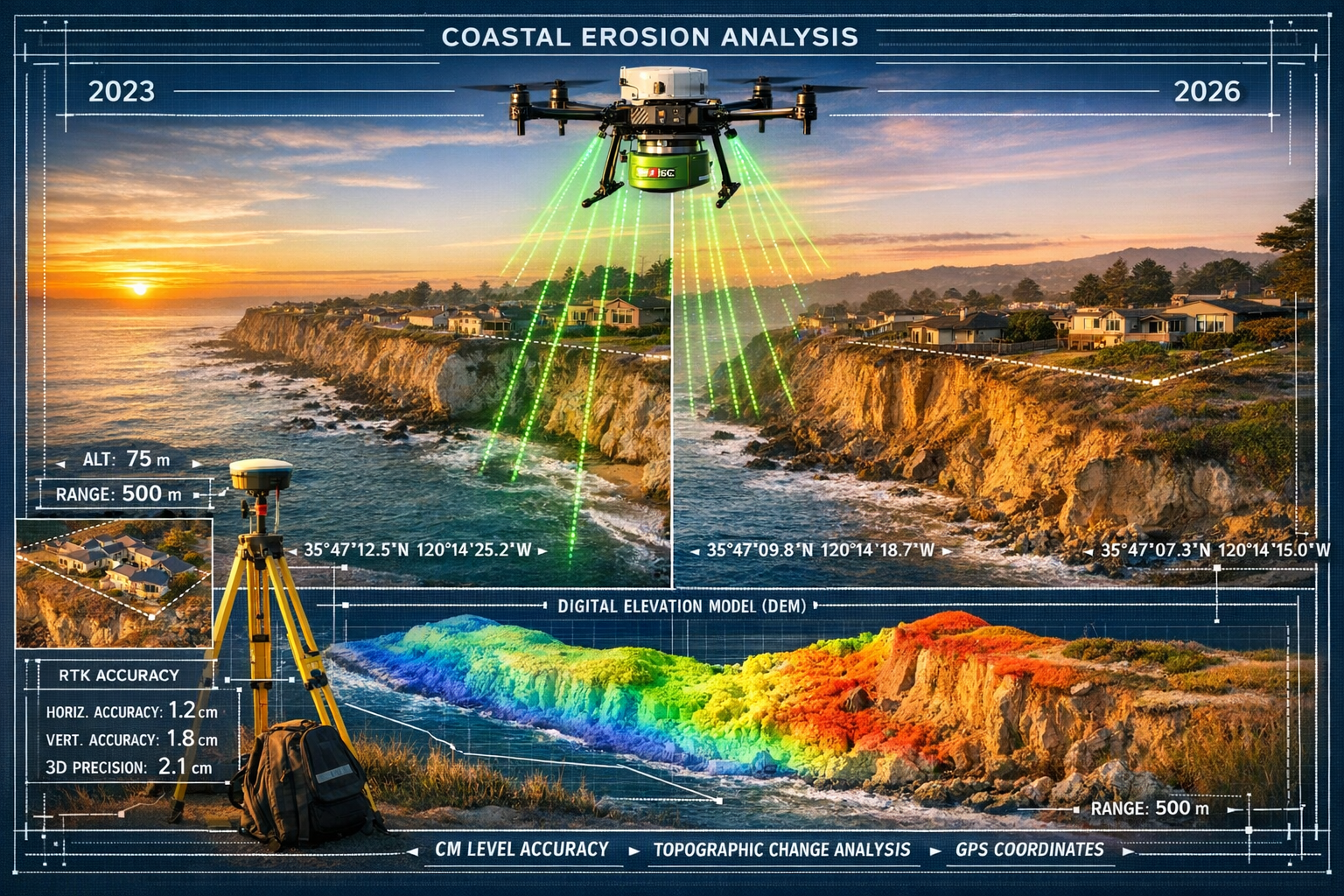
The revolution in coastal surveying centers on LiDAR (Light Detection and Ranging) technology deployed via unmanned aerial vehicles. This combination delivers the precision of traditional surveying with the speed and coverage area previously impossible to achieve.
How LiDAR Transforms Coastal Erosion Mapping
LiDAR-equipped drones revolutionize coastal monitoring by enabling rapid surveying of large coastal areas with centimeter-level accuracy. The technology works by emitting laser pulses that bounce off surfaces and return to sensors, measuring the time delay to calculate precise distances. These measurements generate digital elevation models (DEMs) essential for 3D representation of coastal landscapes and tracking topographical changes over time[1].
The advantages over traditional methods are substantial:
| Feature | Traditional Survey | LiDAR Drone Survey |
|---|---|---|
| Accuracy | ±5-10 cm | ±1-2 cm |
| Coverage Area/Day | 1-5 hectares | 50-200 hectares |
| Terrain Accessibility | Limited by physical access | Unlimited aerial access |
| Data Points Collected | Hundreds | Millions |
| Cost per Hectare | High | Significantly lower |
| Weather Dependency | Moderate | Lower (some systems) |
Commercial Systems Leading the Field
The RIEGL VQ-860-G represents the current state-of-the-art in topo-bathymetric laser scanning. This lightweight system acquires up to 100 high-resolution scans per second from altitudes between 75 to 300 meters, mapping both land and underwater topography for coastline cartography and submerged target detection[1]. This dual capability is crucial for understanding the complete coastal profile, including underwater features that influence erosion patterns.
For more accessible applications, the DJI Mavic 3 Enterprise Series features a 56× zoom camera and real-time kinematic (RTK) module for precise centimeter-level accuracy in coastal zone mapping. A thermal version enables nighttime operations and search-and-rescue applications[1], expanding surveying capabilities beyond traditional daylight-only operations.
These systems integrate seamlessly with professional structural engineering workflows, enabling surveyors to provide comprehensive assessments that inform coastal infrastructure design and property boundary determinations.
Software Integration and 3D Modeling Capabilities
Hardware alone doesn't create actionable intelligence—sophisticated software transforms raw LiDAR data into usable information. DJI Terra uses photogrammetry technology to create precise 2D and 3D reconstructions from visible light imagery, with AI-powered optimization of water surfaces and support for vegetation index mapping (NDVI and NDRE) to assess plant health in coastal restoration areas[1].
This software integration enables surveyors to:
- Generate time-series comparisons showing erosion progression over months or years
- Calculate volumetric changes in sand deposits or cliff faces
- Identify erosion hotspots requiring immediate intervention
- Model future scenarios based on current erosion rates
- Create stakeholder-friendly visualizations for community engagement
The ability to produce compelling visual evidence of coastal changes has proven invaluable for securing funding for coastal protection projects and supporting commercial property surveying decisions in erosion-prone areas.
Real-Time GIS Integration for Climate Change and Coastal Surveying: Advanced Techniques for Erosion Mapping and Disaster-Proof Boundaries
Geographic Information Systems (GIS) provide the analytical framework that transforms survey data into actionable coastal management strategies. Modern GIS platforms integrate multiple data streams to create comprehensive coastal monitoring ecosystems.
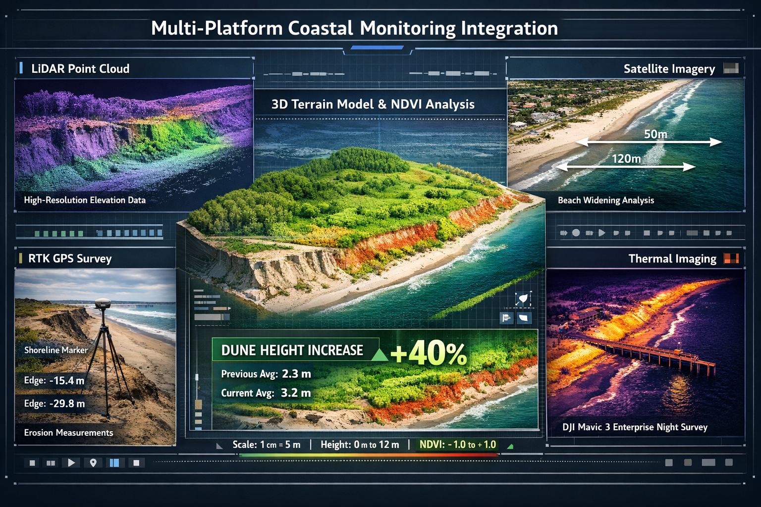
Multi-Platform Data Fusion Approach
Modern coastal monitoring integrates LiDAR, direct distance measurement, aerial photography, laser scanning, and satellite imaging to create layered understanding of coastal morphology dynamics and erosion progression[1]. This multi-platform approach addresses the limitations of any single technology:
- LiDAR provides high-precision elevation data and vegetation penetration
- Satellite imagery offers broad coverage and historical comparison capabilities
- Aerial photography delivers visual context and feature identification
- RTK-GPS establishes precise georeferencing and ground control points
- Thermal imaging reveals moisture patterns indicating subsurface erosion
The NOAA Digital Coast platform provides free tools for integrating these data sources, enabling even resource-constrained communities to implement sophisticated coastal monitoring programs[5]. These tools support everything from basic shoreline change analysis to complex storm surge modeling.
Open-Source and Accessible Mapping Solutions
Not every coastal monitoring project requires cutting-edge commercial systems. Google Earth provides a free method for assessing shoreline erosion history using satellite imagery combined with analysis tools like Microsoft PowerPoint, though this technique provides rough evaluation rather than exact erosion rates[2]. This accessibility democratizes coastal monitoring, enabling community groups and smaller municipalities to track changes affecting their areas.
The Great Lakes region has developed particularly robust open-source tools and resources for coastal erosion assessment[6], recognizing that smaller communities often lack budgets for commercial surveying systems. These resources include:
- Step-by-step guides for conducting basic erosion assessments
- Templates for documenting coastal changes
- Community science protocols for data collection
- Integration methods for combining amateur and professional data
For property owners concerned about erosion affecting their investments, these accessible tools provide preliminary assessments before commissioning professional RICS building surveys or boundary surveys.
Establishing Disaster-Proof Property Boundaries
The concept of "disaster-proof" boundaries represents a paradigm shift in coastal property surveying. Rather than establishing fixed lines that erosion will inevitably compromise, advanced techniques create dynamic boundary systems that acknowledge coastal change while protecting property rights.
These systems typically involve:
- Primary boundary markers established using RTK-GPS at centimeter-level accuracy
- Reference networks of permanent monuments inland from erosion zones
- Digital boundary records updated regularly based on erosion monitoring
- Trigger mechanisms that activate boundary adjustments when erosion reaches defined thresholds
- Legal frameworks supporting dynamic boundaries in local regulations
The UK Environment Agency is updating its national coastal erosion risk map and assessment of properties and infrastructure at risk from erosion in a changing climate, improving understanding of coastal transition needs[3]. This national-level effort provides the regulatory foundation for implementing dynamic boundary systems across vulnerable coastlines.
Case Studies: Climate Change and Coastal Surveying: Advanced Techniques in Vulnerable Areas
Real-world applications demonstrate how advanced surveying techniques translate into measurable coastal protection outcomes and community resilience.
Southern California Beach Monitoring Success
The recent USGS and University of California, Irvine joint study utilized satellite imagery analysis to document beach widening across Southern California[4]. This unexpected finding—growth outpacing erosion—emerged only through consistent, technology-enabled monitoring. The study revealed that human intervention activities, including sand replenishment projects and coastal structure modifications, drove this growth.
The implications for coastal surveying are significant:
- Validation of intervention effectiveness through quantifiable measurements
- Identification of successful techniques for replication elsewhere
- Evidence-based resource allocation for coastal management programs
- Predictive modeling improvement by incorporating human intervention variables
This case demonstrates how advanced surveying moves beyond simple documentation to become a feedback mechanism that improves coastal management strategies over time.
Urban Coastal Adaptation: The Calafell Model
Urban coastal projects are incorporating nature-based solutions alongside technological monitoring. In Calafell, the city council removed promenade sections to create natural sand deposits and improve storm resilience using LiDAR-verified techniques[1]. This project exemplifies the integration of:
- Baseline LiDAR surveys documenting pre-intervention conditions
- Regular monitoring tracking sand accumulation and dune formation
- Performance verification confirming nature-based solutions deliver predicted benefits
- Adaptive management adjusting interventions based on monitoring data
A specific coastal protection project demonstrated 40 percent increase in dune height over three years, with an average rise of 2 meters, using LiDAR-equipped drones for centimeter-level accuracy measurements[1]. These documented results provide compelling evidence for investing in nature-based coastal protection integrated with advanced monitoring.
Similar approaches could benefit properties requiring structural surveys in coastal zones, where understanding erosion dynamics informs foundation design and property development decisions.
UK Coastal Transition Programme Implementation
The UK's Coastal Transition Accelerators Programme actively supports communities in areas at significant risk of coastal erosion to adapt to climate change, with the Environment Agency tracking best practices and lessons learned from implementation[3]. This national program demonstrates government-scale application of advanced surveying techniques.
Key components include:
- Community engagement using 3D visualizations from LiDAR data to communicate erosion risks
- Property-level assessments determining which structures face imminent threats
- Infrastructure planning relocating critical services before erosion compromises them
- Legal framework development supporting managed retreat and property rights transitions
- Financial mechanisms compensating property owners affected by erosion
The programme's success depends heavily on accurate, regularly updated erosion mapping—exactly what advanced surveying techniques provide. Communities receive not just data, but actionable intelligence that informs difficult decisions about their futures.
For surveyors working in coastal areas, understanding these programmes is essential for providing clients with comprehensive advice. Properties in erosion zones may require specialized RICS valuations that account for climate risks and potential transition requirements.
Implementing Advanced Coastal Surveying Techniques: Practical Considerations
Transitioning from traditional to advanced coastal surveying requires careful planning, investment, and skill development. Organizations and communities considering implementation should address several key factors.
Cost-Benefit Analysis and ROI
Drone-based LiDAR surveying is significantly more economical and efficient than traditional ground surveys, as data can be rapidly combined with satellite imaging and ground surveys to create comprehensive models showing spatial distribution of erosion patterns[1]. However, initial equipment investment can be substantial:
Initial Investment Components:
- LiDAR-equipped drone system: £15,000-£150,000 depending on capabilities
- Processing software licenses: £2,000-£10,000 annually
- Training and certification: £3,000-£8,000 per operator
- Ground control equipment: £5,000-£20,000
- Data storage and computing infrastructure: £3,000-£15,000
Operational Cost Advantages:
- 10-20x faster data collection than traditional methods
- Reduced field time minimizing weather-related delays
- Single operator can survey areas requiring teams with traditional methods
- Repeatable surveys enabling consistent time-series analysis
- Reduced risk in accessing hazardous coastal areas
For most coastal communities and surveying firms, the investment pays for itself within 2-3 years through efficiency gains and expanded service capabilities. The technology also enables services previously impractical, such as monthly erosion monitoring or post-storm damage assessment.
Training and Certification Requirements
Operating advanced surveying systems requires specialized knowledge beyond traditional surveying skills:
- Drone pilot certification meeting civil aviation authority requirements
- LiDAR system operation including calibration and quality control
- GIS software proficiency for data processing and analysis
- Photogrammetry principles for accurate 3D reconstruction
- Coastal geomorphology understanding erosion processes and patterns
Professional organizations increasingly offer specialized training programs combining these skills. The RICS (Royal Institution of Chartered Surveyors) recognizes the growing importance of these capabilities in chartered surveying practice.
Data Management and Sharing Protocols
Advanced surveying generates enormous data volumes—a single coastal survey can produce hundreds of gigabytes of point cloud data. Effective data management requires:
- Standardized formats ensuring interoperability between systems and organizations
- Cloud storage solutions providing secure access for stakeholders
- Version control systems tracking data updates and revisions
- Metadata standards documenting collection methods, accuracy, and dates
- Sharing agreements balancing public access with privacy concerns
Many coastal communities establish data cooperatives where multiple organizations contribute to shared databases, maximizing the value of individual surveys. These cooperatives often integrate with national programs like NOAA's Digital Coast, contributing local data to broader coastal monitoring efforts.
Integration with Property Development and Infrastructure Planning
Advanced coastal surveying doesn't exist in isolation—its greatest value emerges when integrated into broader planning and development processes.
Informing Climate-Resilient Development Decisions
Property developers and infrastructure planners increasingly demand erosion risk assessments before committing resources to coastal projects. Advanced surveying provides the foundation for these assessments:
- Projected erosion rates over 10, 25, and 50-year timeframes
- Storm surge vulnerability based on current and projected topography
- Foundation requirements accounting for future erosion scenarios
- Setback recommendations ensuring structures remain viable through their design life
- Insurance implications with accurate risk data supporting coverage decisions
This integration transforms surveying from a compliance exercise into a strategic planning tool that protects investments and lives. Developers working in coastal zones should request comprehensive erosion assessments as part of standard commercial building surveys.
Supporting Nature-Based Infrastructure Solutions
The documented success of nature-based coastal protection—like the 40 percent dune height increase mentioned earlier—has shifted infrastructure planning toward hybrid approaches combining traditional engineering with natural systems. Advanced surveying enables:
- Baseline documentation of existing natural features
- Performance monitoring verifying nature-based solutions work as designed
- Adaptive management adjusting interventions based on monitoring data
- Cost-effectiveness analysis comparing natural and engineered solutions
- Co-benefit quantification measuring ecosystem services alongside erosion protection
These approaches often prove more cost-effective and sustainable than traditional seawalls and revetments, while providing additional benefits like habitat creation and recreational opportunities.
Legal and Regulatory Compliance
Coastal development faces increasingly stringent regulations as governments respond to climate change. Advanced surveying supports compliance by:
- Documenting existing conditions before development begins
- Demonstrating adherence to setback requirements
- Supporting environmental impact assessments
- Providing evidence for permit applications
- Enabling post-construction monitoring confirming compliance
Surveyors familiar with these regulatory frameworks provide invaluable guidance to clients navigating complex approval processes. Understanding requirements for specific defect surveys in coastal contexts ensures comprehensive property assessments.
Future Trends in Climate Change and Coastal Surveying: Advanced Techniques for Erosion Mapping and Disaster-Proof Boundaries
The field continues evolving rapidly, with emerging technologies promising even greater capabilities for coastal monitoring and protection.
Artificial Intelligence and Predictive Modeling
Machine learning algorithms are increasingly applied to coastal survey data, enabling:
- Automated change detection identifying erosion hotspots from repeat surveys
- Predictive erosion modeling forecasting future coastline positions
- Pattern recognition identifying erosion drivers from complex datasets
- Anomaly detection flagging unexpected changes requiring investigation
- Optimization algorithms recommending intervention strategies
These AI applications transform reactive monitoring into proactive management, enabling interventions before erosion causes irreversible damage.
Autonomous Survey Systems
The next generation of coastal monitoring will likely involve autonomous systems requiring minimal human intervention:
- Automated drone missions conducting scheduled surveys without operators
- Permanent monitoring stations with fixed LiDAR systems tracking changes continuously
- Underwater autonomous vehicles mapping submerged erosion features
- Satellite constellation integration providing daily coastal imagery
- IoT sensor networks detecting real-time changes in coastal conditions
These systems will enable continuous monitoring at costs approaching those of current periodic surveys, fundamentally changing how communities understand and respond to coastal change.
Climate Scenario Integration
Future surveying systems will integrate climate projections directly into erosion mapping:
- Sea-level rise scenarios from IPCC models incorporated into boundary planning
- Storm intensity projections informing infrastructure design standards
- Temperature change impacts on coastal vegetation and natural protection
- Precipitation pattern shifts affecting cliff stability and erosion rates
- Multi-stressor modeling accounting for combined climate impacts
This integration will enable truly forward-looking coastal planning that anticipates rather than reacts to climate change.
Conclusion: Building Coastal Resilience Through Advanced Surveying
Climate Change and Coastal Surveying: Advanced Techniques for Erosion Mapping and Disaster-Proof Boundaries represents far more than technological innovation—it embodies a fundamental shift in how humanity relates to dynamic coastlines. The combination of LiDAR drones, real-time GIS, multi-platform data fusion, and AI-powered analysis provides unprecedented capability to understand, predict, and respond to coastal erosion.
The evidence is compelling: centimeter-level accuracy measurements track changes previously invisible, documented 40 percent dune height increases validate nature-based interventions, and comprehensive monitoring programs support entire communities through coastal transitions. From Southern California's widening beaches to UK coastal communities preparing for managed retreat, advanced surveying techniques inform decisions protecting lives, property, and ecosystems.
Actionable Next Steps
For Coastal Property Owners:
- Commission professional erosion assessments using advanced surveying techniques
- Request time-series data showing historical erosion rates affecting your property
- Explore boundary surveys establishing precise property lines before erosion complicates matters
- Consider nature-based protection options validated through monitoring data
- Engage with local coastal transition programs to understand long-term risks
For Local Governments and Planners:
- Invest in regular LiDAR-based coastal monitoring programs
- Establish data-sharing cooperatives maximizing survey value
- Develop regulatory frameworks supporting dynamic property boundaries
- Integrate erosion projections into comprehensive planning processes
- Support community engagement using 3D visualizations from survey data
For Surveying Professionals:
- Pursue specialized training in LiDAR, drone operation, and coastal geomorphology
- Invest in equipment enabling advanced coastal surveying services
- Develop partnerships with GIS specialists and coastal engineers
- Stay current with emerging AI and autonomous surveying technologies
- Engage with professional organizations advancing coastal surveying standards
For Researchers and Technology Developers:
- Continue refining AI algorithms for erosion prediction and change detection
- Develop more affordable surveying systems for resource-constrained communities
- Improve integration between satellite, aerial, and ground-based monitoring
- Create user-friendly interfaces making advanced tools accessible to non-specialists
- Validate nature-based solutions through rigorous monitoring programs
The coastlines of 2026 face unprecedented challenges, but they also benefit from unprecedented monitoring and protection capabilities. By embracing advanced surveying techniques, communities can make informed decisions that balance development aspirations with climate realities, protecting both property rights and human safety. The technology exists—the challenge now is implementation at the scale climate change demands.
For comprehensive surveying services incorporating the latest coastal monitoring techniques, explore our full range of professional surveys or contact our team for specialized coastal property assessments.
References
[1] Coastal Erosion – https://www.wipo.int/web-publications/green-technology-book-solutions-for-confronting-climate-disasters/en/coastal-erosion.html
[2] Using Google Earth Estimate Shoreline Erosion History – https://nerrssciencecollaborative.org/resource/using-google-earth-estimate-shoreline-erosion-history
[3] Fcerm Strategy Roadmap To 2026 Final – https://assets.publishing.service.gov.uk/media/629de862e90e07039c27b440/FCERM-Strategy-Roadmap-to-2026-FINAL.pdf
[4] Satellite Imagery Shows Beach Widening Southern California Driven Human – https://www.usgs.gov/programs/cmhrp/news/satellite-imagery-shows-beach-widening-southern-california-driven-human
[5] Tools – https://coast.noaa.gov/digitalcoast/tools/
[6] Tools Resources – https://restoreyourcoast.org/coastalerosion/great-lakes/tools-resources/