The construction industry stands at a technological crossroads in 2026, where the precision of traditional land surveying meets the digital sophistication of Building Information Modeling (BIM). BIM Integration for Land Surveyors: Enhancing Construction Project Efficiency represents more than just a technological upgrade—it's a fundamental transformation in how construction projects are conceived, planned, and executed. Land surveyors who once simply measured and mapped terrain now serve as the critical architects of digital foundations, feeding geospatial data into BIM models that prevent costly conflicts and streamline collaboration with architects, engineers, and construction teams.
The stakes have never been higher. Construction projects utilizing BIM integration have documented 10% cost and time savings while simultaneously improving overall quality and performance.[2] Yet these benefits materialize only when surveyors understand their pivotal role in the BIM ecosystem and master the techniques for delivering accurate, compatible geospatial data that serves as the "virtual foundations" of every successful BIM model.[3]
Key Takeaways
- 🎯 Surveyors provide the critical foundation: Land surveyors create the precise geospatial data that forms the virtual foundations of BIM models, making them the essential first link in BIM-related processes throughout a project's lifecycle.[3]
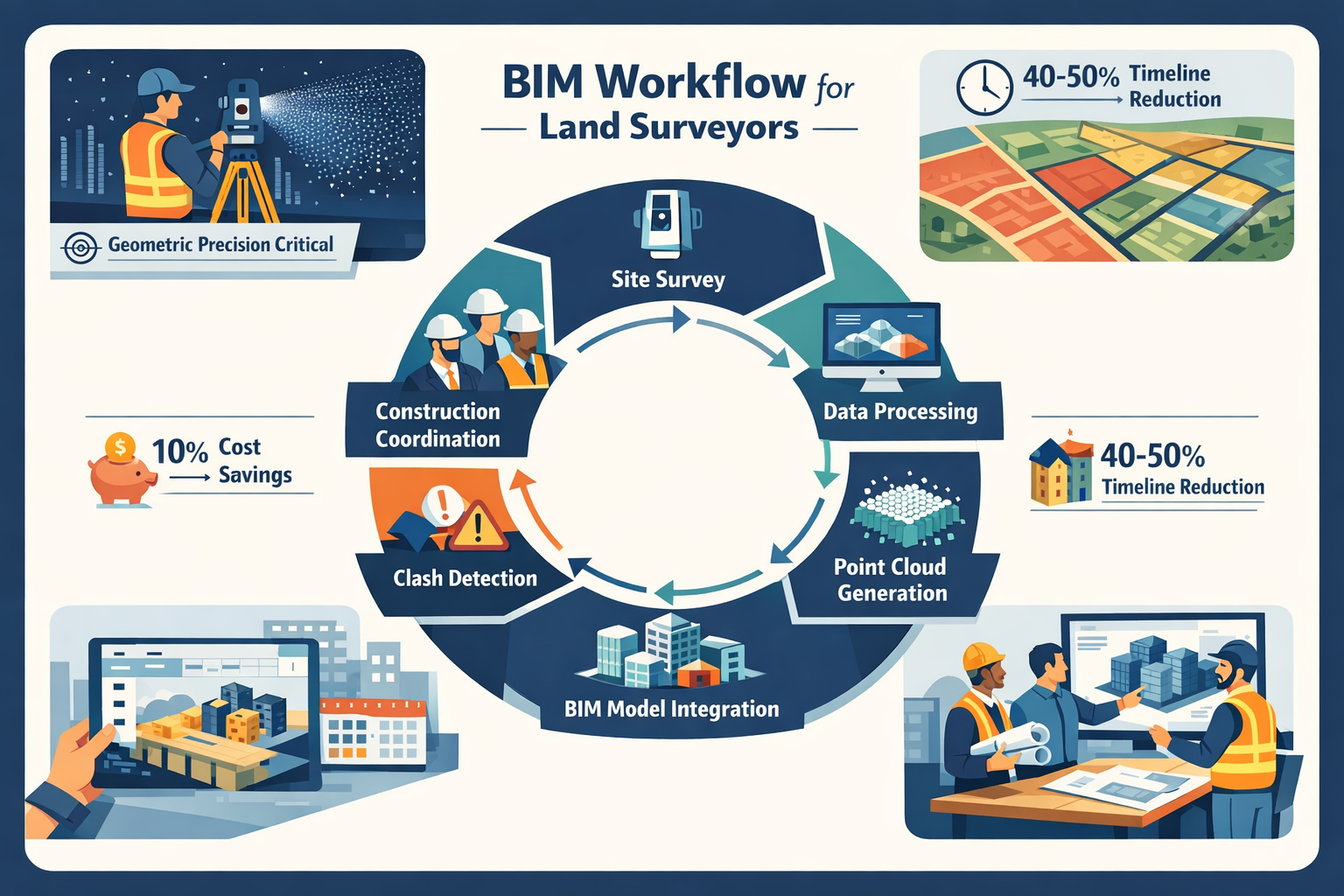
- 💰 Documented efficiency gains: Projects implementing BIM integration achieve 10% cost and time savings, with potential timeline reductions of 40-50% when combined with GIS integration.[2][6]
- 🔍 Geometric precision is non-negotiable: BIM success depends entirely on accurate survey data—flawed input data compromises the entire model and all downstream decisions.[4]
- 🤝 Collaboration transforms workflows: BIM creates a single source of truth that enables seamless coordination between surveyors, architects, engineers, and construction professionals, preventing conflicts before they occur.[4]
- 📈 Growing demand for BIM-skilled surveyors: The construction industry increasingly seeks land surveyors proficient in BIM integration, creating significant career advancement opportunities.[1]
Understanding BIM Integration for Land Surveyors: The Foundation of Modern Construction

What Is BIM and Why Surveyors Are Essential
Building Information Modeling (BIM) represents a comprehensive digital approach to designing, constructing, and managing buildings and infrastructure. Unlike traditional 2D drawings, BIM creates data-rich 3D models that contain detailed information about every component of a structure—from dimensions and materials to costs and maintenance schedules.
Land surveyors occupy a unique position in this digital ecosystem. While architects design structures and engineers ensure structural integrity, surveyors provide the geometric precision that defines physical boundaries, constraints, and existing conditions of the built environment.[4] Without accurate survey data, BIM models float in a virtual void, disconnected from real-world coordinates and unable to account for actual site conditions.
Construction cannot proceed without clearly plotted land data, and valid BIM models cannot be formulated without real-world surveying parameters.[3] This fundamental truth elevates surveyors from data collectors to essential collaborators whose work influences every subsequent decision in the construction process.
The Evolution of Surveying in the BIM Era
Traditional surveying focused primarily on measurement and documentation—establishing property boundaries, creating topographic maps, and providing elevation data. The BIM revolution has expanded these responsibilities dramatically:
Traditional Surveying Tasks:
- Boundary determination
- Topographic mapping
- Elevation certificates
- Construction staking
- As-built documentation
BIM-Enhanced Surveying Responsibilities:
- Point cloud generation and processing
- 3D model georeferencing
- Clash detection support
- Real-time construction monitoring
- Digital twin maintenance
- Collaborative model coordination
This evolution requires surveyors to develop new technical competencies while maintaining the precision standards that have always defined the profession. The chartered surveyors who thrive in 2026 are those who embrace both traditional accuracy and digital innovation.
The Single Source of Truth Concept
One of BIM's most powerful benefits is establishing a single source of truth—a unified, authoritative dataset that all project stakeholders reference.[4] When surveyors integrate accurate geospatial data into BIM models, they create this foundation that enables:
✅ Better collaboration across disciplines
✅ Risk mitigation through early conflict detection
✅ Cost control via accurate quantity takeoffs
✅ Quality assurance through continuous validation
✅ Lifecycle management extending beyond construction
However, this single source of truth is only as reliable as the survey data supporting it. If input data is flawed, the entire model and all downstream decisions become compromised.[4] This reality places enormous responsibility—and opportunity—on the shoulders of land surveyors.
Advanced Surveying Technologies Feeding BIM Models
Laser Scanning and Point Cloud Generation
Laser scanning technology has revolutionized how surveyors capture existing conditions. Modern terrestrial laser scanners can capture millions of data points per second, creating highly detailed "point clouds" that represent precise three-dimensional representations of real-world environments.[4]
How Laser Scanning Supports BIM Integration:
| Technology Aspect | BIM Benefit | Practical Application |
|---|---|---|
| High-density data capture | Comprehensive existing conditions | Renovation and retrofit projects |
| Millimeter-level accuracy | Precise geometric modeling | Structural alignment verification |
| Rapid data collection | Reduced site time | Minimal disruption to active sites |
| 360-degree coverage | Complete spatial documentation | Complex infrastructure mapping |
| Color capture | Visual context | Client presentations and validation |
Point clouds serve multiple purposes in BIM workflows. Architects use them to understand existing structures before designing additions. Engineers reference them to verify clearances and identify potential conflicts. Construction managers compare them against design models to monitor progress and ensure quality.
The key to effective point cloud integration lies in processing and registration. Raw point cloud data must be cleaned, aligned to control points, and converted into formats compatible with BIM software platforms. Surveyors skilled in this processing workflow become invaluable project team members.
Control Surveys and Georeferencing
While laser scanning captures detailed geometry, control surveys provide the high-precision georeferencing that anchors BIM models to real-world coordinates.[4] This georeferencing ensures that:
- Models align with actual site locations
- Multiple survey datasets integrate seamlessly
- Construction equipment receives accurate guidance
- As-built documentation matches design intent
- Future modifications reference correct positions
Establishing robust control networks requires traditional surveying expertise combined with modern GPS/GNSS technology. The most effective approach typically involves:
- Primary control points established using high-precision GNSS observations
- Secondary control extended through total station traverses
- Check measurements validating network accuracy
- Coordinate transformation parameters for BIM software integration
- Documentation protocols ensuring reproducibility
This control framework becomes the skeleton upon which all BIM data hangs. Without it, even the most detailed laser scans and sophisticated models lack the spatial integrity required for construction implementation.
Mobile Mapping and Continuous Data Collection
Emerging mobile mapping technologies enable surveyors to capture data while moving through sites, dramatically increasing efficiency for linear infrastructure projects like roads, railways, and utilities. These systems combine:
- LiDAR scanners for geometric data
- High-resolution cameras for visual context
- GNSS receivers for positioning
- IMU sensors for orientation tracking
The resulting datasets integrate seamlessly into BIM workflows, providing corridor-wide coverage that would require weeks to capture using stationary methods. For commercial property surveying projects involving large sites or complex infrastructure, mobile mapping represents a game-changing efficiency improvement.
GIS Integration for Comprehensive Context
Geographic Information Systems (GIS) integration extends BIM capabilities beyond individual structures to encompass broader site context. Surveyors increasingly overlay zoning regulations, utility networks, environmental constraints, and ownership boundaries onto BIM models, enabling smarter land management decisions.[6]
This integration has demonstrated potential to reduce project timelines by 40-50% by identifying conflicts and constraints during early planning phases rather than during construction.[6] The combination of surveying precision, BIM modeling, and GIS analysis creates a comprehensive digital environment where stakeholders can visualize, analyze, and optimize projects before breaking ground.
BIM Integration for Land Surveyors: Practical Implementation Strategies
Data Capture Planning and Coordination
Successful BIM integration begins long before surveyors arrive on site. Effective implementation requires careful planning and coordination with all project stakeholders:
Pre-Survey Coordination Checklist:
📋 Project Requirements Definition
- Identify specific BIM deliverables required
- Establish accuracy tolerances and standards
- Define coordinate systems and datums
- Determine file formats and exchange protocols
- Clarify update frequency and versioning
📋 Stakeholder Communication
- Coordinate with architects on design intent
- Discuss with engineers regarding critical dimensions
- Align with construction teams on phasing needs
- Engage with facility managers on lifecycle requirements
- Establish communication protocols and schedules
📋 Technology Selection
- Choose appropriate surveying instruments
- Select compatible software platforms
- Verify data processing capabilities
- Ensure adequate computing resources
- Plan for data backup and security
This upfront planning prevents the common scenario where surveyors collect extensive data that doesn't align with BIM requirements or arrives in incompatible formats. The growing demand for surveyors skilled in BIM integration reflects the industry's recognition that technical proficiency alone is insufficient—successful practitioners must also excel at collaborative planning.[1]
Data Processing and Quality Assurance
Raw survey data rarely flows directly into BIM models. Effective integration requires systematic processing and rigorous quality assurance:
Point Cloud Processing Workflow:
- Registration: Align multiple scan positions using targets or cloud-to-cloud methods
- Cleaning: Remove noise, outliers, and irrelevant features
- Classification: Identify ground, buildings, vegetation, and utilities
- Meshing: Convert point clouds to surface models where appropriate
- Simplification: Reduce file sizes while maintaining critical detail
- Validation: Compare against control surveys and check measurements
Quality Control Measures:
✓ Verify closure on control traverses
✓ Check overlap consistency between scan positions
✓ Validate dimensions against known measurements
✓ Confirm coordinate system transformations
✓ Document accuracy assessments and limitations
✓ Maintain audit trails for all processing steps
Quality assurance extends beyond technical accuracy to encompass data completeness and usability. A perfectly accurate point cloud that's missing critical areas or delivered in an unusable format provides little value. Surveyors must balance precision with practicality, understanding how their data will be used throughout the project lifecycle.
Model Integration and Clash Detection
Once processed survey data is ready, the actual BIM integration process begins. This typically involves:
Survey-to-BIM Integration Steps:
- Import survey data into BIM authoring software (Revit, ArchiCAD, etc.)
- Establish coordinate alignment between survey and model coordinate systems
- Create reference surfaces from topographic data
- Model existing conditions from point cloud data
- Validate alignment between survey and design elements
- Participate in clash detection reviews
- Update models as construction progresses
Clash detection represents one of BIM's most valuable capabilities—the ability to identify conflicts between different building systems before construction begins. AI algorithms can now identify possible design clashes or conflicts in advance, minimizing delays and ensuring high-quality project delivery.[2]
Surveyors contribute to clash detection by:
- Providing accurate existing conditions that reveal conflicts with proposed designs
- Identifying site constraints that affect constructability
- Monitoring construction progress to catch deviations early
- Validating as-built conditions against design intent
This proactive conflict resolution prevents the costly change orders and construction delays that plague projects lacking proper BIM integration. The documented 10% cost and time savings achieved through BIM integration stem largely from eliminating these preventable conflicts.[2]
4D and 5D BIM Participation
BIM's capabilities extend beyond three-dimensional geometry to incorporate time (4D) and cost (5D) dimensions:
4D BIM (Time Integration):
- Dynamic simulation of construction sequences
- Visualization of phasing and logistics
- Proactive identification of scheduling conflicts
- Resource allocation optimization
- Safety planning through sequence analysis
5D BIM (Cost Integration):
- Accurate material quantity extraction
- Real-time cost tracking against budgets
- Value engineering analysis
- Change order impact assessment
- Lifecycle cost modeling
Surveyors support these advanced BIM applications by providing the temporal and spatial data that enables accurate 4D and 5D modeling. As-built surveys conducted at regular intervals feed into 4D models, allowing project teams to compare actual progress against planned schedules. This comparison enables real-time adjustments using predictive analytics, ensuring projects stay on track.[2]
For quantity surveyors working within BIM environments, the 5D capabilities provide unprecedented accuracy in obtaining material quantities and enhancing cost control.[2] The integration of surveying precision with cost modeling creates powerful tools for project financial management.
Collaborative Workflows: Preventing Conflicts Through Integration
Establishing Common Data Environments
Common Data Environments (CDEs) serve as centralized platforms where all project information resides, accessible to authorized stakeholders throughout the project lifecycle. For BIM Integration for Land Surveyors: Enhancing Construction Project Efficiency, CDEs provide the infrastructure that transforms isolated survey data into collaborative intelligence.
CDE Benefits for Surveying Integration:
🔄 Version Control: Ensures all team members reference current survey data
🔄 Access Management: Controls who can view, edit, or approve survey deliverables
🔄 Audit Trails: Documents when and how survey data influences decisions
🔄 Automated Workflows: Triggers notifications when new survey data becomes available
🔄 Integration Capabilities: Connects survey data with design, engineering, and construction tools
Platforms like Autodesk Construction Cloud, Bentley ProjectWise, and Trimble Connect provide CDE functionality specifically designed for construction projects. Surveyors who master these platforms position themselves as essential collaborators rather than isolated data providers.
Cross-Disciplinary Communication Protocols
Effective BIM integration requires surveyors to communicate fluently with professionals from diverse disciplines, each with their own priorities and technical languages:
Communication Matrix:
| Stakeholder | Primary Concerns | Surveyor's Role | Communication Focus |
|---|---|---|---|
| Architects | Design intent, aesthetics | Existing conditions, constraints | Spatial relationships, clearances |
| Structural Engineers | Load paths, foundations | Subsurface conditions, elevations | Accuracy tolerances, benchmarks |
| MEP Engineers | System routing, clearances | Existing utilities, ceiling heights | Coordination points, conflicts |
| Construction Managers | Buildability, sequencing | Site access, phasing limits | Practical constraints, monitoring |
| Facility Managers | Operations, maintenance | As-built accuracy, accessibility | Long-term usability, updates |
Developing discipline-specific communication skills accelerates collaboration and prevents misunderstandings. When discussing foundation elevations with structural engineers, surveyors should emphasize vertical accuracy and datum references. When coordinating with MEP engineers, the focus shifts to clearances and utility conflicts.
This collaborative approach extends to specialized surveying services. For example, structural engineering projects require close coordination between surveyors and structural engineers to ensure foundation designs account for actual site conditions.
Real-Time Collaboration and Digital Twins
Digital twin technology represents the cutting edge of BIM integration, creating virtual replicas of physical assets that update in real-time as construction progresses.[2] For land surveyors, digital twins transform their role from periodic data collectors to continuous monitoring specialists.
Digital twin workflows typically involve:
- Initial baseline survey establishing as-designed conditions
- Periodic progress scans capturing construction advancement
- Automated comparison between as-built and as-designed states
- Deviation analysis identifying variances requiring attention
- Predictive modeling forecasting future conditions based on trends
This real-time monitoring enables proactive interventions and continuous adaptation to on-site changes.[2] When surveys reveal that a foundation is being constructed 50mm off its designed position, immediate correction prevents compounding errors throughout the structure. Without real-time digital twin monitoring, such deviations might not be discovered until much later, when correction costs escalate dramatically.
The holistic view provided by digital twins supports decision-making across the project lifecycle, from initial design through decades of facility operation. Surveyors who develop digital twin expertise position themselves for long-term client relationships extending far beyond traditional project completion.
Clash Detection and Resolution Workflows
While clash detection software identifies conflicts automatically, resolving those clashes requires human expertise and collaborative problem-solving. Surveyors contribute unique value to this process:
Surveyor Contributions to Clash Resolution:
✅ Validation: Confirm whether detected clashes represent actual conflicts or modeling errors
✅ Measurement: Provide precise dimensions of conflict zones
✅ Alternatives: Suggest feasible solutions based on site conditions
✅ Verification: Conduct field checks to validate proposed resolutions
✅ Documentation: Record decisions and their spatial implications
Effective clash resolution meetings bring together representatives from all affected disciplines. Surveyors who participate actively in these sessions—rather than simply providing data and departing—become valued team members whose insights prevent costly construction issues.
For projects involving commercial building surveys, the complexity of existing conditions often generates numerous clashes between proposed designs and actual site constraints. Surveyors familiar with both the site and the BIM model can expedite resolution by quickly assessing feasibility of proposed solutions.
Enhancing Construction Project Efficiency Through BIM Integration
Quantifiable Efficiency Improvements
The business case for BIM Integration for Land Surveyors: Enhancing Construction Project Efficiency rests on documented performance improvements across multiple metrics:
Cost Savings:
- 10% reduction in overall project costs through BIM and Value Engineering integration[2]
- Decreased change orders from early conflict detection
- Reduced rework from accurate as-built monitoring
- Optimized material procurement through precise quantities
- Lower insurance costs from improved safety records
Time Savings:
- 40-50% potential timeline reduction through GIS integration[6]
- Faster design iterations with accurate existing conditions
- Reduced coordination meeting time through CDE access
- Accelerated permitting with comprehensive documentation
- Streamlined commissioning through digital as-builts
Quality Improvements:
- Enhanced design quality from comprehensive site understanding
- Reduced construction defects through continuous monitoring
- Improved safety outcomes from virtual planning
- Better facility performance from accurate as-built records
- Extended asset lifespan through proper maintenance data
These improvements compound throughout the project lifecycle. A 10% cost reduction on a $50 million project represents $5 million in savings—more than sufficient to justify investment in advanced surveying technology and BIM training.
Safety Enhancement Through Simulation
BIM enables construction teams to simulate every stage of a project before implementation, identifying high-risk activities and determining the safest construction sequences.[2] Surveyors support this safety planning by:
- Providing accurate terrain models for access planning
- Identifying unstable slopes or hazardous conditions
- Monitoring excavation depths and shoring requirements
- Verifying clearances for equipment operation
- Documenting temporary works positioning
Virtual reality (VR) and augmented reality (AR) platforms created through BIM enhance safety training by familiarizing workers with site conditions before exposure to risky areas.[2] When these VR/AR environments incorporate accurate survey data, training becomes more realistic and effective.
The construction industry's persistent safety challenges make this capability particularly valuable. Projects that reduce accidents through better planning benefit from:
- Lower workers' compensation costs
- Reduced project delays from incidents
- Improved workforce morale and retention
- Enhanced company reputation
- Decreased regulatory scrutiny
Predictive Analytics and AI Integration
Artificial intelligence algorithms are increasingly being merged with BIM for accurate project timeline predictions based on historical data.[2] When combined with surveying data, these AI capabilities enable:
AI-Enhanced Surveying Applications:
🤖 Automated feature extraction from point clouds
🤖 Intelligent clash prediction before designs are finalized
🤖 Progress tracking through automated scan comparison
🤖 Quality anomaly detection identifying construction deviations
🤖 Resource optimization based on actual site productivity
🤖 Predictive maintenance using as-built condition data
These AI applications transform surveying from reactive measurement to proactive intelligence. Rather than simply documenting what exists, AI-enhanced surveying predicts what will happen and recommends optimal interventions.
Reliable budgeting through AI analysis of diverse cost data sources becomes possible when accurate survey data feeds the algorithms.[2] The combination of surveying precision, BIM modeling, and AI analytics creates a powerful decision-support system that elevates project management to new levels of sophistication.
Lifecycle Value Beyond Construction
BIM's value extends far beyond construction completion into decades of facility operation and eventual renovation or demolition. Surveyors who deliver comprehensive as-built BIM models create lasting value for building owners and facility managers:
Lifecycle Applications of Survey-Enhanced BIM:
📊 Facility Management: Accurate spatial data for space planning and optimization
📊 Maintenance Planning: Precise equipment locations and access routes
📊 Energy Modeling: Actual building geometry for performance analysis
📊 Renovation Design: Existing conditions for future modifications
📊 Emergency Response: Accurate floor plans and egress routes
📊 Asset Tracking: Spatial database of building components
This lifecycle perspective transforms surveying from a one-time service to an ongoing relationship. Building owners increasingly recognize that the modest additional investment in comprehensive as-built surveying pays dividends throughout the facility's operational life.
For property certification and ongoing compliance requirements, accurate BIM models derived from quality survey data streamline inspections and documentation processes.
Overcoming Implementation Challenges
Technology Investment and Training
Transitioning to BIM-integrated surveying requires significant investment in both technology and training:
Technology Requirements:
| Category | Investment Level | Typical Options |
|---|---|---|
| Laser Scanners | $25,000-$100,000+ | Leica, Trimble, Faro |
| GNSS Equipment | $15,000-$40,000 | Topcon, Trimble, Leica |
| Processing Software | $3,000-$10,000/year | Cyclone, ReCap, CloudCompare |
| BIM Software | $2,000-$8,000/year | Revit, ArchiCAD, Civil 3D |
| Computing Hardware | $3,000-$8,000 | High-performance workstations |
| Mobile Devices | $1,000-$3,000 | Rugged tablets for field use |
Training Investment:
Beyond equipment costs, developing BIM competency requires substantial training investment:
- Manufacturer certification programs (1-2 weeks per platform)
- BIM software training (40-80 hours for proficiency)
- Industry conferences and workshops (ongoing)
- Online courses and certifications (self-paced)
- Mentorship and knowledge transfer (internal)
Smaller surveying firms may find these investments challenging. Strategic approaches include:
✓ Phased implementation: Start with one technology and expand gradually
✓ Equipment leasing: Reduce upfront capital requirements
✓ Partnership arrangements: Collaborate with firms having complementary capabilities
✓ Specialized focus: Develop deep expertise in specific BIM niches
✓ Client co-investment: Negotiate technology costs into project fees
The future of land surveying in 2026 clearly favors those who embrace BIM integration, with growing demand anticipated for surveyors skilled in these technologies.[1] Firms that delay investment risk competitive disadvantage as clients increasingly expect BIM deliverables as standard practice.
Data Management and Standardization
Managing the massive datasets generated by modern surveying technology presents significant challenges:
Data Volume Challenges:
- Single laser scan session: 1-10 GB
- Complete building scan project: 50-500 GB
- Infrastructure corridor project: 500 GB-5 TB
- Long-term project archive: Multi-terabyte storage
Effective data management requires:
🗄️ Robust storage infrastructure with redundancy and backup
🗄️ Organized file structures following consistent naming conventions
🗄️ Metadata documentation enabling future data discovery
🗄️ Archive strategies balancing accessibility and cost
🗄️ Security protocols protecting sensitive project information
Standardization challenges arise from the diversity of software platforms, file formats, and coordinate systems used across the construction industry. Surveyors must navigate:
- Multiple BIM software platforms with varying import capabilities
- Proprietary versus open file formats (RCP vs. E57, RVT vs. IFC)
- Regional coordinate system variations and transformations
- Accuracy specification differences across jurisdictions
- Evolving industry standards and best practices
Organizations like buildingSMART International promote open standards (IFC, BCF) that facilitate interoperability, but practical implementation remains inconsistent. Surveyors often must deliver data in multiple formats to accommodate different stakeholders' software preferences.
Liability and Professional Responsibility
BIM integration introduces new liability considerations for land surveyors:
Expanded Responsibility Questions:
❓ Does providing data for BIM models create liability for design decisions based on that data?
❓ What standard of care applies to point cloud processing and interpretation?
❓ Who bears responsibility when automated clash detection misses conflicts?
❓ How long must surveyors retain raw data versus processed deliverables?
❓ What disclaimers adequately protect against misuse of survey data?
Professional liability insurance policies designed for traditional surveying may not adequately cover BIM-related services. Surveyors should:
✅ Review insurance coverage specifically addressing BIM deliverables
✅ Establish clear scope definitions in contracts and proposals
✅ Document data limitations and appropriate use restrictions
✅ Maintain professional standards through continuing education
✅ Seek legal counsel when drafting BIM-specific contract language
The RICS commercial building survey standards provide guidance for professional practice, though specific BIM integration protocols continue evolving as the technology matures.
Cultural and Workflow Adaptation
Perhaps the most challenging aspect of BIM integration involves cultural change within surveying organizations and across project teams:
Cultural Barriers:
- "We've always done it this way" resistance to new workflows
- Generational divides between traditional and digital-native surveyors
- Siloed thinking that resists collaborative approaches
- Fear of technology making traditional skills obsolete
- Reluctance to share data in transparent CDEs
Overcoming these barriers requires:
Leadership commitment to BIM integration as strategic priority
Change management processes that address concerns and build buy-in
Success demonstration through pilot projects showing tangible benefits
Recognition systems rewarding collaborative behaviors
Gradual transition allowing time for skill development and adaptation
Organizations that successfully navigate this cultural transformation position themselves as preferred partners for sophisticated clients who demand BIM integration. Those that resist change risk marginalization as industry expectations evolve.
Future Trends in BIM Integration for Land Surveyors

Autonomous Surveying and Robotics
Autonomous surveying technologies are rapidly advancing, with implications for how surveyors interact with BIM workflows:
Emerging Technologies:
🤖 Robotic total stations that track and measure automatically
🤖 Autonomous scanning rovers that navigate sites independently
🤖 Drone-based LiDAR for rapid aerial data capture
🤖 Continuous monitoring sensors providing real-time deformation data
🤖 AI-powered feature extraction from imagery and point clouds
These technologies don't eliminate the need for professional surveyors—they amplify their capabilities and shift focus from data collection to data interpretation and application. The surveyor's role evolves toward:
- Designing autonomous data collection strategies
- Validating automated processing results
- Interpreting complex spatial relationships
- Advising on data-driven decision making
- Managing quality assurance protocols
Cloud-Based Processing and Collaboration
Cloud computing is transforming how survey data is processed and shared:
Cloud Advantages:
☁️ Scalable processing power for massive point cloud datasets
☁️ Automatic software updates ensuring current capabilities
☁️ Anywhere access to project data and tools
☁️ Integrated collaboration with built-in sharing and commenting
☁️ Reduced IT infrastructure requirements for smaller firms
Platforms like Autodesk Construction Cloud and Bentley iTwin enable surveyors to upload raw scan data directly from the field, with processing occurring automatically in the cloud. Processed results become immediately available to all project stakeholders through web browsers, eliminating the delays associated with traditional data delivery workflows.
This cloud-based approach aligns perfectly with BIM's collaborative philosophy, breaking down barriers between data collection, processing, and application.
Augmented Reality for Field Verification
Augmented reality (AR) technology enables surveyors to overlay BIM models onto real-world views through tablets or smart glasses:
AR Applications for Surveyors:
📱 Design visualization: Show clients how proposed designs fit existing sites
📱 Construction verification: Compare as-built conditions against design models in real-time
📱 Utility location: Overlay subsurface utility models onto field views
📱 Layout guidance: Provide visual references for construction staking
📱 Quality control: Identify deviations immediately during site visits
This technology transforms abstract BIM models into tangible field tools, making the connection between digital design and physical construction more intuitive and immediate. Surveyors equipped with AR capabilities can identify and resolve conflicts on-site, reducing the iteration cycles that slow traditional workflows.
Integration with Smart City and Infrastructure Initiatives
BIM integration extends beyond individual buildings to encompass entire cities and infrastructure networks:
Smart City Applications:
🏙️ Digital city twins integrating buildings, utilities, and transportation
🏙️ Infrastructure asset management across municipal portfolios
🏙️ Integrated planning considering multiple systems simultaneously
🏙️ Real-time monitoring of structural health and performance
🏙️ Citizen services based on accurate spatial information
Surveyors who develop expertise in large-scale BIM integration and GIS workflows position themselves for significant opportunities in public sector projects. The convergence of surveying, BIM, and GIS creates comprehensive digital environments that support urban planning, infrastructure management, and emergency response.[6]
Construction technology trends indicate continued investment in digital tools and integration platforms, with surveyors playing increasingly central roles in these ecosystems.[7] The engineering and construction industry outlook for 2026 emphasizes digital transformation as a competitive necessity rather than optional enhancement.[8]
Conclusion: Embracing the Future of Surveying
BIM Integration for Land Surveyors: Enhancing Construction Project Efficiency represents far more than a technological trend—it's a fundamental redefinition of the surveying profession's role in the built environment. Land surveyors in 2026 stand at the critical intersection of physical reality and digital representation, translating real-world conditions into the virtual foundations upon which entire projects are built.
The evidence is compelling: projects utilizing BIM integration achieve documented 10% cost and time savings, with potential timeline reductions of 40-50% when combined with advanced technologies.[2][6] These efficiency gains stem directly from the accurate geospatial data that skilled surveyors provide, enabling early conflict detection, informed decision-making, and proactive problem-solving throughout the project lifecycle.
Yet technology alone doesn't guarantee success. Geometric precision remains non-negotiable—flawed survey data compromises entire BIM models and all downstream decisions.[4] Professional excellence in 2026 requires combining traditional surveying rigor with digital fluency, collaborative communication skills, and strategic thinking about how spatial data creates value across project lifecycles.
Actionable Next Steps for Land Surveyors
For surveyors ready to enhance their BIM integration capabilities, consider these concrete actions:
Immediate Steps (This Month):
- Assess current capabilities: Inventory existing equipment, software, and skills
- Research training options: Identify manufacturer certifications and industry courses
- Review recent projects: Analyze which would have benefited from BIM integration
- Connect with BIM users: Reach out to architects and engineers using BIM
- Explore software trials: Test BIM platforms to understand capabilities and requirements
Short-Term Actions (Next Quarter):
- Invest in foundational training: Complete at least one BIM software certification
- Upgrade critical technology: Prioritize equipment that enables point cloud capture
- Develop processing workflows: Establish systematic procedures for data quality assurance
- Create BIM deliverable templates: Standardize outputs for consistency and efficiency
- Pilot BIM integration: Propose BIM deliverables on a suitable upcoming project
Long-Term Strategy (Next Year):
- Build collaborative relationships: Establish partnerships with BIM-proficient design firms
- Develop specialized expertise: Focus on specific project types or technologies
- Invest in advanced capabilities: Add 4D monitoring, digital twins, or AR tools
- Contribute to industry standards: Participate in professional organizations shaping BIM practices
- Market BIM capabilities: Communicate your integration expertise to potential clients
The future belongs to surveyors who recognize that their profession's fundamental value—providing accurate spatial information—becomes exponentially more powerful when integrated into collaborative BIM workflows. Those who embrace this evolution position themselves not merely as service providers but as essential strategic partners whose expertise influences every aspect of construction project success.
For comprehensive surveying services that leverage modern technology and professional expertise, explore the range of surveying solutions available to support your construction projects. Whether you're planning commercial property surveying or need specialized project management support, professional surveyors skilled in BIM integration deliver the precision and collaboration that modern construction demands.
The transformation is underway. The question is not whether BIM integration will define the future of land surveying—it's whether you'll lead that transformation or be left behind by it. 🚀
References
[1] Future Land Surveying 2026 – https://haller-blanchard.com/future-land-surveying-2026/
[2] Paperinformation – https://www.scirp.org/journal/paperinformation?paperid=148738
[3] Bim In Surveying – https://onekeyresources.milwaukeetool.com/en/bim-in-surveying
[4] Bim And Accurate Data – https://www.landair.com.au/knowledge-hub/spatial-insights/bim-and-accurate-data
[5] Why Texas Builders Choose Bim Services – https://www.nxtsyg.com/blog/why-texas-builders-choose-bim-services/
[6] Gis Integration For Surveyors Overlaying Data For Smarter Land Management Decisions – https://nottinghillsurveyors.com/blog/gis-integration-for-surveyors-overlaying-data-for-smarter-land-management-decisions
[7] Future Construction Technology Trends Contractor Survey – https://www.trimble.com/blog/trimble/en-US/article/future-construction-technology-trends-contractor-survey
[8] Engineering And Construction Industry Outlook – https://www.deloitte.com/us/en/insights/industry/engineering-and-construction/engineering-and-construction-industry-outlook.html