The land surveying profession stands at a pivotal crossroads in 2026. While traditional methods have served the industry well for decades, the integration of artificial intelligence into core surveying processes is fundamentally reshaping how professionals capture, analyze, and deliver critical spatial data. AI-Driven Precision in Land Surveying: Revolutionizing Workflows in 2026 represents more than incremental improvement—it marks a complete transformation of surveying methodologies, reducing site visits, eliminating errors, and enabling predictive modeling capabilities that were unimaginable just years ago.
Today's surveying professionals face mounting pressure to deliver faster, more accurate results while managing increasingly complex projects. AI has emerged not as a peripheral tool but as an embedded intelligence woven directly into surveying workflows, automatically classifying terrain features, identifying boundary markers, flagging data anomalies, and generating preliminary surface models from raw field data.[1] This revolution is happening now, with 94% of surveying and construction professionals who currently use AI planning to increase their AI usage in 2026.[5]
Key Takeaways
- 🤖 AI is now embedded directly into surveying workflows, automatically processing field data, classifying terrain, and generating preliminary models without manual intervention
- 📊 94% of surveying professionals using AI plan to increase adoption in 2026, signaling massive industry transformation despite overall slow sector adaptation
- 🚁 Multi-sensor autonomous drones capture LiDAR, photogrammetry, multispectral, and thermal data in single flights, eliminating multiple site visits
- 🔍 AI-assisted quality checks flag inconsistencies and anomalies before projects reach drafting stages, significantly improving accuracy standards
- 🌐 Real-time 3D digital twins enable continuous model updates, predictive simulations, and cloud-based collaboration between surveyors, engineers, and architects
Understanding AI-Driven Precision in Land Surveying: Revolutionizing Workflows in 2026
The architecture, engineering, and construction sector has historically been slow to embrace digital transformation. However, 2026 marks a turning point where AI adoption is accelerating rapidly across surveying firms of all sizes.[5][6] Understanding how AI-driven precision differs from traditional surveying methods is essential for professionals navigating this transition.
What Makes AI Integration Different in 2026
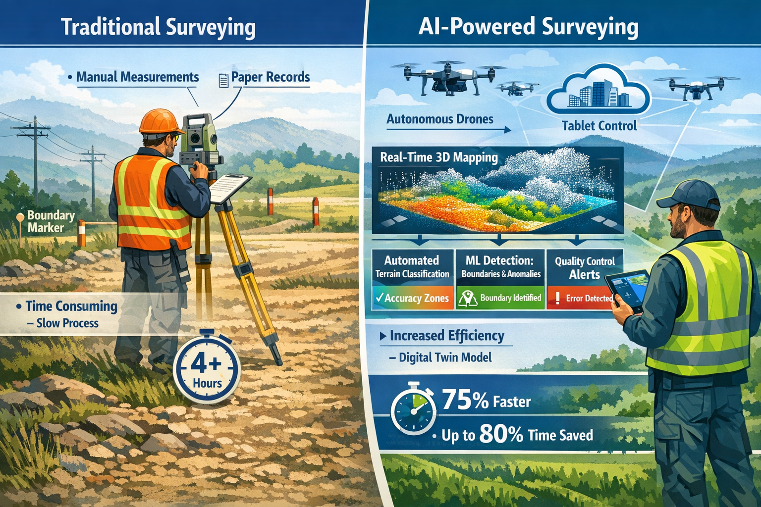
Traditional surveying workflows relied heavily on manual data collection, human interpretation, and sequential processing stages. Surveyors would visit sites multiple times, manually record measurements, return to the office for data processing, and spend days or weeks analyzing information before delivering final reports.
AI-driven surveying workflows in 2026 operate fundamentally differently. Machine learning algorithms now process massive datasets rapidly, identifying patterns, detecting changes, and even predicting future developments—all while significantly reducing the time needed for data analysis.[2] Rather than serving as an add-on tool, AI is integrated at every stage:
- Data capture: Autonomous systems adjust sensor settings in real-time based on environmental conditions
- Processing: Algorithms automatically classify terrain features, vegetation, structures, and boundaries
- Quality control: AI systems flag anomalies and inconsistencies before human review
- Analysis: Machine learning identifies patterns and trends across historical and current data
- Delivery: Automated report generation with AI-assisted visualization
The Core Technologies Powering the Revolution
Several converging technologies enable AI-driven precision in modern surveying:
| Technology | Function | Impact on Workflows |
|---|---|---|
| Machine Learning Algorithms | Pattern recognition, classification, prediction | 70-80% reduction in manual data processing time |
| Computer Vision | Automated feature identification and measurement | Eliminates manual marker identification errors |
| Neural Networks | Complex terrain modeling and change detection | Enables predictive analysis of environmental changes |
| Cloud Computing | Real-time data processing and collaboration | Instant access to processed data from field locations |
| Edge AI | On-device processing in field equipment | Immediate feedback and quality validation during capture |
These technologies work together seamlessly. For example, when a surveyor deploys an autonomous drone, edge AI processes initial data on the device itself, computer vision identifies features in real-time, machine learning algorithms classify terrain automatically, and cloud computing enables instant synchronization with office systems—all without manual intervention.[1]
Professionals seeking to understand the broader context of modern surveying practices can explore our comprehensive guide on comparing different types of survey methodologies.
How AI Transforms Core Surveying Processes
The practical implementation of AI-Driven Precision in Land Surveying: Revolutionizing Workflows in 2026 extends across every major surveying function. Understanding these specific transformations helps professionals identify opportunities for adoption within their own practices.
Automated Terrain Classification and Feature Recognition
One of the most significant workflow improvements comes from AI's ability to automatically classify terrain features and recognize boundaries, structures, and markers without human intervention. Traditional surveying required professionals to manually identify and categorize every feature captured in field data—a time-consuming and error-prone process.
In 2026, computer vision algorithms trained on millions of surveying images can instantly recognize:
- Property boundaries and corner markers
- Vegetation types and density patterns
- Built structures and infrastructure elements
- Geological features and terrain classifications
- Utility lines and underground infrastructure indicators
- Erosion patterns and soil composition changes
This automated classification happens in real-time during data capture. AI systems embedded directly into surveying workflows alert surveyors to inconsistencies before projects reach the drafting stage, enhancing accuracy standards significantly.[1] When the system identifies a potential boundary marker, it automatically flags it for verification, cross-references it against property records, and suggests classification based on visual characteristics and location data.
Predictive Modeling and Risk Assessment
Beyond processing current data, AI enables predictive capabilities that fundamentally change how surveyors approach project planning and risk assessment. Machine learning algorithms analyze historical data patterns to forecast future developments, including:
- Flood risk prediction: AI models process topographical data, historical weather patterns, and drainage characteristics to predict flooding potential with unprecedented accuracy[2]
- Landslide susceptibility: Algorithms identify slope instability indicators and predict high-risk areas before visible signs emerge
- Infrastructure stress analysis: AI predicts structural stress points and maintenance needs based on load patterns and environmental factors
- Vegetation growth modeling: Machine learning forecasts landscape changes to inform long-term development planning
- Soil settlement prediction: Algorithms analyze subsidence patterns to predict future ground movement
These predictive tools remain in early development stages but show promising potential for environmental and construction monitoring.[2] For projects requiring detailed structural analysis, professionals can leverage specialized services like structural surveys that incorporate these advanced predictive technologies.
AI-Assisted Quality Control and Error Detection
Quality assurance has historically been one of the most labor-intensive aspects of surveying work. Human reviewers would manually check measurements, verify calculations, and cross-reference data points—a process that could take days or weeks for complex projects.
AI-assisted quality checks are now integrated into review pipelines, providing several critical advantages:
✅ Instant anomaly detection: Algorithms identify measurements that fall outside expected parameters immediately during data capture
✅ Consistency verification: AI cross-references new data against historical surveys, property records, and adjacent parcels to identify discrepancies
✅ Measurement validation: Machine learning models verify that distances, angles, and elevations align with physical constraints and mathematical relationships
✅ Completeness checking: Systems automatically identify gaps in data coverage and alert surveyors to missing information before leaving the site
✅ Accuracy scoring: AI assigns confidence levels to measurements based on sensor quality, environmental conditions, and redundancy verification
This integrated quality control means errors are caught and corrected in the field rather than discovered weeks later during office review. The result is dramatically reduced project timelines and virtually eliminated costly resurvey visits.
Real-World Implementation: 2026 Case Studies
Several surveying firms have documented significant improvements from AI integration in 2026:
Large-Scale Agricultural Survey: A surveying company reduced a 500-acre agricultural property assessment from five site visits over three weeks to a single two-hour autonomous drone flight. AI algorithms automatically classified crop types, identified irrigation infrastructure, detected soil composition variations, and generated preliminary boundary recommendations—delivering the complete dataset within 24 hours of field capture.
Urban Infrastructure Assessment: Municipal surveyors using AI-powered road condition analysis processed 150 miles of roadway in one week, with automated detection of road cracks, deteriorating guard rails, and damaged traffic signs. This addresses the critical context that 39% of USA roads are currently in poor condition.[3] The AI system prioritized repair needs based on severity and traffic volume, enabling data-driven maintenance budgeting.
Commercial Development Site Analysis: A development project requiring detailed topographical analysis, environmental assessment, and utility mapping was completed in 40% less time using AI-driven workflows. The system automatically identified wetland boundaries, classified vegetation for environmental compliance, detected underground utility indicators, and generated multiple development scenario models—all from a single comprehensive data capture session.
These real-world implementations demonstrate that AI-driven precision isn't a future possibility—it's delivering measurable value in 2026 surveying projects today.
Autonomous Drones and Multi-Sensor Integration
The convergence of autonomous drone technology and AI-driven sensor integration represents perhaps the most visible transformation in land surveying workflows. Drones have transitioned from prohibitively expensive specialty tools to standard equipment for many surveying tasks, becoming significantly cheaper and more accessible to surveying firms.[2]
Multi-Sensor Autonomous Systems
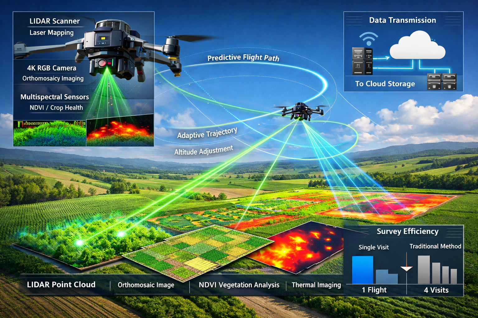
Modern surveying drones in 2026 carry synchronized sensor arrays that capture multiple data types simultaneously during a single flight. This multi-sensor integration eliminates the need for multiple site visits and provides comprehensive datasets that would have required separate specialized equipment previously.[1]
Typical 2026 surveying drone sensor configuration:
🔹 LiDAR scanners: Capture precise three-dimensional point clouds with centimeter-level accuracy, penetrating vegetation to reveal ground surface topology
🔹 High-resolution photogrammetry cameras: Generate detailed orthomosaic imagery and texture mapping for visual context and feature identification
🔹 Multispectral sensors: Detect vegetation health, soil moisture content, and material composition through wavelength analysis beyond visible spectrum
🔹 Thermal imaging cameras: Identify temperature variations that indicate drainage patterns, structural defects, or underground features
🔹 GPS/GNSS receivers: Provide precise georeferencing for all captured data with real-time kinematic (RTK) correction
The true innovation lies not just in carrying multiple sensors, but in the AI-powered coordination between them. Machine learning algorithms determine optimal sensor settings based on environmental conditions, automatically adjusting exposure, scan density, flight altitude, and capture angles to maximize data quality.
Autonomous Flight Path Planning
Traditional drone surveying required manual flight planning, with operators pre-programming routes and manually adjusting for obstacles or changing conditions. AI-driven autonomous flight path planning in 2026 uses predictive modeling to automatically adjust altitude, angle, and sensor selection for optimal readings.[1]
The system considers multiple variables simultaneously:
- Terrain complexity: Algorithms adjust flight altitude to maintain consistent ground sampling distance over varying elevations
- Vegetation density: AI determines optimal LiDAR pulse density and flight speed to penetrate canopy coverage
- Lighting conditions: Computer vision assesses sun angle and cloud cover to optimize photogrammetry capture timing
- Regulatory constraints: Systems automatically incorporate no-fly zones, altitude restrictions, and airspace requirements
- Battery optimization: Machine learning calculates most efficient flight paths to maximize coverage per battery cycle
This autonomous capability expands practical applications for large agricultural, commercial, and development-scale properties where manual flight planning would be prohibitively time-consuming.[1] A surveyor can simply define the project boundary, specify required data types, and allow the AI system to determine optimal capture strategy.
Single-Flight Comprehensive Data Capture
The combination of multi-sensor arrays and autonomous flight planning enables single-flight comprehensive surveys that previously required multiple specialized site visits. This workflow transformation delivers several critical advantages:
Time efficiency: What once required three to five separate site visits with different equipment configurations now completes in a single two-to-four-hour flight session.
Data consistency: All sensor data is captured simultaneously under identical environmental conditions, eliminating temporal variations that could affect analysis.
Cost reduction: Reduced site visits translate directly to lower travel costs, reduced labor hours, and faster project completion.
Safety improvement: Fewer site visits mean reduced exposure to hazardous terrain, traffic, or adverse weather conditions.
Client satisfaction: Dramatically shortened project timelines enable faster decision-making for development, construction, and transaction processes.
For professionals working on commercial property surveying projects, these multi-sensor drone capabilities enable comprehensive site analysis that supports both immediate assessment needs and long-term development planning.
Integration with Ground-Based Surveying
While autonomous drones provide exceptional aerial perspective and broad coverage, AI-driven precision in 2026 also enhances traditional ground-based surveying equipment. Modern total stations and GPS receivers now incorporate machine learning algorithms that:
- Automatically identify and lock onto survey markers and control points
- Adjust measurement parameters based on atmospheric conditions
- Detect and compensate for environmental interference
- Cross-validate measurements against multiple reference systems
- Suggest optimal measurement positions for maximum accuracy
The most effective surveying workflows in 2026 combine autonomous aerial data capture with AI-enhanced ground verification, creating comprehensive datasets with redundant validation that ensures exceptional accuracy.
Real-Time 3D Digital Twins and Cloud Collaboration
Perhaps the most transformative aspect of AI-Driven Precision in Land Surveying: Revolutionizing Workflows in 2026 is the shift from static deliverables to dynamic, interactive models. The emergence of real-time 3D digital twins fundamentally changes how surveyors, clients, and project stakeholders interact with spatial data.
Understanding Real-Time Digital Twins
A digital twin is a high-fidelity, interactive three-dimensional model that updates continuously as new data is collected. Unlike traditional survey deliverables—static PDF reports, CAD drawings, or fixed 3D models—digital twins are living representations that evolve throughout a project's lifecycle.[1]
Key characteristics of 2026 surveying digital twins:
📍 Continuous updates: Models automatically incorporate new data from ongoing monitoring, periodic resurveys, or construction progress documentation
📍 Multi-layered information: Users can toggle between topographical data, utility infrastructure, vegetation analysis, ownership boundaries, and environmental factors
📍 Interactive analysis: Stakeholders can manipulate the model to test scenarios, measure distances, calculate volumes, and visualize proposed changes
📍 Historical comparison: Time-slider functionality enables comparison between survey dates to identify changes and track development
📍 Integrated documentation: Photos, notes, compliance documents, and technical specifications link directly to relevant model locations
Predictive Simulation Capabilities
The true power of AI-driven digital twins extends beyond visualization to predictive simulation. Machine learning algorithms analyze the model's data to project future scenarios and test hypothetical conditions:
Slope erosion projections: AI models simulate rainfall patterns and soil characteristics to predict erosion progression over months or years, enabling proactive mitigation planning.
Water flow simulations: Algorithms calculate drainage patterns under various precipitation scenarios, identifying potential flooding areas and optimal stormwater management solutions.
Vegetation pattern changes: Machine learning forecasts plant growth, succession patterns, and landscape evolution to inform long-term site planning.
Infrastructure stress testing: AI simulates structural loads, environmental stresses, and usage patterns to predict maintenance needs and identify potential failure points before they occur.
These simulations provide actionable intelligence that transforms surveying from documentation of current conditions to strategic planning tools for future development. Property owners considering building surveys can benefit from these predictive capabilities to understand long-term property maintenance and development potential.
Cloud-Based Collaboration Platforms
The shift to cloud-based platforms represents a fundamental change in how surveying data is shared and utilized. Traditional surveying workflows delivered static documents via email or file transfer, creating version control challenges and limiting real-time collaboration.
Cloud platforms in 2026 enable:
✨ Instant file sharing: Survey data uploads automatically to secure cloud storage accessible to authorized stakeholders immediately upon processing
✨ 3D browser visualization: Clients, engineers, and architects view and interact with full 3D models directly in web browsers without specialized software
✨ Real-time revision syncing: Changes made by any team member propagate instantly to all users, eliminating version confusion
✨ Integrated communication: Comments, questions, and annotations attach directly to specific model locations, creating contextual conversation threads
✨ Permission-based access: Granular security controls ensure each stakeholder sees only relevant information appropriate to their role
✨ Mobile accessibility: Field teams access complete project data on tablets and smartphones, enabling informed decision-making at the site
This cloud-based collaboration model replaces the static document delivery approach that dominated surveying for decades.[1] Instead of waiting days or weeks for report delivery, stakeholders engage with survey data within hours of field capture, accelerating project timelines and enabling more informed decision-making.
Integration with Design and Construction Workflows
The most significant value of real-time digital twins emerges when surveying data integrates seamlessly with design and construction workflows. In 2026, AI-driven interoperability enables:
- Automatic BIM integration: Survey data flows directly into Building Information Modeling (BIM) platforms, providing accurate as-built conditions for design teams
- Construction progress monitoring: Periodic resurveys automatically compare current site conditions against design models, identifying deviations and tracking completion
- Clash detection: AI algorithms identify conflicts between existing conditions and proposed designs before construction begins
- Quantity verification: Machine learning calculates material volumes, cut-and-fill requirements, and resource needs directly from survey models
- Regulatory compliance documentation: Automated reports demonstrate adherence to setback requirements, environmental restrictions, and zoning regulations
This integration eliminates the traditional disconnect between surveying, design, and construction phases. Data flows seamlessly between disciplines, reducing errors, preventing rework, and accelerating project delivery.
For professionals managing complex projects, specialized services like monitoring surveys leverage these digital twin capabilities to track changes over time and ensure construction proceeds according to design specifications.
Overcoming Adoption Challenges and Future Outlook
While the benefits of AI-Driven Precision in Land Surveying: Revolutionizing Workflows in 2026 are substantial, the architecture, engineering, and construction sector remains slow to adapt AI overall.[5][6] Understanding the barriers to adoption and strategies for successful implementation is critical for surveying professionals navigating this transition.
Current Adoption Barriers
Several factors contribute to slower-than-expected AI adoption across the surveying profession:
💼 Initial investment costs: While drone technology has become more affordable, comprehensive AI-driven surveying systems still require significant capital investment in hardware, software licenses, and cloud infrastructure.
📚 Skills gap: Many experienced surveyors lack training in AI technologies, machine learning concepts, and advanced data analysis techniques required to fully leverage these tools.
⚖️ Regulatory uncertainty: Evolving regulations around drone operations, data privacy, and AI-generated deliverables create hesitation among firms concerned about compliance.
🔒 Data security concerns: Cloud-based workflows raise questions about data ownership, security, and confidentiality—particularly for sensitive government or private development projects.
🤝 Client education: Many clients remain unfamiliar with digital twin deliverables and interactive models, preferring traditional report formats they understand.
⏰ Change management resistance: Established firms with decades of successful traditional workflows may resist fundamental process changes despite demonstrated benefits.
Strategies for Successful Implementation
Surveying firms successfully adopting AI-driven workflows in 2026 share several common strategies:
Start with pilot projects: Implement AI technologies on smaller, lower-risk projects to build experience and demonstrate value before scaling to major assignments.
Invest in training: Provide comprehensive education for staff on AI concepts, new software platforms, and updated workflows—treating this as essential professional development rather than optional enhancement.
Partner with technology providers: Establish relationships with AI platform vendors who provide implementation support, training resources, and ongoing technical assistance.
Develop hybrid workflows: Combine traditional methods with AI-enhanced processes, allowing gradual transition rather than disruptive complete replacement of established procedures.
Document ROI metrics: Track measurable improvements in project timelines, accuracy rates, client satisfaction, and profitability to justify continued investment and expansion.
Engage clients early: Educate clients about new deliverable formats and capabilities during project scoping, demonstrating value and setting appropriate expectations.
Firms offering comprehensive services like RICS building surveys can leverage AI capabilities to enhance traditional deliverables while maintaining professional standards and client confidence.
The 94% Momentum: Industry Trajectory
Despite overall slow sector adaptation, the trajectory for AI adoption in surveying is remarkably positive. According to an ASCE survey, 94% of surveying and construction professionals who currently use AI plan to increase their AI usage in 2026.[5] This statistic reveals critical insights:
Early adopters are experiencing success: The overwhelming majority planning to expand AI usage indicates these technologies are delivering measurable value, not disappointing early implementations.
Competitive pressure is building: As leading firms demonstrate faster delivery, higher accuracy, and enhanced capabilities, competitors face increasing pressure to adopt similar technologies or risk losing market share.
Client expectations are evolving: Property owners, developers, and municipalities increasingly expect modern deliverables like interactive 3D models and predictive analysis rather than traditional static reports.
Technology maturity is improving: AI platforms specifically designed for surveying applications are becoming more user-friendly, affordable, and reliable—reducing implementation barriers.
The 27% current adoption rate among survey respondents[5] represents the early majority phase of technology adoption. Historical patterns suggest this will accelerate rapidly as success stories proliferate and competitive pressures intensify.
Emerging Technologies on the Horizon
Looking beyond 2026, several emerging technologies promise to further revolutionize AI-driven surveying:
Quantum computing applications: Future quantum processors could enable real-time processing of massive point cloud datasets that currently require hours of computational time.
Advanced neural networks: Next-generation AI models will provide even more sophisticated pattern recognition, enabling automated detection of subtle defects, boundary disputes, or environmental changes invisible to current systems.
Augmented reality integration: AR headsets will overlay digital twin data onto physical environments in real-time, enabling field surveyors to visualize underground utilities, property boundaries, and design proposals while standing on site.
Satellite-based continuous monitoring: Low-orbit satellite constellations with advanced sensors will enable automated change detection and continuous monitoring without drone deployment.
Blockchain verification: Distributed ledger technology will provide immutable verification of survey data authenticity, timestamp documentation, and chain-of-custody tracking for legal applications.
Professional Development and Career Evolution
The rise of AI-driven precision fundamentally changes the surveying profession itself. Rather than replacing surveyors, AI technologies are elevating the role from data collection technicians to strategic advisors and analytical experts.
Modern surveyor skillsets in 2026 include:
- Traditional surveying fundamentals and measurement principles
- AI and machine learning concept understanding
- Data analysis and statistical interpretation
- Cloud platform management and digital collaboration
- Client consultation and strategic planning
- Regulatory compliance and legal documentation
- Technology integration and workflow optimization
Surveying professionals who embrace continuous learning and develop expertise in AI-enhanced workflows position themselves for career advancement and increased value to clients. Those who resist adaptation face increasing obsolescence as client expectations and competitive standards evolve.
For professionals seeking to understand how modern surveying integrates with broader property assessment, exploring resources on RICS home survey standards provides valuable context for maintaining professional excellence while adopting new technologies.
Practical Implementation Guide for Surveying Firms
For surveying professionals ready to embrace AI-Driven Precision in Land Surveying: Revolutionizing Workflows in 2026, a structured implementation approach maximizes success while minimizing disruption to existing operations.
Phase 1: Assessment and Planning (Months 1-2)
Evaluate current workflows: Document existing processes, identifying bottlenecks, error-prone stages, and time-intensive manual tasks that AI could address.
Define objectives: Establish specific, measurable goals such as "reduce project turnaround time by 40%" or "eliminate resurvey visits by 80%."
Research technology options: Evaluate AI platforms, drone systems, and cloud collaboration tools specifically designed for surveying applications.
Calculate investment requirements: Develop comprehensive budget including hardware, software licenses, training costs, and implementation support.
Assess team readiness: Identify skills gaps and training needs among current staff members.
Phase 2: Pilot Implementation (Months 3-6)
Select pilot projects: Choose 2-3 smaller projects that represent typical work but aren't mission-critical to test new workflows.
Acquire core technology: Purchase essential equipment and software licenses needed for pilot implementation.
Conduct intensive training: Provide hands-on education for staff who will operate new systems and analyze AI-generated data.
Implement hybrid workflows: Use AI-enhanced methods alongside traditional verification to build confidence and validate accuracy.
Document results meticulously: Track time savings, accuracy improvements, client feedback, and lessons learned.
Phase 3: Refinement and Scaling (Months 7-12)
Analyze pilot outcomes: Review documented results against initial objectives, identifying successful elements and areas needing adjustment.
Refine workflows: Modify processes based on pilot experience to optimize efficiency and accuracy.
Expand technology deployment: Acquire additional equipment and licenses to support broader implementation.
Train additional staff: Extend education programs to all team members who will interact with new systems.
Update client communication: Develop materials explaining new deliverable formats and enhanced capabilities.
Scale to production projects: Apply AI-enhanced workflows to standard project portfolio while maintaining quality controls.
Phase 4: Optimization and Innovation (Ongoing)
Monitor performance metrics: Continuously track key performance indicators including project timelines, accuracy rates, and client satisfaction.
Stay current with technology: Regularly evaluate emerging AI capabilities and platform updates that could further enhance workflows.
Invest in advanced training: Provide ongoing professional development to deepen staff expertise in AI technologies and data analysis.
Innovate service offerings: Develop new service packages leveraging AI capabilities such as predictive monitoring, continuous digital twin updates, or environmental change tracking.
Share success stories: Document case studies and client testimonials demonstrating value delivered through AI-enhanced surveying.
This phased approach enables surveying firms to adopt AI technologies methodically while maintaining service quality and client confidence throughout the transition.
Industry-Specific Applications and Use Cases

AI-Driven Precision in Land Surveying: Revolutionizing Workflows in 2026 delivers value across diverse surveying specializations. Understanding industry-specific applications helps professionals identify relevant opportunities within their practice areas.
Residential Property Surveying
For residential applications, AI-enhanced surveying provides:
- Rapid boundary verification: Automated comparison of current measurements against property records and adjacent parcel data
- Defect detection: Computer vision algorithms identify structural issues, drainage problems, and maintenance needs during visual inspection
- Predictive maintenance: Machine learning forecasts repair timelines and cost projections based on current condition assessment
- Environmental risk assessment: AI analysis of topography, drainage, and vegetation to identify flood risk, erosion potential, or foundation concerns
Homebuyers and property owners benefit from faster turnaround times and more comprehensive analysis. Professionals can explore how these capabilities enhance traditional RICS building surveys Level 3 deliverables.
Commercial and Industrial Development
Large-scale commercial projects leverage AI capabilities for:
- Site feasibility analysis: Automated evaluation of multiple development scenarios with grading requirements, drainage solutions, and infrastructure needs
- Environmental compliance: Machine learning classification of wetlands, protected habitats, and sensitive areas requiring regulatory consideration
- Utility mapping: AI-enhanced detection of underground infrastructure using ground-penetrating radar and predictive modeling
- Progress monitoring: Continuous comparison of construction advancement against design models with automated deviation alerts
Agricultural and Rural Land Assessment
Agricultural applications benefit significantly from multi-sensor drone integration:
- Crop health monitoring: Multispectral analysis identifying irrigation issues, pest damage, or nutrient deficiencies
- Soil composition mapping: AI classification of soil types and characteristics across large properties
- Drainage planning: Automated modeling of water flow patterns and optimal drainage system design
- Yield prediction: Machine learning analysis of vegetation health, historical data, and environmental factors to forecast production
Infrastructure and Transportation
Municipal and transportation surveyors use AI for:
- Road condition assessment: Automated detection and classification of pavement defects, requiring immediate attention given that 39% of USA roads are in poor condition[3]
- Bridge inspection: Computer vision analysis of structural elements identifying cracks, corrosion, and deterioration
- Traffic flow optimization: Predictive modeling of congestion patterns and infrastructure capacity
- Utility corridor monitoring: Continuous assessment of power lines, pipelines, and communication infrastructure
Environmental and Conservation Projects
Environmental surveying applications include:
- Habitat mapping: Automated classification of vegetation types, wildlife corridors, and ecosystem boundaries
- Erosion monitoring: Time-series analysis detecting landscape changes and predicting future degradation
- Wetland delineation: AI-assisted identification of jurisdictional boundaries based on vegetation, hydrology, and soil characteristics
- Climate impact assessment: Predictive modeling of sea-level rise, temperature changes, and precipitation pattern effects on landscapes
Each specialization benefits from AI's ability to process complex datasets rapidly, identify subtle patterns, and generate predictive insights that inform strategic decision-making.
Conclusion: Embracing the AI-Driven Future
AI-Driven Precision in Land Surveying: Revolutionizing Workflows in 2026 represents far more than technological novelty—it marks a fundamental evolution in how surveying professionals serve clients, deliver value, and contribute to the built environment. The integration of artificial intelligence into core surveying processes is not displacing human expertise but rather amplifying it, enabling surveyors to focus on strategic analysis, client consultation, and complex problem-solving while AI handles routine data processing and quality verification.
The evidence is compelling: 94% of surveying professionals currently using AI plan to increase their adoption in 2026,[5] autonomous multi-sensor drones eliminate multiple site visits through comprehensive single-flight data capture,[1] real-time digital twins enable predictive simulations and cloud-based collaboration,[1] and AI-assisted quality control catches errors before they impact project timelines.[1] These aren't theoretical benefits—they're delivering measurable value in real-world implementations today.
The surveying profession stands at a crossroads. Firms that embrace AI-driven workflows position themselves as industry leaders, delivering faster turnaround times, higher accuracy, enhanced capabilities, and superior client value. Those that resist adaptation risk falling behind as client expectations evolve and competitive pressures intensify.
Actionable Next Steps
For surveying professionals ready to embrace this transformation:
1. Educate yourself: Invest time understanding AI concepts, machine learning fundamentals, and available surveying-specific platforms. Knowledge reduces implementation anxiety and enables informed technology selection.
2. Start small: Identify a single workflow bottleneck or pain point that AI could address. Implement a focused solution rather than attempting comprehensive transformation simultaneously.
3. Prioritize training: Treat AI education as essential professional development for yourself and your team. Technology is only valuable when users understand how to leverage it effectively.
4. Engage with peers: Join professional organizations, attend industry conferences, and participate in forums where early adopters share experiences and lessons learned.
5. Communicate with clients: Proactively educate clients about new capabilities and deliverable formats. Position AI-enhanced services as value-added offerings rather than cost increases.
6. Monitor industry developments: Stay informed about emerging technologies, regulatory changes, and evolving best practices through professional publications and continuing education.
7. Measure and document: Track specific metrics demonstrating AI's impact on your workflows. Data-driven evidence supports continued investment and helps market enhanced capabilities to clients.
The revolution in land surveying is underway. The question is not whether AI will transform surveying workflows, but rather how quickly individual professionals and firms will adapt to capture the competitive advantages these technologies provide. Those who act decisively in 2026 will define industry standards for the decade ahead.
For surveying professionals seeking comprehensive guidance on modern surveying practices and standards, consulting with RICS-certified experts ensures implementation aligns with professional best practices and regulatory requirements.
The future of land surveying is intelligent, automated, predictive, and collaborative. The tools to participate in this future are available today. The only remaining question is: will you lead the transformation or follow it?
References
[1] Future Land Surveying 2026 – https://haller-blanchard.com/future-land-surveying-2026/
[2] The Future Of Land Surveying Technology And Upcoming Trends In 2026 – https://metricop.com/blogs/land-surveying/the-future-of-land-surveying-technology-and-upcoming-trends-in-2026
[3] How Ai Is Changing The Role Of The Surveyor In Aec – https://www.gim-international.com/content/article/how-ai-is-changing-the-role-of-the-surveyor-in-aec
[4] Top Emerging Land Surveying Technologies Shaping 2026 Drones Ai And Beyond – https://nottinghillsurveyors.com/blog/top-emerging-land-surveying-technologies-shaping-2026-drones-ai-and-beyond
[5] Architecture Engineering Construction Sector Slow To Adapt Ai Survey Shows – https://www.asce.org/publications-and-news/civil-engineering-source/article/2025/12/18/architecture-engineering-construction-sector-slow-to-adapt-ai-survey-shows
[6] Doubling Down On Digital – https://amerisurv.com/2026/02/01/doubling-down-on-digital/