By 2026, over 70% of global land management decisions are informed by geospatial data — yet a significant number of surveyors still treat Geographic Information Systems (GIS) as a back-office tool rather than the strategic engine it has become. That gap is costing professionals real opportunities in two of the fastest-growing sectors: precision agriculture and urban development planning.
This tutorial-style guide on GIS Mastery for Surveyors: Unlocking Precision Farming and Urban Planning Applications in 2026 breaks down how to centralize geospatial data, spot land-use trends, and translate raw spatial information into actionable visuals — whether you are managing crop fields or city blocks.

Key Takeaways 📌
- GIS is no longer optional for surveyors — it is the central nervous system of modern land assessment in both agriculture and urban planning.
- Centralizing geospatial data from multiple sources (drones, satellites, sensors) is the first and most critical step toward meaningful analysis.
- Mobile mapping integration turns static GIS databases into real-time, field-ready tools that support faster, more accurate decisions.
- Land-use trend analysis powered by GIS gives surveyors a competitive edge in advising clients on development potential and agricultural yield optimization.
- Surveyors who combine GIS skills with traditional chartered expertise are positioned as high-value consultants in 2026's data-driven property and land markets.
What Is GIS and Why Does It Matter for Surveyors in 2026?
Geographic Information Systems (GIS) are software platforms that capture, store, analyze, and visualize spatial and geographic data. For surveyors, GIS is the bridge between raw field measurements and meaningful, decision-ready intelligence.
In 2026, the surveying profession sits at an exciting crossroads. Traditional measurement skills remain essential, but clients — from farmers to city councils — increasingly demand data-rich reports that go beyond boundary lines and building conditions. They want to understand:
- How land is currently being used 🌾🏙️
- How it could be used more efficiently
- What trends are emerging in the surrounding area
- How infrastructure, soil quality, or zoning changes affect value
GIS answers all of these questions. Platforms like Esri ArcGIS, QGIS (open-source), and Trimble Business Center allow surveyors to layer multiple data types — topography, soil composition, satellite imagery, planning boundaries, and utility networks — into a single, interactive map.
💬 "GIS transforms a surveyor from a data collector into a data interpreter — and that distinction is worth a premium in any market."
For surveyors already offering services like monitoring surveys or drone surveys, GIS integration is a natural and powerful next step.
Step 1 — Centralizing Geospatial Data: The Foundation of GIS Mastery for Surveyors

The most common mistake surveyors make when adopting GIS is treating it as just another mapping tool. True GIS mastery begins with data centralization — pulling every relevant spatial dataset into one unified environment.
Key Data Sources to Integrate
| Data Type | Source | Application |
|---|---|---|
| Satellite imagery | Copernicus, Maxar, Planet Labs | Land cover classification, change detection |
| LiDAR point clouds | Aerial surveys, drone scans | Terrain modeling, building footprints |
| Soil sensor readings | IoT field sensors | Precision agriculture planning |
| Cadastral boundaries | Land Registry, OS MasterMap | Property and planning analysis |
| Weather/climate data | Met Office, NOAA APIs | Crop yield prediction, flood risk |
| Infrastructure layers | Local authority GIS portals | Urban development feasibility |
How to Build a Centralized GIS Database
- Choose a coordinate reference system (CRS) — In the UK, OSGB 1936 / British National Grid (EPSG:27700) is standard. Consistency here prevents costly alignment errors.
- Establish a data schema — Define layer naming conventions, attribute fields, and metadata standards before importing anything.
- Use a geodatabase format — Esri's File Geodatabase or a PostGIS/PostgreSQL database handles large datasets far better than shapefiles.
- Automate data ingestion — Set up scheduled imports from APIs (satellite feeds, weather services) so your GIS stays current without manual effort.
- Apply data quality checks — Validate geometry, check for null values, and cross-reference overlapping layers.
This structured approach is especially valuable when producing detailed assessments like stock condition surveys or schedule of condition reports, where spatial accuracy directly affects legal and financial outcomes.
Step 2 — Spotting Land-Use Trends with GIS Analysis
Once data is centralized, the analytical power of GIS becomes clear. Land-use trend analysis is one of the most commercially valuable skills a surveyor can develop in 2026.
Techniques for Land-Use Analysis
🔍 Change Detection Analysis
By comparing satellite or aerial imagery from different time periods, surveyors can identify:
- Agricultural land being converted to residential or commercial use
- Urban sprawl encroaching on green belt areas
- Deforestation or soil degradation patterns
- Infrastructure development corridors
📊 Spatial Statistics
Tools like kernel density estimation, spatial autocorrelation (Moran's I), and hotspot analysis reveal clusters of activity — for example, where new housing developments are concentrating, or where crop yields are consistently underperforming.
🗺️ Overlay Analysis
Stacking multiple layers — zoning maps, flood risk zones, transport accessibility, soil classification — allows surveyors to produce composite suitability maps that answer specific client questions:
- "Where on this 500-acre estate is precision irrigation most cost-effective?"
- "Which parcels in this urban fringe zone have the highest development potential?"
Time-Series Modeling
Using historical land-use data, GIS platforms can project future trends. This is particularly powerful for urban planners and agricultural advisors who need to make long-term investment decisions.
💬 "The surveyor who can show a client not just where they are, but where they are heading — that surveyor becomes indispensable."
Understanding factors of valuation becomes far more nuanced when spatial trend data is layered into the assessment process.
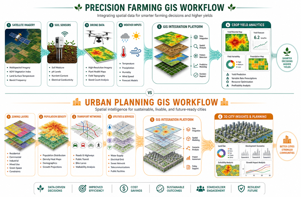
Step 3 — GIS for Precision Farming: From Data to Crop Intelligence

Precision agriculture is one of the most exciting applications of GIS Mastery for Surveyors: Unlocking Precision Farming and Urban Planning Applications in 2026. The core principle is simple: apply the right input, in the right place, at the right time — and GIS is the tool that makes this possible at scale.
Core GIS Applications in Precision Farming
Variable Rate Application (VRA) Mapping
By combining soil sample data, yield history, and satellite-derived vegetation indices (NDVI — Normalized Difference Vegetation Index), surveyors can create prescription maps that guide variable-rate fertilizer, seed, and irrigation applications. This reduces input costs and environmental impact simultaneously.
Soil Health Mapping
GIS integrates data from:
- Electromagnetic induction (EMI) surveys
- Ground-penetrating radar (GPR)
- Laboratory soil analysis
These layers reveal spatial variability in soil texture, pH, organic matter, and compaction — information that directly drives management zone decisions.
Drone Integration for Crop Monitoring
Drone surveys have become a standard tool for agricultural surveyors. When drone-captured multispectral imagery is processed and loaded into GIS:
- Crop stress areas become visible weeks before visible symptoms appear
- Weed pressure maps guide targeted herbicide application
- Irrigation inefficiencies are identified spatially
Yield Mapping
GPS-enabled combine harvesters generate point-cloud yield data that, when imported into GIS and interpolated, creates yield maps. Year-on-year comparison of these maps reveals persistent underperforming zones that warrant investigation.
Precision Farming GIS Workflow — Summary
Field Data Collection (drones, sensors, GPS)
        ↓
Data Centralization (GIS geodatabase)
        ↓
Spatial Analysis (NDVI, soil variability, yield history)
        ↓
Prescription Map Generation
        ↓
Variable Rate Application / Management Decision
        ↓
Outcome Monitoring & Model Refinement
Step 4 — GIS for Urban Planning: Turning Spatial Data into City Intelligence
Urban planning is the other major frontier for GIS Mastery for Surveyors: Unlocking Precision Farming and Urban Planning Applications in 2026. As cities grow and planning systems become more data-driven, surveyors with GIS expertise are increasingly sought after by local authorities, developers, and infrastructure agencies.
Key Urban Planning GIS Applications
🏗️ Development Feasibility Analysis
GIS layers planning policy zones, flood risk areas, transport accessibility scores, and infrastructure capacity onto a single map. Surveyors can rapidly identify which land parcels are viable for development and what constraints apply — information that feeds directly into commercial property surveying and valuation work.
🚇 Transport and Accessibility Modeling
Network analysis tools within GIS calculate travel times, catchment areas, and service coverage. This is essential for:
- Retail location analysis
- School and healthcare facility planning
- Public transport route optimization
💧 Infrastructure and Utilities Mapping
Centralizing utility network data (water, gas, electricity, drainage) within GIS prevents costly clashes during development and supports drainage survey planning and groundwater sampling assessments.
🌳 Green Infrastructure Planning
Urban GIS increasingly incorporates tree canopy data, biodiversity net gain mapping, and urban heat island analysis — all critical for sustainable city development in 2026.
3D City Modeling
Modern GIS platforms support CityGML and BIM integration, enabling surveyors to build 3D models of urban environments that simulate shadow impact, wind flow, and visual impact of proposed developments.
Urban Planning GIS — Data Layers Checklist ✅
- OS MasterMap Topography Layer
- Local Planning Authority (LPA) zoning boundaries
- Environment Agency flood risk zones (Flood Zones 1, 2, 3)
- Listed buildings and conservation area boundaries
- Transport network and PTAL scores
- Population density and demographic data (Census)
- Air quality monitoring data
- Utilities and infrastructure networks
- Tree preservation orders (TPOs)
- Contaminated land registers
Step 5 — Mobile Mapping Integration: Taking GIS into the Field
The final step in achieving true GIS Mastery for Surveyors: Unlocking Precision Farming and Urban Planning Applications in 2026 is mobile mapping integration — connecting the office GIS environment with field operations in real time.
Why Mobile GIS Matters
Static GIS databases are only as good as their last update. In fast-moving environments — whether a growing crop or a construction site — data can become outdated within days. Mobile GIS solves this by enabling:
- Real-time data collection using smartphones, tablets, or ruggedized field devices
- Offline mapping in areas with poor connectivity (common in rural agricultural settings)
- Instant synchronization with the central geodatabase when connectivity is restored
- Augmented reality (AR) overlays that display GIS data layers on top of live camera views
Leading Mobile GIS Tools in 2026
| Tool | Best For | Key Feature |
|---|---|---|
| Esri Field Maps | Enterprise GIS teams | Seamless ArcGIS integration |
| QGIS + QField | Open-source workflows | Free, highly customizable |
| Trimble TerraFlex | High-precision surveying | Sub-metre GPS accuracy |
| Fulcrum | Multi-user data collection | Form-based data entry |
| Mapbox | Custom app development | Developer-friendly APIs |
Practical Mobile Mapping Workflow
- Pre-configure field forms in the office — define what attributes field surveyors need to capture
- Download offline map packages for areas with poor signal
- Collect data in the field — photos, measurements, observations, GPS coordinates
- Sync to central GIS on return or via cellular connection
- Review, validate, and analyze the new data within the main GIS platform
- Generate client-ready outputs — maps, reports, dashboards
This workflow is directly applicable to structural surveys and building surveys, where spatial documentation of defects and conditions adds significant analytical value to traditional reporting.
Building a GIS-Ready Surveying Practice in 2026
Adopting GIS is not just a technical upgrade — it is a business transformation. Here is how to position a surveying practice for GIS-led growth:
Skills Development Roadmap
Foundation Level
- Complete QGIS or ArcGIS online training (Esri's free training library is extensive)
- Understand coordinate systems, projections, and spatial data formats
- Practice basic digitizing, attribute editing, and map layout production
Intermediate Level
- Learn spatial analysis tools: buffers, overlays, network analysis
- Develop proficiency in remote sensing interpretation (satellite/drone imagery)
- Build automated workflows using ModelBuilder (ArcGIS) or QGIS Processing
Advanced Level
- Python scripting for GIS automation (ArcPy, PyQGIS, GeoPandas)
- Machine learning for land classification and predictive modeling
- 3D analysis and BIM/GIS integration
Commercial Positioning
Surveyors who combine GIS expertise with traditional RICS-accredited skills can offer genuinely differentiated services. Understanding which survey best fits a client's needs becomes far more nuanced when spatial data informs the recommendation.
GIS-literate surveyors are increasingly engaged by:
- Agricultural estates and farm management companies
- Local planning authorities and urban development agencies
- Infrastructure and utilities companies
- Environmental consultancies
- Property investment funds
Conclusion: Your GIS Mastery Action Plan for 2026
The opportunity is clear. GIS is the skill set that separates surveyors who report on land from those who interpret it — and in 2026, interpretation is where the value lies.
Here are your actionable next steps:
- ✅ Audit your current data — Identify what spatial data you already collect and how it could be centralized in a GIS environment.
- ✅ Choose a platform — Start with QGIS (free) or invest in ArcGIS if your practice handles enterprise-scale projects.
- ✅ Complete one structured GIS course — Esri's free training or Coursera's GIS specializations are excellent starting points.
- ✅ Pilot one GIS project — Apply GIS to an existing client project: a farm assessment, a development feasibility study, or a monitoring survey.
- ✅ Integrate mobile mapping — Download QField or Esri Field Maps and trial real-time field data collection on your next site visit.
- ✅ Build your output library — Develop a portfolio of GIS-enhanced maps and reports to demonstrate capability to new clients.
- ✅ Stay current — Follow RICS guidance, Esri's annual GIS in Land Management reports, and industry publications to track emerging applications.
GIS Mastery for Surveyors: Unlocking Precision Farming and Urban Planning Applications in 2026 is not a distant aspiration — it is a practical, achievable upgrade that any surveyor can begin this week. The land is speaking through data. The question is whether you have the tools to listen.