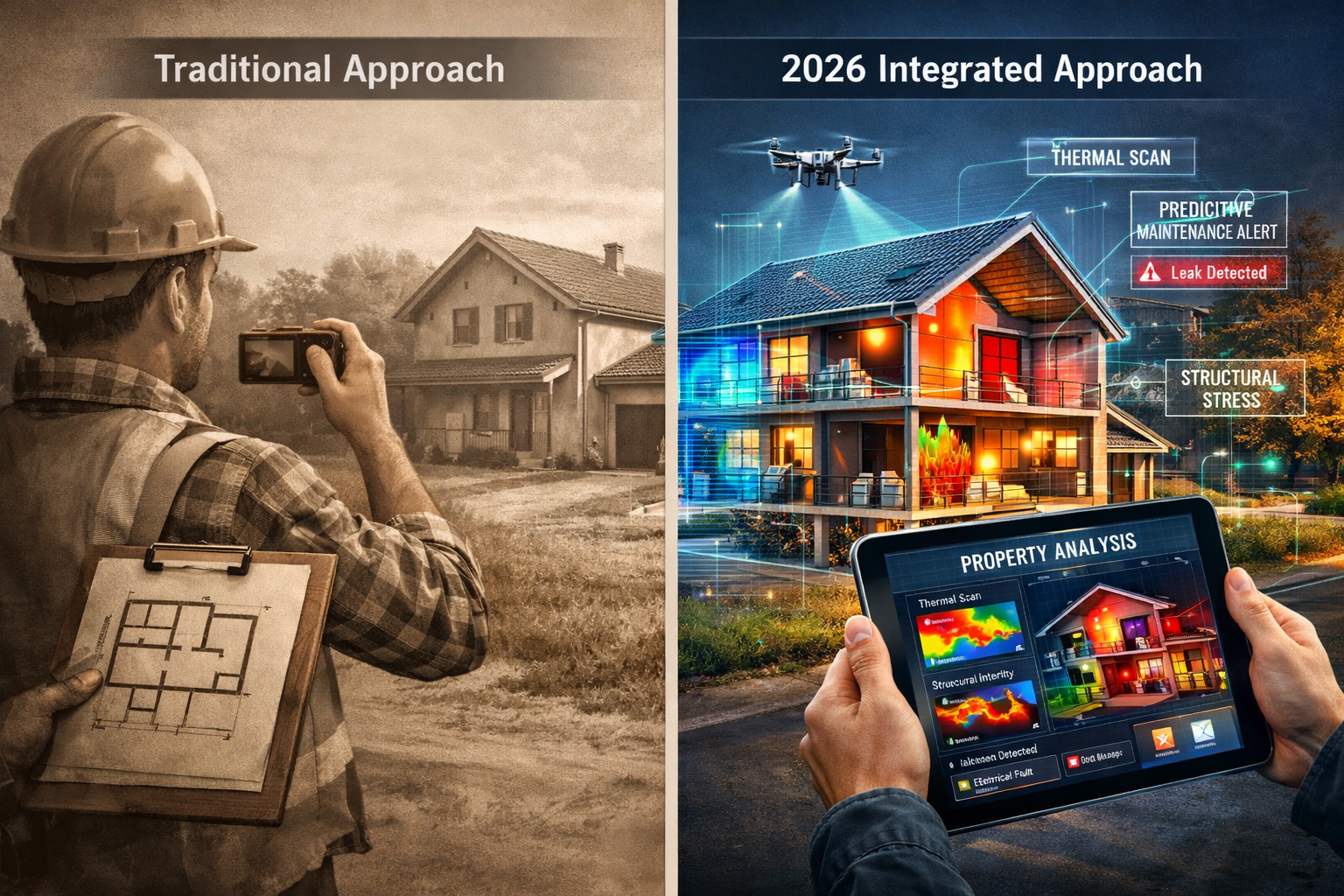
The surveying industry faces a paradox in 2026. Technology has never been more advanced, data collection has never been faster, and digital tools have never been more accessible. Yet many surveyors find themselves drowning in terabytes of information while struggling to deliver the clear, actionable insights that property owners desperately need. Building Survey Technology in 2026: When Data Volume Isn't Insight—Preparing Properties Upfront represents the critical challenge of transforming raw data into meaningful intelligence before valuation routes are chosen and costly decisions are made.
The problem isn't a lack of technology—it's the fragmentation of it. According to recent industry research, data integration has emerged as the top priority for performance improvement in 2026, with contractors reporting that diverse teams using different technology stacks that don't share data are bogging down projects [1]. For surveyors, this means that collecting massive amounts of property data means nothing if that information can't be synthesized into clear recommendations that guide property preparation strategies.

Key Takeaways
- 📊 Data volume doesn't equal insight: Surveyors in 2026 must focus on integrating diverse technology platforms to transform raw data into actionable property intelligence
- 🔗 Integration is the top priority: Research shows that improving how existing technology and data integrate ranks as the initiative with the most potential to improve performance [1]
- 🏗️ Upfront preparation reduces downstream costs: Using advanced survey technology to identify defects and structural issues before valuation routes are chosen prevents expensive surprises later
- 🤖 AI transforms pattern recognition: Machine learning algorithms can now identify structural risks and predict maintenance issues by analyzing historical property data [2]
- 💡 Technology adoption requires strategy: The most successful firms combine advanced tools with workforce training and intuitive adoption strategies to maximize ROI [5]
The Data Deluge Problem: Why More Information Creates Less Clarity
Understanding the Technology Fragmentation Challenge
The modern surveying toolkit in 2026 includes an impressive array of technologies: drone-based photogrammetry, mobile 3D laser scanning, thermal imaging cameras, moisture meters, ground-penetrating radar, and AI-powered defect detection software. Each tool generates its own data format, requires specialized software to interpret, and often operates in isolation from other systems.
A typical building survey might now produce:
- Point cloud data from laser scanning (often 500GB+ per property)
- High-resolution aerial imagery from drone surveys
- Thermal imaging datasets revealing heat loss and moisture intrusion
- Structural analysis reports from specialized software
- Historical records and GIS mapping data
- Manual inspection notes and photographs
The challenge isn't collecting this data—it's synthesizing it into recommendations that property owners can actually use. When a client asks whether they should proceed with a purchase, invest in renovations, or walk away entirely, they need clear answers, not a collection of disconnected reports.
The Cost of Disconnected Data
Industry surveys reveal that 1,800 contractors identified securing employee buy-in and improving technology integration as their top performance improvement initiatives [1]. This fragmentation creates several critical problems:
| Problem | Impact | Solution Required |
|---|---|---|
| Duplicate data collection | Wasted time and increased costs | Unified data capture platforms |
| Inconsistent reporting formats | Client confusion and delayed decisions | Standardized output templates |
| Missed defect correlations | Incomplete risk assessment | AI-powered pattern recognition |
| Slow turnaround times | Lost competitive advantage | Real-time processing workflows |
| Limited historical comparison | Reduced predictive capability | Cloud-based data repositories |
For property owners preparing for RICS building surveys, this fragmentation can mean the difference between identifying a £50,000 structural issue before purchase and discovering it six months after moving in.
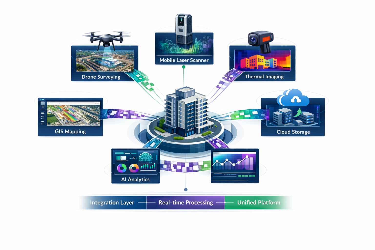
Building Survey Technology in 2026: Integrated Systems That Transform Data Into Decisions
The Rise of Connected Survey Ecosystems
The most successful surveying practices in 2026 have moved beyond collecting data to creating integrated intelligence platforms that automatically correlate findings across multiple data sources. These systems represent a fundamental shift from technology adoption to technology integration.
Geographic Information Systems (GIS) integration has become vital for this transformation. Modern GIS platforms allow surveyors to overlay multiple datasets—zoning information, property boundaries, utility locations, historical flood data, and structural assessments—into single, comprehensive maps that enable better data management and enhanced pattern identification [2].
Key Components of Integrated Survey Systems
1. Mobile 3D Mapping and Reality Capture 📱
Advanced mobile mapping systems now allow surveyors to create detailed 3D models from diverse indoor and outdoor environments without bulky equipment, delivering results in significantly shorter timeframes [2]. These systems integrate seamlessly with:
- Building Information Modeling (BIM) platforms
- Cloud-based collaboration tools
- AI-powered defect detection algorithms
2. AI-Powered Pattern Recognition and Predictive Analytics 🤖
Machine learning algorithms can now process massive datasets to identify patterns in historical data, predicting environmental risks such as flooding and landslides while monitoring structural and terrain changes over time [2]. For commercial building surveys, this means:
- Automated identification of structural stress patterns
- Predictive maintenance scheduling based on material degradation rates
- Risk scoring that prioritizes remediation investments
3. Drone Technology Integration 🚁
The democratization of drone surveys has fundamentally transformed traditional survey methodologies. As unmanned aerial vehicles (UAVs) become more affordable and accessible, their usage in surveying has skyrocketed [2]. Modern drone systems integrate with:
- Automated flight planning software
- Real-time 3D model generation
- Thermal and multispectral imaging analysis
4. Computer Vision for Safety and Defect Detection 👁️
Safety-focused computer vision technologies can now identify hazards in seconds, improving compliance and reducing incident rates [3]. These same technologies excel at detecting:
- Structural cracks and movement patterns
- Moisture intrusion and damp issues
- Roof deterioration and subsidence indicators
Real-World Integration Success Stories
Networks of AI agents are beginning to operate across design, engineering, and construction in connected ecosystems—streamlining design processes, orchestrating schedules, resolving conflicts, tracking progress, and managing resources [1]. For surveyors, this means that data collected during initial property assessments can now automatically:
- Populate digital twin models for ongoing monitoring
- Generate prioritized maintenance schedules
- Feed into valuation algorithms that account for identified defects
- Create comparative market analyses based on condition assessments
Preparing Properties Upfront: Strategic Use of Survey Technology to Reduce Downstream Pressure
The Business Case for Comprehensive Upfront Assessment
The construction industry expects data center spending to grow by 20% in 2026 following a 33% increase in 2025 [4], creating unprecedented demand for surveying and infrastructure planning. This growth amplifies the importance of getting property assessments right the first time.
Digital workflows integrating Building Information Modeling (BIM), 3D printing, and digital twins enable more accurate project planning and minimize rework, with documented timeline reductions reaching 20% [3]. For property owners, this translates directly to cost savings and reduced risk.
Strategic Technology Deployment for Property Preparation
Phase 1: Comprehensive Initial Data Capture
Rather than conducting multiple site visits with different equipment, integrated survey approaches in 2026 combine:
- Mobile laser scanning for complete spatial documentation
- Thermal imaging for building envelope assessment
- Drone surveys for roof condition analysis
- Ground-penetrating radar for foundation and utility mapping
This comprehensive initial capture creates a baseline digital twin of the property that serves as the foundation for all subsequent analysis.
Phase 2: AI-Powered Analysis and Risk Stratification
Once data is captured, machine learning algorithms analyze the integrated dataset to:
✅ Identify structural defects and their severity
✅ Predict maintenance requirements over 5-10 year horizons
✅ Estimate remediation costs with confidence intervals
✅ Flag issues requiring specialist structural engineering assessment
✅ Generate prioritized action plans based on safety and cost factors
Phase 3: Decision Support and Valuation Guidance
The final phase transforms technical findings into business intelligence:
- For buyers: Clear recommendations on whether to proceed, renegotiate, or walk away
- For sellers: Prioritized pre-listing improvements that maximize ROI
- For lenders: Risk-adjusted valuations that account for identified defects
- For insurers: Accurate risk profiles for underwriting decisions
Reducing Downstream Pressure Through Upfront Clarity
When chartered surveyors deploy integrated technology platforms, they can identify issues that would otherwise emerge as costly surprises:
Case Example: Hidden Structural Movement
Traditional visual inspection might miss subtle structural movement patterns. However, integrated systems combining:
- Historical aerial imagery analysis
- Current laser scan data
- Ground movement monitoring
- Drainage and soil condition assessment
…can detect progressive subsidence at early stages when remediation costs £15,000-£25,000 rather than £100,000+ for advanced cases.
Case Example: Commercial Property Due Diligence
For commercial building surveys, integrated technology platforms can:
- Complete comprehensive data capture in 2-3 days (vs. 1-2 weeks traditional)
- Generate detailed condition reports within 48 hours
- Provide 3D models for tenant improvement planning
- Create maintenance forecasting for 10+ year hold periods
This upfront investment in comprehensive assessment typically costs 0.1-0.3% of property value but can identify issues representing 5-15% of value.
Overcoming Implementation Barriers: From Technology Adoption to Technology Integration
The Workforce Development Challenge
Technology investments deliver value only when supported by strong data foundations, intuitive adoption strategies, and scalable implementation [5]. The surveying industry faces a critical skills gap as traditional practitioners must rapidly adapt to new tools and workflows.
Key Training Priorities for 2026:
- Data literacy: Understanding how different data types complement each other
- Platform proficiency: Mastering integrated software ecosystems rather than isolated tools
- AI interpretation: Knowing when to trust algorithmic recommendations and when to apply professional judgment
- Client communication: Translating technical findings into business-focused recommendations
Building Scalable Technology Infrastructure
Reality capture technology democratization is accelerating, with new user-friendly tools enabling more comprehensive data collection and accuracy for faster decision-making [1]. However, successful implementation requires:
Cloud Infrastructure for Data Management ☁️
Modern survey practices generate terabytes of data annually. Cloud platforms provide:
- Secure long-term storage with instant accessibility
- Automated backup and disaster recovery
- Collaborative access for distributed teams
- Integration with AI processing pipelines
Standardized Workflows and Quality Control
Organizations moving from isolated technology adoption to integrated capabilities must establish:
- Consistent data capture protocols across all surveyors
- Automated quality checks that flag incomplete or inconsistent data
- Standardized reporting templates that present findings consistently
- Version control systems that track changes and maintain audit trails
The ROI Equation for Integrated Survey Technology
Firms considering investment in integrated survey platforms should evaluate:
| Investment Category | Typical Cost | Expected Return |
|---|---|---|
| Hardware (scanners, drones, sensors) | £50,000-£150,000 | 3-5 year payback through efficiency gains |
| Software platforms and integration | £15,000-£40,000/year | 20-30% reduction in report preparation time |
| Staff training and development | £5,000-£10,000/person | Reduced errors, improved client satisfaction |
| Cloud infrastructure | £3,000-£8,000/year | Eliminated data loss, improved collaboration |
The most successful implementations focus on incremental integration rather than wholesale replacement of existing systems. This approach:
- Minimizes disruption to ongoing operations
- Allows staff to adapt gradually to new workflows
- Provides measurable milestones to demonstrate ROI
- Reduces financial risk through phased investment
Future Trends: Where Building Survey Technology Heads Beyond 2026
Autonomous Survey Systems
The trajectory toward fully autonomous survey operations continues to accelerate. Future systems will combine:
- Self-navigating drones that complete exterior surveys without human pilots
- Robotic interior mapping systems that navigate buildings independently
- Continuous monitoring sensors embedded in structures for real-time condition tracking
- Automated report generation that produces draft assessments for surveyor review
Blockchain for Survey Data Integrity
Emerging applications of blockchain technology in property surveying include:
- Immutable records of property condition at specific points in time
- Verified chains of custody for survey data used in legal proceedings
- Automated smart contracts triggered by condition thresholds
- Transparent audit trails for regulatory compliance
Augmented Reality for Client Communication
AR applications are transforming how surveyors communicate findings:
- On-site visualization of hidden defects through smartphone overlays
- Interactive 3D models that clients can explore remotely
- Before-and-after simulations showing impact of recommended repairs
- Real-time annotation during virtual property tours
Predictive Maintenance as a Service
The evolution from one-time surveys to continuous monitoring creates new service models:
- Subscription-based condition monitoring using embedded sensors
- Predictive alerts when maintenance thresholds are approached
- Automated scheduling of specific defect surveys when issues are detected
- Integration with property management platforms for seamless workflow
Conclusion: Transforming Data Into Decisions
Building Survey Technology in 2026: When Data Volume Isn't Insight—Preparing Properties Upfront isn't just a catchy phrase—it's a fundamental challenge that defines success in modern surveying practice. The firms that thrive in this environment are those that recognize technology as a means to an end, not an end in itself.
The surveying industry stands at an inflection point. The tools exist to capture unprecedented amounts of property data. AI and machine learning can identify patterns humans would miss. Cloud platforms enable instant collaboration across distributed teams. Digital twins provide ongoing monitoring capabilities that were science fiction a decade ago.
Yet none of this technology matters if it doesn't ultimately serve the core purpose of surveying: providing clear, actionable intelligence that helps property owners make informed decisions.
Actionable Next Steps for Surveying Practices
For Small to Medium Practices:
- Audit your current technology stack to identify integration gaps and redundancies
- Start with one integrated platform that connects your most-used tools
- Invest in staff training focused on data interpretation rather than just tool operation
- Establish standardized workflows that ensure consistent data capture across all projects
- Develop client-focused reporting templates that emphasize insights over raw data
For Property Owners and Buyers:
- Request integrated survey approaches that combine multiple assessment methods
- Ask for digital deliverables including 3D models and interactive reports
- Prioritize surveyors who use AI-powered analysis to identify hidden risks
- Invest in comprehensive upfront assessment rather than minimal surveys
- Maintain digital records for future comparison and ongoing monitoring
For Industry Leaders:
- Champion data standardization initiatives across the surveying profession
- Support workforce development programs that build digital literacy
- Advocate for regulatory frameworks that recognize integrated survey approaches
- Foster collaboration between technology providers and surveying practitioners
- Document and share case studies demonstrating ROI of integrated approaches
The future of building surveys isn't about collecting more data—it's about generating better insights. As we navigate 2026 and beyond, the practices that master the art of transforming data volume into decision-making clarity will define the new standard of professional excellence.
Whether you're considering a Level 3 RICS building survey for a property purchase or evaluating technology investments for your surveying practice, remember: technology is only as valuable as the insights it enables. Choose platforms, partners, and approaches that prioritize integration, interpretation, and actionable intelligence over raw data collection.
The properties of tomorrow deserve the clarity that only truly integrated survey technology can provide. The question isn't whether to adopt new technology—it's how to deploy it strategically to deliver the insights that matter most.
References
[1] Future Construction Technology Trends Contractor Survey – https://www.trimble.com/blog/trimble/en-US/article/future-construction-technology-trends-contractor-survey
[2] The Future Of Land Surveying Technology And Upcoming Trends In 2026 – https://metricop.com/blogs/land-surveying/the-future-of-land-surveying-technology-and-upcoming-trends-in-2026
[3] Engineering And Construction Industry Outlook – https://www.deloitte.com/us/en/insights/industry/engineering-and-construction/engineering-and-construction-industry-outlook.html
[4] 2026 Pcl Construction Industry Outlook Key Trends Data And Sector Insights – https://www.pcl.com/us/en/insights/2026-pcl-construction-industry-outlook-key-trends-data-and-sector-insights
[5] Global Construction Survey 2025 2026 – https://kpmg.com/cn/en/insights/2026/03/global-construction-survey-2025-2026.html