The construction landscape is transforming at an unprecedented pace. Picture a massive property development site where bulldozers and excavators move earth with surgical precision—not guided by wooden stakes and manual measurements, but by satellite signals and digital terrain models streaming directly to their control systems. This is not a glimpse into the distant future; this is the reality of Machine Control Systems in Property Surveying: Automating Earthworks for 2026 Construction Efficiency. As the construction industry embraces digital transformation, machine control technology has evolved from an optional luxury to essential infrastructure, fundamentally changing how surveyors deliver spatial data and how earthworks contractors execute grading operations.
The integration of machine control systems represents a pivotal shift in construction methodology. Surveyors are no longer simply providing static measurements and stakeout points; they are now delivering dynamic, machine-readable digital models that enable real-time automated grading. This technological convergence is driving efficiency gains that were unimaginable just a decade ago, with projects experiencing faster completion times, reduced material waste, and dramatically improved accuracy.
Key Takeaways
- Machine control systems have become standard equipment rather than optional technology on construction sites in 2026, requiring surveyors to deliver accurate, timely spatial data that feeds automated earthworks operations[1]
- Digital terrain models and site control networks now serve as critical infrastructure for machine-guided equipment, with surveyors responsible for ensuring centimeter-level accuracy that directly impacts construction efficiency and safety[1]
- The global land survey equipment market reached $9.22–$10.72 billion in 2026, driven largely by infrastructure development and widespread adoption of machine control and digital construction technologies[5]
- Cloud-based collaboration platforms and common data environments (CDEs) enable real-time integration of survey data with machine control systems, creating new recurring revenue opportunities for surveying firms[1]
- Reality capture technology and mobile 3D mapping complement machine control workflows by documenting existing conditions, tracking progress, and verifying as-built accuracy throughout the construction process[1][2]
Understanding Machine Control Systems in Modern Property Surveying
What Are Machine Control Systems?
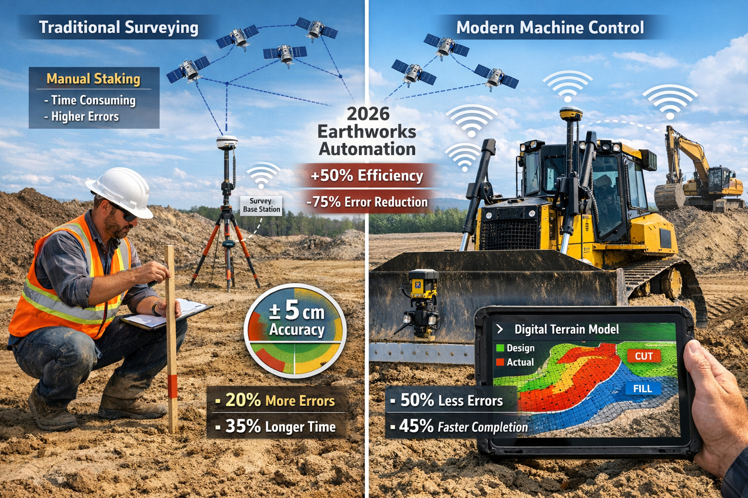
Machine control systems represent the technological marriage between precision surveying and construction equipment automation. These systems use Global Navigation Satellite Systems (GNSS), robotic total stations, and sophisticated onboard computers to guide earthmoving equipment with remarkable precision. Instead of operators relying on visual references, grade stakes, or manual measurements, the machine itself "knows" exactly where it is in three-dimensional space and what the design grade should be at that location.
The fundamental components of a machine control system include:
- GNSS receivers mounted on construction equipment that receive positioning signals from satellite networks
- Onboard computers and displays that show operators real-time cut-fill information and design surfaces
- Hydraulic control systems that automatically adjust blade angles and bucket positions based on design data
- Base station networks established by surveyors to provide correction signals for centimeter-level accuracy
- Digital terrain models created from survey data that define the desired finished grade
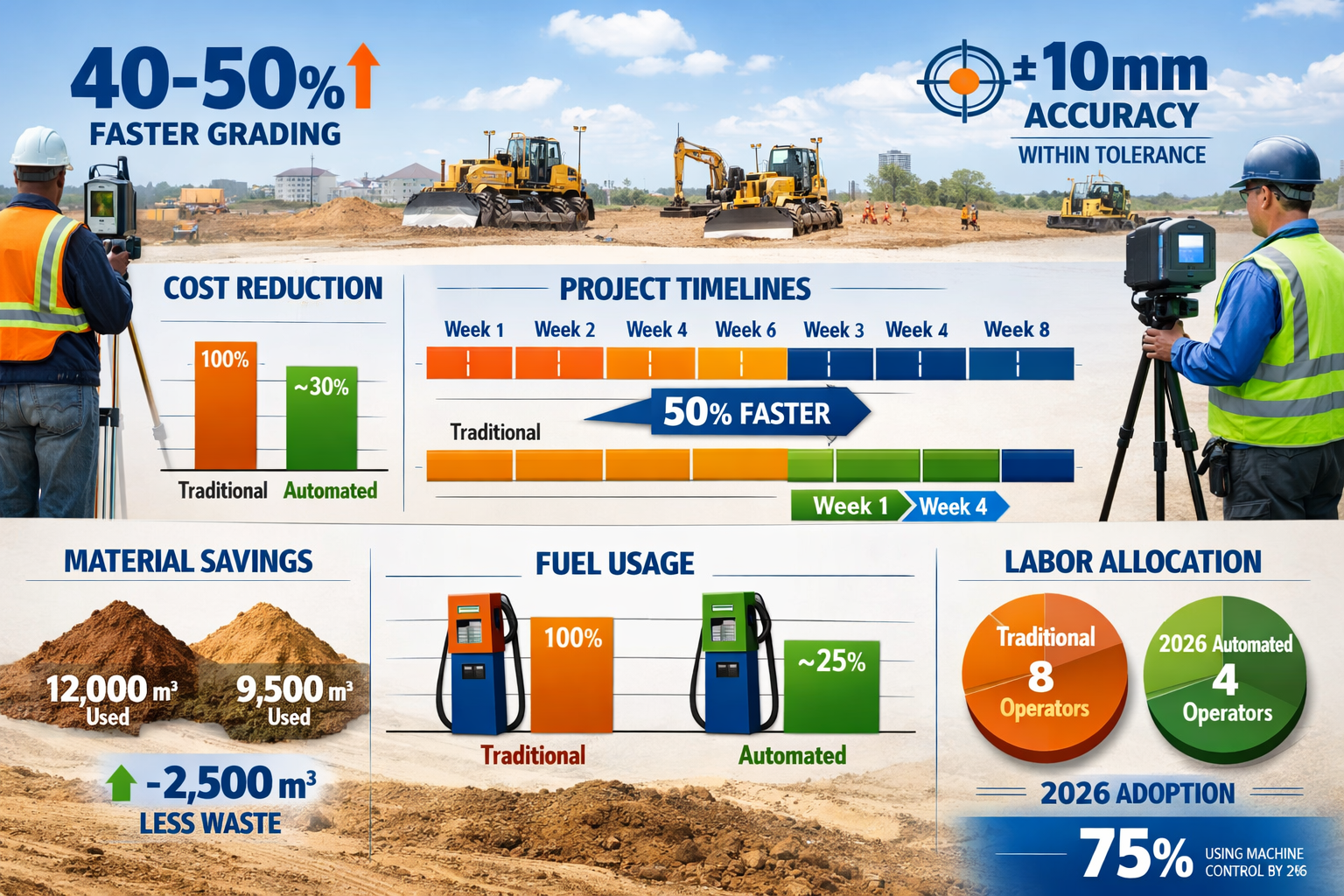
When properly implemented, these systems enable a single operator to achieve grading accuracy within 10-25 millimeters of design specifications—a level of precision that would require extensive manual checking and rework using traditional methods[6].
The Surveyor's Evolving Role in Machine Control Workflows
The introduction of machine control technology has fundamentally redefined the surveyor's role in construction projects. Traditional surveying focused on establishing control networks, creating topographic maps, and providing physical stakeout for contractors. While these functions remain important, surveyors now serve as data infrastructure providers for automated construction operations.
This evolution requires surveyors to:
✅ Establish and maintain high-accuracy control networks that serve as the spatial reference framework for all machine operations
✅ Create comprehensive digital terrain models that accurately represent both existing conditions and design intent
✅ Deliver machine-readable data files in formats compatible with various equipment manufacturers' systems
✅ Provide ongoing quality assurance through as-built verification and progress monitoring
✅ Collaborate in real-time with project teams through cloud-based platforms and common data environments
The shift from periodic site visits to continuous data delivery represents a significant business model change for surveying firms. Rather than completing discrete tasks and moving to the next project, surveyors are increasingly embedded in construction workflows, providing ongoing support throughout the earthworks phase. This creates opportunities for project management integration and recurring revenue streams tied to project duration[1].
Technology Integration: From Survey to Machine
The workflow connecting survey data to machine control systems involves several critical steps, each requiring precision and attention to detail. Understanding this integration is essential for surveyors working on projects where Machine Control Systems in Property Surveying: Automating Earthworks for 2026 Construction Efficiency drive project success.
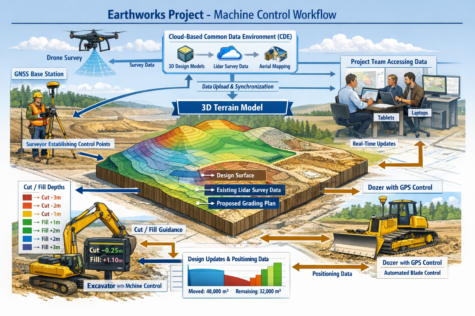
Step 1: Site Control Establishment
Surveyors establish a network of control points using GNSS or conventional surveying methods. These points must be monumented securely and positioned with high accuracy, as they serve as the reference framework for all subsequent work. For machine control applications, control networks typically require positional accuracy within 10-15 millimeters horizontally and vertically[1].
Step 2: Existing Conditions Survey
Before any earthwork begins, surveyors capture the existing site topography. This may involve traditional ground surveys, aerial photogrammetry using drones, terrestrial laser scanning, or mobile mapping systems. The goal is to create a comprehensive digital representation of current conditions that can be compared against design intent to calculate cut-fill volumes and identify potential issues.
Step 3: Digital Terrain Model Creation
Design engineers create a digital terrain model (DTM) representing the desired finished grade. Surveyors often collaborate in this process, ensuring the design model aligns properly with site control and existing conditions data. The DTM typically includes:
- Surface models defining finished grade elevations
- Breaklines representing edges of pavement, curbs, and drainage features
- Cross-sections showing design intent at specific locations
- Alignment data for linear features like roads and utilities
Step 4: Data Format Conversion and Quality Control
Design data must be converted into machine-readable formats specific to each equipment manufacturer (Trimble, Topcon, Leica, etc.). This conversion process requires careful quality control to ensure:
- Coordinate systems match between design and site control
- Elevation datums are consistent throughout
- Surface definitions are mathematically valid
- File sizes are manageable for onboard systems
Step 5: Machine Calibration and Verification
Before automated grading begins, surveyors verify that machine control systems are properly calibrated. This involves checking known control points with the machine-mounted GNSS receivers and confirming that displayed elevations match surveyed values. Regular verification throughout the project ensures continued accuracy.
Step 6: As-Built Documentation and Progress Tracking
As earthwork progresses, surveyors conduct periodic verification surveys to confirm that achieved grades match design specifications. Modern RICS building surveys and verification workflows often incorporate reality capture technology to document conditions efficiently. This creates a feedback loop where survey data informs machine operations, and machine-generated data helps surveyors track progress[1].
The Business Case for Machine Control Systems in Property Surveying: Automating Earthworks for 2026 Construction Efficiency
Quantifying Efficiency Gains and Cost Reductions
The adoption of machine control technology delivers measurable benefits that justify the initial investment for both contractors and property developers. Industry data from 2026 demonstrates compelling efficiency improvements across multiple project types.
Productivity Improvements:
Machine-controlled equipment typically achieves 40-50% faster grading compared to traditional methods[6]. This acceleration stems from several factors:
- Elimination of grade staking reduces surveyor time on site
- Operators work continuously without waiting for stake-out
- Reduced need for manual checking and verification
- Ability to work effectively in low-visibility conditions
Material Cost Savings:
Precise automated grading minimizes over-excavation and reduces material waste. Projects commonly report:
- 10-15% reduction in material quantities through optimized cut-fill balance
- Decreased hauling costs from better material management
- Reduced need for imported fill material
- Lower disposal costs for excess excavation
Labor Efficiency:
Machine control systems enable smaller crews to accomplish more work:
- Single operator can achieve what previously required operator plus grade checker
- Reduced surveyor hours for stakeout and verification
- Fewer personnel needed for quality control activities
- Improved safety through reduced ground personnel near operating equipment
Quality and Rework Reduction:
Automated systems achieve consistent accuracy that reduces costly rework:
- Grading accuracy within 10-25mm of design specifications[6]
- Elimination of staking errors and misinterpretation
- Real-time feedback prevents cumulative errors
- Reduced punch-list items and final grading adjustments
Return on Investment Analysis
For surveying firms considering investment in machine control support capabilities, the financial case depends on project volume and client demand. The global land survey equipment market's growth to $9.22–$10.72 billion in 2026 reflects widespread industry adoption of these technologies[5].
| Investment Category | Typical Cost Range | Payback Period |
|---|---|---|
| GNSS Base Station & Rovers | $30,000-$60,000 | 6-12 months |
| Software Licenses (Design/Modeling) | $5,000-$15,000/year | Immediate (project fees) |
| Training & Certification | $2,000-$5,000/person | 3-6 months |
| Reality Capture Equipment | $15,000-$100,000 | 12-24 months |
| Data Processing Workstations | $3,000-$8,000 | Immediate |
Surveying firms that successfully integrate machine control services typically charge 15-25% premium fees for digital deliverables compared to traditional stakeout services, while reducing field time by 30-40%. This combination of higher revenue and lower costs creates attractive margins for firms serving construction clients[1].
Competitive Advantages for Early Adopters
Surveying practices that embrace machine control integration position themselves advantageously in an increasingly competitive market. The benefits extend beyond individual project profitability:
🎯 Client Retention: Contractors using machine control systems prefer working with surveyors who understand their technology and deliver compatible data efficiently
🎯 Project Diversity: Capability to support machine control opens opportunities on larger, more complex projects where automation is standard
🎯 Professional Differentiation: Expertise in digital workflows distinguishes firms from competitors still focused solely on traditional methods
🎯 Recurring Revenue: Ongoing data support throughout construction phases creates predictable income streams beyond initial survey work
🎯 Industry Leadership: Early adopters establish reputations as technology leaders, attracting both clients and talented staff
The transition to machine control support does require investment in equipment, software, and training. However, firms that view this as strategic infrastructure rather than optional technology are discovering significant competitive advantages in the 2026 market landscape.
Implementation Strategies and Best Practices for Surveyors
Building Machine Control Competency in Your Surveying Practice
Successfully integrating machine control support into a surveying practice requires systematic development of capabilities across technology, personnel, and processes. The following framework provides a roadmap for firms seeking to expand their service offerings in this growing market segment.
Phase 1: Assessment and Planning
Before investing in equipment or training, conduct a thorough assessment of your market opportunity:
- Survey existing clients about their current and planned use of machine control equipment
- Identify competitors offering machine control support services
- Analyze local construction market trends and project types
- Evaluate your firm's current technology infrastructure and capabilities
- Determine realistic revenue projections based on market demand
Phase 2: Technology Investment
Strategic equipment acquisition should align with client needs and project requirements:
Essential Equipment:
- High-accuracy GNSS base station and rover systems
- Robotic total station for verification and areas with GNSS limitations
- Field data collection software compatible with machine control formats
- Office software for digital terrain modeling and data processing
- Cloud-based collaboration platform for project data sharing
Complementary Technology:
- UAV system for aerial survey and progress monitoring
- Terrestrial laser scanner for complex existing conditions
- Mobile mapping system for corridor projects
- Reality capture software for documentation and verification
The investment should be staged based on project demand rather than acquiring all capabilities simultaneously. Many firms begin with GNSS systems and office software, adding specialized equipment as specific project requirements emerge.
Phase 3: Personnel Development
Technology is only effective when operated by skilled professionals. Training investments should include:
✓ Manufacturer-specific training on equipment operation and data processing
✓ Software certification for digital terrain modeling applications
✓ Understanding of machine control system architecture and workflows
✓ Quality control procedures specific to automated construction
✓ Collaboration tools and cloud platform utilization
Consider designating specific team members as machine control specialists who develop deep expertise while training others in fundamental concepts. This creates both specialization and organizational resilience.
Phase 4: Process Development
Standardized workflows ensure consistent quality and efficiency:
- Data delivery standards specifying file formats, coordinate systems, and quality tolerances
- Quality control checklists for model validation and verification
- Communication protocols for coordinating with contractors and project teams
- Documentation procedures for as-built verification and progress tracking
- Pricing structures that reflect the value of digital deliverables
Many successful firms develop internal procedure manuals that document their machine control workflows, creating consistency across projects and facilitating staff training.
Overcoming Common Implementation Challenges
Surveyors entering the machine control support market encounter predictable challenges. Understanding these obstacles and proven solutions accelerates successful implementation.
Challenge 1: Coordinate System Complexity
Machine control systems require absolute consistency in coordinate systems, datums, and units. Mismatches cause equipment to grade to incorrect elevations, creating costly errors.
Solution: Establish rigorous quality control procedures that verify coordinate system parameters at multiple workflow stages. Create standardized project setup templates that minimize manual entry errors. When working with chartered surveyors and valuers on complex projects, document all coordinate system decisions clearly.
Challenge 2: Software Interoperability
Different equipment manufacturers use proprietary file formats, requiring data conversion that can introduce errors.
Solution: Invest in software platforms that support multiple machine control formats. Develop verification procedures that check converted files against source data. Maintain relationships with equipment manufacturers' technical support teams for troubleshooting.
Challenge 3: Client Education
Many clients don't understand the difference between traditional survey deliverables and machine control data requirements.
Solution: Develop clear scope of work descriptions that specify deliverables, accuracy requirements, and responsibilities. Provide client education materials explaining machine control workflows. Include preliminary meetings to align expectations before fieldwork begins.
Challenge 4: Liability and Quality Assurance
When survey data directly controls automated equipment, accuracy becomes critical to safety and project success.
Solution: Implement comprehensive quality control procedures including independent verification of critical data. Clearly define scope boundaries between surveying services and design responsibility. Maintain appropriate professional liability insurance that covers digital deliverables. Document all quality control activities thoroughly.
Challenge 5: Technology Evolution
Machine control systems, software platforms, and industry standards evolve rapidly, requiring ongoing investment.
Solution: Budget for annual technology updates and training. Participate in industry associations and user groups that share best practices. Maintain relationships with equipment manufacturers to stay informed about developments. Consider technology investment as ongoing operational expense rather than one-time capital outlay.
Collaboration and Data Management in Machine Control Projects
The success of Machine Control Systems in Property Surveying: Automating Earthworks for 2026 Construction Efficiency depends heavily on effective collaboration among project stakeholders. The 2026 construction environment increasingly relies on common data environments (CDEs) where spatial information integrates with broader project datasets to enable real-time decision-making[1].
Cloud-Based Collaboration Platforms
Modern machine control workflows utilize cloud platforms that enable:
- Real-time access to current design models and survey data
- Version control preventing use of outdated information
- Progress tracking through automated data collection from equipment
- Issue identification and resolution through visual documentation
- Centralized communication reducing email confusion
Surveyors should evaluate collaboration platforms based on:
📊 Integration capabilities with existing survey software and equipment
📊 Mobile accessibility for field personnel
📊 Security features protecting proprietary project information
📊 Scalability to accommodate projects of varying size
📊 User interface that facilitates adoption by non-technical stakeholders
Data Management Best Practices
Effective data management prevents errors and ensures project efficiency:
- Establish naming conventions for files, surfaces, and features that remain consistent throughout the project
- Implement version control that clearly identifies current versus superseded data
- Create data backup procedures protecting against loss of critical information
- Define access permissions controlling who can view, edit, or approve various data types
- Document data lineage showing the source and processing history of deliverables
Projects that establish clear data management protocols at the outset experience fewer coordination issues and reduced rework compared to those where data management evolves organically.
Integration with Traditional Surveying Services
Machine control support complements rather than replaces traditional surveying services. Successful firms integrate both capabilities seamlessly:
- RICS home surveys and property inspections inform site planning for development projects
- Structural surveys identify existing conditions affecting earthwork design
- Boundary surveys establish legal property limits within which grading must occur
- As-built surveys verify that construction matches approved plans
This integration creates comprehensive service offerings that address client needs throughout the project lifecycle, from initial site assessment through final verification.
Emerging Trends Shaping Machine Control and Surveying in 2026
Artificial Intelligence and Machine Learning Applications
The integration of artificial intelligence (AI) and machine learning into surveying and machine control workflows represents one of the most significant developments in 2026. While these analytical tools remain in early development stages, their potential impact on construction efficiency is substantial[2].
Automated Data Processing
Machine learning algorithms are increasingly automating the analysis of spatial datasets collected from machine control operations:
- Pattern recognition identifying optimal grading sequences based on historical project data
- Anomaly detection flagging potential equipment calibration issues before they affect accuracy
- Predictive maintenance analyzing machine performance data to anticipate component failures
- Quality prediction assessing likely as-built accuracy based on site conditions and equipment parameters
These AI-enhanced capabilities reduce the manual effort required for data processing while improving consistency and identifying issues that human operators might overlook.
Intelligent Design Optimization
Advanced algorithms are beginning to optimize earthwork designs automatically:
- Analyzing multiple cut-fill balance scenarios to minimize material hauling
- Identifying optimal equipment deployment strategies for complex sites
- Suggesting design modifications that improve constructability
- Predicting project duration based on site characteristics and equipment capabilities
While human expertise remains essential for design validation and decision-making, AI tools augment professional judgment with computational analysis that would be impractical manually.
Challenges and Limitations
Despite promising developments, AI integration faces significant challenges:
⚠️ Data quality requirements – Machine learning algorithms require large, high-quality datasets that many firms lack
⚠️ Validation complexity – Verifying AI-generated recommendations requires expertise and time
⚠️ Liability concerns – Determining responsibility when automated systems make errors remains legally unclear
⚠️ Implementation costs – Advanced AI platforms require substantial investment in software and computing infrastructure
The construction industry's movement toward autonomy is characterized as an incremental process rather than rapid transformation, with 2026 continuing to see steady foundational advances in machine intelligence and workflow integration rather than revolutionary breakthroughs[1].
Autonomous and Semi-Autonomous Equipment Evolution
The progression toward fully autonomous construction equipment continues steadily in 2026, though widespread deployment remains several years away. Current developments focus on semi-autonomous systems that augment operator capabilities rather than replacing human control entirely.
Current Autonomous Capabilities
Equipment manufacturers have introduced systems that automate specific tasks:
- Automated dozing where equipment executes repetitive grading patterns with minimal operator input
- Compaction control that automatically adjusts roller patterns to achieve specified density
- Excavation automation for repetitive digging operations like trenching
- Haul truck automation on closed construction sites with controlled access
These capabilities require comprehensive survey data defining work areas, obstacles, and design parameters. Surveyors supporting autonomous equipment must deliver:
🔧 High-definition site models including detailed terrain, structures, and hazards
🔧 Geofenced work zones defining areas where autonomous operation is permitted
🔧 Real-time positioning verification ensuring equipment location accuracy
🔧 Continuous monitoring data documenting autonomous system performance
Surveying Implications of Increasing Autonomy
As equipment autonomy advances, surveyor responsibilities evolve:
The shift from periodic surveys to continuous spatial data infrastructure creates demand for automated monitoring systems. Surveyors are deploying permanent GNSS base stations, automated total stations, and reality capture systems that provide ongoing verification without manual intervention.
Quality assurance becomes increasingly critical as automated systems make decisions based on survey data. The accuracy and completeness of digital terrain models directly impact safety and efficiency, elevating the importance of rigorous quality control procedures.
Documentation requirements expand as autonomous systems generate vast quantities of operational data. Surveyors must develop capabilities for processing, analyzing, and archiving machine-generated spatial information alongside traditional survey data.
Reality Capture and Digital Twin Integration
Reality capture technology serves as a foundational complement to machine control systems in 2026, enabling surveyors to document conditions, visually track construction progress, and collaborate on solutions in real time[1]. The integration of reality capture with machine control workflows creates powerful capabilities for project management and quality assurance.
Photogrammetry and LiDAR Applications
Drones and UAVs equipped with high-resolution cameras and LiDAR sensors are supporting machine control workflows by capturing large-scale topographic data and aerial imagery more efficiently than traditional ground surveys[2]. These systems enable:
- Rapid existing conditions surveys covering large sites in hours rather than days
- Progress monitoring through periodic flights documenting earthwork advancement
- Volume calculations comparing design models against as-built surfaces
- Visual documentation providing context for spatial data and supporting dispute resolution
The data from reality capture systems integrates directly with machine control platforms, creating closed-loop workflows where survey data informs machine operations, and machine-generated data updates digital models.
Mobile 3D Mapping Systems
Mobile mapping systems allow surveyors to create detailed 3D models from diverse environments without bulky equipment, directly supporting machine control systems' need for comprehensive digital terrain representations[2]. Vehicle-mounted and backpack-based systems capture:
- Roadway corridors and linear infrastructure projects
- Complex urban environments with buildings and utilities
- Interior spaces where GNSS positioning is unavailable
- Existing structures requiring precise as-built documentation
The point cloud data from mobile mapping provides rich detail that enhances digital terrain models and supports constructability analysis during design phases.
Digital Twin Development
The concept of digital twins—virtual replicas of physical assets that update continuously throughout their lifecycle—is gaining traction in construction and infrastructure management. Machine control data contributes to digital twin development by:
📍 Documenting as-built conditions with high accuracy during construction
📍 Creating baseline spatial data for asset management systems
📍 Enabling predictive maintenance through comparison of current versus original geometry
📍 Supporting renovation and expansion planning with accurate existing condition models
Surveyors who position themselves as digital twin creators rather than simply data collectors discover opportunities throughout the 75% of an asset's total cost of ownership that accrues during operations and maintenance phases[1]. This requires delivering machine-control-compatible baseline data that integrates with long-term GIS and asset management systems.
Workforce Development and Skills Evolution
The surveying profession enters 2026 amid accelerating digital transformation, driven by pressure to deliver faster and more accurate results while managing workforce shortages and evolving client expectations[1]. The integration of machine control technology both addresses and complicates these workforce challenges.
Changing Skill Requirements
Modern surveyors supporting machine control workflows require competencies that extend beyond traditional surveying fundamentals:
✅ Software proficiency across multiple platforms for data collection, processing, and modeling
✅ Data management understanding file formats, coordinate systems, and quality control procedures
✅ Collaboration skills working effectively in multidisciplinary project teams
✅ Technology troubleshooting diagnosing issues with complex integrated systems
✅ Client communication explaining technical concepts to non-technical stakeholders
Educational programs are adapting curricula to address these evolving requirements, though many practitioners note that formal education lags behind industry practice. Successful firms invest in ongoing training and professional development to maintain staff competencies.
Attracting New Talent
The integration of advanced technology into surveying workflows creates opportunities to attract younger professionals interested in innovation:
- Modern equipment and software appeal to technology-oriented individuals
- Diverse project types provide variety and professional challenge
- Clear career progression from field technician to project manager to specialist roles
- Competitive compensation reflecting specialized technical skills
Firms that effectively market themselves as technology leaders find recruiting advantages in competitive labor markets. Showcasing machine control capabilities and digital workflows differentiates surveying from perceptions of purely field-based manual work.
Balancing Technology and Fundamentals
Despite rapid technological advancement, fundamental surveying principles remain essential. Understanding coordinate systems, error propagation, quality control, and spatial relationships provides the foundation upon which technology capabilities build. The most effective practitioners combine deep technical knowledge with proficiency in modern tools.
Professional organizations and certification programs increasingly emphasize this balance, requiring both traditional competencies and modern technology skills for advanced credentials. Surveyors pursuing RICS certification benefit from demonstrating comprehensive capabilities spanning conventional and digital methodologies.
Practical Applications: Machine Control Across Project Types
Large-Scale Property Development and Subdivision Grading
Large residential and commercial property developments represent ideal applications for Machine Control Systems in Property Surveying: Automating Earthworks for 2026 Construction Efficiency. These projects typically involve:
- Extensive rough grading to establish building pads and roadways
- Precise finish grading for drainage and aesthetics
- Complex utility corridors requiring accurate trenching
- Phased construction over extended timeframes
Project Workflow Example:
A 200-acre mixed-use development requires transformation from agricultural land to finished building pads, roads, and infrastructure. The surveying and machine control workflow proceeds as follows:
- Initial site survey using drone photogrammetry captures existing topography across the entire site in two days
- Control network establishment provides GNSS base station locations and conventional control points for areas with limited satellite visibility
- Design model creation by civil engineers defines finished grades, roads, utilities, and drainage features
- Data conversion and validation by surveyors ensures machine control compatibility and coordinate system consistency
- Rough grading operations using GPS-controlled dozers and scrapers move bulk earthwork efficiently
- Utility installation with machine-guided excavators dig trenches to precise depths and slopes
- Finish grading achieves final elevations within 15mm tolerance using automated blade control
- As-built verification through periodic surveys confirms compliance with design specifications
Throughout the multi-year project, surveyors provide ongoing support, updating models as design changes occur and verifying quality at critical milestones. The continuous engagement model creates recurring revenue and deeper client relationships compared to traditional one-time survey deliverables.
Highway and Infrastructure Corridor Projects
Linear infrastructure projects including highways, railways, and utility corridors benefit significantly from machine control integration. These projects feature:
- Long, narrow work areas requiring efficient equipment deployment
- Precise cross-sectional requirements for drainage and structural support
- Complex transitions and intersections with existing infrastructure
- Stringent quality specifications with limited tolerance for error
Surveying Challenges and Solutions:
Corridor projects present unique challenges that machine control technology addresses effectively:
Challenge: Maintaining accurate positioning over long distances where GNSS base station coverage may be limited
Solution: Establish multiple base stations along the corridor with overlapping coverage zones, or utilize network RTK services that provide corrections via cellular data connections
Challenge: Coordinating with existing infrastructure including utilities, structures, and active roadways
Solution: Comprehensive existing conditions surveys using mobile mapping systems capture detailed 3D data including overhead and underground features, enabling clash detection during design and construction
Challenge: Managing frequent design changes and updates during construction
Solution: Cloud-based collaboration platforms enable real-time distribution of updated models to equipment operators, ensuring all parties work from current information
Projects incorporating machine control typically achieve 30-40% faster completion of earthwork phases compared to traditional methods, with corresponding reductions in traffic disruption and project costs.
Site Preparation for Commercial and Industrial Facilities
Commercial and industrial site development requires precise grading to accommodate large buildings, parking areas, and specialized infrastructure. Machine control systems excel in these applications by:
🏗️ Achieving tight tolerances for building pad elevations that minimize foundation costs
🏗️ Creating complex drainage patterns that prevent water accumulation around structures
🏗️ Coordinating multiple utility systems requiring precise depth and slope control
🏗️ Enabling fast-track construction where earthwork and foundation activities overlap
Case Study Application:
A 500,000 square foot distribution center requires site preparation including:
- Building pad graded to within 10mm tolerance across 15 acres
- Truck maneuvering areas with specific slopes for drainage
- Detention pond with precise volume capacity
- Underground utilities including storm, sanitary, water, and electrical
Traditional stakeout for this project would require surveyors to set thousands of grade stakes, with periodic checking and restaking as work progresses. Using machine control systems, surveyors instead:
- Establish site control network with six GNSS base points
- Create comprehensive digital terrain model including all design features
- Provide machine control files to multiple equipment operators
- Conduct periodic verification surveys at key milestones
- Perform final as-built survey documenting achieved grades
The machine control approach reduces surveyor field time by approximately 60% while improving grading accuracy and enabling faster project completion. The efficiency gains translate to lower costs for the property owner and improved profitability for both surveyor and contractor.
Specialized Applications: Mining, Landfills, and Remediation
Beyond typical construction projects, machine control technology supports specialized applications including:
Mining Operations:
- Precise excavation following mineral deposits
- Highwall and pit floor grade control for safety
- Haul road maintenance and optimization
- Volume calculations for production tracking
Landfill Management:
- Cell construction following engineered designs
- Liner and cap placement with strict tolerance requirements
- Volume tracking for capacity management
- Compliance documentation for regulatory requirements
Environmental Remediation:
- Contaminated soil excavation to precise depths
- Cap construction preventing contaminant migration
- Restoration grading matching natural topography
- Documentation supporting regulatory closure
These applications often require specialized expertise beyond typical construction surveying. Firms developing niche capabilities in these markets discover opportunities for premium pricing and long-term client relationships. The integration with commercial building surveys and specialized assessment services creates comprehensive offerings for industrial clients.
Future Outlook: The Next Phase of Machine Control Evolution
Predictive Analytics and Performance Optimization
The next evolution in Machine Control Systems in Property Surveying: Automating Earthworks for 2026 Construction Efficiency involves leveraging the vast quantities of operational data these systems generate. Every machine-controlled equipment operation creates spatial data documenting:
- Actual versus design elevations at millions of points
- Equipment productivity rates across varying soil conditions
- Operator performance metrics and efficiency patterns
- Environmental factors affecting construction progress
Emerging Analytical Capabilities:
Advanced analytics platforms are beginning to extract actionable insights from this data:
📈 Productivity benchmarking comparing actual performance against historical norms and identifying improvement opportunities
📈 Soil condition mapping correlating equipment performance with subsurface characteristics to inform future projects
📈 Equipment optimization recommending ideal machine types and configurations for specific site conditions
📈 Schedule prediction forecasting completion dates based on current progress and historical performance data
These capabilities require integration between machine control systems, project management platforms, and analytical tools—an ecosystem that is emerging but not yet mature in 2026. Surveyors who develop expertise in data analytics position themselves as strategic advisors rather than simply data providers.
Regulatory and Standards Development
As machine control technology becomes standard practice, regulatory frameworks and industry standards are evolving to address quality assurance, liability, and professional responsibility. Key developments include:
Accuracy Standards:
Professional organizations are developing specifications for machine control survey deliverables, defining acceptable tolerances for control networks, digital terrain models, and as-built verification. These standards provide clarity for contracts and help establish professional liability boundaries.
Certification Programs:
Equipment manufacturers and professional associations offer certification programs validating competency in machine control workflows. These credentials help clients identify qualified service providers and support professional development.
Legal Framework Evolution:
Courts and insurance providers are establishing precedents regarding liability when automated systems operate based on survey data. Clear contractual language defining responsibilities and limitations becomes increasingly important.
Data Retention Requirements:
Regulatory agencies are beginning to require retention of machine control data for infrastructure projects, creating long-term archival responsibilities for surveyors and contractors. Integration with asset management systems addresses these requirements while creating value for owners.
Surveyors should actively participate in standards development through professional organizations, helping shape frameworks that reflect practical realities while protecting professional interests.
Integration with Broader Construction Technology Ecosystem
Machine control systems represent one component of an expanding construction technology ecosystem. The 2026 landscape includes:
- Building Information Modeling (BIM) platforms coordinating design across disciplines
- Project management software tracking schedules, costs, and resources
- Quality management systems documenting inspections and compliance
- Safety monitoring technology protecting workers and the public
- Sustainability tracking measuring environmental impacts and carbon footprint
The most powerful applications emerge when these systems integrate seamlessly, sharing data and enabling holistic project insights. Surveyors who understand this broader ecosystem and position their services as connective tissue between various platforms create unique value.
Interoperability Challenges:
Despite progress, significant interoperability challenges remain:
- Proprietary data formats limiting information exchange
- Inconsistent coordinate systems and reference frameworks
- Varying levels of data precision and quality across systems
- Complex licensing and access control requirements
Industry initiatives promoting open standards and common data environments are addressing these challenges, though full interoperability remains aspirational rather than realized in 2026.
Sustainability and Environmental Considerations
Machine control technology contributes to construction sustainability goals through:
🌱 Material waste reduction from precise grading minimizing over-excavation
🌱 Fuel efficiency through optimized equipment operation and reduced rework
🌱 Carbon footprint tracking enabled by detailed operational data
🌱 Ecosystem protection through precise work limits preventing unnecessary disturbance
As environmental regulations tighten and clients prioritize sustainability, these benefits become increasingly important. Surveyors who quantify and document environmental benefits of machine control workflows help clients achieve sustainability goals while differentiating their services.
Green Infrastructure Applications:
Machine control systems support specialized sustainable construction techniques:
- Permeable pavement installation requiring precise grade control for drainage
- Green roof substrate placement with specific depth requirements
- Bioswale and rain garden construction following complex grading designs
- Wetland restoration matching natural topography and hydrology
These applications often require collaboration with environmental specialists and landscape architects, creating opportunities for surveyors to expand their professional networks and service offerings. The integration with RICS specific defect surveys and environmental assessment capabilities provides comprehensive solutions for environmentally sensitive projects.
Conclusion: Positioning Your Practice for Success in the Machine Control Era
The integration of Machine Control Systems in Property Surveying: Automating Earthworks for 2026 Construction Efficiency represents a fundamental transformation in how construction projects are executed. Surveyors who embrace this change and develop comprehensive machine control support capabilities position themselves for success in an evolving market characterized by increasing automation, digital collaboration, and performance-driven client expectations.
The transition from traditional surveying to machine control support requires strategic investment in technology, personnel development, and process refinement. However, the benefits extend far beyond individual project profitability. Firms that successfully make this transition discover:
✨ Competitive differentiation in crowded markets where traditional services become commoditized
✨ Client relationship depth through ongoing engagement rather than transactional project delivery
✨ Revenue diversification with recurring income streams complementing project-based fees
✨ Professional satisfaction from working with advanced technology on complex, impactful projects
✨ Organizational resilience through capabilities that address current and emerging client needs
The surveying profession's evolution toward digital infrastructure provision aligns with broader construction industry trends toward automation, data-driven decision-making, and integrated project delivery. Surveyors who view themselves as essential participants in this transformation—rather than passive observers affected by it—shape their own futures and contribute to industry advancement.
Actionable Next Steps for Surveying Professionals
For surveyors seeking to develop or expand machine control capabilities, consider these concrete actions:
Immediate Actions (Next 30 Days):
- Assess current client base for machine control usage and future adoption plans
- Research equipment options from major manufacturers (Trimble, Topcon, Leica) and identify systems matching client needs
- Evaluate software platforms for digital terrain modeling and data processing
- Connect with local contractors using machine control to understand their surveying requirements and pain points
- Review professional liability insurance to ensure coverage for digital deliverables
Short-Term Development (3-6 Months):
- Acquire essential equipment starting with GNSS systems and modeling software
- Complete manufacturer training on selected equipment and software platforms
- Develop standard workflows documenting procedures for machine control projects
- Create sample deliverables and pricing structures for machine control services
- Market new capabilities to existing clients and target prospects in development and infrastructure sectors
Long-Term Strategic Initiatives (6-24 Months):
- Build specialized expertise in specific project types or technologies where market demand is strong
- Develop strategic partnerships with contractors, engineers, and technology providers
- Invest in complementary technologies such as reality capture and mobile mapping
- Participate in industry organizations to stay informed about developments and contribute to standards
- Cultivate next-generation talent through training programs and technology-forward recruiting
The path to machine control competency is neither instantaneous nor without challenges. However, the surveying firms that commit to this journey discover sustainable competitive advantages and position themselves as essential partners in modern construction delivery.
The construction industry's digital transformation continues accelerating in 2026 and beyond. Machine control systems represent a mature, proven technology delivering measurable benefits across diverse project types. For surveyors, the question is not whether to develop these capabilities, but how quickly and strategically to do so. Those who act decisively while others hesitate will establish market positions that compound over time, creating lasting professional and business success.
Whether you're a sole practitioner exploring new service offerings or a large firm refining existing capabilities, the integration of machine control support into your practice represents an investment in relevance, competitiveness, and professional growth. The future of surveying is digital, collaborative, and increasingly automated—and that future is already here.
For surveyors ready to embrace this evolution, the opportunities are substantial and the timing is ideal. Begin your journey today, and position your practice at the forefront of the profession's most significant transformation in generations.
References
[1] Doubling Down On Digital – https://amerisurv.com/2026/02/01/doubling-down-on-digital/
[2] The Future Of Land Surveying Technology And Upcoming Trends In 2026 – https://metricop.com/blogs/land-surveying/the-future-of-land-surveying-technology-and-upcoming-trends-in-2026
[3] Doubling Down On Digital Top 6 Surveying Trends Shaping 2026 From Trimble Experts – https://nottinghillsurveyors.com/blog/doubling-down-on-digital-top-6-surveying-trends-shaping-2026-from-trimble-experts
[4] Carlson Construction – https://carlsonps.com/products/carlson-construction
[5] Navigating The 2026 Land Survey Equipment Boom Total Stations Gps And Laser Scanners Reviewed – https://nottinghillsurveyors.com/blog/navigating-the-2026-land-survey-equipment-boom-total-stations-gps-and-laser-scanners-reviewed
[6] Machine Control Model – https://www.quantumlanddesign.com/machine-control-model