}
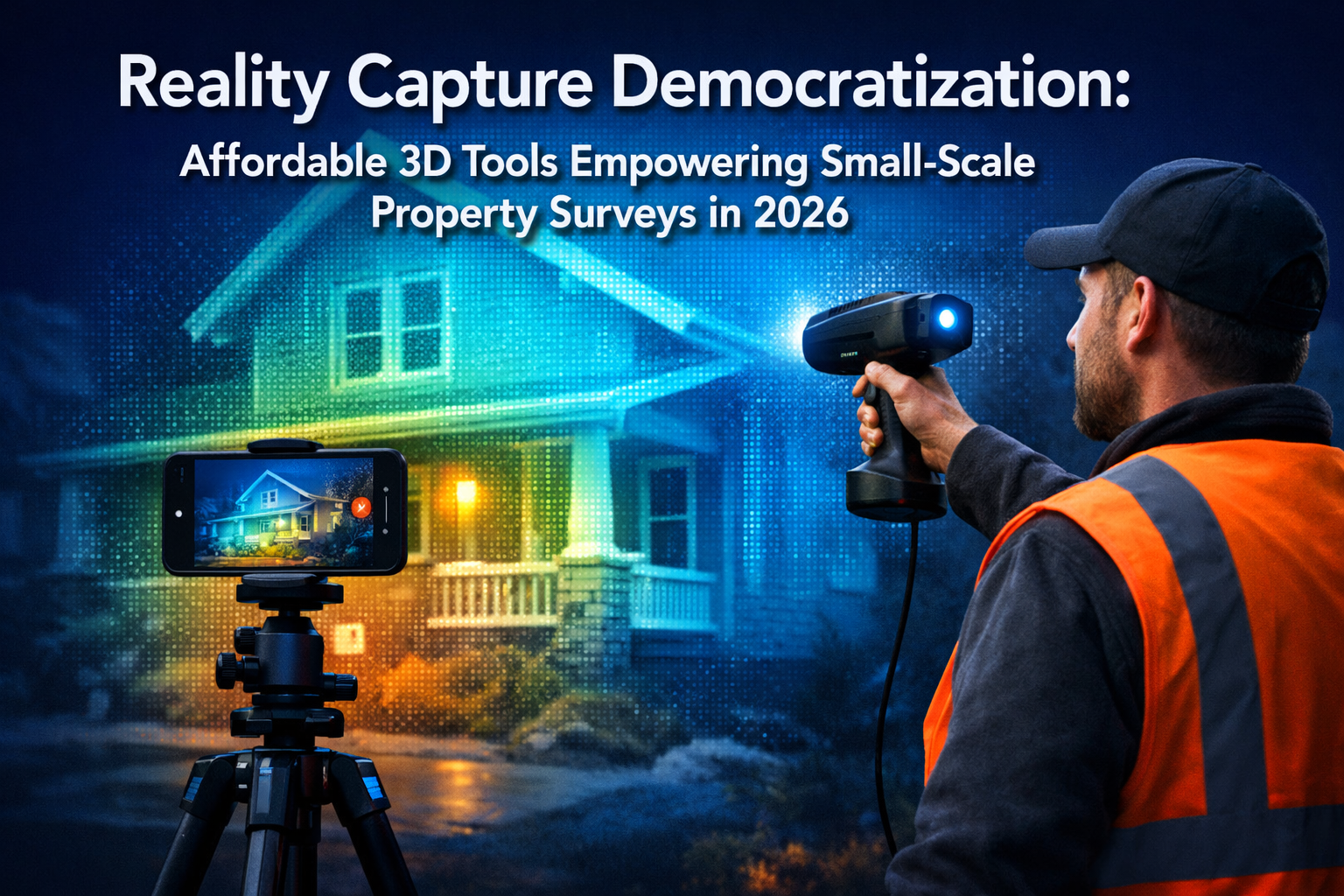
The surveying profession stands at a pivotal moment in 2026. What once required substantial capital investment and specialized expertise—high-precision 3D reality capture—has become accessible to independent surveyors and small firms serving residential and small commercial clients. This transformation represents more than technological advancement; it signals a fundamental restructuring of competitive dynamics within the property surveying industry. Reality Capture Democratization: Affordable 3D Tools Empowering Small-Scale Property Surveys in 2026 is reshaping how professionals deliver value, enabling precision previously reserved for large-scale infrastructure projects to become standard practice for everyday property assessments.
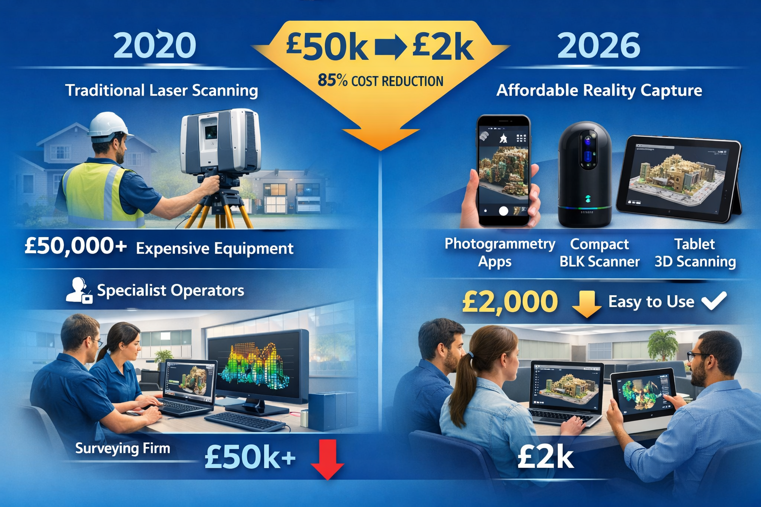
The barriers that once separated boutique surveying practices from enterprise-level capabilities are dissolving rapidly. Mobile phone-based capture systems, cloud collaboration platforms, and user-friendly processing software have reduced entry costs by over 85% compared to traditional laser scanning systems[1]. Independent surveyors conducting homebuyer surveys or dilapidation surveys can now deliver 3D visualizations and millimeter-accurate measurements without investing tens of thousands of pounds in specialized equipment.
Key Takeaways
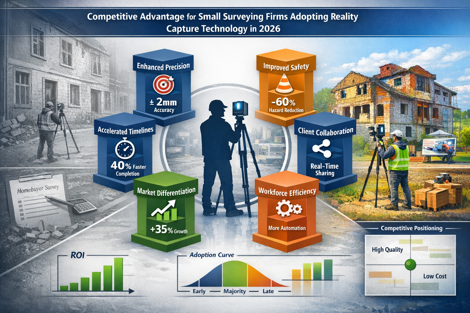
✅ Accessibility Revolution: Reality capture technology has evolved from specialized equipment costing £50,000+ to smartphone-based solutions under £2,000, enabling small surveying firms to compete with enterprise-level precision[1].
✅ Enhanced Service Delivery: Surveyors using affordable 3D tools report 40% faster project completion, improved safety outcomes, and enhanced client collaboration through real-time visual data sharing[1].
✅ Strategic Integration Over Technology: Industry maturity in 2026 emphasizes delivering sustained value through data integration rather than focusing solely on capture capabilities[4].
✅ Workforce Transformation: Automated reality capture systems handle routine measurement tasks, freeing professionals to focus on complex analysis, client relationships, and strategic problem-solving[1].
✅ Market Differentiation: Small firms integrating reality capture into core services position themselves as collaborative partners rather than measurement vendors, commanding premium fees and longer-term client relationships[1].
Understanding Reality Capture Democratization in the Surveying Context
Reality capture refers to the process of digitally documenting physical spaces through technologies including laser scanning, photogrammetry, and LiDAR (Light Detection and Ranging). The output—typically point cloud data representing millions of precise spatial measurements—creates a digital twin of the surveyed environment.
The Traditional Barrier to Entry
Historically, reality capture remained the domain of large surveying firms and specialized consultancies. The technology stack required significant investment:
- Terrestrial laser scanners: £40,000-£120,000 per unit
- Processing software licenses: £5,000-£15,000 annually
- Specialized training: Weeks of certification courses
- Dedicated personnel: Full-time operators with technical expertise
- High-performance computing: Workstations capable of processing massive datasets
For a small practice conducting structural surveys or subsidence assessments, these costs represented an insurmountable barrier. Traditional measurement methods—tape measures, total stations, and manual documentation—remained the practical choice despite their limitations.
The 2026 Transformation
Reality Capture Democratization: Affordable 3D Tools Empowering Small-Scale Property Surveys in 2026 has fundamentally altered this equation. According to Arnaud Lezennec, senior applications engineer at Trimble, "New user-friendly tools will enable even more comprehensive data collection and in-field treatment for faster and improved decision making, as well as capture from mobile phones and robust mobile mapping systems"[1].
This democratization manifests across multiple dimensions:
| Traditional Reality Capture | Democratized Reality Capture (2026) |
|---|---|
| £50,000+ initial investment | £1,500-£5,000 entry point |
| Weeks of specialized training | Hours of guided tutorials |
| Dedicated technical operators | General surveying professionals |
| Desktop processing only | Cloud-based processing available |
| Days for data processing | Real-time or same-day results |
| Proprietary data formats | Open, interoperable standards |
Mobile Phone Capture: The Game-Changer
The integration of LiDAR sensors into consumer smartphones (particularly iPhone Pro models since 2020) has accelerated dramatically. By 2026, these devices deliver accuracy sufficient for many small-scale property surveys:
- Measurement precision: ±10-20mm for distances under 5 meters
- Capture speed: Complete room scan in 2-3 minutes
- Processing: On-device or instant cloud upload
- Cost: No additional hardware beyond existing smartphone
- Accessibility: Intuitive interfaces requiring minimal training
For surveyors conducting property inspections, this represents a paradigm shift. A single professional can now capture comprehensive spatial data during a standard site visit, eliminating return trips and reducing project timelines by 30-40%[1].
Affordable 3D Tools Transforming Small-Scale Property Surveys
The hardware and software ecosystem supporting Reality Capture Democratization: Affordable 3D Tools Empowering Small-Scale Property Surveys in 2026 has expanded dramatically. Independent surveyors now choose from tiered solutions matching specific service requirements and budget constraints.
Entry-Level Solutions (£0-£2,000)
Smartphone-Based Photogrammetry
Applications like Polycam, 3D Scanner App, and RoomScan LiDAR transform standard smartphones into capable 3D capture devices. These solutions excel for:
- Interior room documentation
- Facade condition assessments
- Roof surveys (exterior only)
- Quick volumetric measurements
- Client visualization and communication
Advantages: Zero additional hardware cost, immediate deployment, client-friendly visualization, cloud storage integration.
Limitations: Lower accuracy than dedicated scanners (±20mm), lighting-dependent, limited range (5-10 meters), processing requires good connectivity.
Practical Application: A surveyor conducting a homebuyer survey can capture every room in 3D within 30 minutes, providing clients with immersive walkthroughs and precise measurements for renovation planning—all using equipment already in their pocket.
Mid-Range Professional Tools (£2,000-£10,000)
Handheld SLAM Scanners
Leica Geosystems' BLK series represents purpose-built reality capture sensors specifically designed to "democratize reality capture worldwide"[5]. These devices incorporate:
- SLAM technology: Simultaneous Localization and Mapping for real-time positioning
- Sensor fusion: Combining multiple data streams for enhanced accuracy
- Autonomous scanning: Automated capture reducing operator skill requirements
- Integrated imaging: RGB cameras for texture mapping
- Portable form factor: Handheld or pole-mounted operation
Accuracy: ±10mm at 10 meters, suitable for most property surveying applications.
Capture speed: 2,000-4,000 square meters per hour.
Use cases: Commercial property surveying, dilapidation assessments, as-built documentation, structural engineering support.
"The BLK series has transformed our practice. We're delivering enterprise-quality deliverables to small commercial clients who previously couldn't justify the cost of 3D documentation. The competitive advantage is substantial." — Independent Chartered Surveyor, Manchester
Software Democratization
Processing and visualization software has undergone parallel democratization. Cloud-based platforms eliminate expensive workstation requirements:
Trimble Reality Capture Platform
This service enables users to "collaborate, share, store and manage large amounts of reality capture data in the cloud, seamlessly linking data and sharing with non-technical stakeholders through Trimble Connect's common data environment"[2].
Key features:
- Browser-based access (no specialized software installation)
- Automated processing pipelines
- Collaborative markup and annotation
- Integration with BIM and CAD platforms
- Subscription pricing (£50-£200/month vs. £10,000+ perpetual licenses)
Client-Facing Benefits: Property owners and developers can access survey data through simple web links, viewing 3D models on tablets or computers without technical expertise. This transparency builds trust and accelerates decision-making.
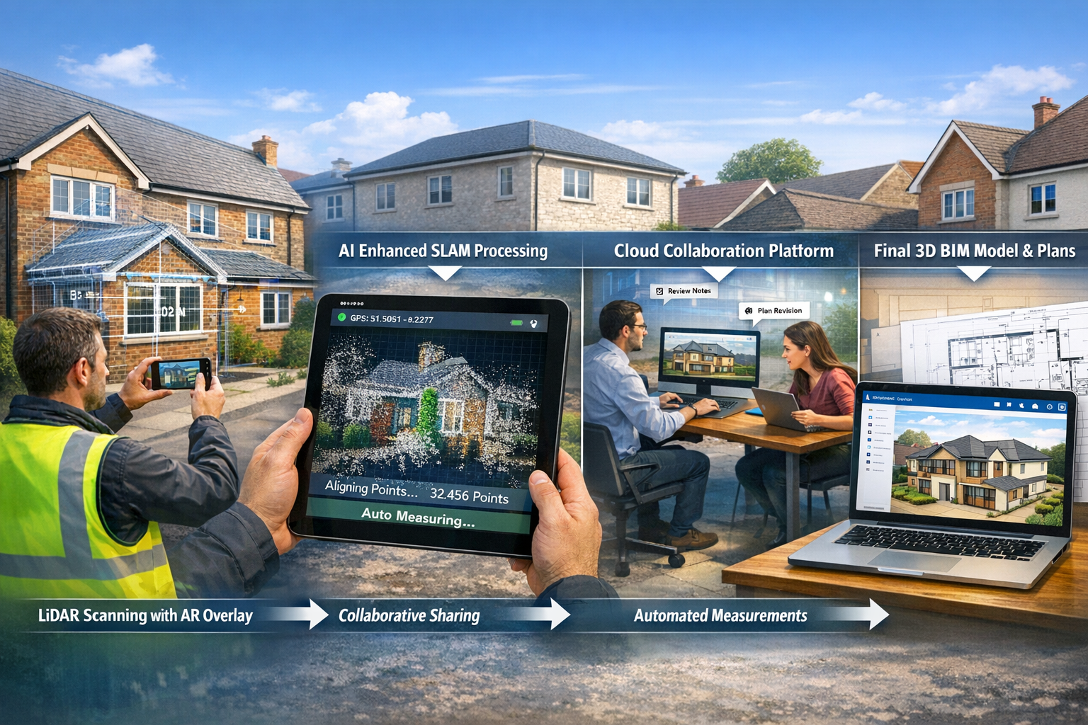
Workflow Integration
The true power of Reality Capture Democratization: Affordable 3D Tools Empowering Small-Scale Property Surveys in 2026 emerges through workflow integration. Modern surveyors combine multiple tools strategically:
- Initial site visit: Smartphone capture for quick documentation and client communication
- Detailed assessment: Handheld SLAM scanner for precise measurements in critical areas
- Cloud processing: Automated alignment and registration
- Collaborative review: Client access through common data environment
- Deliverable generation: Automated floor plans, elevations, and measurement reports
This layered approach optimizes cost-effectiveness while maintaining professional standards appropriate for RICS-certified work.
Strategic Implementation for Small Surveying Practices
Technology acquisition represents only the first step. Successful implementation of Reality Capture Democratization: Affordable 3D Tools Empowering Small-Scale Property Surveys in 2026 requires strategic planning addressing service design, client communication, and competitive positioning.
Service Portfolio Expansion
Reality capture enables small practices to offer services previously impossible with traditional methods:
Enhanced Dilapidation Surveys
Dilapidation surveys benefit enormously from 3D documentation. Rather than photographic evidence and written descriptions, surveyors deliver:
- Baseline 3D models: Precise documentation of property condition at lease commencement
- Temporal comparison: Overlay scans from different dates to identify changes
- Dispute resolution: Objective measurements replacing subjective assessments
- Remote review: Landlords and tenants examine conditions without site visits
Premium positioning: Firms offering 3D-enhanced dilapidation services command 25-40% fee premiums while reducing dispute resolution costs for clients.
Integrated Structural Assessments
Combining reality capture with structural engineering expertise creates powerful service offerings:
- Precise deflection measurements for subsidence investigations
- Detailed crack mapping with millimeter-level tracking
- Load-bearing element documentation for beam calculations
- Historical comparison for progressive monitoring
Virtual Property Inspections
The 2026 market increasingly values remote capabilities. Surveyors can offer:
- Preliminary assessments: Clients review 3D captures before commissioning full surveys
- International clients: Overseas investors examine properties without travel
- Portfolio management: Property managers monitor multiple assets efficiently
- Insurance documentation: Comprehensive condition records for claims support
Client Communication Transformation
Reality capture fundamentally changes how surveyors communicate findings. Traditional text-heavy reports with 2D photographs give way to interactive experiences:
Visual-First Reporting
Design conversations now take place "directly within 3D models rather than traditional 2D plans, enabling quicker iterations and faster workflows"[1]. This shift benefits both surveyor and client:
- Reduced ambiguity: Clients understand spatial relationships intuitively
- Faster decisions: Visual clarity accelerates approval processes
- Enhanced credibility: Professional 3D deliverables signal expertise
- Competitive differentiation: Stand out from traditional report formats
Collaborative Platforms
Common data environments provide "consistent access to documentation, context, and visualization across construction and operations phases"[1]. For small-scale property surveys, this means:
- Clients access survey data 24/7 through secure web portals
- Contractors reference precise measurements during renovation planning
- Property certification processes incorporate verified spatial data
- Long-term asset management builds on comprehensive baseline documentation
Competitive Positioning Strategy
At Geo Week 2026, the Reality Capture Network emphasized that the field is maturing beyond "what a tool can capture" toward strategic consideration of "how data can deliver sustained value over time"[4]. This insight guides positioning strategy for small practices.
From Vendor to Partner
Surveying firms that integrate reality capture into core service offerings "position themselves as essential partners rather than measurement service vendors"[1]. This transition involves:
📊 Value-based pricing: Charging for outcomes (risk reduction, decision acceleration) rather than time spent
🤝 Ongoing relationships: Providing periodic rescans for condition monitoring rather than one-time assessments
🔄 Data stewardship: Managing clients' spatial data assets over property lifecycles
💡 Strategic advisory: Recommending interventions based on temporal data analysis
Market Differentiation Messaging
Effective positioning communicates specific advantages:
❌ Avoid: "We use the latest 3D scanning technology"
✅ Instead: "Our 3D documentation eliminates measurement disputes and accelerates your renovation planning by 40%"
❌ Avoid: "High-tech survey solutions"
✅ Instead: "Access your property data anywhere, anytime—share precise measurements with contractors instantly through our client portal"
Workforce Development
Automated systems handle routine tasks, "freeing professionals to focus on complex problem-solving and client relationships"[1]. This addresses surveying industry workforce shortages while improving work quality.
Skill Evolution Requirements:
- Technical proficiency: 8-12 hours training on specific hardware/software platforms
- Data interpretation: Understanding point cloud quality, accuracy limitations, appropriate applications
- Client education: Explaining 3D deliverables to non-technical stakeholders
- Integration knowledge: Connecting reality capture data with BIM, CAD, and GIS systems
Junior surveyor development: Reality capture provides engaging entry points for early-career professionals, offering immediate value contribution while building foundational surveying knowledge.
Practical Applications Across Property Survey Types
Reality Capture Democratization: Affordable 3D Tools Empowering Small-Scale Property Surveys in 2026 delivers tangible benefits across the spectrum of property surveying services.
Residential Property Surveys
Homebuyer Surveys with 3D Enhancement
Traditional homebuyer surveys provide condition assessments and risk identification. 3D capture adds significant value:
- Space planning: Buyers visualize furniture placement and renovation possibilities
- Measurement verification: Precise room dimensions for mortgage valuations
- Defect documentation: 3D-positioned photographs showing exact locations of concerns
- Future reference: Baseline documentation for insurance and maintenance planning
Implementation: A surveyor conducts the standard inspection while simultaneously capturing smartphone-based 3D scans (adding 15-20 minutes). Processing occurs automatically via cloud upload. The client receives both the traditional report and an interactive 3D model within 48 hours.
Fee impact: £150-£250 premium on standard homebuyer survey fees (£400-£600), representing 30-40% increase for minimal additional time investment.
Commercial Property Applications
Lease Dilapidation Documentation
Schedule of dilapidations work requires meticulous documentation of property condition. Reality capture provides:
- Objective evidence: Millimeter-accurate measurements replacing subjective assessments
- Comprehensive coverage: Complete spatial documentation reducing "missed items" risk
- Temporal analysis: Overlay scans from lease commencement and termination
- Dispute reduction: Visual evidence reducing costly arbitration
Case scenario: A small surveying practice documents a 2,000 sq ft retail unit at lease commencement using a handheld SLAM scanner (2 hours on-site). Five years later, they rescan the property (1.5 hours). Cloud-based comparison tools automatically identify changes, generating a preliminary dilapidations schedule in hours rather than days. The objective evidence facilitates settlement without formal dispute procedures, saving the client £15,000+ in legal costs.
Specialized Survey Applications
Subsidence Investigation
Subsidence surveys require precise measurement of structural movement. Traditional methods involve manual leveling and crack width gauges. 3D reality capture enables:
- Baseline documentation: Complete structural geometry capture before monitoring begins
- Periodic rescanning: Monthly or quarterly captures tracking movement patterns
- Automated comparison: Software identifies changes below human visual detection thresholds
- Predictive analysis: Movement trends inform intervention timing and methodology
Accuracy advantage: Handheld SLAM scanners detect movements of 5-10mm across entire structures, whereas manual measurements capture only discrete points.
Roof Surveys and Structural Assessments
Roof surveys benefit from reality capture's safety advantages:
- Reduced access requirements: Drone-based photogrammetry captures roof conditions without physical access
- Comprehensive coverage: Complete roof geometry including difficult-to-access areas
- Measurement accuracy: Precise slope calculations for solar panel installations
- Client visualization: 3D models showing proposed modifications in context
Safety impact: Eliminating unnecessary roof access reduces fall risk—the leading cause of construction-related fatalities.
Asset Management and GIS Integration
3D GIS and modeling technology innovations create "opportunities for surveyors to provide ongoing value beyond traditional project boundaries, addressing municipalities' and asset owners' need to manage aging infrastructure with constrained resources"[1].
Long-term client relationships: Rather than one-time survey commissions, surveyors become ongoing spatial data managers:
- Periodic rescanning: Annual or biennial captures tracking property condition evolution
- Maintenance planning: Spatial data informing preventive maintenance scheduling
- Capital planning: Condition trends supporting renovation budget forecasting
- Portfolio optimization: Multi-property owners comparing condition across assets
This shift from transactional to relationship-based business models provides revenue stability and deepens client partnerships.
Overcoming Implementation Challenges
While Reality Capture Democratization: Affordable 3D Tools Empowering Small-Scale Property Surveys in 2026 offers substantial opportunities, small practices face practical challenges requiring strategic responses.
Technical Considerations
Data Management
Point cloud files consume substantial storage (1-5GB per typical property scan). Small practices must address:
- Cloud storage costs: Budget £30-£100/month for adequate capacity
- Backup procedures: Implement automated redundancy preventing data loss
- Retention policies: Define how long to maintain client data (recommendation: 7-10 years)
- Access security: Ensure GDPR compliance for client data protection
Solution: Cloud-based platforms like Trimble Reality Capture include storage in subscription pricing, eliminating separate infrastructure costs[2].
Quality Assurance
Reality capture introduces new quality control requirements:
- Coverage verification: Ensuring no gaps in scan coverage
- Accuracy validation: Confirming measurements meet professional standards
- Registration quality: Verifying proper alignment of multiple scans
- Deliverable review: Checking 3D models before client delivery
Best practice: Develop standardized checklists for each survey type, incorporating reality capture-specific quality checks alongside traditional surveying verification procedures.
Business Model Adaptation
Pricing Strategy
Determining appropriate fees for 3D-enhanced services requires balancing:
- Cost recovery: Amortizing equipment investment over project volume
- Value pricing: Charging for client benefits rather than time spent
- Market positioning: Maintaining competitiveness while signaling premium quality
- Service bundling: Deciding whether 3D is standard or optional enhancement
Recommended approach: Offer tiered service levels—standard surveys at traditional pricing, premium 3D-enhanced versions at 25-40% uplift, and comprehensive digital twin packages for high-value properties at 60-100% premium.
Client Education
Many property owners and small developers lack familiarity with reality capture benefits. Effective education strategies include:
- Sample deliverables: Showcase 3D models from previous projects (with permission)
- Comparative demonstrations: Show traditional vs. 3D-enhanced survey outputs side-by-side
- ROI quantification: Demonstrate time savings and decision acceleration
- Pilot programs: Offer first-time clients introductory pricing to build case studies
Professional Standards Compliance
RICS and other professional bodies are developing guidance for reality capture integration. Small practices should:
✅ Maintain traditional competencies: 3D tools complement rather than replace fundamental surveying knowledge
✅ Document methodologies: Record equipment specifications, accuracy limitations, and processing procedures
✅ Transparent communication: Clearly explain deliverable limitations to clients
✅ Continuing professional development: Participate in reality capture training programs
✅ Professional indemnity insurance: Verify coverage extends to 3D deliverables and digital services
Future Trajectory and Strategic Preparation
The democratization trend shows no signs of slowing. Understanding emerging developments enables small practices to position strategically for continued evolution.
AI and Machine Learning Integration
Reality capture is being "enhanced by AI, machine learning, and cloud-based platforms, enabling spatial data to serve as a common visual language across project stakeholders"[1]. Practical applications emerging in 2026 include:
Automated Feature Extraction
Machine learning algorithms automatically identify and classify building elements:
- Defect detection: AI flags cracks, dampness, and structural anomalies
- Material identification: Automated recognition of construction materials
- Measurement automation: Instant generation of floor plans and elevations
- Change detection: Highlighting differences between temporal scans
Impact for small practices: Tasks requiring hours of manual work (measuring rooms, creating floor plans, identifying defects) become automated, dramatically improving productivity and consistency.
Augmented Reality Integration
AR visualization of survey data directly on-site transforms field workflows:
- Real-time comparison: Overlay previous scans on current conditions via tablet or smartphone
- Design visualization: Show proposed modifications in situ during client consultations
- Collaborative markup: Multiple stakeholders annotate 3D models simultaneously
- Guided inspection: AR overlays highlight areas requiring detailed examination
Sensor Fusion and Multi-Modal Capture
Integration of diverse data sources creates comprehensive property intelligence:
- Thermal imaging: Combining 3D geometry with thermal data for damp surveys
- Acoustic analysis: Integrating sound transmission data for acoustic assessments
- Environmental monitoring: Embedding air quality and environmental sensors
- Structural health monitoring: Continuous vibration and movement sensors
Strategic opportunity: Surveyors offering integrated multi-sensor assessments differentiate from both traditional competitors and pure-technology providers.
Standardization and Interoperability
Industry maturity drives standardization initiatives:
- Open data formats: Universal standards enabling cross-platform compatibility
- Quality benchmarks: Defined accuracy standards for different survey types
- Deliverable specifications: Standardized outputs facilitating client comparison
- Integration protocols: Seamless connection with BIM, GIS, and asset management systems
Preparation strategy: Adopt open standards early, participate in industry working groups, and build workflows around interoperable rather than proprietary formats.
Conclusion: Seizing the Democratization Opportunity
Reality Capture Democratization: Affordable 3D Tools Empowering Small-Scale Property Surveys in 2026 represents a generational opportunity for independent surveyors and small practices. The technology barriers that once protected large firms' competitive advantages have dissolved, creating a level playing field where service quality, client relationships, and strategic positioning determine success.
The evidence is compelling: reality capture technology has demonstrated "tangible benefits through enhanced precision, improved safety outcomes, and accelerated project timelines"[1]. Small practices adopting these tools report 30-40% faster project completion, 25-40% fee premiums, and significantly enhanced client satisfaction. The investment requirements—now measured in thousands rather than tens of thousands of pounds—align with typical small business capital budgets.
Actionable Next Steps
For surveying practices ready to embrace democratized reality capture, the following roadmap provides practical guidance:
Immediate Actions (Next 30 Days)
-
Assess current service portfolio: Identify which survey types would benefit most from 3D enhancement (typically dilapidation surveys, homebuyer surveys, and commercial property surveys)
-
Experiment with smartphone capture: Download free or low-cost apps and practice on personal or office spaces to understand capabilities and limitations
-
Research equipment options: Compare handheld SLAM scanners, focusing on BLK series and similar democratized platforms[5]
-
Identify pilot clients: Select 2-3 existing clients who would value 3D deliverables and might provide testimonials
Short-Term Implementation (3-6 Months)
-
Acquire entry-level equipment: Invest in smartphone-based solutions or entry-level handheld scanners (£1,500-£5,000)
-
Establish cloud infrastructure: Subscribe to collaborative platforms like Trimble Reality Capture for processing and client sharing[2]
-
Develop service packages: Create tiered offerings with clear pricing for standard, 3D-enhanced, and comprehensive digital twin services
-
Launch pilot projects: Deliver 3D-enhanced surveys to selected clients, gathering feedback and refining workflows
-
Build case studies: Document time savings, client reactions, and business outcomes from pilot projects
Medium-Term Strategy (6-12 Months)
-
Expand service marketing: Incorporate 3D capabilities into website, proposals, and client communications
-
Develop strategic partnerships: Connect with architects, developers, and property managers who value spatial data integration
-
Invest in training: Pursue formal certification in reality capture technologies and BIM integration
-
Upgrade equipment: Based on pilot project learnings, invest in mid-range professional tools if justified by project volume
-
Standardize workflows: Develop documented procedures ensuring consistent quality across all 3D-enhanced surveys
Long-Term Positioning (12+ Months)
-
Transition to value-based pricing: Move from time-based to outcome-based fee structures emphasizing client benefits
-
Develop ongoing service models: Create annual monitoring packages for commercial clients requiring periodic condition assessments
-
Explore advanced applications: Investigate AI-enhanced analysis, multi-sensor integration, and predictive analytics
-
Contribute to industry development: Participate in professional body working groups shaping reality capture standards
The Competitive Imperative
The surveying profession is undergoing transformation as profound as the shift from manual drafting to CAD in the 1980s and 1990s. Practices that embraced CAD early gained substantial competitive advantages; those that delayed adoption eventually faced existential challenges.
Reality Capture Democratization: Affordable 3D Tools Empowering Small-Scale Property Surveys in 2026 presents a similar inflection point. The technology has matured beyond early-adopter experimentation into mainstream viability. Clients increasingly expect visual, interactive deliverables rather than text-heavy traditional reports. Competitors offering 3D capabilities win instructions at premium fees.
The democratization trend ensures that technology access no longer determines competitive outcomes—strategic implementation, service design, and client relationship management now differentiate successful practices from struggling ones. Small firms possess inherent advantages in agility, client intimacy, and decision-making speed. Leveraging these strengths through thoughtful reality capture integration positions independent surveyors not merely to survive industry transformation but to thrive within it.
The tools are accessible. The business case is proven. The competitive opportunity is substantial. The question facing small surveying practices in 2026 is not whether to adopt reality capture, but how quickly and strategically to integrate these capabilities into service delivery models that create sustained client value and business growth.
References
[1] Doubling Down On Digital – https://amerisurv.com/2026/02/01/doubling-down-on-digital/
[2] Trimble Reality Capture – https://geospatial.trimble.com/en/products/software/trimble-reality-capture
[3] Reality Capture Goes Mainstream Accessible Tools Transforming Property Surveys In 2026 – https://nottinghillsurveyors.com/blog/reality-capture-goes-mainstream-accessible-tools-transforming-property-surveys-in-2026
[4] Geo Week 2026 Highlights Reality Capture S Strategic Role – https://www.gim-international.com/content/news/geo-week-2026-highlights-reality-capture-s-strategic-role
[5] About Blk – https://shop.leica-geosystems.com/leica-blk/about-blk