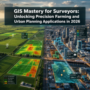
The property surveying industry stands at a pivotal crossroads in 2026. What was once a profession defined by measuring tapes, theodolites, and manual boundary mapping has evolved into a sophisticated discipline powered by predictive intelligence and advanced analytics. Data-Driven Property Surveying: How Analytics Transform Site Assessment and Risk Prediction in 2026 represents more than just technological advancement—it marks a fundamental shift in how surveyors, developers, and property managers approach site evaluation and investment decisions.
Modern surveyors no longer simply document what exists; they predict what will happen next. By leveraging cutting-edge technologies like mobile 3D mapping, artificial intelligence, and geographic information systems, today's surveying professionals transform raw field data into actionable intelligence that drives smarter development decisions and reduces financial risk.
Key Takeaways
- Mobile 3D mapping and GNSS RTK systems deliver 75% faster surveys while reducing costs by 40-60%, fundamentally accelerating project timelines[4]
- AI-powered analytics process massive datasets to identify structural patterns, detect changes, and predict future risks including flooding and landslides[2]
- Integrated technology platforms combining LiDAR, drones, GIS, and IoT sensors provide comprehensive site intelligence beyond traditional boundary documentation
- Predictive analytics enable proactive decision-making by forecasting market trends, property values, and potential site hazards before they materialize[1]
- The global business intelligence market for real estate is projected to reach $15.8 billion by 2032, reflecting widespread industry adoption[1]
The Evolution from Measurement to Intelligence
Traditional Surveying Limitations
Historically, property surveying focused on precise measurement and documentation. Surveyors would spend days or weeks on-site collecting data points, manually recording measurements, and producing static reports that captured a single moment in time. While accuracy remained paramount, these traditional methods offered limited insight into future conditions or comparative market analysis.
The process was labor-intensive, time-consuming, and expensive. Large development projects required substantial surveying budgets, and the resulting data often became outdated before construction even began. Property managers and developers made decisions based on historical snapshots rather than dynamic, forward-looking intelligence.
The Analytics Revolution
Data-Driven Property Surveying: How Analytics Transform Site Assessment and Risk Prediction in 2026 has fundamentally changed this paradigm. Modern surveying integrates multiple data sources—from satellite imagery and sensor networks to historical market trends and environmental monitoring—creating a comprehensive intelligence framework that supports predictive decision-making.
This transformation enables surveyors to answer questions that were previously impossible to address: Which properties face the highest flood risk over the next decade? How will proposed zoning changes affect property values in specific neighborhoods? What structural maintenance issues are likely to emerge based on building age, materials, and environmental exposure?
For property professionals seeking comprehensive site evaluation, understanding different types of survey options helps align assessment methods with specific project requirements.
Core Technologies Driving Data-Driven Property Surveying in 2026
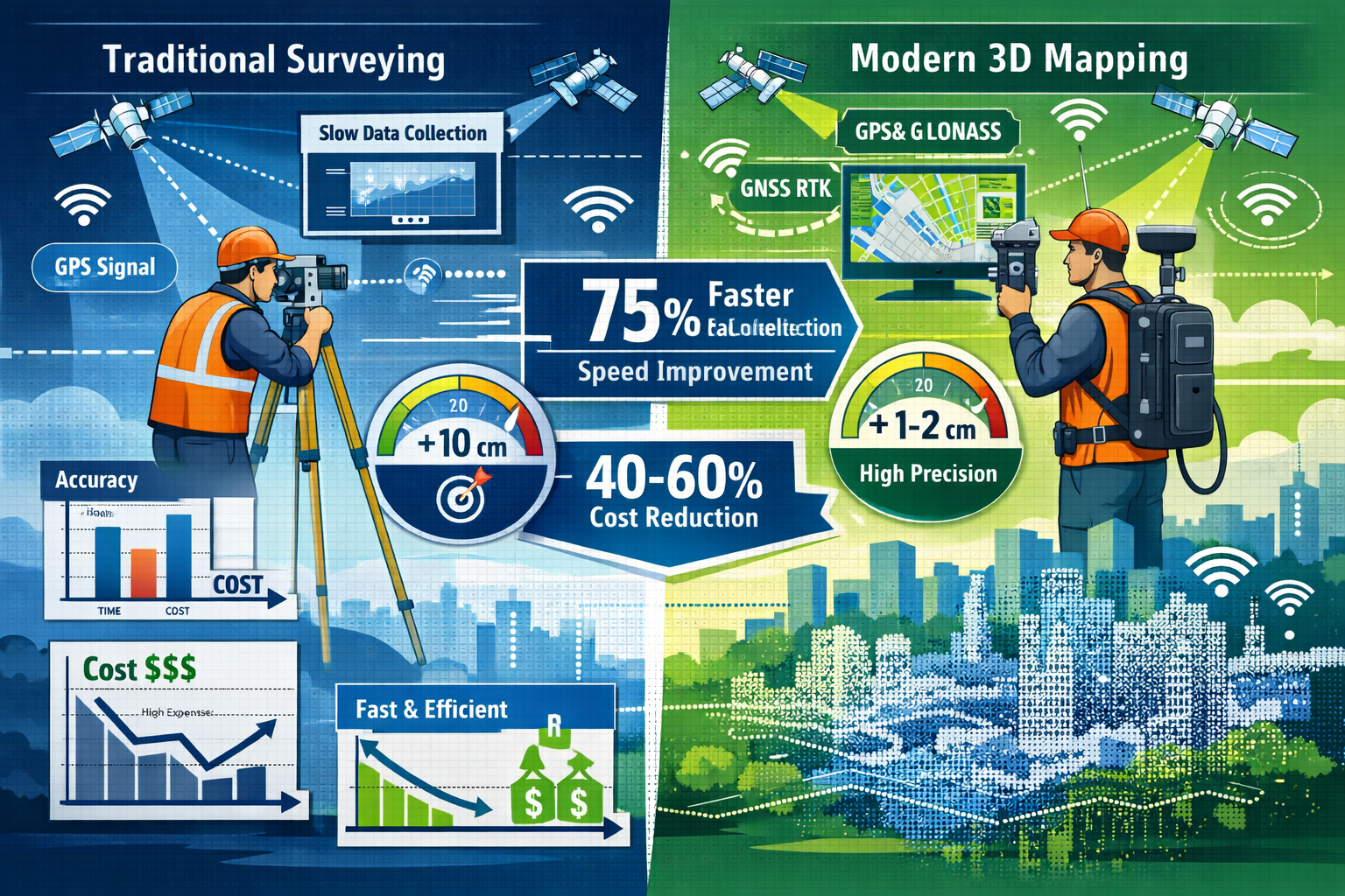
Mobile 3D Mapping and GNSS RTK Systems
Mobile 3D mapping combined with Global Navigation Satellite System Real-Time Kinematic (GNSS RTK) positioning represents one of the most significant advances in surveying efficiency. These systems deliver surveys 75% faster while reducing costs by 40-60% compared to traditional methods[4].
The technology works by mounting laser scanners and cameras on vehicles or backpack-mounted rigs that surveyors carry through properties. As they move, the system continuously captures millions of data points, creating detailed 3D models in real-time. GNSS RTK provides centimeter-level positioning accuracy by receiving correction signals from base stations, eliminating the cumulative errors that plague standard GPS systems.
Key advantages include:
- Rapid data collection across large sites without stationary equipment setup
- Comprehensive coverage of both indoor and outdoor environments
- Immediate visualization allowing surveyors to identify gaps during fieldwork
- Reduced site visits minimizing disruption to occupied properties
- Enhanced safety by reducing time spent in hazardous areas
LiDAR Mapping and 3D Laser Scanning
Light Detection and Ranging (LiDAR) technology has become increasingly accessible and portable in 2026. Modern LiDAR systems enable surveyors to create detailed digital replicas of indoor and outdoor environments without bulky equipment, substantially reducing collection time[2].
LiDAR works by emitting laser pulses and measuring the time it takes for reflected light to return. By capturing millions of measurements per second, the system generates precise point clouds—dense collections of spatial data points that form accurate 3D representations of structures, terrain, and vegetation.
These digital twins serve multiple purposes beyond initial assessment. Property managers use them for space planning, architects reference them for renovation designs, and insurance companies leverage them for accurate reinstatement valuations. The data remains valuable throughout a property's lifecycle, providing a baseline for monitoring structural changes over time.
Drone and UAV Applications
Unmanned Aerial Vehicles (UAVs) have expanded significantly in property surveying due to improved accessibility and reduced costs. Modern drones utilize real-time kinematics (RTK) and post-processing kinematic (PPK) positioning for enhanced accuracy in data collection[2].
Drones excel at capturing aerial perspectives that would be dangerous or impossible to obtain through traditional methods. They survey roof conditions, assess large development sites, monitor construction progress, and document environmental features like drainage patterns and vegetation coverage.
Advanced drone applications in 2026 include:
📸 Thermal imaging to detect heat loss, moisture intrusion, and insulation deficiencies
📊 Multispectral analysis for vegetation health and environmental assessment
🏗️ Progress monitoring with automated comparison against project timelines
🗺️ Volumetric calculations for earthwork and material quantity estimation
⚠️ Safety inspections of tall structures without scaffolding or climbing
Organizations conducting comprehensive property evaluations often integrate drone surveys with ground-based assessments for complete site intelligence.
Geographic Information Systems (GIS) Integration
Geographic Information Systems allow surveyors to overlay multiple datasets—including zoning information, property boundaries, utility locations, environmental constraints, and demographic trends—into single unified maps for enhanced pattern identification and analysis[2].
GIS transforms surveying from isolated data collection into contextual intelligence. A property boundary survey becomes more valuable when overlaid with flood zone maps, historical sales data, planned infrastructure projects, and neighborhood demographic shifts. This integrated approach reveals opportunities and risks that single-dataset analysis would miss.
Modern GIS platforms support sophisticated spatial analysis including:
- Proximity analysis identifying properties near amenities or hazards
- Trend mapping visualizing how property characteristics change across regions
- Network analysis optimizing routes for utility installation or service access
- Predictive modeling forecasting how proposed changes affect surrounding areas
- Scenario planning comparing potential development outcomes
Artificial Intelligence and Machine Learning
AI-powered machine learning algorithms process massive datasets to identify patterns, detect structural changes, and predict future developments. These systems show particular promise for risk assessment including flooding and landslide prediction, though predictive risk tools remain in early development stages[2].
Machine learning excels at recognizing subtle patterns across thousands of properties that human analysts might miss. By training on historical data—including property characteristics, maintenance records, environmental conditions, and incident reports—AI models learn to identify risk factors and predict likely outcomes.
Current applications include:
🔍 Anomaly detection flagging unusual structural features requiring investigation
📈 Valuation modeling predicting property values based on comparable sales and features
⚡ Defect prediction identifying likely maintenance issues before they become critical
🌊 Environmental risk scoring assessing flood, subsidence, and contamination probability
🏘️ Market forecasting predicting demand and price trends for specific property types
How Analytics Transform Site Assessment Workflows
From Static Reports to Dynamic Intelligence
Traditional surveying produced static reports—fixed documents capturing conditions at a specific moment. Data-Driven Property Surveying: How Analytics Transform Site Assessment and Risk Prediction in 2026 replaces these snapshots with dynamic intelligence platforms that continuously update as new information becomes available.
Modern assessment workflows integrate real-time data dashboards and automated alerts that have replaced static reporting, enabling organizations to proactively identify risks and opportunities across portfolios with faster response times to market changes[1].
Property managers receive instant notifications when sensor data indicates potential issues—rising moisture levels suggesting water intrusion, temperature anomalies indicating HVAC failures, or movement sensors detecting structural settlement. This proactive approach prevents minor issues from escalating into expensive emergencies.
Integrated Data Collection Strategies
Comprehensive site assessment in 2026 combines multiple data collection methods into integrated workflows:
Phase 1: Remote Assessment
- Satellite imagery analysis for site context
- Historical records review including previous surveys and planning documents
- Public data integration (zoning, utilities, environmental constraints)
- Preliminary risk screening using predictive models
Phase 2: On-Site Data Capture
- Mobile 3D mapping for rapid comprehensive coverage
- Drone surveys for aerial perspectives and roof assessment
- Targeted LiDAR scanning for complex structural areas
- IoT sensor installation for ongoing monitoring
Phase 3: Laboratory and Specialist Analysis
- Material testing for contamination or structural integrity
- Geotechnical investigation for foundation assessment
- Environmental sampling for regulatory compliance
- Specialist inspections for heritage or unique properties
Phase 4: Analytics and Intelligence Generation
- Data integration into unified GIS platform
- AI-powered pattern recognition and anomaly detection
- Predictive modeling for risk assessment and valuation
- Scenario analysis for development options
This integrated approach ensures comprehensive coverage while maximizing efficiency. For residential transactions, professionals often recommend a homebuyer survey as a cost-effective assessment that balances thoroughness with budget considerations.
Enhanced Accuracy and Reliability
Analytics-driven surveying significantly improves accuracy through multiple mechanisms:
Cross-validation comparing data from different sources (drone imagery, ground surveys, satellite data) to identify discrepancies and confirm findings. When multiple independent methods produce consistent results, confidence in the assessment increases substantially.
Automated quality control using algorithms to flag potential errors—measurements outside expected ranges, gaps in coverage, or inconsistencies between datasets. This catches mistakes that might escape manual review, especially in large projects with millions of data points.
Temporal analysis comparing current conditions against historical data to detect changes over time. Subtle structural movement, erosion, or vegetation encroachment becomes apparent when comparing surveys conducted months or years apart.
Probabilistic modeling quantifying uncertainty rather than presenting single-point estimates. Instead of stating "the property is worth £500,000," analytics-driven assessments might indicate "95% confidence the value falls between £485,000 and £515,000 based on comparable sales and property characteristics."
Risk Prediction: The Game-Changing Application
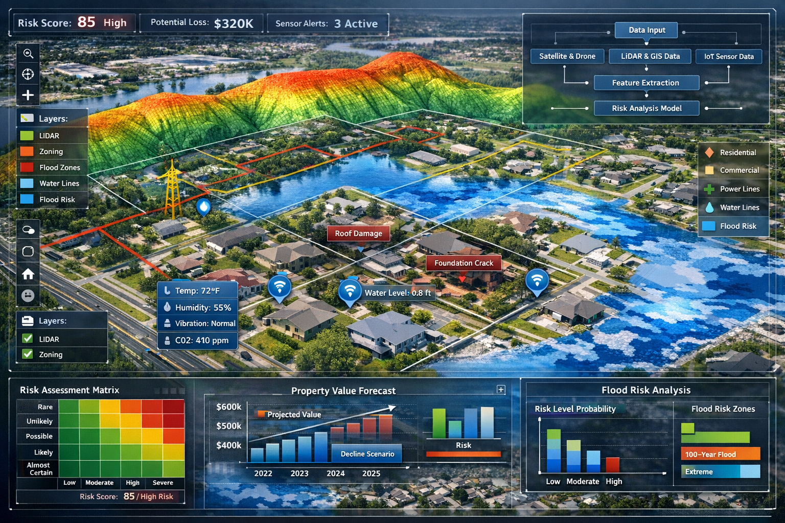
Environmental and Natural Hazard Assessment
Predictive analytics for environmental risks represents one of the most valuable applications of data-driven surveying. By combining topographic data, historical weather patterns, soil characteristics, and climate projections, modern systems forecast site-specific risks with unprecedented precision.
Flood risk prediction integrates multiple data sources:
- High-resolution elevation models identifying low-lying areas
- Watershed analysis modeling water flow during extreme rainfall
- Historical flood records documenting past events
- Climate projections estimating future precipitation patterns
- Infrastructure data showing drainage capacity and flood defenses
These models don't simply classify properties as "high risk" or "low risk." They estimate flood probability over specific timeframes (1-year, 10-year, 100-year events), predict likely water depths, and calculate potential damage costs. This granular intelligence supports better insurance pricing, development decisions, and mitigation planning.
Landslide and subsidence prediction similarly combines geological surveys, soil moisture monitoring, vegetation analysis, and historical incident data to identify unstable slopes and ground conditions. Properties in mining areas benefit from subsidence modeling that predicts likely settlement patterns based on historical extraction activities.
Structural Condition Forecasting
Beyond environmental hazards, analytics predict structural deterioration and maintenance needs. IoT and smart building system integration provides real-time sensor data for energy management, predictive maintenance, and tenant experience optimization, supporting operational cost reduction and sustainability improvements[1].
Sensors throughout buildings monitor:
🌡️ Temperature and humidity affecting material degradation rates
📊 Vibration patterns indicating mechanical equipment wear
💧 Moisture levels revealing water intrusion before visible damage
⚡ Energy consumption identifying inefficient systems
🏗️ Structural movement detecting settlement or load-related stress
Machine learning models analyze this continuous data stream alongside building age, construction quality, maintenance history, and environmental exposure to predict when components will require repair or replacement. Property managers receive advance warning—"the HVAC system shows degradation patterns suggesting failure within 6-12 months"—allowing planned maintenance rather than emergency repairs.
For properties undergoing significant changes, a schedule of condition provides baseline documentation that supports future condition monitoring and dispute resolution.
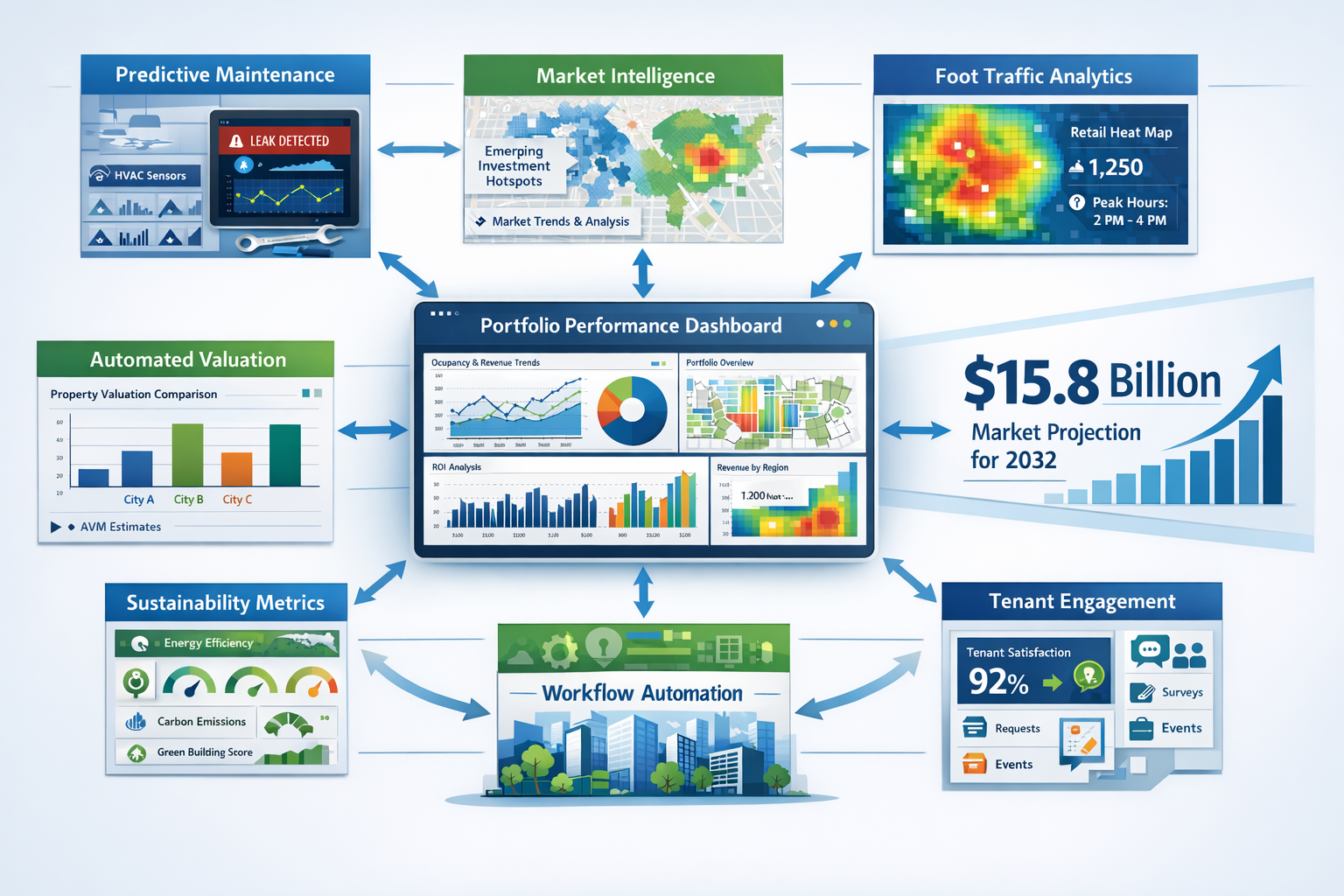
Market Risk and Investment Analysis
Data-Driven Property Surveying: How Analytics Transform Site Assessment and Risk Prediction in 2026 extends beyond physical site characteristics to encompass market dynamics and investment risk.
Predictive analytics leverages historical and live data to forecast demand, spot emerging investment hotspots, and anticipate price fluctuations before they materialize, supporting proactive strategy adjustments[1].
Modern property assessment integrates market intelligence including:
- Demographic trends showing population growth, age distribution, and income levels
- Economic indicators tracking employment, business formation, and income growth
- Development pipelines documenting planned projects affecting supply
- Transportation projects identifying areas gaining accessibility
- Retail and amenity changes showing neighborhood evolution
By analyzing these factors alongside property-specific data, predictive models forecast likely value appreciation or depreciation. Developers identify undervalued areas poised for growth, while investors spot markets approaching saturation before prices peak.
Foot traffic analytics and location intelligence provide granular consumer behavior data to optimize site selection and asset performance analysis, helping stakeholders make data-driven decisions on property positioning[1]. Retail developers use pedestrian flow patterns, dwell times, and demographic profiles to select optimal locations and predict sales performance.
Property Valuation Transformation Through Analytics
Automated Valuation Models (AVMs)
Property valuation systems now integrate diverse datasets through automated valuation models and interactive dashboards, enabling real-time comparison across properties and regions, with leading firms' automated approaches outperforming traditional appraisals in certain applications[1].
AVMs use statistical modeling and machine learning to estimate property values based on:
- Comparable sales with sophisticated similarity algorithms
- Property characteristics including size, age, condition, and features
- Location factors such as school quality, crime rates, and amenities
- Market trends showing price movements over time
- Economic indicators affecting local property demand
While AVMs don't replace professional valuations for complex or unique properties, they provide rapid preliminary estimates and support portfolio-level analysis where individual appraisals would be impractical. Investment funds managing thousands of properties use AVMs for continuous portfolio valuation, flagging properties requiring detailed revaluation when estimates diverge significantly from model predictions.
For regulatory compliance and specific transaction types, RICS-certified professionals provide valuation reports that meet industry standards and legal requirements.
Comparative Market Analysis at Scale
Traditional comparative market analysis involved manually identifying similar properties and adjusting for differences—a time-consuming process limiting the number of comparables considered. Analytics platforms automatically identify relevant comparables from databases containing millions of properties, applying sophisticated algorithms to account for differences.
Advanced matching algorithms consider:
| Factor Category | Specific Attributes |
|---|---|
| Physical Characteristics | Size, bedrooms, bathrooms, construction quality, age, condition |
| Location Attributes | Neighborhood, school district, proximity to amenities, views |
| Market Timing | Sale date, market conditions, seasonal factors |
| Transaction Type | Arms-length sale, foreclosure, family transfer, developer sale |
| Unique Features | Historical significance, architectural style, special amenities |
The system weights each factor based on its impact on value, producing more accurate comparisons than simple per-square-foot calculations. Interactive dashboards allow valuers to explore different comparable sets, understanding how selection criteria affect estimated values.
Risk-Adjusted Valuation
Beyond estimating current market value, analytics enable risk-adjusted valuation that accounts for future uncertainties. Properties facing environmental hazards, regulatory changes, or market volatility receive valuations reflecting these risks.
A coastal property might show strong current market value but face significant long-term risk from sea-level rise and increased storm intensity. Risk-adjusted valuation quantifies this exposure, providing a more complete picture for long-term investors. Similarly, properties in areas with proposed zoning changes receive valuations reflecting both current use and potential future development scenarios.
This approach proves particularly valuable for institutional investors managing multi-decade hold periods, where current market conditions represent just one factor in total return calculations.
Implementation Strategies for Property Professionals
Building Integrated Technology Stacks
Integrated property management platforms combining analytics dashboards, predictive maintenance tools, market intelligence platforms, and tenant engagement systems provide property managers with real-time portfolio performance visibility[3].
Successful implementation requires thoughtful technology selection and integration:
Core Platform Selection
Choose a central property management system that serves as the data hub, integrating information from specialized tools. The platform should support open APIs (Application Programming Interfaces) allowing seamless data exchange with other systems.
Specialized Tool Integration
Add specialized capabilities for specific needs:
- Survey data management for storing and analyzing LiDAR scans and 3D models
- GIS platforms for spatial analysis and mapping
- Predictive analytics engines for risk modeling and forecasting
- IoT platforms for sensor data collection and monitoring
- Market intelligence services for competitive analysis
Data Governance Framework
Establish clear protocols for data quality, security, and access:
- Quality standards ensuring accuracy and completeness
- Update frequencies keeping information current
- Access controls protecting sensitive information
- Backup procedures preventing data loss
- Compliance measures meeting regulatory requirements
Developing Analytics Capabilities
Technology alone doesn't deliver value—organizations need people who can interpret data and translate insights into decisions. Building analytics capabilities requires:
Skills Development
- Training existing staff in data interpretation and analytics tools
- Hiring specialists with GIS, data science, or analytics backgrounds
- Partnering with consultants for specialized analysis
- Creating cross-functional teams combining domain expertise with technical skills
Process Integration
- Embedding analytics into standard workflows rather than treating it as separate activity
- Establishing regular reporting rhythms for portfolio performance review
- Creating feedback loops where decisions inform model refinement
- Documenting successful approaches for organizational learning
Culture Change
- Promoting data-driven decision-making over intuition alone
- Encouraging experimentation and learning from analytics insights
- Celebrating successes achieved through analytics applications
- Building comfort with probabilistic thinking and uncertainty quantification
Selecting the Right Assessment Approach
Not every property requires the full suite of advanced analytics. Matching assessment intensity to project requirements optimizes cost-effectiveness. Understanding which survey you need helps align methodology with specific circumstances.
Decision Framework:
Basic Analytics (Lower-value residential, straightforward sites)
- Automated valuation models for preliminary estimates
- Standard comparable sales analysis
- Basic environmental screening using public databases
- Visual inspection with photographic documentation
Intermediate Analytics (Mid-value commercial, complex residential)
- Professional valuation with enhanced comparables analysis
- Drone surveys for comprehensive site documentation
- GIS analysis for location intelligence
- Targeted sensor monitoring for specific concerns
Advanced Analytics (High-value assets, complex developments)
- Full 3D scanning and digital twin creation
- Comprehensive IoT sensor networks
- Predictive modeling for multiple risk scenarios
- Ongoing monitoring with automated alerts
- Custom market analysis and forecasting
Specialized Analytics (Unique properties, regulatory requirements)
- Heritage building documentation and conservation planning
- Environmental contamination assessment and remediation modeling
- Complex valuation scenarios (matrimonial, tax, compulsory purchase)
- Expert witness reporting for litigation support
For commercial properties requiring detailed assessment, commercial building surveys provide comprehensive evaluation of structural condition, building services, and regulatory compliance.
Industry Applications and Use Cases
Residential Development
Residential developers use analytics throughout the project lifecycle:
Site Selection: Predictive models identify areas with strong demographic trends, limited supply, and favorable planning environments. Foot traffic analysis reveals neighborhood vitality, while school quality and amenity proximity data inform target market alignment.
Feasibility Assessment: Comprehensive site surveys combining topographic data, geotechnical investigation, utility availability, and environmental constraints feed into development cost models. Risk prediction identifies potential issues (contamination, flooding, access limitations) affecting project viability.
Design Optimization: 3D site models support architectural design, ensuring buildings optimize views, solar exposure, and site characteristics. Market analytics inform unit mix decisions based on local demand patterns.
Sales and Marketing: Virtual property tours using 3D scans allow remote viewing, while location intelligence data supports marketing messaging highlighting neighborhood amenities and growth prospects.
Commercial Real Estate Investment
Institutional investors managing large portfolios leverage analytics for:
Acquisition Due Diligence: Comprehensive property assessment combining physical surveys, market analysis, tenant evaluation, and risk modeling informs purchase decisions. Automated valuation models provide preliminary screening, with detailed professional valuations for shortlisted properties.
Portfolio Optimization: Continuous monitoring of portfolio performance identifies underperforming assets requiring intervention or disposal. Predictive analytics forecast future performance under different scenarios, supporting strategic planning.
Asset Management: IoT sensor networks monitor building performance, identifying maintenance needs and energy efficiency opportunities. Tenant satisfaction data from smart building systems informs retention strategies.
Disposition Strategy: Market intelligence platforms identify optimal timing for asset sales, while comprehensive property documentation (3D scans, condition reports, performance data) supports marketing to potential buyers.
Property Management and Operations
Property managers use analytics for day-to-day operations:
Preventive Maintenance: Predictive models forecast equipment failures, allowing planned maintenance rather than emergency repairs. Sensor data tracks building system performance, triggering alerts when parameters exceed normal ranges.
Energy Management: Detailed energy consumption data identifies inefficient systems and optimization opportunities. Building performance modeling quantifies potential savings from upgrades, supporting investment decisions.
Tenant Services: Smart building systems track space utilization, environmental conditions, and service requests, enabling responsive management. Analytics identify patterns in tenant concerns, informing service improvements.
Regulatory Compliance: Automated monitoring ensures compliance with safety regulations, environmental standards, and accessibility requirements. Documentation systems maintain comprehensive records supporting audit responses.
For properties requiring specialized assessment, professionals provide RICS building surveys that meet rigorous professional standards for comprehensive property evaluation.
Infrastructure and Public Sector
Government agencies and infrastructure developers apply analytics to:
Transportation Planning: Traffic flow analysis, demographic projections, and development patterns inform infrastructure investment decisions. Environmental impact modeling predicts effects of proposed projects.
Utility Management: Underground utility mapping using ground-penetrating radar and GIS integration prevents damage during construction. Predictive maintenance models optimize infrastructure replacement timing.
Public Asset Management: Comprehensive inventories of public buildings, parks, and facilities support maintenance planning and capital budgeting. Condition monitoring identifies deterioration requiring intervention.
Emergency Planning: Flood modeling, evacuation route analysis, and critical infrastructure mapping support disaster preparedness. Real-time monitoring during events enables rapid response coordination.
Challenges and Considerations
Data Quality and Integration
The value of analytics depends entirely on data quality. Poor quality data produces misleading insights that can drive bad decisions—a phenomenon known as "garbage in, garbage out."
Common data quality challenges:
❌ Incomplete coverage with gaps in spatial data or missing property attributes
❌ Outdated information that doesn't reflect current conditions
❌ Inconsistent formats making integration difficult
❌ Accuracy issues from measurement errors or incorrect classification
❌ Duplicate records creating confusion and inflated counts
Addressing these challenges requires:
✅ Standardized data collection protocols ensuring consistency
✅ Regular validation comparing datasets against ground truth
✅ Clear metadata documenting data sources, collection methods, and update dates
✅ Integration frameworks translating between different data formats
✅ Quality metrics tracking accuracy and completeness over time
Privacy and Security Concerns
Comprehensive property data collection raises privacy considerations. Detailed 3D scans of buildings, occupancy patterns from sensors, and integrated personal information require careful handling.
Key considerations:
🔒 Data minimization collecting only information necessary for legitimate purposes
🔒 Access controls limiting data availability to authorized users
🔒 Anonymization removing personally identifiable information where possible
🔒 Secure storage protecting data from unauthorized access or breaches
🔒 Regulatory compliance meeting GDPR and other privacy requirements
🔒 Transparent communication informing stakeholders about data collection and use
Technology Investment and ROI
Advanced analytics capabilities require significant investment in technology, training, and process development. Organizations must carefully evaluate return on investment.
Cost considerations:
- Hardware (drones, scanners, sensors, computing infrastructure)
- Software licenses (GIS platforms, analytics tools, data management systems)
- Training and skills development
- Data acquisition and integration
- Ongoing maintenance and updates
Value drivers:
- Faster project delivery reducing time costs
- Improved accuracy preventing costly mistakes
- Better decision-making increasing investment returns
- Risk mitigation avoiding expensive problems
- Competitive advantage winning more business
The global business intelligence market for real estate projected to reach $15.8 billion by 2032 reflects widespread industry recognition that analytics investment delivers substantial returns[1].
Skills Gap and Change Management
Many property professionals trained in traditional methods face learning curves adopting analytics approaches. Organizations must manage this transition thoughtfully:
Resistance sources:
- Comfort with familiar methods
- Skepticism about new technology reliability
- Concern about job displacement
- Lack of confidence in technical skills
Change management strategies:
- Demonstrating value through pilot projects
- Providing comprehensive training and support
- Celebrating early adopters and success stories
- Maintaining hybrid approaches during transition
- Emphasizing how technology augments rather than replaces professional judgment
Future Directions and Emerging Trends
Artificial Intelligence Advancement
While AI applications in property surveying show tremendous promise, many predictive capabilities remain in early development stages[2]. Future advancement will likely focus on:
Enhanced prediction accuracy as models train on larger datasets spanning longer timeframes, improving forecasts for property values, maintenance needs, and environmental risks.
Automated anomaly detection identifying subtle structural issues, market irregularities, or fraud indicators that human analysts might miss in large datasets.
Natural language processing extracting insights from unstructured data including planning documents, legal descriptions, historical records, and tenant feedback.
Computer vision advancement automatically identifying property features, condition issues, and compliance concerns from photographs and video, reducing manual inspection time.
Digital Twin Maturity
Digital twins—comprehensive virtual replicas of physical properties—will evolve from static 3D models to dynamic simulations incorporating real-time sensor data, predictive models, and scenario analysis.
Future capabilities:
- Real-time performance monitoring with automated optimization
- Predictive simulation testing renovation scenarios before implementation
- Lifecycle management tracking property evolution from construction through demolition
- Integration with smart city platforms for neighborhood-scale analysis
Blockchain and Distributed Ledgers
Blockchain technology may transform property data management by creating immutable records of surveys, valuations, transactions, and modifications. This could:
- Reduce fraud by creating verifiable property histories
- Streamline transactions by providing trusted data to all parties
- Enable automated compliance verification
- Support fractional ownership and investment tokenization
Sustainability and Climate Analytics
Growing focus on environmental sustainability and climate risk will drive analytics development:
Carbon footprint modeling quantifying building emissions and optimization opportunities
Climate resilience assessment evaluating long-term viability under different climate scenarios
Green certification optimization identifying cost-effective paths to sustainability standards
Circular economy integration tracking material reuse and lifecycle impacts
Properties will increasingly be valued not just on current income but on environmental performance and climate resilience.
Augmented Reality Integration
Augmented reality (AR) will overlay digital information onto physical environments during site visits:
- Surveyors viewing underground utilities through AR glasses while walking sites
- Property boundaries and setback requirements visible during site inspection
- Historical photographs overlaid on current views showing changes over time
- Maintenance instructions appearing when viewing building equipment
- Structural stress analysis visible when examining building components
Conclusion: Embracing the Analytics Revolution
Data-Driven Property Surveying: How Analytics Transform Site Assessment and Risk Prediction in 2026 represents far more than technological novelty—it fundamentally reshapes how property professionals understand, evaluate, and manage real estate assets. The integration of mobile 3D mapping, artificial intelligence, drone technology, GIS platforms, and IoT sensors creates intelligence capabilities that were unimaginable just a decade ago.
The benefits extend across the property lifecycle:
🎯 Developers identify optimal sites, assess feasibility accurately, and manage construction risks
💼 Investors make better acquisition decisions with comprehensive risk assessment
🏢 Property managers optimize operations through predictive maintenance and performance monitoring
📊 Valuers produce more accurate assessments incorporating market dynamics and risk factors
🏗️ Surveyors deliver faster, more comprehensive assessments at lower cost
Yet technology alone doesn't create value. Success requires thoughtful implementation that combines advanced tools with professional expertise, sound judgment, and ethical practice. The most effective approaches integrate analytics into comprehensive workflows that leverage both computational power and human insight.
Actionable Next Steps
For property professionals looking to embrace data-driven surveying:
1. Assess Current Capabilities
Evaluate existing technology, skills, and processes to identify gaps and opportunities. Understanding your starting point informs realistic implementation planning.
2. Start with Targeted Pilots
Rather than attempting comprehensive transformation immediately, implement focused pilot projects demonstrating value and building organizational confidence. Success breeds support for broader adoption.
3. Invest in Skills Development
Technology without capable users delivers limited value. Prioritize training and development, building analytics literacy across your organization.
4. Build Strategic Partnerships
Few organizations possess all required capabilities internally. Partner with technology providers, data specialists, and RICS-certified professionals who bring complementary expertise.
5. Establish Data Governance
Create clear frameworks for data quality, security, and use before problems emerge. Strong governance foundations support sustainable analytics programs.
6. Focus on Decision Impact
Technology and data are means to an end—better decisions driving better outcomes. Continuously evaluate whether analytics initiatives actually improve decision quality and business results.
7. Stay Informed on Emerging Trends
The analytics landscape evolves rapidly. Maintain awareness of new capabilities, industry best practices, and regulatory developments affecting property surveying.
The transformation toward data-driven property surveying isn't optional—it's inevitable. Organizations that embrace analytics thoughtfully will gain competitive advantages through faster delivery, better accuracy, and superior risk management. Those that resist will find themselves increasingly disadvantaged as clients demand the insights that analytics enable.
The future of property surveying combines the precision and professionalism that have always defined the discipline with powerful new capabilities for prediction, optimization, and intelligence generation. By transforming raw data into actionable insights, modern surveyors don't just document properties—they illuminate possibilities and predict futures, supporting smarter decisions that create better outcomes for all stakeholders in the built environment.
References
[1] Data Analytics Real Estate – https://leni.co/help-articles/data-analytics-real-estate/
[2] The Future Of Land Surveying Technology And Upcoming Trends In 2026 – https://metricop.com/blogs/land-surveying/the-future-of-land-surveying-technology-and-upcoming-trends-in-2026
[3] Data Driven Decision Making Property Managers – https://bfpminc.com/data-driven-decision-making-property-managers/
[4] The Future Of Land Surveying Technology 2026 Trends In Mobile 3d Mapping And Gnss Rtk Systems – https://nottinghillsurveyors.com/blog/the-future-of-land-surveying-technology-2026-trends-in-mobile-3d-mapping-and-gnss-rtk-systems