}

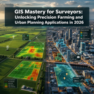
The surveying profession stands at a pivotal moment in 2026. Imagine a surveyor returning from the field with terabytes of raw LiDAR data—a task that once required weeks of painstaking manual analysis. Today, AI-driven automation in land surveying processes that same data in minutes, automatically distinguishing between vegetation, buildings, and terrain features with remarkable precision. This transformation isn't science fiction; it's the new reality reshaping how professionals capture, process, and deliver spatial data. As workforce shortages intensify and client expectations evolve, AI-driven automation in land surveying: how machine learning is transforming workflows has emerged as the defining trend of the decade, fundamentally changing what surveyors do and how they add value.
The convergence of artificial intelligence, autonomous systems, and cloud-based platforms is shifting the surveyor's role from data processor to strategic advisor. Rather than spending countless hours cleaning point clouds or manually identifying features, professionals now leverage machine learning algorithms that instantly classify terrain, flag anomalies, and generate actionable insights. This allows surveyors to focus their expertise where it matters most: interpreting complex results, ensuring legal compliance, and solving challenging field problems that require human judgment.
Key Takeaways
🎯 Instant Data Processing: AI algorithms can analyze LiDAR point clouds in real-time, reducing processing times from weeks to minutes while automatically classifying vegetation, buildings, and terrain features with minimal human intervention[1].
🚁 Autonomous Operations: Machine learning-enabled drones can now survey hundreds of acres autonomously, adjusting flight paths, avoiding obstacles, and identifying areas of interest without constant human control[1].
📊 Predictive Risk Analysis: AI-powered predictive analytics combine historical survey data with environmental factors to anticipate geological changes, land deformations, and infrastructure risks including subsidence, landslides, and soil erosion[1].
⚙️ Equipment Intelligence: Digital twin technology and AI sensors monitor survey equipment performance in real-time, predicting potential failures before they occur and optimizing maintenance schedules[1].
💼 Democratized Technology: Automated workflows and reduced costs make advanced surveying capabilities accessible to smaller firms that previously couldn't afford sophisticated UAV and data processing systems[1].
Understanding AI-Driven Automation in Land Surveying: How Machine Learning is Transforming Workflows
The Foundation of Machine Learning in Surveying
Artificial intelligence and machine learning represent distinct but complementary technologies reshaping the surveying landscape. While AI encompasses the broader concept of machines performing tasks that typically require human intelligence, machine learning specifically refers to algorithms that improve through experience—learning patterns from data without explicit programming.
In the surveying context, these technologies work together to create systems that:
- Recognize patterns in spatial data that would take humans days or weeks to identify
- Adapt and improve accuracy as they process more survey datasets
- Make autonomous decisions about data collection and processing parameters
- Predict outcomes based on historical trends and environmental variables
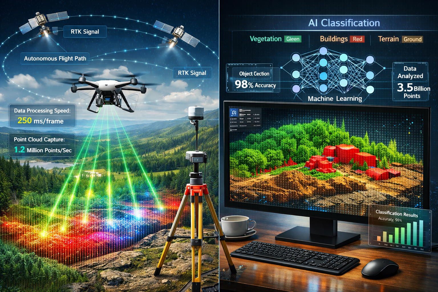
The practical application begins with data capture. Modern surveying employs various sensors and platforms:
| Technology | AI Enhancement | Key Benefit |
|---|---|---|
| LiDAR Scanners | Automatic point cloud classification | 90% reduction in processing time[1] |
| UAV/Drones | Autonomous flight path optimization | Survey hundreds of acres per flight[1] |
| GNSS Systems | RTK/PPK positioning integration | Centimeter-level accuracy[2] |
| Mobile Mapping | Real-time feature extraction | Instant topographic processing[1] |
| Fixed Sensors | Continuous monitoring and alerts | Predictive risk identification[1] |
How AI Processes Survey Data Differently
Traditional surveying workflows required surveyors to manually review captured data, identify features, remove noise, and classify elements—a labor-intensive process prone to inconsistencies. AI-driven automation fundamentally changes this paradigm through several mechanisms:
Automated Feature Recognition: Machine learning models trained on millions of survey datasets can instantly identify roads, buildings, vegetation, water bodies, and terrain features within point clouds. The algorithms recognize geometric patterns, spectral signatures, and spatial relationships that define each feature type[1].
Intelligent Data Cleaning: AI-powered tools automatically detect and eliminate inconsistencies, outliers, and noise in survey data. These systems identify vegetation that should be filtered from ground measurements, remove atmospheric interference from aerial surveys, and flag questionable data points for human review[1].
Contextual Understanding: Advanced algorithms don't just classify individual points—they understand context. The system recognizes that a flat surface at ground level near a road is likely a sidewalk, while a similar surface elevated and adjacent to walls represents a building roof.
This contextual awareness enables surveyors to generate precise topographic maps that planners and engineers can use immediately, without extensive post-processing. For professionals seeking to understand which survey do you need for specific projects, these AI capabilities increasingly influence the selection criteria and deliverable expectations.
The Current State of Digital Transformation
As of February 2026, the surveying profession is experiencing accelerating digital transformation driven by multiple converging pressures[6]. The industry faces:
- Workforce shortages requiring fewer professionals to handle increasing workloads
- Client demands for faster turnaround times and more detailed deliverables
- Competitive pressure from firms leveraging advanced automation
- Regulatory evolution requiring more comprehensive documentation
The convergence of AI, cloud-based collaboration platforms, and interoperable hardware and software is fundamentally reshaping how spatial data is captured, processed, and shared[6]. This transformation extends beyond individual tools to encompass entire workflow ecosystems where data flows seamlessly from field capture through AI processing to final deliverable generation.
Initiatives like the ALTA Land Survey Automation Challenge—a $100,000 competition seeking solutions to expedite real estate and financing transactions—demonstrate the industry's commitment to automation[5]. With Concept Phase winners scheduled for announcement in mid-April 2026, these developments signal mainstream adoption rather than experimental exploration[5].
Real-Time Data Processing and Autonomous Operations
The Speed Revolution in Survey Data Processing
The most immediately visible impact of AI-driven automation in land surveying manifests in processing speed. Traditional workflows measured data processing timelines in days or weeks; AI-enhanced systems deliver results in near-real-time[1].
This transformation occurs through several technological advances:
Parallel Processing Architecture: Modern AI systems leverage GPU acceleration and distributed computing to analyze multiple data streams simultaneously. A drone capturing LiDAR data while flying can now process that information onboard, classifying terrain features before landing.
Edge Computing Integration: Rather than transmitting all raw data to central servers for processing, AI algorithms increasingly run on field devices themselves. This "edge computing" approach reduces bandwidth requirements, accelerates results, and enables offline operation in remote locations.
Adaptive Algorithms: Machine learning models optimize their own processing parameters based on data characteristics. When surveying dense urban environments, the system automatically adjusts classification thresholds differently than when processing open agricultural land.
The practical implications are substantial. Projects that previously required a survey team to capture data over several days, followed by weeks of office processing, now deliver preliminary results while crews are still in the field. This enables:
- Immediate quality verification ensuring complete coverage before leaving the site
- Real-time client collaboration with stakeholders reviewing results during data capture
- Rapid decision-making for construction and development projects with tight timelines
- Iterative refinement allowing surveyors to identify and resurvey problem areas immediately
For firms conducting building surveys or structural engineering assessments, this speed enables more comprehensive analysis within existing project budgets.
Autonomous UAV Operations and Intelligent Flight Systems
Autonomous drones represent perhaps the most visible manifestation of AI in surveying. While UAVs have been used for aerial data capture for years, 2026 marks the maturation of truly autonomous operations where human pilots serve as supervisors rather than active controllers[1].
Modern AI-enabled surveying drones incorporate:
Intelligent Flight Planning: Machine learning algorithms analyze project requirements, terrain characteristics, weather conditions, and regulatory constraints to generate optimal flight paths. The system determines ideal altitude, overlap percentages, camera angles, and flight speed without human input.
Dynamic Obstacle Avoidance: Computer vision systems continuously scan the flight environment, identifying and avoiding obstacles in real-time. Unlike simple collision detection, these AI systems predict the movement of dynamic obstacles (birds, other aircraft, construction equipment) and adjust trajectories proactively.
Adaptive Data Collection: Perhaps most impressively, autonomous systems can identify areas requiring additional attention during flight. If the AI detects incomplete coverage, poor lighting conditions, or features of interest, it autonomously adjusts the flight plan to capture supplementary data.
Multi-Drone Coordination: Advanced systems coordinate multiple UAVs surveying the same site simultaneously, optimizing coverage while maintaining safe separation distances. This "swarm intelligence" can survey hundreds of acres in a single coordinated operation[1].
The combination of autonomous flight and onboard AI processing creates a powerful capability: surveyors can deploy drones that independently capture, process, and deliver topographic data with minimal human intervention. This doesn't eliminate the need for professional oversight—surveyors remain essential for mission planning, quality assurance, and regulatory compliance—but it dramatically multiplies their productivity.
Enhanced Positioning Accuracy Through AI Integration
Positioning accuracy has always been fundamental to surveying, and AI enhances this critical capability through several mechanisms. Modern systems integrate real-time kinematics (RTK) and post-processing kinematic (PPK) positioning systems with machine learning algorithms to achieve unprecedented precision[2].
Intelligent Error Correction: AI algorithms analyze positioning data streams to identify and correct errors caused by atmospheric interference, multipath signals, or satellite geometry. The systems learn typical error patterns for specific locations and conditions, applying corrections automatically.
Sensor Fusion: Machine learning models combine data from multiple positioning sources—GNSS satellites, inertial measurement units (IMUs), visual odometry, and ground control points—to produce more reliable positions than any single source could provide. The AI weighs each input based on real-time reliability assessments.
Predictive Accuracy Modeling: Rather than simply reporting positions, AI-enhanced systems provide confidence intervals and accuracy predictions for each measurement. This allows surveyors to make informed decisions about whether additional measurements are needed for critical features.
These positioning enhancements prove particularly valuable for professionals conducting boundary surveys or schedule of condition reporting where precise measurements carry legal implications.
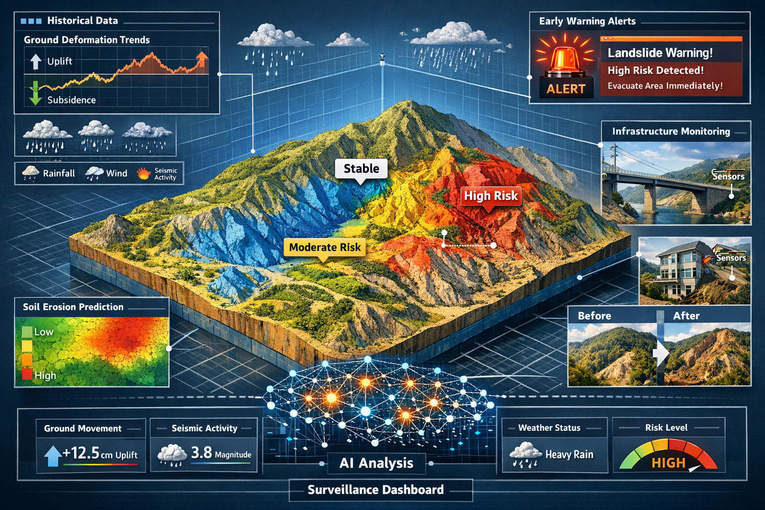
Predictive Analytics and Risk Management in AI-Driven Automation
Geological Prediction and Environmental Monitoring
Beyond processing existing data, AI-driven automation in land surveying: how machine learning is transforming workflows extends to predicting future conditions—a capability that transforms surveyors from documentarians of current conditions to advisors on future risks[1].
Predictive analytics powered by machine learning analyzes historical survey data combined with environmental factors to anticipate:
- Geological changes including ground subsidence and uplift
- Land deformations from natural settling or human activity
- Infrastructure risks such as foundation movement or structural stress
- Soil erosion patterns threatening stability or property boundaries
- Landslide susceptibility based on slope, soil composition, and precipitation
- Flood risk evolution as terrain and drainage patterns change
The predictive process works by training machine learning models on historical datasets that include:
- Temporal survey data showing how specific sites changed over months or years
- Environmental variables including precipitation, temperature, seismic activity, and groundwater levels
- Soil and geological characteristics from previous investigations
- Infrastructure loading from buildings, traffic, and construction activities
- Vegetation changes affecting soil stability and water retention
These models identify subtle patterns that precede significant changes. For example, the AI might detect that specific combinations of rainfall, soil type, and slope angle consistently precede landslides within 6-12 months. When current conditions match these patterns, the system generates early warnings.
Early warning systems remain in early development stages but show considerable promise[2]. Current applications include:
- Continuous monitoring of critical infrastructure sites with fixed sensors
- Periodic resurvey analysis comparing current conditions to baseline predictions
- Anomaly detection flagging unexpected changes requiring investigation
- Risk scoring quantifying the probability and potential impact of various hazards
For professionals conducting subsidence surveys or assessing properties with potential stability issues, these predictive capabilities provide valuable insights for clients making long-term investment decisions.
Predictive Maintenance for Survey Equipment
AI's predictive capabilities extend beyond terrain analysis to the equipment surveyors depend on. Digital twin technology and AI sensors are revolutionizing equipment maintenance and lifecycle management[1].
Real-Time Equipment Monitoring: Modern survey instruments increasingly incorporate sensors that continuously monitor:
- Performance metrics including accuracy, calibration drift, and measurement consistency
- Environmental stress from temperature extremes, humidity, vibration, and shock
- Component wear in motors, bearings, lenses, and electronic systems
- Battery health predicting remaining capacity and degradation rates
- Data quality indicators flagging potential sensor malfunctions
Digital Twin Modeling: AI-driven digital twins create virtual replicas of physical survey equipment, simulating their behavior under various conditions. These models provide insights into:
- Optimal usage patterns that minimize wear while maximizing productivity
- Maintenance scheduling based on actual usage rather than arbitrary time intervals
- Failure prediction identifying components likely to fail before they do
- Performance optimization suggesting configuration changes for specific applications
The practical benefits are substantial:
✅ Minimized downtime from unexpected equipment failures disrupting project schedules
✅ Extended equipment lifespan through optimized maintenance and usage patterns
✅ Reduced maintenance costs by performing service only when actually needed
✅ Improved data quality by identifying sensor degradation before it affects results
For surveying firms managing fleets of drones, GNSS systems, and LiDAR scanners, these predictive maintenance capabilities represent significant operational improvements and cost savings.
Risk Assessment and Project Planning
AI-enhanced risk assessment extends beyond geological hazards to encompass project-level planning and execution risks. Machine learning models trained on thousands of completed surveying projects can predict:
Timeline Risks: Analyzing project characteristics, site conditions, weather forecasts, and resource availability to predict realistic completion timelines and identify factors likely to cause delays.
Budget Risks: Identifying projects with characteristics associated with cost overruns, allowing surveyors to adjust estimates or implement additional controls.
Quality Risks: Flagging conditions that historically correlate with data quality issues, enabling proactive mitigation strategies.
Safety Risks: Analyzing site characteristics to identify potential hazards requiring special precautions or equipment.
These predictive insights help surveyors provide more accurate proposals, set realistic client expectations, and allocate resources effectively. When combined with traditional professional judgment, AI-enhanced risk assessment creates a powerful planning capability.
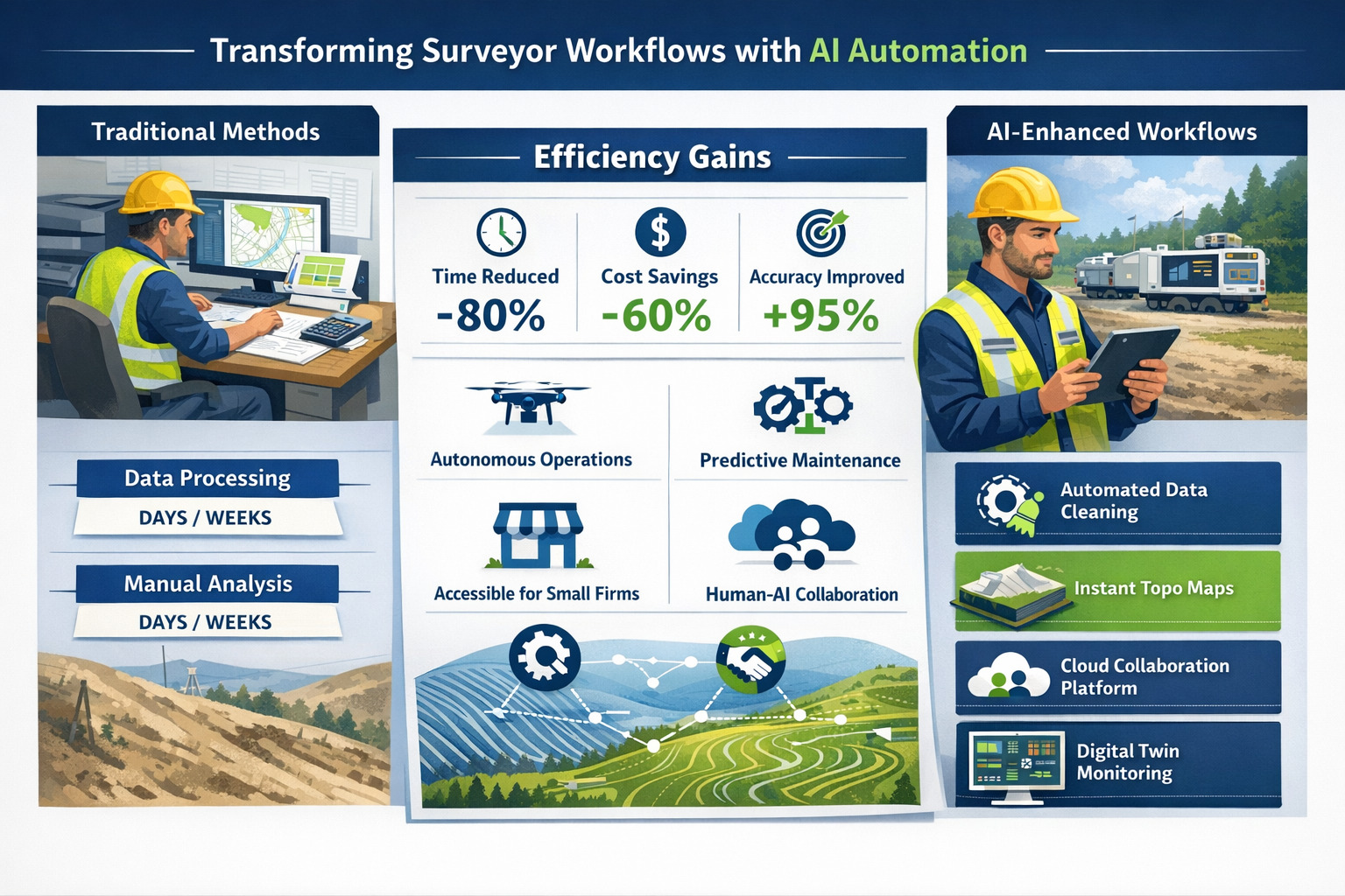
Workflow Transformation and the Evolving Role of Surveyors
From Data Processing to Strategic Analysis
The most profound impact of AI-driven automation in land surveying isn't technological—it's professional. As AI assumes responsibility for routine data processing tasks, the surveyor's role evolves from technician to strategic advisor[2].
Traditional Surveyor Time Allocation (Pre-AI):
- Data capture: 20%
- Data processing and cleaning: 45%
- Analysis and interpretation: 15%
- Client communication and reporting: 15%
- Professional development: 5%
AI-Enhanced Surveyor Time Allocation (2026):
- Strategic planning and methodology: 25%
- Quality assurance and verification: 20%
- Advanced analysis and interpretation: 25%
- Client consultation and advisory services: 20%
- Professional development and AI system training: 10%
This shift fundamentally changes what clients receive. Rather than paying primarily for data processing labor, clients now access:
- Expert interpretation of complex spatial relationships and their implications
- Strategic recommendations based on comprehensive analysis of current and predicted conditions
- Risk assessment combining AI-generated insights with professional judgment
- Regulatory guidance ensuring compliance with evolving standards and requirements
- Problem-solving for unique challenges requiring human creativity and experience
The transformation parallels changes in other professions where automation handles routine tasks while humans focus on judgment, creativity, and relationship management. Accountants shifted from bookkeeping to strategic tax planning; radiologists moved from image reading to complex diagnostic interpretation; and surveyors are transitioning from data processors to spatial intelligence advisors.
Accessibility for Smaller Firms and Market Democratization
Historically, advanced surveying technology required substantial capital investment that only large firms could justify. A complete LiDAR system, high-end drones, and sophisticated processing software might represent hundreds of thousands in upfront costs, plus ongoing maintenance and training expenses[1].
AI-driven automation is democratizing access to these capabilities through several mechanisms:
Cloud-Based Processing: Rather than investing in expensive workstations and software licenses, firms can now access AI processing capabilities through cloud platforms on subscription or pay-per-use models. This shifts costs from capital expenditure to operational expense, reducing barriers to entry.
Automated Workflows: AI systems that require minimal configuration and training reduce the specialized expertise needed to operate advanced technology. Smaller firms can deploy sophisticated capabilities without maintaining large technical teams.
Equipment Cost Reduction: As automation reduces the labor required per project, the return on investment for advanced equipment improves, making it economically viable for smaller operations.
Competitive Differentiation: Smaller firms leveraging AI automation can compete on capabilities and turnaround time rather than just price, accessing projects previously reserved for larger competitors.
This democratization benefits the entire industry by:
- Increasing competition and driving innovation
- Expanding service availability in underserved markets
- Accelerating technology adoption across the profession
- Creating specialization opportunities for niche applications
For firms offering specialized services like RICS building surveys or dilapidation surveys, AI automation enables more comprehensive analysis within competitive pricing structures.
The Irreplaceable Human Element
Despite AI's transformative capabilities, surveying will not be fully replaced by automation[2]. Human surveyors remain essential for several critical functions:
🔍 Professional Judgment: Complex field conditions require experienced decision-making that AI cannot replicate. Determining the appropriate methodology for unusual sites, interpreting ambiguous evidence, and balancing competing priorities require human expertise.
⚖️ Legal and Regulatory Compliance: Surveyors bear professional responsibility for their work, including legal liability for errors. Understanding regulatory requirements, ensuring compliance, and accepting professional accountability remain inherently human functions.
🤝 Client Relationships: Understanding client needs, communicating complex technical information in accessible terms, and providing trusted advice require emotional intelligence and relationship skills beyond AI's capabilities.
🎯 Ethical Decision-Making: Surveyors regularly face ethical considerations about conflicting interests, appropriate disclosure, and professional standards. These judgment calls require human values and ethical reasoning.
🔧 Field Problem-Solving: Unexpected field conditions—difficult access, equipment malfunctions, safety hazards, property disputes—require creative problem-solving and adaptability that AI systems cannot provide.
📋 Quality Assurance: While AI can flag potential issues, ultimate responsibility for data quality and accuracy rests with licensed professionals who must verify results and certify their correctness.
The future of surveying involves human-AI collaboration where each contributes their strengths. AI handles repetitive processing, pattern recognition, and computational analysis at superhuman speed and consistency. Humans provide strategic thinking, professional judgment, ethical reasoning, and relationship management that create client value.
Professionals conducting RICS homebuyer surveys or specific defect reports exemplify this collaboration—AI processes building data and identifies potential issues, while experienced surveyors interpret findings, assess severity, and provide actionable recommendations based on professional expertise.
Implementation Strategies and Practical Considerations
Adopting AI-Driven Automation: A Phased Approach
For surveying firms considering AI adoption, a strategic phased approach minimizes risk while building capabilities:
Phase 1: Assessment and Planning
- Evaluate current workflows to identify bottlenecks and inefficiencies
- Research available AI solutions aligned with specific practice areas
- Calculate potential ROI based on time savings and capacity expansion
- Assess team skills and identify training requirements
- Develop implementation timeline and budget
Phase 2: Pilot Implementation
- Select a specific workflow or project type for initial AI deployment
- Implement chosen solution with vendor support
- Run parallel operations (traditional and AI-enhanced) for validation
- Measure performance metrics: processing time, accuracy, cost per project
- Gather team feedback and identify refinement opportunities
Phase 3: Optimization and Expansion
- Refine workflows based on pilot experience
- Train AI systems on firm-specific data for improved performance
- Expand to additional project types and workflows
- Develop standard operating procedures incorporating AI tools
- Invest in team training for advanced capabilities
Phase 4: Integration and Innovation
- Fully integrate AI into standard workflows
- Explore advanced applications: predictive analytics, autonomous operations
- Develop specialized services leveraging AI capabilities
- Continuously update systems and retrain models
- Share knowledge across the organization
Training and Skill Development
Successful AI adoption requires developing new skills across the surveying team:
For Field Crews:
- Operating autonomous systems and AI-enabled equipment
- Understanding data quality requirements for AI processing
- Performing real-time quality verification of AI-processed results
- Troubleshooting AI system issues in the field
For Processing Teams:
- Configuring and training AI algorithms for specific applications
- Validating AI-generated results and identifying errors
- Refining classification rules and processing parameters
- Managing cloud-based processing workflows
For Project Managers:
- Estimating projects incorporating AI capabilities
- Communicating AI-enhanced deliverables to clients
- Managing quality assurance for AI-processed data
- Understanding AI limitations and when human intervention is required
For Leadership:
- Evaluating AI technology options and vendors
- Developing AI strategy aligned with business objectives
- Managing change and team adoption
- Identifying new service opportunities enabled by AI
Many professional organizations now offer AI-focused training programs, and vendors typically provide implementation support. Firms should budget for ongoing education as AI capabilities continue evolving rapidly.
Cost-Benefit Analysis and ROI Considerations
Understanding the financial implications of AI adoption requires comprehensive analysis:
Implementation Costs:
- Software licenses or subscription fees: $5,000-50,000+ annually
- Hardware upgrades (if required): $10,000-100,000
- Training and consulting: $5,000-25,000
- Process redesign and change management: internal time investment
- Initial productivity reduction during transition: 10-20% for 3-6 months
Ongoing Costs:
- Subscription or usage fees: $500-5,000+ monthly
- System maintenance and updates: included or 15-20% of license cost
- Continued training: $2,000-10,000 annually
- Cloud computing/storage: $200-2,000+ monthly based on volume
Benefits and Returns:
- Processing time reduction: 60-90% for routine projects[1]
- Increased project capacity: 2-3x with same staff
- Improved accuracy: 30-50% reduction in errors requiring rework
- Faster turnaround: competitive advantage and client satisfaction
- New service capabilities: access to previously uneconomical projects
- Reduced equipment downtime: 20-40% through predictive maintenance[1]
Most firms report positive ROI within 12-24 months, with returns accelerating as teams gain proficiency and expand AI applications. Smaller firms may see faster returns due to proportionally greater efficiency gains, while larger firms benefit from economies of scale.
For practices offering survey pricing transparency, AI automation enables more competitive rates while maintaining or improving margins.
Selecting AI Solutions and Vendors
The surveying technology market offers numerous AI-enhanced solutions, making vendor selection critical:
Key Evaluation Criteria:
Functionality Alignment: Does the solution address your specific bottlenecks and workflows? Avoid feature-rich platforms that don't solve your actual problems.
Integration Capability: Can the AI system work with your existing equipment and software? Seamless integration prevents data silos and workflow disruption.
Accuracy and Reliability: Request validation studies demonstrating performance on datasets similar to your projects. Pilot testing with your own data is ideal.
Scalability: Will the solution grow with your firm? Consider both technical scalability (handling larger projects) and business scalability (supporting firm growth).
Vendor Stability: Is the vendor financially stable with a track record of ongoing development and support? AI technology evolves rapidly; you need a vendor committed to continuous improvement.
Training and Support: What implementation assistance, training resources, and ongoing support does the vendor provide? Factor these services into total cost of ownership.
User Community: Is there an active user community sharing best practices and solutions? Peer knowledge accelerates adoption and problem-solving.
Pricing Model: Does the pricing structure align with your usage patterns and business model? Consider whether subscription, usage-based, or perpetual licensing works best.
Data Security: How does the vendor protect your data, especially when using cloud processing? Verify compliance with relevant regulations and professional standards.
Firms should request demonstrations with their own data, speak with existing customers in similar practices, and negotiate pilot periods before committing to long-term contracts.
Future Trends and Emerging Developments
The Convergence of AI, BIM, and Digital Twins
The future of surveying lies in the convergence of multiple technologies creating comprehensive digital representations of the built and natural environment. Building Information Modeling (BIM), digital twins, and AI-driven automation are merging into integrated ecosystems[1].
Scan-to-BIM Automation: AI algorithms increasingly convert survey point clouds directly into BIM models, automatically identifying building components, generating 3D geometry, and populating object properties. This eliminates weeks of manual modeling work.
Living Digital Twins: Rather than static models, digital twins continuously updated with sensor data and periodic surveys create "living" representations that reflect current conditions and predict future states.
Infrastructure Monitoring: AI-enhanced digital twins monitor bridges, buildings, utilities, and transportation networks, comparing periodic survey data against baseline models to detect deformation, deterioration, or unauthorized changes.
Predictive Simulation: Digital twins combined with AI enable simulation of proposed changes—testing how new construction affects drainage, how infrastructure modifications impact traffic flow, or how environmental changes influence stability.
These integrated systems transform surveying from periodic snapshots to continuous monitoring and predictive intelligence, creating ongoing value rather than one-time deliverables.
Blockchain and Survey Data Integrity
Emerging applications of blockchain technology address survey data integrity and chain-of-custody concerns. Blockchain's immutable ledger capabilities provide:
- Tamper-proof records of survey data, processing methods, and results
- Transparent provenance documenting who captured, processed, and modified data
- Automated verification of professional credentials and equipment calibration
- Smart contracts automating survey acceptance and payment upon meeting specified criteria
While still experimental in 2026, blockchain integration may become standard for surveys with legal implications, such as boundary surveys or property valuations.
Quantum Computing and Complex Analysis
Looking further ahead, quantum computing promises to revolutionize the most computationally intensive surveying applications:
- Massive dataset processing analyzing continental-scale LiDAR coverage in minutes
- Complex optimization solving multi-variable problems like optimal sensor placement or survey route planning
- Advanced simulation modeling geological processes and infrastructure behavior with unprecedented detail
- Pattern recognition identifying subtle correlations across enormous historical datasets
While practical quantum surveying applications remain years away, the technology's potential warrants monitoring as it matures.
Regulatory Evolution and Professional Standards
As AI transforms surveying practice, regulatory frameworks and professional standards are evolving to address new capabilities and challenges:
Competency Standards: Professional organizations are developing AI competency requirements for licensed surveyors, ensuring practitioners understand AI capabilities, limitations, and appropriate applications.
Quality Assurance Protocols: New standards specify validation requirements for AI-processed data, defining acceptable error rates and verification procedures.
Liability Frameworks: Legal and insurance frameworks are adapting to address questions of responsibility when AI systems contribute to errors or omissions.
Data Standards: Industry-wide data standards enable interoperability between AI systems from different vendors, preventing proprietary lock-in.
Ethical Guidelines: Professional codes of conduct increasingly address AI-specific ethical considerations, including algorithmic bias, transparency, and appropriate disclosure.
Surveyors must stay current with these evolving standards to maintain compliance and professional competency. Organizations offering RICS valuations and other regulated services face particular scrutiny regarding AI adoption and validation.
Overcoming Challenges and Addressing Concerns
Data Quality and AI Training Requirements
AI systems are only as good as the data they're trained on. Poor quality training data produces unreliable results, creating several challenges:
Training Data Availability: Effective AI models require large datasets of accurately labeled examples. Firms may lack sufficient historical data, particularly for specialized applications.
Solution: Participate in industry data-sharing initiatives, supplement with vendor-provided datasets, and incrementally improve models as you accumulate project data.
Bias and Representativeness: AI trained primarily on specific terrain types, building styles, or geographic regions may perform poorly on different conditions.
Solution: Validate AI performance across diverse project types, supplement training data to address gaps, and maintain human oversight for unusual conditions.
Quality Validation: How do you verify that AI-processed results are accurate when automation is supposed to reduce manual review?
Solution: Implement statistical sampling protocols reviewing representative subsets of AI results, establish automated quality metrics flagging anomalies, and maintain human verification for critical features.
Workforce Adaptation and Change Management
Introducing AI into established workflows inevitably creates organizational challenges:
Resistance to Change: Experienced professionals may resist AI adoption, viewing it as threatening their expertise or creating unnecessary complexity.
Solution: Emphasize AI as augmenting rather than replacing human expertise, involve team members in selection and implementation, and demonstrate tangible benefits through pilot projects.
Skill Gaps: Existing staff may lack technical skills for AI configuration, training, and troubleshooting.
Solution: Invest in comprehensive training programs, hire or consult with AI specialists during implementation, and build internal expertise gradually.
Workflow Disruption: AI implementation temporarily reduces productivity as teams learn new processes.
Solution: Phase implementation to avoid disrupting all projects simultaneously, maintain parallel traditional workflows during transition, and set realistic expectations for adaptation timeline.
Generational Differences: Younger professionals often embrace AI more readily than senior practitioners, creating potential team friction.
Solution: Create mentorship programs pairing technical and domain expertise, recognize contributions from both perspectives, and build collaborative rather than competitive dynamics.
Ethical Considerations and Professional Responsibility
AI adoption raises important ethical questions that surveyors must address:
Transparency: Should clients be informed when AI processes their survey data? What disclosure is appropriate?
Best Practice: Clearly communicate AI's role in data processing while emphasizing professional oversight and responsibility for results.
Algorithmic Bias: AI systems can perpetuate or amplify biases present in training data, potentially affecting property valuations or risk assessments.
Best Practice: Regularly audit AI outputs for systematic biases, diversify training data, and maintain human review of sensitive determinations.
Professional Competence: How much must surveyors understand about AI algorithms they employ?
Best Practice: Develop sufficient understanding to recognize AI limitations, validate results appropriately, and make informed decisions about when AI is suitable.
Liability and Accountability: When AI contributes to errors, who bears responsibility—the surveyor, the software vendor, or both?
Best Practice: Maintain professional liability insurance covering AI-assisted work, implement robust quality assurance, and clearly define vendor vs. practitioner responsibilities.
Data Privacy: AI processing often involves cloud services. How is client data protected?
Best Practice: Use vendors with strong security credentials, encrypt sensitive data, maintain compliance with data protection regulations, and obtain client consent for cloud processing.
These ethical considerations require ongoing attention as AI capabilities and applications evolve. Professional organizations increasingly provide guidance, but individual practitioners must exercise judgment in applying general principles to specific situations.
Conclusion
AI-driven automation in land surveying: how machine learning is transforming workflows represents far more than incremental technological improvement—it's a fundamental reimagining of the surveying profession. In 2026, surveyors increasingly leverage AI systems that instantly classify terrain features, autonomously capture data across hundreds of acres, predict geological risks months in advance, and process in minutes what previously required weeks of manual labor[1][6].
This transformation liberates professionals from tedious data processing, allowing them to focus expertise where it creates greatest value: strategic analysis, professional judgment, client advisory services, and complex problem-solving that requires human creativity and experience. Rather than replacing surveyors, AI amplifies their capabilities and elevates their role from technicians to trusted advisors[2].
The democratization of advanced surveying technology through AI automation makes sophisticated capabilities accessible to firms of all sizes, fostering competition and innovation while expanding service availability[1]. Whether conducting building surveys, schedule of dilapidations, or specialized assessments, professionals can now deliver more comprehensive analysis within competitive timeframes and budgets.
Yet technology alone doesn't guarantee success. Effective AI adoption requires strategic planning, comprehensive training, thoughtful vendor selection, and ongoing attention to quality assurance, ethical considerations, and professional standards. The human element remains irreplaceable—professional judgment, legal accountability, client relationships, and ethical decision-making continue defining surveying as a trusted profession rather than a commodity service.
Actionable Next Steps
For surveying professionals looking to harness AI-driven automation:
1. Assess Your Current State: Analyze existing workflows to identify bottlenecks where AI could deliver immediate value. Quantify time spent on routine processing tasks versus strategic analysis.
2. Start Small and Focused: Select a specific application—perhaps point cloud classification or autonomous UAV operations—for initial implementation rather than attempting comprehensive transformation immediately.
3. Invest in Education: Develop AI literacy across your team through professional development programs, vendor training, and industry conferences. Understanding AI capabilities and limitations is essential for effective deployment.
4. Establish Quality Protocols: Develop validation procedures ensuring AI-processed results meet professional standards. Define sampling strategies, accuracy thresholds, and escalation procedures for anomalies.
5. Monitor Industry Developments: AI technology evolves rapidly. Stay current through professional organizations, industry publications, and peer networks to identify emerging capabilities and best practices.
6. Engage with Clients: Communicate how AI enhances the value you deliver—faster turnaround, more comprehensive analysis, predictive insights—while maintaining professional accountability and quality standards.
7. Contribute to Standards Development: Participate in professional organizations developing AI competency standards, quality protocols, and ethical guidelines. Your practical experience informs effective regulation.
The surveying profession stands at an inflection point where those who strategically embrace AI-driven automation will thrive, while those who resist risk obsolescence. The technology is proven, accessible, and rapidly improving. The question isn't whether AI will transform surveying—that transformation is already underway—but rather how quickly and effectively individual practitioners and firms will adapt to this new reality.
For professionals seeking guidance on modern surveying approaches or looking to understand comparing different types of survey in this AI-enhanced landscape, partnering with forward-thinking firms that combine technological sophistication with professional expertise offers the best path forward.
The future of surveying is here. It's automated, intelligent, predictive, and remarkably human—because the most valuable insights still require professional judgment, ethical reasoning, and trusted relationships that no algorithm can replicate.
References
[1] Ai Impact Analysis On Land Survey Equipment Industry – https://www.marketsandmarkets.com/ResearchInsight/ai-impact-analysis-on-land-survey-equipment-industry.asp
[2] The Future Of Land Surveying Technology And Upcoming Trends In 2026 – https://metricop.com/blogs/land-surveying/the-future-of-land-surveying-technology-and-upcoming-trends-in-2026
[3] Ai Driven Precision In Property Surveying How Artificial Intelligence Is Revolutionizing Workflows In 2026 – https://nottinghillsurveyors.com/blog/ai-driven-precision-in-property-surveying-how-artificial-intelligence-is-revolutionizing-workflows-in-2026
[4] Watch – https://www.youtube.com/watch?v=mDFbLrhWNdI
[5] Ailta – https://www.herox.com/AiLTA
[6] Doubling Down On Digital – https://amerisurv.com/2026/02/01/doubling-down-on-digital/