Property owners across the nation are facing a stark reality in 2026: land survey costs have climbed significantly compared to just a few years ago. Whether purchasing a new home, resolving boundary disputes, or preparing for construction, understanding Land Survey Costs in 2026: Factors Driving Increases and How to Budget Smartly has become essential for anyone navigating real estate transactions. The national average now sits at $2,300, with typical costs ranging from $800 to $5,500—but these figures only tell part of the story.[1][2]
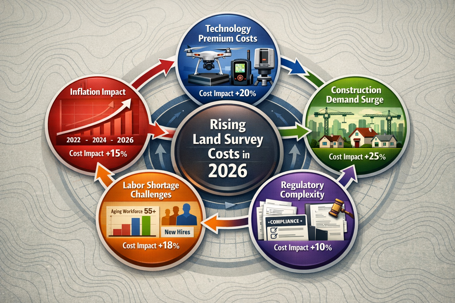
Behind these numbers lies a complex web of economic pressures, technological advancements, and market dynamics that have reshaped the surveying industry. Inflation has pushed equipment and operational costs higher, while the construction boom has created unprecedented demand for surveying services. Meanwhile, advanced technologies like GPS systems and laser scanning have improved accuracy but added premium charges to service bills.
This comprehensive guide breaks down the real factors driving Land Survey Costs in 2026: Factors Driving Increases and How to Budget Smartly, providing property owners with actionable strategies to navigate this expensive but necessary service. From understanding how property characteristics affect pricing to learning negotiation tactics that can save hundreds or even thousands of dollars, readers will gain the knowledge needed to make informed decisions about their surveying needs.
Key Takeaways
📊 National average land survey costs have reached $2,300 in 2026, with a typical range of $800–$5,500, though complex projects can exceed $25,000 for large rural properties.[1][2]
🏗️ Construction demand and inflation are the primary drivers of cost increases, with surveyor hourly rates now averaging $220–$450 and technology investments adding premium charges.[1]
📐 Property size, terrain complexity, and survey type significantly impact final costs, with boundary surveys costing $1,200–$5,500 while comprehensive ALTA surveys range from $2,500–$10,000.[1][2]
💡 Strategic budgeting and negotiation can reduce expenses by 15-30%, including obtaining property records independently, scheduling off-season surveys, and requesting multiple competitive quotes.
🔍 Understanding the specific survey type needed prevents overpaying for unnecessary services while ensuring compliance with lender, legal, or construction requirements.
Understanding the Current Land Survey Cost Landscape in 2026
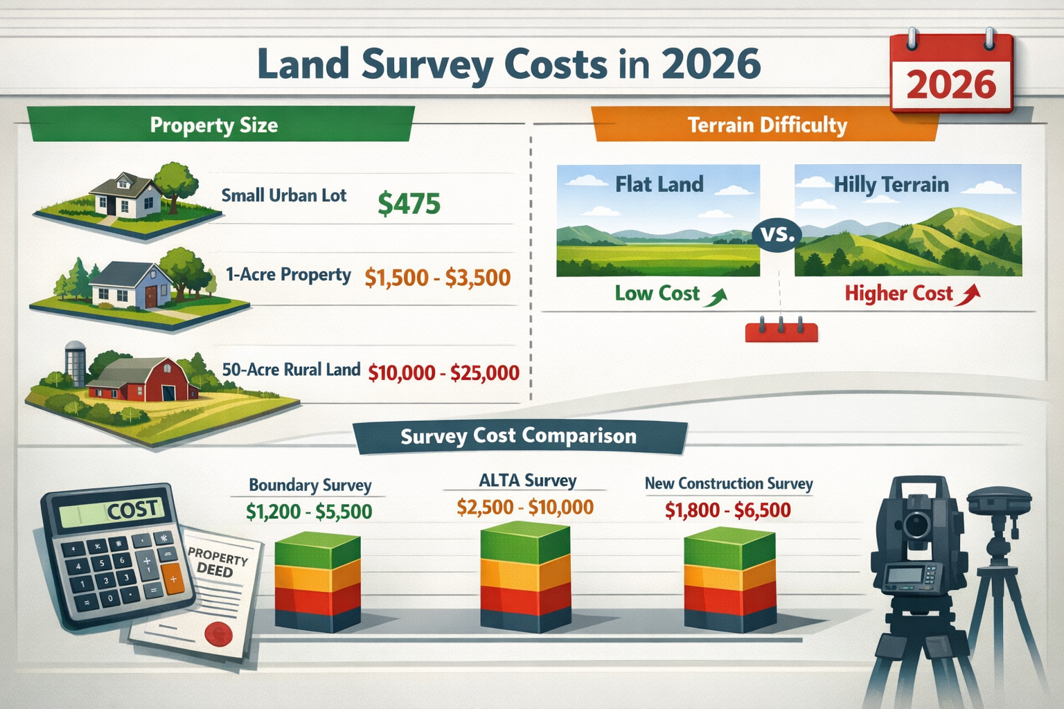
The surveying industry has undergone substantial transformation over the past several years, with 2026 representing a pivotal moment for property owners seeking these essential services. The full spectrum of land survey costs now ranges from $475 for small urban lots to $25,000 for sprawling rural acreage.[1][2] This wide variation reflects the diverse nature of surveying work and the multiple factors that influence pricing.
National Average Costs and Typical Ranges
According to current market data, homeowners can expect to pay approximately $2,300 for a standard land survey in 2026.[1][2] However, this average masks significant variation based on project specifics. The majority of residential property owners will find their costs falling within the $800–$5,500 range, which encompasses most common surveying scenarios.[2]
For those seeking professional surveying services, understanding these baseline figures provides a starting point for budget planning. When engaging with chartered surveyors, property owners should expect detailed quotes that reflect their specific circumstances rather than relying solely on national averages.
Cost Breakdown by Property Size
Property size remains the primary cost driver in land surveying, with a clear relationship between acreage and total expenses.[1] However, this relationship isn't strictly linear—surveyors often apply a "bulk buying" effect where the cost per acre decreases as property size increases.[1]
| Property Size | Typical Cost Range | Cost Per Acre |
|---|---|---|
| Small urban lot (< 0.25 acre) | $475–$900 | $1,900–$3,600 |
| Standard residential (0.5–1 acre) | $1,500–$3,500 | $1,500–$3,500 |
| Medium property (5 acres) | $4,000–$8,000 | $800–$1,600 |
| Large property (10 acres) | $6,500–$12,000 | $650–$1,200 |
| Rural acreage (50 acres) | $10,000–$25,000 | $200–$500 |
This pricing structure reflects the economies of scale in surveying work. While initial setup, research, and equipment deployment carry fixed costs regardless of property size, the marginal cost of surveying additional acres decreases once the surveyor is on-site and familiar with the property's characteristics.
Regional Price Variations Across the United States
Geographic location significantly influences surveying costs, with metropolitan areas averaging $550–$1,100, suburbs $400–$800, and rural areas $350–$650.[2] These variations reflect differences in labor costs, competition levels, and operational expenses across regions.
State-level pricing also shows notable disparities. Texas surveys typically range from $1,100–$4,200, while California properties command $1,200–$5,600 for comparable work.[1] These differences stem from varying regulatory requirements, market demand, and regional cost-of-living factors that affect surveyor overhead and labor rates.
Property owners in high-cost areas may find value in exploring services from chartered surveyors in different regions to understand competitive pricing, though local knowledge and licensing requirements often necessitate working with nearby professionals.
Key Factors Driving Land Survey Cost Increases in 2026
Understanding Land Survey Costs in 2026: Factors Driving Increases and How to Budget Smartly requires examining the economic and industry-specific pressures reshaping the surveying marketplace. Multiple converging trends have pushed costs upward, creating challenges for property owners while simultaneously improving service quality and accuracy.
Inflation Impact on Equipment and Operations
The broader inflationary environment has significantly affected surveying businesses. Equipment costs have risen substantially, with modern total stations, GPS receivers, and laser scanning devices representing major capital investments that surveyors must recoup through service fees. Additionally, vehicle costs, fuel expenses, and general operational overhead have all increased in line with broader economic trends.
Insurance premiums for professional liability coverage have also climbed, reflecting the critical nature of accurate surveying work and the potential consequences of errors. These fixed costs must be distributed across all projects, contributing to higher baseline pricing across the industry.
Technology Premium: Advanced Tools and Software
Modern surveying has become increasingly sophisticated, with technology investments adding premium charges to traditional services.[8] While these advancements improve accuracy and efficiency, they come with substantial costs:
- GPS and GNSS systems providing centimeter-level accuracy require significant initial investment and ongoing subscription fees for correction services
- Drone technology enables efficient large-area mapping but demands specialized equipment, licensing, and trained operators
- Laser scanning and LiDAR systems capture incredibly detailed data but represent six-figure investments for surveying firms
- Advanced software platforms for data processing, CAD work, and 3D modeling require expensive licenses and continuous updates
These technological improvements benefit clients through more accurate results and faster turnaround times, but the costs are inevitably reflected in service pricing. The surveying market has seen a compound annual growth rate driven partly by these technological investments.[8]
Construction Boom and Demand Surge
The construction industry's robust activity in 2026 has created unprecedented demand for surveying services. With residential development, commercial projects, and infrastructure improvements all requiring surveys at various stages, surveying firms face capacity constraints that naturally drive prices higher.
This demand surge has several effects on pricing:
- Reduced availability leads to longer wait times and premium pricing for expedited services
- Competitive bidding becomes less common as surveyors can maintain full schedules at higher rates
- Seasonal fluctuations become more pronounced, with peak construction seasons commanding premium prices
Real estate market dynamics also play a role. According to industry forecasts, housing market activity continues to generate substantial surveying demand, particularly for boundary surveys required in property transactions.[7]
Labor Shortage and Skilled Surveyor Scarcity
The surveying profession faces a significant labor shortage that directly impacts pricing. Several factors contribute to this challenge:
- Aging workforce with many experienced surveyors approaching retirement
- Limited pipeline of new professionals entering the field
- Lengthy licensing requirements that delay workforce expansion
- Competition from other technical fields for talented candidates
This scarcity has pushed hourly labor rates to average $220–$450 per hour for surveying crews, depending on crew size and project scope.[1] Larger projects requiring multiple surveyors naturally incur higher total costs, while even simple surveys reflect these elevated labor rates.
Regulatory Complexity and Compliance Costs
Increasingly complex regulatory requirements add hidden costs to surveying work. Research time for property records has become more expensive, with straightforward surveys maintaining baseline rates while research-intensive projects with missing or outdated records can increase costs by up to $1,000.[2] Research services typically bill at $85–$160 per hour.[1]
Compliance with state-specific regulations, continuing education requirements for licensed surveyors, and adherence to professional standards all contribute to operational costs that ultimately affect client pricing. Properties with complex ownership histories or unclear boundaries require extensive title research and historical document review, adding substantial time and expense to projects.
Types of Land Surveys and Their Associated Costs
Not all surveys are created equal, and understanding Land Survey Costs in 2026: Factors Driving Increases and How to Budget Smartly requires recognizing the distinct purposes and pricing of different survey types. Selecting the appropriate survey for specific needs prevents both overpaying for unnecessary detail and underinvesting in critical information.
Boundary Surveys: The Most Common Type
Boundary surveys cost $1,200–$5,500 and represent the most frequently requested surveying service.[1][2] These surveys establish or verify property lines, locate corners and markers, and identify any encroachments or easements affecting the property.
Boundary surveys serve multiple purposes:
- ✅ Resolving property line disputes with neighbors
- ✅ Installing fences along accurate property boundaries
- ✅ Supporting real estate transactions
- ✅ Identifying encroachments before they become legal issues
- ✅ Providing documentation for property improvements
The cost variation within this category reflects property size, terrain complexity, and the availability of existing survey records. Properties with well-documented boundaries and recent surveys typically fall toward the lower end of the range, while those requiring extensive research and fieldwork command higher fees.
For comprehensive property assessments, many buyers combine boundary surveys with other services like a homebuyer survey to gain complete understanding of their investment.
ALTA/NSPS Land Title Surveys
ALTA surveys cost $2,500–$10,000 and represent the most comprehensive surveying option available.[1] Developed jointly by the American Land Title Association and National Society of Professional Surveyors, these surveys meet stringent standards required by title insurance companies and commercial lenders.
ALTA surveys include extensive detail:
- Complete boundary identification and monumentation
- Location of all improvements, utilities, and access points
- Identification of all easements, rights-of-way, and encumbrances
- Verification of zoning compliance
- Detailed written description of findings
- Certification to title companies and lenders
Commercial property transactions almost universally require ALTA surveys, making them a necessary expense despite the premium pricing. The comprehensive nature of these surveys provides maximum legal protection and typically satisfies all stakeholder requirements in complex transactions.
New Construction Surveys
New construction surveys range $1,800–$6,500 due to the multiple survey types they require.[1] Construction projects typically need surveys at several stages:
- Pre-construction boundary survey to establish property lines
- Site plan/plot plan showing proposed improvements relative to boundaries
- Foundation survey verifying correct placement before proceeding
- As-built survey documenting final construction locations
This multi-stage approach ensures compliance with setback requirements, prevents encroachments, and provides documentation for future reference. While the cumulative cost may seem substantial, these surveys prevent far more expensive problems that could arise from improperly positioned structures.
Developers and builders often work with commercial property surveying specialists who understand the unique requirements of construction projects and can coordinate multiple survey phases efficiently.
Topographic and Mortgage Surveys
Topographic surveys document elevation changes, contours, and natural features, typically costing $1,500–$4,500 depending on property size and terrain complexity. These surveys are essential for:
- Engineering and architectural design
- Drainage planning
- Grading and excavation projects
- Environmental assessments
Mortgage surveys represent a simpler option, often costing $300–$600, that shows basic property boundaries and major improvements. However, many lenders now require more comprehensive surveys, making this economy option less common than in previous years.
Specialized Survey Types
Several specialized surveys address specific needs:
- Subdivision surveys ($3,000–$10,000+) divide larger parcels into multiple lots
- Elevation certificates ($500–$2,000) document flood risk for insurance purposes
- Utility surveys ($800–$3,000) locate underground and overhead utilities
- Hydrographic surveys ($2,500–$8,000+) map underwater features for waterfront properties
Each specialized survey type requires particular expertise and equipment, justifying premium pricing for these niche services.
Property Characteristics That Affect Survey Costs
Beyond survey type, specific property characteristics significantly influence final costs. Understanding these factors helps property owners anticipate expenses and explains why Land Survey Costs in 2026: Factors Driving Increases and How to Budget Smartly varies so dramatically between seemingly similar properties.
Terrain Complexity and Accessibility
Terrain complexity adds substantial costs to surveying work. Flat, easily accessible land on 1-acre lots typically costs $1,500–$3,500, while hilly or rough terrain increases costs by $1,000–$2,000, reaching $2,500–$5,500 for the same acreage.[2]
Challenging terrain creates multiple cost factors:
- Difficult access requires more time to transport equipment
- Steep slopes slow fieldwork and increase safety requirements
- Dense vegetation necessitates clearing sight lines for accurate measurements
- Rocky or unstable ground complicates monument placement
- Wetlands or water features require specialized techniques and equipment
Properties with significant elevation changes may also benefit from structural engineering assessments to address foundation and drainage considerations revealed by topographic surveys.
Lot Shape and Boundary Complexity
Lot shape impacts expenses significantly. Rectangular lots cost approximately $380–$750, while irregular eight-sided lots cost $580–$950.[2] Surveyors typically charge roughly $50 more per additional side beyond rectangular.[2]
This pricing structure reflects the additional work required for complex boundaries:
- More corners require more monuments to locate or set
- Irregular shapes demand more measurements to verify accuracy
- Complex boundaries increase calculation and documentation time
- Unusual configurations may indicate historical boundary adjustments requiring research
Properties with curved boundaries, multiple angles, or irregular configurations should expect costs toward the higher end of quoted ranges.
Existing Survey Records and Documentation
The availability and quality of existing survey records dramatically affect costs. Properties with recent, accurate surveys and clear title histories require minimal research and can often be resurveyed more efficiently, reducing costs.
Conversely, properties with missing or outdated records can increase costs by up to $1,000 for additional research.[2] Challenges include:
- 🔍 Conflicting historical surveys requiring reconciliation
- 🔍 Missing monuments necessitating extensive search efforts
- 🔍 Unclear legal descriptions demanding title research
- 🔍 Disputed boundaries requiring additional documentation
- 🔍 Historical ownership changes with incomplete records
Property owners can reduce these costs by gathering available documentation before engaging surveyors, including previous surveys, title policies, and deed descriptions.
Urban vs. Rural Property Considerations
Location type affects both direct costs and practical considerations. Metropolitan areas average $550–$1,100, suburbs $400–$800, and rural areas $350–$650.[2]
However, these figures can be misleading. Urban properties often involve:
- ✅ Better access to existing records and monuments
- ✅ Smaller lot sizes reducing fieldwork time
- ✅ Higher surveyor availability and competition
- ❌ Higher labor costs and operational overhead
- ❌ Complex easements and utility networks
- ❌ Restricted access and parking challenges
Rural properties present different trade-offs:
- ✅ Lower hourly rates in less expensive markets
- ✅ Simpler utility and easement situations
- ❌ Larger areas requiring more fieldwork
- ❌ Greater travel distances for surveyors
- ❌ Potentially outdated or missing records
- ❌ Difficult terrain and access challenges
Understanding these urban-rural dynamics helps property owners set realistic budget expectations based on their specific location.
Time-Sensitive and Rush Projects
Standard surveying timelines typically range from 2–4 weeks from engagement to final deliverables. However, rush services commanding premium fees have become increasingly common in 2026's competitive market.
Expedited surveys may add:
- 25–50% premium for 1-week turnaround
- 50–100% premium for 2–3 day rush service
- Custom pricing for same-day or next-day emergency surveys
Property owners should plan ahead whenever possible to avoid these premium charges. Real estate transactions, construction schedules, and legal deadlines should account for standard surveying timelines to prevent unnecessary rush fees.
Smart Budgeting Strategies for Land Survey Costs in 2026
Successfully managing Land Survey Costs in 2026: Factors Driving Increases and How to Budget Smartly requires strategic planning and informed decision-making. Property owners who approach surveying as an investment rather than an expense often find opportunities to reduce costs while maintaining quality.
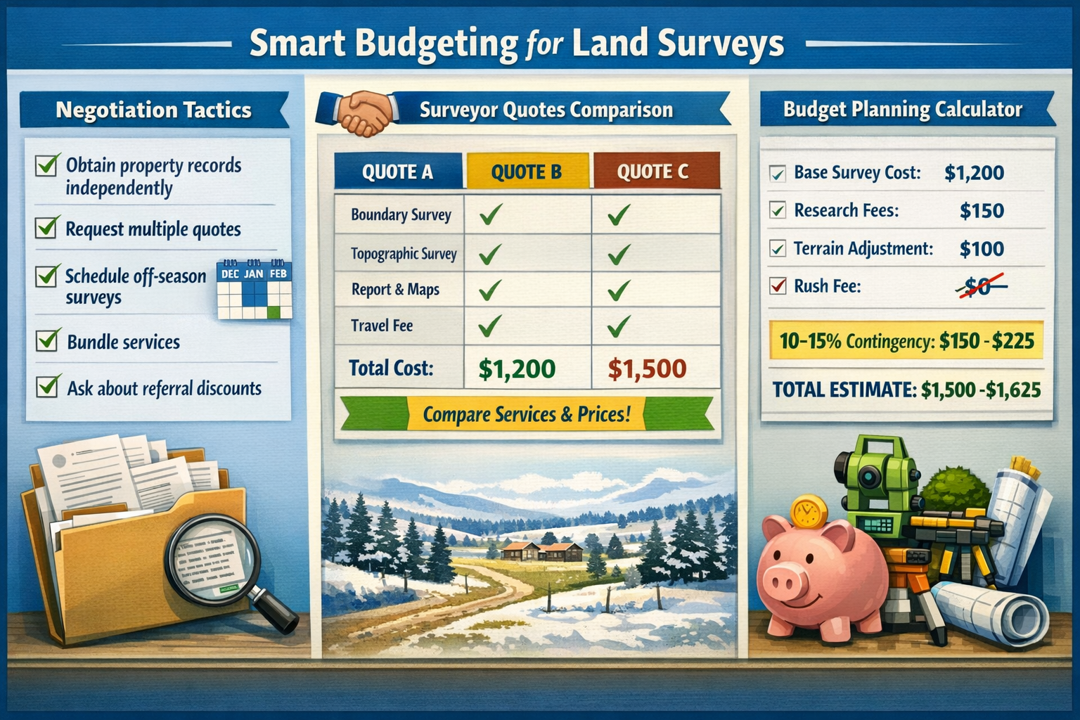
Obtaining Multiple Competitive Quotes
Requesting quotes from 3–5 surveyors provides valuable market intelligence and negotiating leverage. When soliciting quotes, property owners should:
- Provide identical information to all surveyors for accurate comparison
- Request detailed breakdowns of costs rather than single totals
- Ask about included services and potential additional charges
- Verify licensing, insurance, and professional credentials
- Check references and review previous work quality
Price shouldn't be the only consideration—experience with similar properties, turnaround time, and professional reputation all factor into value. However, competitive bidding often reveals pricing variations of 20–40% between surveyors for identical work, making comparison shopping worthwhile.
Working with established firms like RICS chartered surveyors provides assurance of professional standards while still allowing for competitive pricing.
Reducing Research Costs Through Self-Service
Obtaining property records directly from county offices rather than having surveyors research them can reduce charges significantly. Property owners can typically access:
- Previous survey plats and documents
- Deed descriptions and title information
- Easement records and restrictions
- Tax maps and parcel information
- Historical ownership records
County recorder offices, assessor websites, and title companies often provide these documents for minimal fees ($10–$50) compared to surveyor research rates of $85–$160 per hour.[1] Gathering this information before engaging a surveyor demonstrates preparation and may qualify for reduced rates.
However, property owners should recognize that professional surveyors bring expertise in interpreting these documents that laypersons may lack. The goal is reducing redundant research time, not replacing professional analysis.
Timing Surveys for Off-Season Savings
Seasonal demand fluctuations create opportunities for cost savings. Surveying activity typically peaks during:
- Spring and summer construction seasons
- Fall real estate transaction periods
- Times of favorable weather and longer daylight hours
Conversely, winter months often see reduced demand, particularly in regions with harsh weather. Surveyors may offer:
- 10–20% discounts during slow periods
- More flexible scheduling and faster turnaround
- Greater availability of senior staff for complex projects
- Willingness to negotiate on pricing
Property owners with flexible timelines should inquire about off-season rates and availability. Even in regions with mild winters, demand patterns often create pricing opportunities during traditionally slow months.
Bundling Services for Volume Discounts
Property owners requiring multiple services or surveys should explore bundling opportunities. Scenarios where bundling makes sense include:
- Purchasing properties requiring both boundary and topographic surveys
- Construction projects needing multiple survey phases
- Commercial transactions requiring ALTA surveys plus specialized assessments
- Multiple properties surveyed by the same firm
Surveyors often provide 10–25% discounts for bundled services since they can achieve efficiencies through:
- Single mobilization for multiple tasks
- Shared research and documentation efforts
- Relationship building for ongoing work
- Reduced administrative overhead
Property owners should clearly communicate all anticipated surveying needs upfront to maximize bundling opportunities.
Leveraging Referrals and Professional Relationships
Referrals from realtors, contractors, or attorneys may yield discounts as surveyors value these ongoing professional relationships.[1] Additionally:
- Real estate professionals often have negotiated rates with preferred surveyors
- Contractors may receive volume discounts they can pass through
- Attorneys may have relationships with surveyors who understand specific legal requirements
- Previous clients may receive loyalty discounts for repeat business
Property owners should ask their professional advisors about surveying recommendations and potential cost advantages. However, they should also verify that referred surveyors meet their specific needs and maintain competitive pricing.
Creating Realistic Budget Contingencies
Even with careful planning, survey costs can exceed initial estimates due to unforeseen complications. Smart budgeting includes:
- 15–20% contingency above quoted prices for standard surveys
- 25–30% contingency for properties with complex histories or terrain
- Separate line items for potential research, monument replacement, or additional fieldwork
- Written agreements specifying conditions under which additional charges apply
Understanding what might trigger additional costs helps property owners avoid unpleasant surprises. Common additional charges include:
- 💰 Extensive research for properties with unclear boundaries
- 💰 Monument replacement when existing markers are missing or damaged
- 💰 Vegetation clearing to establish sight lines
- 💰 Additional fieldwork when initial surveys reveal discrepancies
- 💰 Expedited processing for time-sensitive needs
By anticipating these possibilities and budgeting accordingly, property owners maintain financial control throughout the surveying process.
Understanding What's Included vs. Additional Costs
Clarifying scope before engagement prevents misunderstandings about deliverables and costs. Standard survey packages typically include:
✅ Fieldwork and measurements
✅ Research of readily available records
✅ Basic plat or map showing findings
✅ Written description of boundaries
✅ Professional certification
Additional costs may apply for:
❌ Multiple copies of survey documents
❌ Digital CAD files or specialized formats
❌ Staking or monumenting boundaries
❌ Extensive title research
❌ Testimony or expert witness services
❌ Revisions based on changed requirements
Property owners should request detailed proposals specifying exactly what's included and what might incur additional charges. This transparency enables accurate budgeting and prevents scope creep.
Negotiating Land Survey Costs: Practical Tips
Beyond strategic budgeting, effective negotiation can reduce survey costs by 10–25% without compromising quality. Understanding Land Survey Costs in 2026: Factors Driving Increases and How to Budget Smartly includes developing negotiation skills specific to surveying services.
Understanding Surveyor Cost Structures
Successful negotiation begins with understanding how surveyors price their services. Most surveying costs break down into:
- Fixed costs (research, office work, equipment depreciation) – typically 30–40% of total
- Variable costs (fieldwork time, crew size, travel) – typically 40–50% of total
- Profit margin (business sustainability, risk management) – typically 15–25% of total
This structure reveals negotiation opportunities. While profit margins have some flexibility, attempting to negotiate below a surveyor's cost structure produces poor results. Instead, focus on:
- Reducing variable costs through timing, access, or preparation
- Minimizing fixed costs through self-service research
- Demonstrating value as a client (referrals, repeat business, straightforward project)
Questions to Ask Before Committing
Informed clients negotiate more effectively. Before committing to a surveyor, ask:
- "What specific deliverables are included in this quote?"
- "What circumstances might trigger additional charges?"
- "Do you offer discounts for off-season scheduling?"
- "What information can I provide to reduce research time?"
- "Are there package rates if I need multiple services?"
- "What's your timeline, and is there flexibility on urgency?"
- "Do you offer payment plans or milestone billing?"
These questions demonstrate sophistication and create opportunities for cost reduction while clarifying expectations.
Avoiding Common Pitfalls
Several mistakes can increase survey costs unnecessarily:
❌ Selecting the wrong survey type – paying for comprehensive ALTA surveys when simple boundary surveys suffice
❌ Poor communication – failing to disclose property complexities that surveyors discover mid-project
❌ Unrealistic timelines – creating artificial urgency that triggers rush fees
❌ Incomplete information – forcing surveyors to conduct research you could have provided
❌ Choosing solely on price – selecting unqualified surveyors who produce inadequate work requiring re-surveying
The cheapest survey isn't always the best value. Inadequate surveys can lead to legal disputes, construction errors, or title problems that cost far more than the initial savings.
When Premium Services Justify Higher Costs
Some situations warrant paying premium prices for superior service:
- Complex commercial transactions where ALTA survey detail prevents future disputes
- Properties with known boundary disputes requiring expert testimony capability
- Time-critical situations where delays cost more than rush fees
- High-value properties where accuracy justifies premium investment
- Projects requiring specialized expertise like commercial building surveys
Understanding when to invest in premium services versus when to economize represents sophisticated budgeting rather than penny-wise, pound-foolish decision-making.
Regional Considerations for Land Survey Costs
Land Survey Costs in 2026: Factors Driving Increases and How to Budget Smartly varies significantly by region, with local market conditions, regulatory requirements, and geographic characteristics all influencing pricing.
High-Cost Metropolitan Markets
Major metropolitan areas typically command premium surveying rates due to:
- Higher operational costs including office space, insurance, and labor
- Complex regulatory environments requiring additional expertise
- Dense development creating challenging survey conditions
- Higher demand reducing competitive pricing pressure
Cities like San Francisco, New York, Boston, and Los Angeles often see survey costs 30–50% above national averages. However, these markets also offer:
- Greater surveyor availability and specialization
- Advanced technology adoption
- Faster turnaround times due to better infrastructure
- More competitive bidding opportunities
Property owners in high-cost markets should focus on value rather than absolute price, ensuring they receive appropriate expertise for their specific urban challenges.
Rural and Agricultural Property Surveys
Rural properties present unique pricing dynamics. While base hourly rates may be lower, total costs often increase due to:
- Larger property sizes requiring extensive fieldwork
- Greater travel distances and mobilization time
- Limited surveyor availability in remote areas
- Outdated or missing records requiring research
- Challenging terrain and access issues
Agricultural land surveys often benefit from the "bulk buying" effect on per-acre costs, but absolute expenses can still be substantial. A 50-acre rural property costing $10,000–$25,000 for surveying represents significant investment despite relatively low per-acre rates.[1]
State-Specific Variations and Requirements
State-level regulatory differences create pricing variations beyond simple cost-of-living adjustments:
| State | Typical Range | Key Factors |
|---|---|---|
| Texas | $1,100–$4,200 | Large properties, complex title history, specific state requirements |
| California | $1,200–$5,600 | High costs, strict regulations, earthquake considerations |
| Florida | $900–$3,800 | Elevation certificates, flood zones, wetland issues |
| New York | $1,300–$5,200 | Complex title systems, high labor costs, dense development |
Some states require specific survey formats, additional certifications, or particular professional credentials that affect costs. Property owners should work with locally licensed surveyors familiar with state-specific requirements.
For properties in specific regions, consulting with local specialists like chartered surveyors in Hertfordshire or chartered surveyors in Sussex ensures compliance with regional standards.
Technology's Role in Modern Survey Costs
The surveying profession has undergone dramatic technological transformation, with implications for both service quality and Land Survey Costs in 2026: Factors Driving Increases and How to Budget Smartly.
GPS and GNSS Systems
Modern GPS and Global Navigation Satellite Systems provide centimeter-level accuracy, revolutionizing surveying precision. However, this technology comes at a cost:
- High-end GPS receivers cost $15,000–$50,000 per unit
- Subscription services for real-time corrections add $1,500–$3,000 annually
- Regular calibration and maintenance require ongoing investment
- Specialized training for operators increases labor costs
Despite these expenses, GPS technology often reduces total survey costs by dramatically accelerating fieldwork. What once required days of traditional surveying can now be accomplished in hours, potentially offsetting equipment costs through efficiency gains.
Drone and Aerial Survey Technology
Unmanned aerial vehicles (UAVs) have become increasingly common in surveying applications, particularly for:
- Large property topographic mapping
- Difficult-to-access terrain
- Construction progress monitoring
- Volumetric calculations for earthwork
Drone surveys offer advantages including:
- ✈️ Rapid data collection over large areas
- ✈️ Safe access to dangerous or difficult terrain
- ✈️ Highly detailed aerial imagery and 3D models
- ✈️ Cost-effective coverage of extensive properties
However, drone technology adds costs through equipment investment ($5,000–$25,000 for professional systems), licensing requirements, insurance, and specialized operator training. These costs are typically passed through to clients as premium charges for drone-enabled surveys.
Laser Scanning and 3D Modeling
Terrestrial laser scanning (LiDAR) captures millions of data points to create incredibly detailed 3D models of properties and structures. This technology excels for:
- As-built documentation of complex buildings
- Historic preservation projects
- Industrial facility surveys
- Detailed topographic mapping
Laser scanning systems represent substantial investment ($50,000–$150,000+), justifying premium pricing for projects requiring this capability. However, the resulting data provides unprecedented detail and accuracy that traditional methods cannot match.
Software and Data Processing Costs
Modern surveying relies on sophisticated software for:
- CAD drafting and plan production
- Data processing and adjustment calculations
- 3D modeling and visualization
- Geographic Information Systems (GIS) integration
Professional-grade software licenses cost $5,000–$15,000 annually per seat, with additional costs for specialized applications. These overhead expenses contribute to the overall cost structure that clients ultimately pay.
Legal and Regulatory Considerations Affecting Costs
Regulatory compliance and legal requirements significantly influence Land Survey Costs in 2026: Factors Driving Increases and How to Budget Smartly, with various mandates adding complexity and expense to surveying work.
Professional Licensing and Certification Requirements
All states require professional land surveyors to hold valid licenses, obtained through:
- Four-year degree in surveying or related field (or equivalent experience)
- Passing the Fundamentals of Surveying (FS) exam
- Supervised work experience (typically 4 years)
- Passing the Principles and Practice of Surveying (PS) exam
- Continuing education to maintain licensure
These rigorous requirements ensure competence but also create barriers to entry that limit surveyor supply and support higher pricing. Additionally, surveyors must maintain:
- Professional liability insurance ($1M–$2M typical coverage)
- Errors and omissions insurance
- General business liability coverage
- Workers' compensation for employees
Insurance costs alone can represent 5–10% of a surveying firm's revenue, expenses that must be recovered through client fees.
Title Insurance and Lender Requirements
Title insurance companies and mortgage lenders often mandate specific survey types and formats, limiting property owners' ability to economize. Common requirements include:
- ALTA surveys for commercial transactions
- Boundary surveys meeting specific title company standards
- Certification to particular parties (lender, title company, buyer)
- Specific detail levels regarding improvements and encumbrances
These requirements prevent property owners from selecting minimal survey options, ensuring comprehensive documentation but increasing costs. However, they also provide valuable protection against future disputes and title defects.
Zoning and Building Code Compliance
Surveys often must verify compliance with:
- Setback requirements from property lines
- Height restrictions and bulk regulations
- Parking and access requirements
- Easement and right-of-way restrictions
- Floodplain and environmental regulations
Verifying zoning compliance adds research and analysis time to surveys, particularly in jurisdictions with complex or frequently changing regulations. Properties in multiple zoning districts or subject to special restrictions require additional work that increases costs.
Boundary Dispute and Legal Testimony Costs
When surveys reveal boundary disputes or are needed for legal proceedings, costs escalate significantly. Expert witness services for surveyors typically bill at:
- $250–$500 per hour for deposition testimony
- $350–$650 per hour for trial testimony
- Additional charges for report preparation and case review
Property owners facing boundary disputes should budget substantially more than standard survey costs, potentially $5,000–$20,000+ for comprehensive expert services. Preventing disputes through proactive surveying represents far better value than resolving them after conflicts arise.
For properties with potential boundary issues, services like boundary surveys provide documentation that can prevent costly future disputes.
Future Outlook: Survey Costs Beyond 2026
Understanding current trends helps property owners anticipate Land Survey Costs in 2026: Factors Driving Increases and How to Budget Smartly while planning for future needs.
Projected Market Trends
The land surveying market shows continued growth driven by several factors:
- Sustained construction activity maintaining strong demand for surveying services[8]
- Infrastructure investment creating opportunities for large-scale surveying projects
- Technology adoption requiring ongoing capital investment that influences pricing
- Regulatory complexity increasing compliance costs across the industry
Industry analysts project continued modest cost increases of 3–5% annually beyond 2026, roughly tracking inflation plus technology premiums.[8] However, regional variations and specific market conditions may produce different trajectories in particular areas.
Technology Developments That May Reduce Costs
Several emerging technologies could eventually reduce surveying costs:
- Automated data processing using artificial intelligence to reduce manual labor
- Improved GPS accuracy from new satellite constellations and correction services
- Lower-cost drone technology making aerial surveys more accessible
- Cloud-based software reducing licensing costs through subscription models
- Mobile device integration enabling some simple surveys through smartphone technology
However, these technologies require substantial initial investment and professional expertise to implement effectively. Cost reductions may take years to materialize as the industry gradually adopts new approaches.
Workforce Development and Supply Dynamics
The surveying profession's labor shortage represents the most significant challenge to cost stabilization. Addressing this requires:
- Educational pipeline expansion through university programs and technical schools
- Apprenticeship programs connecting new professionals with experienced mentors
- Technology tools that enhance productivity of existing workforce
- Immigration policies that allow qualified international surveyors to practice
- Competitive compensation that attracts talent from other technical fields
Without workforce expansion, labor costs will likely continue rising faster than general inflation, putting upward pressure on survey pricing. Property owners should anticipate this dynamic when planning long-term projects requiring surveying services.
Sustainability and Environmental Considerations
Environmental regulations and sustainability initiatives increasingly affect surveying work:
- Wetland delineation and environmental impact assessments
- Green building certification requirements
- Climate change adaptation planning
- Renewable energy project siting
- Conservation easement documentation
These specialized services require additional expertise and often command premium pricing. As environmental considerations become more central to development and property management, surveying costs may increase to reflect this expanded scope.
Case Studies: Real-World Survey Cost Examples
Examining specific scenarios illustrates how various factors combine to determine Land Survey Costs in 2026: Factors Driving Increases and How to Budget Smartly in practice.
Case Study 1: Suburban Residential Boundary Survey
Property: 0.75-acre suburban lot, rectangular shape, flat terrain
Location: Mid-sized city, moderate cost-of-living area
Survey Type: Boundary survey for fence installation
Existing Records: Survey from 15 years ago, clear title
Cost Breakdown:
- Base survey fee: $1,200
- Research (minimal due to recent survey): $150
- Fieldwork (straightforward): $800
- Plat preparation and certification: $350
- Total Cost: $2,500
This example represents a straightforward scenario near the lower end of typical costs. The property's characteristics (small size, simple shape, flat terrain, good records) minimized expenses while still providing necessary boundary documentation.
Case Study 2: Rural Acreage ALTA Survey
Property: 25-acre rural parcel, irregular shape, rolling terrain
Location: Rural area, 45 minutes from nearest city
Survey Type: ALTA survey for commercial development financing
Existing Records: Outdated survey from 1970s, some missing monuments
Cost Breakdown:
- Base ALTA survey fee: $4,500
- Extensive research (old records): $1,200
- Additional fieldwork (size and terrain): $3,800
- Monument replacement: $650
- Travel time and mobilization: $800
- Comprehensive ALTA documentation: $1,500
- Total Cost: $12,450
This complex project illustrates how multiple cost factors compound. The ALTA survey requirement, property size, challenging records, and rural location all contributed to substantially higher costs than a simple boundary survey would have incurred.
Case Study 3: Urban Lot with Boundary Dispute
Property: 0.25-acre urban lot, irregular shape, flat terrain
Location: Major metropolitan area
Survey Type: Boundary survey with expert opinion on disputed line
Existing Records: Conflicting surveys from neighbors
Cost Breakdown:
- Base survey fee: $1,800
- Extensive title and survey research: $2,400
- Detailed fieldwork and analysis: $1,500
- Expert report preparation: $1,800
- Initial consultation for potential testimony: $750
- Total Cost: $8,250
Despite the small property size, the boundary dispute and conflicting records created substantial costs. This example demonstrates how legal complications can make even simple properties expensive to survey properly.
Maximizing Value from Your Land Survey Investment
Beyond minimizing costs, property owners should focus on maximizing the value received from surveying investments, ensuring Land Survey Costs in 2026: Factors Driving Increases and How to Budget Smartly delivers lasting benefits.
Ensuring Comprehensive Deliverables
Standard survey deliverables should include:
📋 Physical or digital plat showing property boundaries and improvements
📋 Written legal description of surveyed boundaries
📋 Professional certification to relevant parties
📋 Explanation of findings including any issues discovered
📋 Monument locations with descriptions for future reference
Property owners should verify they receive all agreed-upon deliverables in usable formats. Digital files in common formats (PDF, CAD) provide flexibility for future use, while multiple copies ensure availability when needed.
Proper Documentation and Record Keeping
Maintaining survey records provides value long after the initial investment:
- Store original surveys in safe, accessible locations
- Provide copies to title companies and include in property files
- Share relevant information with contractors, architects, or engineers
- Update surveys when property changes occur
- Include surveys in property sale documentation
Well-maintained survey records prevent the need for expensive re-surveys and provide valuable documentation for future property owners.
Leveraging Survey Information for Property Planning
Beyond immediate needs, surveys provide valuable information for:
- Future improvements – understanding setbacks and buildable areas
- Landscaping projects – respecting boundaries and easements
- Property value assessment – accurate lot size and usable area
- Dispute prevention – clear documentation of boundaries
- Insurance and tax purposes – accurate property descriptions
Property owners who view surveys as long-term planning tools rather than one-time expenses extract greater value from their investment.
When to Update or Resurvey
Certain circumstances warrant new surveys despite existing documentation:
- ⏰ Surveys older than 10–15 years may not reflect current conditions
- ⏰ Significant property improvements or modifications
- ⏰ Boundary disputes or encroachment concerns
- ⏰ Property subdivision or consolidation
- ⏰ Lender or title company requirements for current surveys
- ⏰ Changes in adjacent properties affecting boundaries
While resurveying represents additional expense, outdated surveys can create problems that cost far more than preventive updates.
For comprehensive property assessments, combining land surveys with other professional evaluations like RICS building surveys provides complete property understanding.
Conclusion: Taking Action on Land Survey Costs
Understanding Land Survey Costs in 2026: Factors Driving Increases and How to Budget Smartly empowers property owners to make informed decisions about this essential but expensive service. While costs have undeniably increased due to inflation, technology investments, construction demand, and labor shortages, strategic approaches can minimize expenses while ensuring quality results.
Key Action Steps for Property Owners
Property owners facing surveying needs should:
- Determine the appropriate survey type for their specific needs, avoiding both over- and under-investment in surveying services
- Request multiple competitive quotes from licensed, insured professionals to establish fair market pricing
- Gather existing property documentation to reduce research time and associated costs
- Consider timing flexibility to take advantage of off-season rates and better availability
- Communicate clearly with surveyors about requirements, timelines, and budget constraints
- Budget conservatively with 15–30% contingency for unexpected complications
- Verify deliverables and scope before committing to prevent misunderstandings
- Maintain survey records for future reference and to prevent unnecessary re-surveying
The Value Proposition of Professional Surveying
Despite the significant costs involved, professional land surveys provide essential value that justifies the investment:
- ✅ Legal protection through accurate boundary documentation
- ✅ Dispute prevention by clearly establishing property lines before conflicts arise
- ✅ Transaction facilitation by meeting lender and title company requirements
- ✅ Construction accuracy ensuring improvements are properly positioned
- ✅ Property value through accurate lot size and usable area documentation
- ✅ Peace of mind from knowing exactly what you own
The cost of inadequate or missing surveys—including legal disputes, construction errors, title problems, and transaction delays—far exceeds the expense of proper surveying work.
Looking Forward
As 2026 progresses and the surveying industry continues evolving, property owners who understand cost drivers and budgeting strategies will navigate this necessary expense most successfully. While costs are unlikely to decrease significantly in the near term, informed consumers can find quality services at fair prices through research, comparison, and strategic planning.
The investment in professional surveying represents not just a transaction cost but a foundation for confident property ownership, development, and use. By approaching Land Survey Costs in 2026: Factors Driving Increases and How to Budget Smartly with knowledge and strategy, property owners transform a potentially frustrating expense into a valuable asset that serves their needs for years to come.
Next Steps
For property owners ready to proceed with surveying services:
- Contact 3–5 licensed surveyors in your area for detailed quotes
- Gather existing property documentation including deeds, previous surveys, and title policies
- Clarify your specific needs and timeline to ensure appropriate survey type selection
- Review proposals carefully comparing scope, deliverables, and pricing
- Ask questions about anything unclear before committing
- Plan for contingencies in your budget to accommodate potential complications
Taking these steps positions property owners for successful surveying experiences that meet their needs while managing costs effectively. Whether purchasing property, resolving boundaries, or planning improvements, professional surveying provides the foundation for confident decision-making and successful outcomes.
For additional guidance on property surveys and related services, explore resources on comparing different types of surveys and RICS home surveys to understand the full range of options available.
References
[1] How Much Does Land Survey Cost – https://www.angi.com/articles/how-much-does-land-survey-cost.htm
[2] Land Survey Cost – https://todayshomeowner.com/lawn-garden/cost/land-survey-cost/
[3] How Much Does A Land Survey Cost 2 – https://goldenstatede.com/how-much-does-a-land-survey-cost-2/
[4] Land Survey Cost – https://www.mysiteplan.com/blogs/news/land-survey-cost
[5] Boundary Survey Cost Price – https://haller-blanchard.com/boundary-survey-cost-price/
[6] How Much Is A Property Survey – https://www.benzinga.com/money/how-much-is-a-property-survey
[7] 2026 Real Estate Outlook What Leading Housing Economists Are Watching – https://www.nar.realtor/magazine/real-estate-news/2026-real-estate-outlook-what-leading-housing-economists-are-watching
[8] Land Surveying Market Report – https://www.cognitivemarketresearch.com/land-surveying-market-report