}
The property surveying industry is experiencing a revolutionary transformation in 2026, driven by autonomous drones that can self-adjust for optimal readings across vast properties. What once required weeks of manual labor and significant financial investment can now be accomplished in mere hours with unprecedented accuracy. Autonomous Drones in Property Surveying: From Flight Planning to Multi-Sensor Data Capture represents the cutting edge of this technological evolution, fundamentally reshaping how professionals assess, document, and analyze real estate assets.
The real estate drone services market has surged from $0.57 billion in 2025 to $0.67 billion in 2026, reflecting the accelerating adoption of autonomous drone technology across the surveying sector[7]. This growth isn't merely about replacing traditional methods—it's about unlocking capabilities that were previously impossible or economically unfeasible.
Key Takeaways
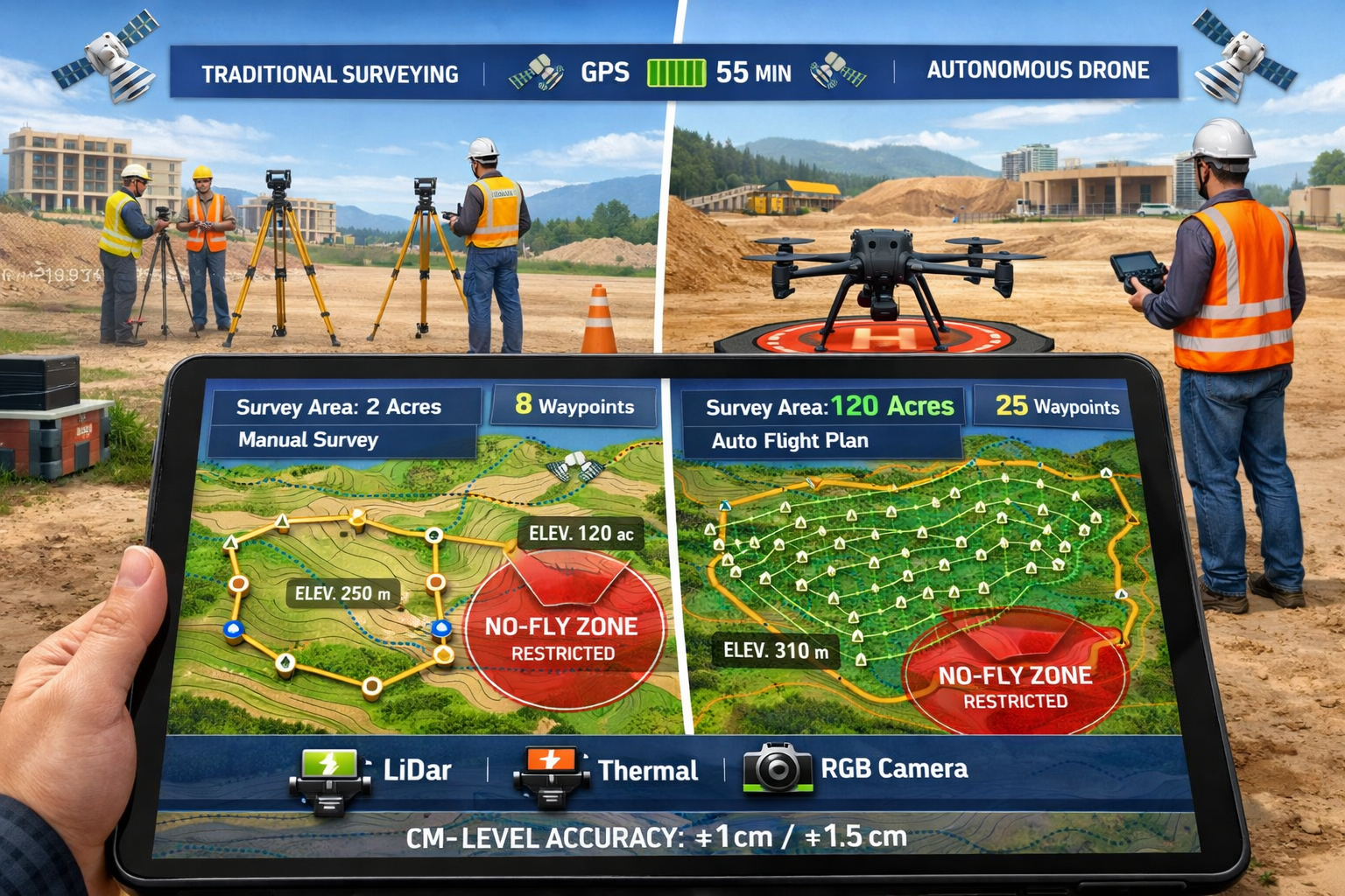
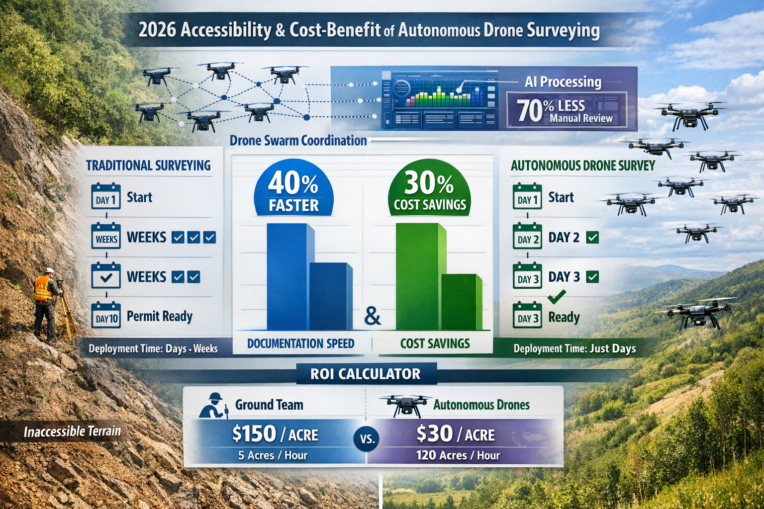
✈️ Speed Revolution: Autonomous drones can survey 120 acres per hour compared to just 5 acres per hour for traditional ground teams, reducing a 12-acre property survey from 100 hours to approximately 2 hours[3][4]
💰 Cost Efficiency: Real-world implementations demonstrate 30% cost savings and 40% faster site documentation compared to legacy surveying workflows[3]
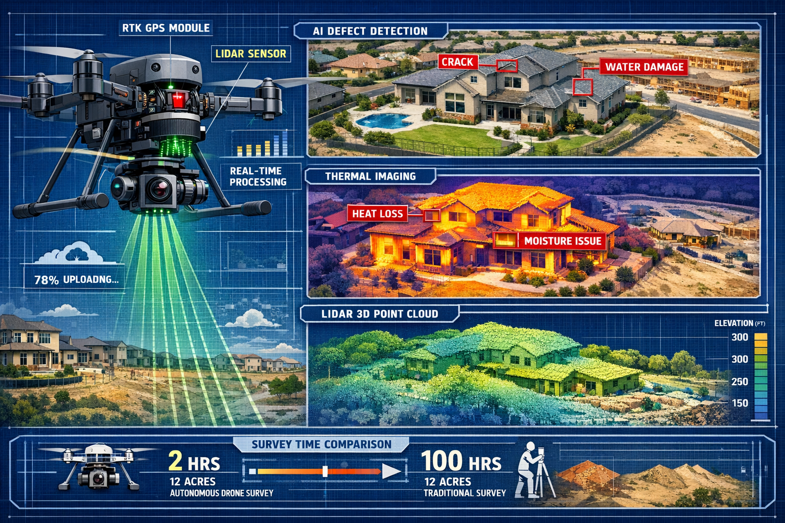
🎯 Centimeter-Level Precision: Modern autonomous systems deliver survey-grade accuracy through RTK GPS integration and multi-sensor data fusion[3]
🤖 AI-Powered Intelligence: Automated defect detection reduces manual data review time by 70%, while AI-driven flight planning optimizes coverage patterns without human intervention[3]
⚡ Rapid Deployment: Industry leaders now achieve permit-ready survey turnaround in 3 days or less, down from the traditional 10-day standard[1]
Understanding Autonomous Drone Technology in Property Surveying
What Makes Drones "Autonomous" in Surveying Applications?
The term "autonomous" in drone surveying refers to systems capable of executing complex missions with minimal human intervention. Unlike manually piloted drones that require constant operator control, autonomous surveying drones utilize sophisticated algorithms, GPS navigation, and artificial intelligence to plan routes, adjust flight parameters in real-time, and optimize data collection independently.
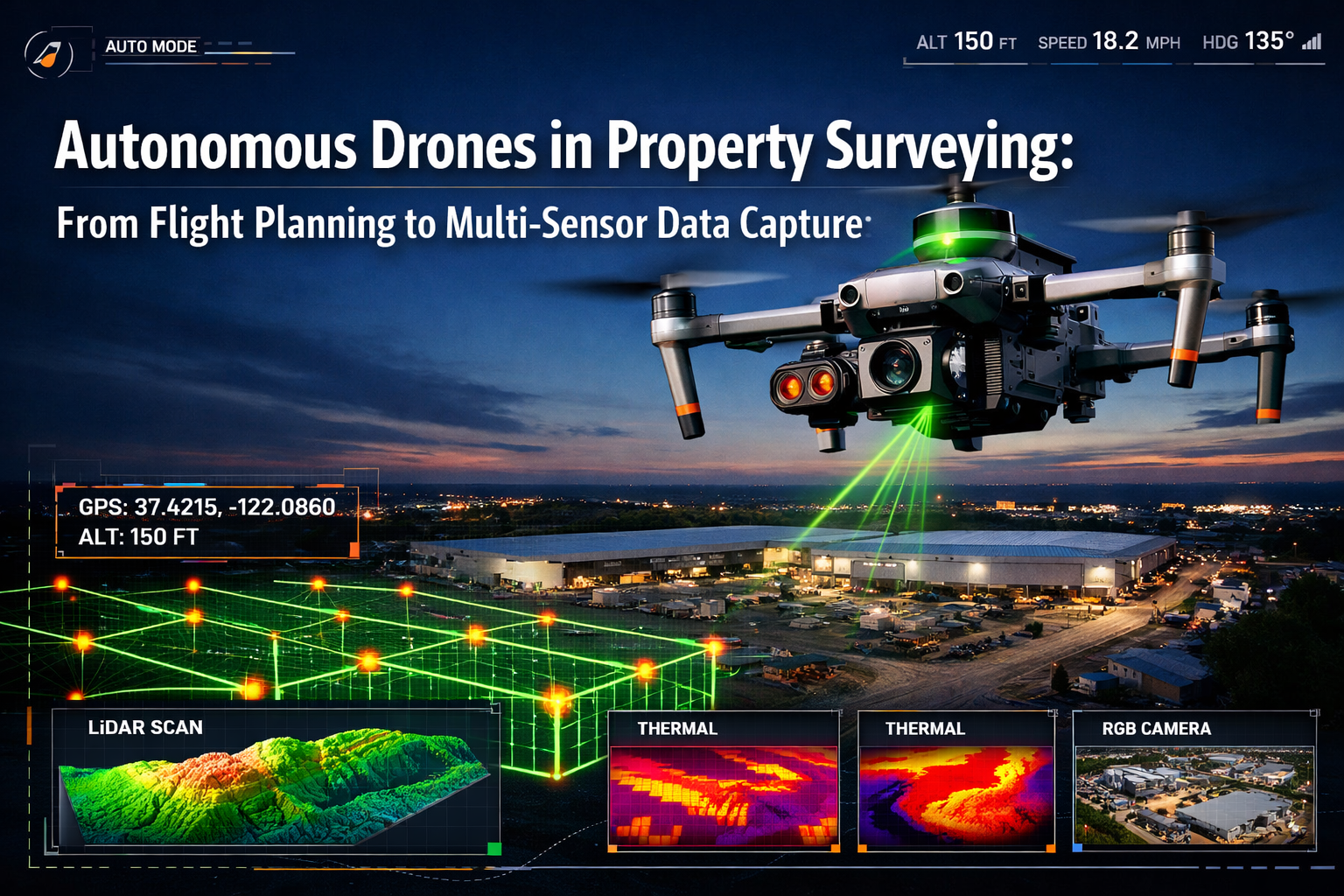
Modern autonomous platforms like the DJI Matrice 350 RTK represent the current generation of surveying hardware, featuring up to 55 minutes of flight time and support for multiple sensor payloads including LiDAR, thermal imaging, and high-resolution RGB cameras[3]. These systems integrate Real-Time Kinematic (RTK) positioning to achieve centimeter-level accuracy—a critical requirement for professional commercial property surveying applications.
The breakthrough in 2025 was the commercial deployment of fully autonomous AI-powered drones that fundamentally changed surveying workflows[3]. These systems can now:
- Automatically generate optimal flight paths based on property boundaries and terrain
- Adjust altitude and camera angles to maintain consistent ground sampling distance
- Detect and avoid obstacles including buildings, trees, and power lines
- Compensate for wind and lighting conditions to ensure data quality
- Coordinate with multiple drones in swarm configurations for large-scale projects[2]
The Multi-Sensor Advantage
What distinguishes modern autonomous surveying from simple aerial photography is the integration of multiple sensor types that capture complementary data simultaneously. A typical autonomous surveying mission might deploy:
| Sensor Type | Primary Use | Key Benefits |
|---|---|---|
| RGB Camera | Visual documentation, orthomosaic creation | High-resolution imagery for detailed inspection |
| LiDAR | Terrain mapping, volumetric analysis | Penetrates vegetation, accurate elevation data |
| Thermal Imaging | Building envelope analysis, moisture detection | Identifies insulation issues, water intrusion |
| Multispectral | Vegetation health, land use classification | Environmental assessment, agricultural analysis |
This multi-sensor approach transforms raw aerial data into actionable intelligence for RICS chartered building surveyors and property professionals. The autonomous systems intelligently manage sensor activation, exposure settings, and capture intervals to optimize data quality while maximizing battery efficiency.
Flight Planning: The Foundation of Autonomous Drone Surveying
Automated Mission Design and Optimization
Flight planning represents the critical first phase in Autonomous Drones in Property Surveying: From Flight Planning to Multi-Sensor Data Capture workflows. Modern autonomous systems have revolutionized this process through intelligent automation that eliminates much of the manual calculation and guesswork that characterized earlier drone operations.
Automated flight planning software now analyzes property boundaries, identifies obstacles, calculates optimal flight altitudes, and generates waypoint paths in minutes rather than hours. The system considers multiple variables simultaneously:
- Ground Sampling Distance (GSD): Determines flight altitude to achieve required image resolution
- Image Overlap: Calculates front and side overlap percentages (typically 70-80%) for accurate photogrammetry
- Battery Optimization: Plans missions within flight time limits, including return-to-home safety margins
- Regulatory Compliance: Automatically incorporates no-fly zones, altitude restrictions, and airspace limitations
- Terrain Following: Adjusts altitude dynamically to maintain consistent GSD over varying elevations
The efficiency gains are substantial. Where traditional surveying required extensive pre-planning and multiple site visits, autonomous drones can be deployed within days rather than weeks or months[5]. This rapid deployment capability has proven particularly valuable for time-sensitive projects such as RICS home surveys where quick turnaround directly impacts transaction timelines.
Real-Time Adaptive Intelligence
Perhaps the most significant advancement in 2026 is the autonomous system's ability to self-adjust during active missions. Modern AI-powered flight software continuously analyzes incoming data and modifies flight parameters in real-time to optimize results:
🔄 Dynamic Route Adjustment: If initial passes reveal areas requiring higher resolution, the system automatically plans additional coverage
🌤️ Lighting Compensation: Adjusts camera settings and flight timing to account for changing sun angles and cloud cover
⚠️ Obstacle Response: Detects previously unmapped obstacles and recalculates safe flight paths without aborting the mission
📊 Data Quality Monitoring: Analyzes image quality during capture and re-flies sections with insufficient clarity or overlap
This adaptive capability ensures comprehensive coverage even on complex properties with challenging terrain or structures. For professionals conducting building surveys, this means fewer return visits and more complete initial data sets.
Integration with Professional Surveying Workflows
The true power of autonomous flight planning emerges when integrated into broader surveying workflows. Leading providers like ZenaTech's Drone as a Service have developed comprehensive builder services that include topography, plot plans, boundary validation, zoning compliance, and jurisdiction-specific formatting—all critical for permit acquisition[1].
This integration addresses a fundamental industry challenge: reducing permit-ready survey turnaround from 10 days to 3 days or less[1]. ZenaTech's acquisition of Cardinal Civil Resources in 2025 specifically targeted this opportunity, leveraging Cardinal's 15+ year relationships with major homebuilders including Ryan Homes (NVR Inc.) to scale drone-based surveying operations[1].
The workflow automation extends beyond flight execution to include:
- Automated data processing pipelines that convert raw sensor data into deliverable formats
- Cloud-based collaboration platforms enabling real-time access for stakeholders
- AI-powered quality assurance that flags potential issues before final delivery
- Standardized output formats compatible with CAD, GIS, and BIM software
Multi-Sensor Data Capture: Transforming Raw Flights into Actionable Intelligence
Simultaneous Multi-Modal Data Collection
The evolution of Autonomous Drones in Property Surveying: From Flight Planning to Multi-Sensor Data Capture has fundamentally changed what's possible during a single surveying mission. Modern autonomous platforms capture multiple data types simultaneously, creating rich, multi-dimensional property documentation that would require separate visits using traditional methods.
Consider a typical autonomous survey of a commercial development site:
RGB Imaging captures high-resolution photographs (often 20+ megapixels) that are processed into orthomosaic maps providing accurate, georeferenced visual documentation of the entire property. These orthomosaics serve as the foundation for commercial building surveys and provide measurable imagery for distance, area, and volume calculations.
LiDAR sensors emit thousands of laser pulses per second, creating detailed three-dimensional point clouds that accurately represent terrain and structures. This technology excels at penetrating vegetation to reveal ground-level topography—essential for accurate boundary surveys and flood risk assessment. The point cloud data enables precise volumetric calculations for earthwork estimation and stockpile measurement.
Thermal imaging cameras detect temperature variations across building envelopes, identifying insulation deficiencies, moisture intrusion, and HVAC system performance issues. For damp surveys and building diagnostics, thermal data provides non-invasive insights that would otherwise require extensive physical inspection.
Multispectral sensors capture data beyond visible light wavelengths, revealing vegetation health, drainage patterns, and land use characteristics critical for environmental assessments and agricultural property evaluation.
Processing Power: From Raw Data to Deliverable Intelligence
The volume of data generated during autonomous multi-sensor surveys is staggering—a single mission might produce thousands of images, billions of LiDAR points, and gigabytes of thermal and multispectral information. The challenge isn't just capturing this data but transforming it into actionable intelligence that property professionals can use.
AI-powered processing pipelines have become essential to managing this data deluge. In 2024 Arizona construction projects, AI-driven defect detection reduced manual data review time by 70% compared to traditional manual analysis[3]. These systems automatically:
- Identify structural anomalies such as cracks, settlement, and material defects
- Classify features including buildings, vegetation, water bodies, and infrastructure
- Generate measurements for areas, volumes, distances, and elevations
- Detect changes by comparing current surveys with historical data
- Flag compliance issues related to setbacks, height restrictions, and zoning requirements
The processing workflow typically progresses through several automated stages:
- Image alignment and georeferencing using RTK GPS data and ground control points
- Point cloud generation through photogrammetric or LiDAR processing
- Surface model creation including Digital Terrain Models (DTM) and Digital Surface Models (DSM)
- Feature extraction identifying buildings, boundaries, and site elements
- Analysis and measurement calculating areas, volumes, and compliance metrics
- Report generation producing standardized deliverables in required formats
Accuracy and Validation: Ensuring Survey-Grade Results
For autonomous drone surveying to replace traditional methods in professional applications like RICS valuations, the data must meet rigorous accuracy standards. Modern autonomous systems achieve centimeter-level precision through several complementary technologies[3]:
RTK GPS Integration: Real-Time Kinematic positioning uses corrections from base stations or satellite networks to achieve horizontal accuracy of ±2-3 cm and vertical accuracy of ±5 cm. This eliminates the need for extensive ground control point networks that previously required significant field time.
Ground Control Points (GCPs): For maximum accuracy, strategically placed survey markers with known coordinates provide reference points for data processing. Autonomous systems can be programmed to automatically capture detailed imagery of GCPs during missions.
Redundant Data Capture: High image overlap (70-80%) ensures every point on the ground appears in multiple photographs from different angles, enabling robust photogrammetric reconstruction and error detection.
Multi-Sensor Fusion: Combining data from multiple sensor types provides cross-validation opportunities. For example, LiDAR-derived elevations can verify photogrammetric surface models, while RGB imagery confirms thermal anomaly locations.
Validation studies consistently demonstrate that properly executed autonomous drone surveys match or exceed the accuracy of traditional ground surveys for most applications, while dramatically reducing time and cost requirements.
Cost-Benefit Analysis: The Economic Case for Autonomous Drone Surveying
Quantifying Time Savings Across Project Types
The economic advantages of Autonomous Drones in Property Surveying: From Flight Planning to Multi-Sensor Data Capture become immediately apparent when comparing project timelines. Real-world data from 2024-2026 implementations demonstrates consistent, dramatic time reductions:
Large-Scale Property Surveys: Autonomous drones capture 120 acres per hour compared to just 5 acres per hour for traditional ground survey teams[3]. For a typical 100-acre development site, this translates to less than one hour of flight time versus 20 hours of field work—not including setup, breakdown, and travel between survey points.
Medium-Sized Commercial Properties: A 12-acre commercial property that would require approximately 100 hours of traditional surveying can be comprehensively documented in roughly 2 hours using autonomous drone technology[4]. This includes flight time, battery changes, and basic quality checks—the bulk of processing occurs automatically afterward.
Residential Property Assessments: Even smaller properties benefit from autonomous surveying efficiency. A detailed roof survey that might require hours of ladder work, safety equipment setup, and manual measurement can be completed in 15-20 minutes of flight time, with comprehensive imagery capturing details impossible to document from ground level.
Permit-Ready Documentation: Perhaps the most significant timeline improvement comes from workflow integration. Industry leaders now achieve permit-ready survey turnaround in 3 days or less, down from the traditional 10-day standard[1]. This acceleration directly impacts project schedules, enabling faster approvals and earlier construction starts.
Direct Cost Reductions and ROI Calculations
Time savings translate directly into cost reductions across multiple expense categories:
💰 Labor Costs: Autonomous drone operations typically require 1-2 operators compared to 3-5 person survey crews. Arizona projects documented 30% cost savings compared to traditional workflows[3], with labor representing the largest component of this reduction.
🚗 Travel and Logistics: Drone equipment is compact and portable, eliminating the need for multiple vehicles, extensive equipment transport, and repeated site visits. A single operator can complete multiple property surveys in a day that would require weeks using traditional methods.
⚠️ Safety and Insurance: Autonomous drones eliminate many hazardous situations including roof access, steep terrain navigation, and traffic exposure. Reduced risk translates to lower insurance premiums and fewer safety-related delays.
📊 Data Quality and Rework: The comprehensive nature of multi-sensor data capture means fewer return visits for additional measurements. AI-powered quality assurance catches issues before surveyors leave the site, virtually eliminating costly rework.
A typical ROI calculation for a mid-sized surveying firm might look like this:
Initial Investment: $50,000-$100,000 (drone hardware, sensors, software licenses, training)
Monthly Operating Costs: $2,000-$5,000 (insurance, software subscriptions, maintenance)
Revenue Impact: 3-5x increase in survey capacity, enabling $20,000-$50,000 additional monthly revenue
Payback Period: 6-12 months for firms with consistent project flow
Accessibility Improvements in 2026
The 2026 surveying landscape has seen significant improvements in accessibility that further enhance the value proposition of autonomous drone technology:
Reduced Technical Barriers: Modern autonomous systems feature intuitive interfaces that require minimal piloting expertise. Automated flight planning and execution mean surveyors can focus on interpreting results rather than mastering complex drone operation. This democratization enables smaller firms and independent professionals to access capabilities previously limited to large organizations with dedicated drone departments.
Cloud-Based Processing: Advanced processing that once required expensive workstations and specialized software now occurs in the cloud. Surveyors upload raw data and receive processed deliverables without investing in high-end hardware. This subscription-based model converts large capital expenditures into manageable operating expenses.
Regulatory Streamlining: Improved regulatory frameworks in many jurisdictions have simplified commercial drone operations. Automated compliance features built into flight planning software ensure operations remain within legal parameters, reducing the administrative burden on operators.
Service Provider Networks: The emergence of Drone as a Service (DaaS) providers like ZenaTech enables property professionals to access autonomous surveying capabilities without equipment ownership. This model is particularly attractive for occasional users or those testing the technology before committing to full implementation[1].
Improved Data Accessibility: Modern platforms deliver survey data through web-based interfaces accessible on any device. Stakeholders can view, measure, and analyze property data without specialized software, improving collaboration and decision-making speed. This accessibility proves particularly valuable for homebuyer surveys where clients appreciate visual, easily understood documentation.
Practical Applications Across Property Surveying Disciplines
Topographic and Boundary Surveys
Autonomous drones have revolutionized topographic surveying by enabling rapid, comprehensive terrain documentation. The combination of photogrammetry and LiDAR creates highly accurate Digital Terrain Models (DTM) that reveal ground surface characteristics even through dense vegetation.
For boundary surveys, autonomous systems capture detailed imagery of property corners, monuments, and boundary features while simultaneously documenting surrounding context. The georeferenced data integrates seamlessly with legal descriptions and GIS databases, supporting RICS specific defect surveys and boundary dispute resolution.
Zoning and compliance verification benefits particularly from autonomous drone capabilities. Comprehensive aerial documentation enables accurate measurement of setbacks, building heights, impervious surface coverage, and other zoning parameters. Automated analysis flags potential violations before they become costly compliance issues.
Construction Progress Monitoring
The construction industry has embraced autonomous drone surveying for regular progress documentation. Weekly or monthly autonomous flights create time-stamped records of site conditions, enabling:
- Comparison against project schedules to identify delays or deviations
- Volumetric analysis of earthwork, stockpiles, and material quantities
- Quality assurance through detailed visual documentation
- Stakeholder communication via easily accessible visual progress reports
The 40% improvement in documentation speed demonstrated in Arizona construction projects[3] enables more frequent monitoring without proportional cost increases. This frequent documentation proves invaluable for project management and dispute resolution.
Building Condition Assessments
Multi-sensor autonomous drones excel at comprehensive building condition documentation. A single flight captures:
Visual Inspection Data: High-resolution imagery reveals surface defects, material deterioration, and maintenance needs across roofs, facades, and other building elements
Thermal Analysis: Identifies insulation deficiencies, moisture intrusion, and HVAC system inefficiencies without invasive testing
Dimensional Verification: Confirms as-built conditions match design documents, supporting reinstatement valuations and insurance assessments
Safety Hazard Identification: Documents potential hazards including loose materials, structural damage, and access issues without exposing inspectors to risk
This comprehensive approach supports various assessment types including subsidence surveys, dilapidation surveys, and routine maintenance planning.
Environmental and Agricultural Property Assessment
For properties with significant environmental or agricultural components, multispectral and thermal sensors provide insights impossible to obtain through traditional surveying:
- Vegetation health mapping identifies stressed or diseased plants
- Drainage pattern analysis reveals water flow and potential flooding issues
- Soil moisture assessment supports irrigation planning and drought monitoring
- Habitat documentation aids environmental compliance and conservation planning
These capabilities prove particularly valuable for large rural properties, conservation easements, and agricultural operations where comprehensive ground-based assessment would be prohibitively expensive.
Overcoming Implementation Challenges and Best Practices
Regulatory Compliance and Airspace Management
While autonomous drone technology offers tremendous capabilities, successful implementation requires careful attention to regulatory requirements. In 2026, most jurisdictions require:
Operator Certification: Commercial drone pilots typically need specific licenses or certifications, though requirements vary by location and operation type
Airspace Authorization: Operations near airports, in controlled airspace, or above certain altitudes require advance approval from aviation authorities
Privacy Considerations: Surveying residential properties requires sensitivity to privacy concerns and may necessitate neighbor notification
Insurance Requirements: Professional liability and hull insurance protect against equipment damage and third-party claims
Best practice involves integrating compliance checks into the flight planning process. Modern autonomous systems include airspace databases and automated authorization request features that streamline regulatory compliance.
Data Management and Security
The volume of data generated by autonomous multi-sensor surveys creates significant management challenges. Effective data governance requires:
Structured Storage Systems: Organized file structures with consistent naming conventions enable efficient data retrieval
Backup Protocols: Redundant storage protects against data loss from equipment failure or human error
Security Measures: Encryption and access controls protect sensitive client information and proprietary survey data
Retention Policies: Clear guidelines for data retention duration balance storage costs against potential future needs
Cloud-based platforms increasingly handle these requirements automatically, though firms must still ensure compliance with data protection regulations and client confidentiality requirements.
Quality Assurance and Validation Procedures
Even with automated processing, human oversight remains essential for ensuring survey accuracy and completeness. Recommended quality assurance procedures include:
✅ Pre-Flight Verification: Confirm equipment calibration, battery charge, and environmental conditions before launching missions
✅ Real-Time Monitoring: Observe flight progress to identify potential issues requiring intervention
✅ Post-Flight Review: Verify data completeness and quality before leaving the site
✅ Processing Validation: Check automated processing results against known reference points
✅ Deliverable Review: Ensure final reports and data products meet client requirements and professional standards
These procedures ensure that the efficiency gains from autonomous operation don't compromise the accuracy and reliability that professional surveying demands.
Training and Skill Development
Successful autonomous drone surveying requires a blend of traditional surveying knowledge and new technical skills. Effective training programs address:
- Fundamental drone operation including manual flight skills for emergency situations
- Autonomous system configuration and flight planning software
- Sensor selection and optimization for different surveying objectives
- Data processing workflows and quality control procedures
- Regulatory compliance and risk management
Many organizations find that combining experienced surveyors with drone technology specialists creates effective teams that leverage both traditional expertise and emerging capabilities.
Future Trends: What's Next for Autonomous Drone Surveying
AI and Machine Learning Advancements
The AI capabilities demonstrated in 2024-2025, which reduced manual review time by 70%[3], represent just the beginning of machine learning's impact on surveying. Emerging developments include:
Predictive Maintenance Analysis: AI systems that analyze building condition data to predict future maintenance needs and lifecycle costs
Automated Feature Classification: Increasingly sophisticated algorithms that automatically identify and categorize site features, reducing manual digitization requirements
Change Detection Automation: Systems that automatically compare sequential surveys to identify and quantify changes over time
Intelligent Mission Planning: AI that learns from previous surveys to optimize flight parameters for specific property types and surveying objectives
Swarm Technology and Coordinated Operations
The emergence of autonomous drone swarms working together with minimal human intervention[2] promises to further accelerate surveying timelines. Multiple drones coordinating to survey large properties simultaneously could reduce survey time from hours to minutes while maintaining comprehensive coverage and data quality.
Swarm technology also enables specialized sensor deployment, with different drones carrying optimized sensor packages for specific data types, all operating simultaneously to create comprehensive multi-modal datasets in a single coordinated mission.
Integration with Digital Twins and BIM
The future of property surveying increasingly involves integration with Building Information Modeling (BIM) and digital twin platforms. Autonomous drone surveys provide the as-built data that keeps these digital models current and accurate, enabling:
- Real-time facility management based on current conditions
- Predictive modeling for renovation and expansion planning
- Energy performance optimization using thermal and structural data
- Lifecycle cost analysis informed by actual condition data
This integration transforms surveying from a periodic assessment activity into continuous property intelligence gathering that supports ongoing decision-making.
Expanded Sensor Capabilities
Emerging sensor technologies will further expand autonomous drone surveying capabilities:
Gas Detection Sensors: Identify methane leaks, air quality issues, and environmental hazards
Ground-Penetrating Radar: Reveal subsurface features including utilities, foundations, and archaeological elements
Acoustic Sensors: Detect mechanical issues in HVAC systems, generators, and other equipment
Advanced Spectral Imaging: Provide material composition analysis and contamination detection
These capabilities will enable increasingly comprehensive property assessments from aerial platforms, reducing or eliminating the need for ground-based investigation in many scenarios.
Conclusion: Embracing the Autonomous Surveying Revolution
Autonomous Drones in Property Surveying: From Flight Planning to Multi-Sensor Data Capture represents far more than incremental improvement over traditional methods—it constitutes a fundamental transformation in how property professionals gather, analyze, and utilize spatial data. The technology has matured from experimental novelty to proven, reliable tool that delivers measurable advantages in speed, cost, accuracy, and comprehensiveness.
The data speaks compellingly: 120 acres per hour versus 5 acres, 2 hours versus 100 hours, 3 days versus 10 days for permit-ready deliverables[1][3][4]. These aren't marginal improvements—they represent order-of-magnitude changes that fundamentally alter project economics and timelines.
For property professionals, the strategic question is no longer whether to adopt autonomous drone surveying, but how quickly to implement it and which applications to prioritize. The 2026 accessibility improvements—including intuitive interfaces, cloud-based processing, and Drone as a Service options—have removed many traditional barriers to adoption.
Actionable Next Steps
For organizations ready to embrace autonomous drone surveying:
1️⃣ Assess Current Workflows: Identify surveying activities that consume significant time and resources, particularly those involving large properties, difficult access, or frequent repetition
2️⃣ Evaluate Implementation Options: Consider whether equipment ownership, service provider partnerships, or hybrid approaches best fit your organization's needs and project mix
3️⃣ Start with Pilot Projects: Test autonomous surveying on non-critical projects to develop capabilities and demonstrate value before full-scale implementation
4️⃣ Invest in Training: Ensure team members develop both technical drone operation skills and data interpretation capabilities to maximize technology value
5️⃣ Establish Quality Standards: Define accuracy requirements, deliverable formats, and validation procedures that maintain professional standards while leveraging automation
6️⃣ Build Client Education: Help clients understand the advantages of drone-based surveying and how to interpret and utilize the comprehensive data it provides
7️⃣ Monitor Technology Evolution: Stay informed about emerging capabilities including AI advancements, new sensors, and regulatory changes that may create additional opportunities
The autonomous drone revolution in property surveying is well underway. Organizations that embrace these capabilities position themselves to deliver faster, more comprehensive, and more cost-effective services that meet the evolving expectations of property owners, developers, and investors in 2026 and beyond.
Whether supporting commercial property surveying, residential assessments, or specialized applications, autonomous drones equipped with multi-sensor capabilities represent the future of spatial data collection. The question isn't if this technology will transform your surveying practice—it's how quickly you'll harness its potential to deliver superior value to your clients.
References
[1] Zenatech S Drone As A Service Expands Builder Services Capability Delivering Drone Driven Speed And Precision To Surveying For Homebuilders 1035808701 – https://markets.businessinsider.com/news/currencies/zenatech-s-drone-as-a-service-expands-builder-services-capability-delivering-drone-driven-speed-and-precision-to-surveying-for-homebuilders-1035808701
[2] How Technology Is Revolutionizing Land Surveys – https://www.firstchoicesurveying.com/blog/how-technology-is-revolutionizing-land-surveys
[3] Uav Construction – https://www.extremeaerialproductions.com/post/uav-construction
[4] Drones In Construction – https://uavcoach.com/drones-in-construction/
[5] Watch – https://www.youtube.com/watch?v=CSTodaZb4Vc
[6] Revolutionizing Land Surveying The Rise Of Drone Technology And Uav Applications In 2026 – https://nottinghillsurveyors.com/blog/revolutionizing-land-surveying-the-rise-of-drone-technology-and-uav-applications-in-2026
[7] Real Estate Drone Services Global Market Report – https://www.thebusinessresearchcompany.com/report/real-estate-drone-services-global-market-report