Property owners planning to build, buy, or resolve boundary disputes face a critical question in 2026: how much will a land survey actually cost? With inflation reshaping operational expenses, cutting-edge technology transforming surveying methods, and regional construction booms driving demand, understanding Land Survey Costs in 2026: What Property Owners Need to Know About Inflation, Tech Add-Ons, and Regional Pricing has never been more essential.
The landscape of land surveying has evolved dramatically. Traditional methods using theodolites and measuring tapes now compete with drone-assisted mapping 🚁, 3D laser scanning, and GPS-enabled precision equipment. These technological advances deliver unprecedented accuracy but come with premium price tags that property owners must factor into their budgets. Meanwhile, the national average land survey cost has reached $2,300 in 2026, with prices spanning an enormous range from $475 to $25,000 depending on complexity, location, and survey type[3].
This comprehensive guide breaks down exactly what property owners can expect to pay in 2026, examining how inflation, specialized technology add-ons, and geographic location influence final costs. Whether planning a residential fence installation, commercial development, or resolving a property line dispute, understanding these cost drivers helps property owners budget effectively and maximize their return on investment.
Key Takeaways
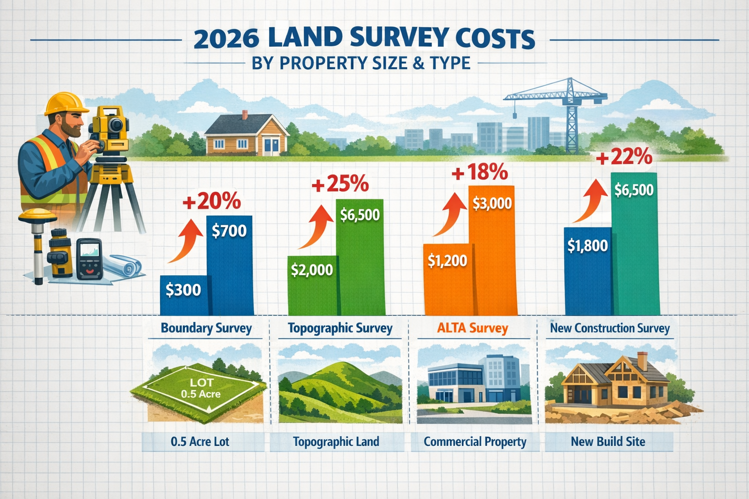
- Average land survey costs in 2026 range from $2,300 nationally, with simple boundary surveys starting at $300-$700 for typical residential lots and complex ALTA surveys reaching $1,200-$3,000 or more[3][4]
- Technology premiums significantly impact pricing, as drone mapping, 3D laser scanning, and advanced GPS equipment add 20-40% to base survey costs compared to traditional methods
- Regional pricing variations are substantial, with urban areas like New York and San Francisco charging $1,400-$6,000 while rural regions may offer comparable services for under $500[1][3]
- Property size directly correlates with cost, from small urban lots under one-eighth acre ($250-$400) to large acreage properties using per-acre pricing starting around $150 per acre[4]
- Professional surveys provide measurable ROI by preventing boundary disputes, facilitating accurate construction planning, and satisfying title insurance requirements that protect property values
Understanding the Baseline: What Land Surveys Cost in 2026
The foundation of Land Survey Costs in 2026: What Property Owners Need to Know About Inflation, Tech Add-Ons, and Regional Pricing begins with understanding baseline pricing for standard residential surveys. For a quarter-acre lot with clear boundaries in an established neighborhood, property owners can expect to pay approximately $525 in 2026[4]. This median residential survey assumes flat terrain, accessible property corners, and no active disputes—the ideal scenario for cost-conscious homeowners.
Standard Residential Survey Ranges
Most residential surveys fall into predictable pricing tiers based on property characteristics:
Small Urban Lots (Under 1/8 Acre)
- Cost Range: $250 to $400
- Typical Timeline: 1-2 days
- Best For: Townhomes, condos with land, small city lots
- Includes: Basic boundary identification and corner marking
Standard Residential Lots (1/8 to 1 Acre)
- Cost Range: $300 to $800
- Typical Timeline: 2-3 days
- Best For: Single-family homes in subdivisions
- Includes: Property line verification, plat preparation
Medium Properties (1 to 5 Acres)
- Cost Range: $800 to $1,500
- Typical Timeline: 3-5 days
- Best For: Larger suburban properties, small hobby farms
- Includes: Comprehensive boundary survey, topographic elements
Large Acreage (5+ Acres)
- Cost Range: $150+ per acre (starting point)
- Typical Timeline: 1-2 weeks
- Best For: Farms, ranches, undeveloped land
- Includes: Per-acre pricing with volume discounts
For perspective, surveying 6 acres may cost $1,500 to $2,800, while a 40-acre property could range from $4,000 to $12,000[2]. These figures reflect the labor-intensive nature of traversing larger properties and establishing multiple boundary markers across extensive perimeters.
National Average and Typical Spending Patterns
The national average of $2,300 represents a midpoint that encompasses various survey types and property complexities[3]. However, most homeowners actually spend between $800 and $5,500 for land surveys in 2026[5], with the wide range reflecting differences in:
- Survey type complexity (boundary vs. topographic vs. ALTA)
- Property accessibility (urban vs. rural, flat vs. mountainous)
- Record availability (well-documented vs. missing historical data)
- Local market conditions (competitive vs. limited surveyor availability)
Understanding these baseline costs provides the foundation for evaluating how inflation, technology, and regional factors modify final pricing. For property owners seeking detailed survey pricing information, consulting with RICS-certified professionals ensures accurate estimates tailored to specific property characteristics.
How Inflation Has Impacted Land Survey Costs in 2026
Inflation remains a persistent force reshaping Land Survey Costs in 2026: What Property Owners Need to Know About Inflation, Tech Add-Ons, and Regional Pricing. While base prices for standard surveys have not experienced dramatic spikes, operational expenses have crept upward, creating modest but measurable increases across the industry[1].
Operational Cost Drivers
Several inflation-related factors contribute to higher survey costs in 2026:
Labor and Personnel Expenses 💼
- Licensed surveyors command higher salaries due to workforce shortages
- Crew members receive competitive wages in tight labor markets
- Benefits and insurance costs continue rising year-over-year
- Average surveyor hourly rates now range $220 to $450 per hour[3]
Equipment and Technology Maintenance
- GPS equipment requires regular calibration and updates
- Drone technology demands ongoing licensing and maintenance
- Software subscriptions for CAD and mapping tools increase annually
- Vehicle fuel costs impact field work expenses
Regulatory and Insurance Requirements
- Professional liability insurance premiums rise with claim costs
- State licensing fees and continuing education requirements expand
- Compliance with updated surveying standards adds administrative overhead
Property Record Research Costs
- County office fees for accessing historical documents
- Digital record system subscriptions and access fees
- Additional $85 to $160 per hour for property record research[3]
Where Inflation Hits Hardest
Specialized services have absorbed the most significant cost increases, primarily due to technology advancements and regulatory demands[1]. ALTA surveys, which meet stringent title company standards, now cost $1,200 to $3,000 or more because they require:
- Comprehensive utility research and verification
- Detailed easement documentation and mapping
- Improvement location certification
- Zoning compliance verification
- Enhanced liability coverage
These surveys demand substantially more time and expertise than basic boundary surveys, making them particularly susceptible to inflation-driven cost increases.
Mitigating Inflation Impact
Property owners can take several steps to control costs despite inflationary pressures:
✅ Obtain property records independently from county offices to reduce research charges[3]
✅ Schedule surveys during off-peak seasons when surveyors offer competitive rates
✅ Bundle multiple services (boundary + topographic) for package discounts
✅ Compare quotes from multiple licensed surveyors to ensure competitive pricing
✅ Clarify exactly what survey type you need to avoid paying for unnecessary services
Understanding how inflation shapes survey costs helps property owners budget realistically while identifying opportunities to minimize expenses without compromising quality. For those working with chartered surveyors, discussing cost-saving strategies upfront can yield significant savings.
Technology Add-Ons: Drone Mapping, 3D Scanning, and Premium Services
The most dramatic cost variations in Land Survey Costs in 2026: What Property Owners Need to Know About Inflation, Tech Add-Ons, and Regional Pricing stem from technology-driven premium services. Modern surveying equipment delivers unprecedented accuracy and efficiency, but these advantages come with substantial price premiums that property owners must evaluate carefully.
Advanced Technology Options and Costs
Drone-Assisted Aerial Mapping 🚁
Unmanned aerial vehicles (UAVs) have revolutionized topographic surveying, particularly for larger properties and complex terrain. Drone mapping offers:
- Cost Premium: 25-35% above traditional methods
- Advantages: Rapid data collection, comprehensive aerial imagery, difficult terrain access
- Best Applications: Properties over 5 acres, steep slopes, heavily wooded areas
- Deliverables: Orthomosaic maps, 3D terrain models, volumetric calculations
A standard topographic survey costing $2,000 to $6,500 may increase to $2,500 to $8,500 with drone mapping integration[3]. However, the time savings often justify the premium for properties where traditional surveying would require extensive manual measurements.
3D Laser Scanning Technology
LiDAR (Light Detection and Ranging) and terrestrial laser scanning create extraordinarily detailed point clouds representing property features:
- Cost Premium: 30-40% above conventional surveys
- Advantages: Millimeter-level accuracy, comprehensive as-built documentation, digital twin creation
- Best Applications: Commercial properties, historic buildings, complex improvements
- Deliverables: Detailed 3D models, precise measurements, virtual property tours
For as-built surveys ranging $1,600 to $3,800 using traditional methods[3], 3D scanning might increase costs to $2,100 to $5,300, but provides documentation that supports future renovations, expansions, and facility management.
GPS and RTK (Real-Time Kinematic) Systems
Modern GPS equipment with RTK correction delivers centimeter-level accuracy:
- Cost Premium: 15-20% above traditional total station surveys
- Advantages: Faster boundary establishment, integration with GIS systems, permanent coordinate records
- Best Applications: Large acreage, properties requiring precise georeferencing
- Deliverables: Coordinate-based boundary descriptions, GPS-compatible data files
Comparing Technology Costs: Traditional vs. Advanced Methods
| Survey Type | Traditional Method | With Technology Add-Ons | Premium % |
|---|---|---|---|
| Boundary Survey (1 acre) | $500-$700 | $600-$900 | 20-30% |
| Topographic Survey (5 acres) | $2,000-$4,000 | $2,500-$5,600 | 25-40% |
| ALTA Survey (commercial) | $1,200-$3,000 | $1,800-$4,200 | 40-50% |
| As-Built Survey | $1,600-$3,800 | $2,100-$5,300 | 30-40% |
When Technology Premiums Make Sense
Property owners should consider technology add-ons when:
🎯 Property complexity justifies precision – Irregular boundaries, multiple easements, or disputed areas benefit from enhanced accuracy
🎯 Time sensitivity matters – Drone surveys complete in hours what traditional methods require days to accomplish
🎯 Future development is planned – 3D models and digital twins support architectural design and construction planning
🎯 Documentation requirements are stringent – Commercial transactions, title insurance, or legal proceedings demand comprehensive records
🎯 Terrain presents access challenges – Steep slopes, water features, or dense vegetation make traditional surveying difficult
Construction Boom Surcharges
Beyond technology premiums, construction boom surcharges impact survey costs in high-growth regions. Areas experiencing rapid development face:
- Extended wait times (4-8 weeks vs. 1-2 weeks in normal markets)
- Rush service premiums (15-25% additional for expedited completion)
- Seasonal demand pricing (spring/summer peak rates 10-20% higher)
- Limited surveyor availability driving competitive bidding
Property owners in booming markets like Austin, Boise, Phoenix, and Charlotte should budget an additional 15-30% above national averages to secure timely survey services[1].
For those requiring specialized assessments, exploring options like commercial building surveys or structural surveys helps identify the right technology level for specific property needs.
Regional Pricing Variations: Urban vs. Rural and Geographic Differences
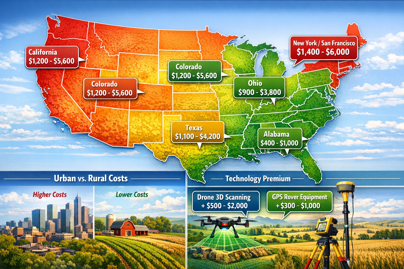
Geographic location creates some of the most significant variations in Land Survey Costs in 2026: What Property Owners Need to Know About Inflation, Tech Add-Ons, and Regional Pricing. A boundary survey that costs $400 in rural Alabama might exceed $1,500 in downtown San Francisco, even for comparable property sizes[3][6].
Major Metropolitan Area Pricing
High-Cost Urban Markets
Cities with elevated costs of living, intense real estate activity, and limited surveyor availability command premium rates:
New York City & San Francisco
- Cost Range: $1,400 to $6,000
- Driving Factors: Extreme property values, complex zoning, high operational costs
- Typical Residential Survey: $2,200-$3,500
- Commercial/ALTA Surveys: $4,000-$8,000+
California (Statewide Average)
- Cost Range: $1,200 to $5,600
- Driving Factors: Strict regulations, seismic considerations, environmental requirements
- Typical Residential Survey: $1,800-$2,800
- Coastal vs. Inland: 30-40% premium in coastal counties
Colorado
- Cost Range: $1,200 to $5,600
- Driving Factors: Mountain terrain complexity, recreational property demand
- Typical Residential Survey: $1,500-$2,500
- Mountain Properties: 40-60% premium for difficult access
For property owners in these high-cost regions, working with chartered surveyors in London or other major metropolitan areas often means paying premium rates but receiving service from highly experienced professionals familiar with complex urban property challenges.
Mid-Range Regional Markets
Texas
- Cost Range: $1,100 to $4,200
- Driving Factors: Large property sizes, oil/gas easements, varied terrain
- Typical Residential Survey: $900-$1,500
- Rural Acreage: $150-$200 per acre
Ohio
- Cost Range: $900 to $3,800
- Driving Factors: Moderate cost of living, established property records
- Typical Residential Survey: $700-$1,200
- Agricultural Land: $100-$150 per acre
Low-Cost Rural Markets
Alabama
- Cost Range: $400 to $1,000
- Driving Factors: Lower operational costs, less competitive market
- Typical Residential Survey: $500-$700
- Rural Properties: Significantly below national average[6]
Rural Regions (National)
- Cost Range: $300 to $800 for standard residential
- Driving Factors: Reduced overhead, established property boundaries
- Typical Residential Survey: $500 or less[1]
- Large Acreage: $75-$125 per acre
Urban vs. Rural Cost Comparison
The urban-rural divide creates dramatic pricing differences:
| Location Type | Boundary Survey | Topographic Survey | ALTA Survey |
|---|---|---|---|
| Major Urban | $800-$1,500 | $3,500-$8,000 | $2,500-$6,000 |
| Suburban | $500-$900 | $2,000-$4,500 | $1,500-$3,500 |
| Small Town | $400-$700 | $1,500-$3,500 | $1,200-$2,500 |
| Rural | $300-$500 | $1,200-$2,800 | $1,000-$2,000 |
Regional Factors Driving Price Variations
Cost of Living Adjustments
- Surveyor salaries reflect local wage standards
- Office rent and operational overhead vary dramatically
- Vehicle and equipment costs scale with regional fuel prices
Market Competition
- Urban areas with multiple surveyors create competitive pricing
- Rural regions with limited providers may charge premium rates for travel
- Seasonal demand fluctuations impact availability and pricing
Regulatory Environment
- States with strict licensing requirements limit surveyor supply
- Enhanced environmental regulations add compliance costs
- Local zoning complexity increases research and documentation time
Property Characteristics
- Mountainous terrain requires specialized equipment and expertise
- Coastal properties demand tidal and erosion considerations
- Desert regions present unique boundary marker challenges
Geographic-Specific Considerations
Property owners in specific regions should account for unique cost factors:
Southeast (Surrey, Sussex, Essex) 🏡
For UK property owners, chartered surveyors in Surrey, Sussex, and Essex offer specialized services tailored to regional property characteristics, with pricing reflecting local market conditions.
London and Surrounding Areas
Metropolitan regions like North London, South East London, and Central London command premium rates but provide access to highly specialized expertise for complex urban properties.
Affluent Suburban Markets
Areas like Chelsea, Richmond, and Hampstead reflect premium property values in survey pricing, with costs typically 30-50% above regional averages.
Understanding these regional variations helps property owners budget accurately and identify opportunities to reduce costs through strategic timing or surveyor selection.
Breaking Down Survey Types and Their 2026 Costs
Different property needs require different survey types, each with distinct pricing structures. Understanding these variations within Land Survey Costs in 2026: What Property Owners Need to Know About Inflation, Tech Add-Ons, and Regional Pricing helps property owners select the appropriate service level without overpaying for unnecessary features.
Boundary Surveys: The Most Affordable Option
Boundary surveys represent the most economical survey type, focusing exclusively on property line identification and corner marking[4].
Cost Range: $300 to $700 for typical residential lots
Complex Properties: $1,200 to $5,500[3][4]
What's Included:
- Property corner location and marking
- Boundary line establishment
- Basic plat or map preparation
- Comparison with deed descriptions
- Physical monument installation (stakes, iron pins)
Best For:
- Fence installation planning
- Resolving minor boundary questions
- Property line verification before purchase
- Establishing setback compliance
What's NOT Included:
- Topographic features or elevation data
- Utility location or easement verification
- Building improvement locations
- Title company certification
Boundary surveys provide the cheapest type of land survey[2] while delivering essential property line information for most residential needs. Property owners requiring only fence placement or basic boundary verification should specify boundary surveys to avoid unnecessary costs.
Topographic Surveys: Elevation and Feature Mapping
Topographic surveys document elevation changes, natural features, and existing improvements across the property.
Cost Range: $2,000 to $6,500[3]
What's Included:
- Contour lines showing elevation changes
- Natural features (trees, streams, rock outcroppings)
- Man-made improvements (buildings, driveways, utilities)
- Drainage patterns and water flow
- Detailed site mapping
Best For:
- New construction planning
- Site development and grading design
- Drainage and erosion control
- Architectural and engineering design
- Environmental impact assessments
Topographic surveys cost significantly more than boundary surveys due to the extensive field work required to measure and document elevation changes across the entire property. Drone-assisted topographic surveys can reduce field time while increasing accuracy, though they add 25-35% to base costs.
ALTA/NSPS Land Title Surveys: The Gold Standard
ALTA surveys meet the stringent standards established by the American Land Title Association and National Society of Professional Surveyors.
Cost Range: $1,200 to $3,000+[4]
What's Included:
- Comprehensive boundary survey
- All improvements and their locations
- Utility locations (above and below ground)
- Easement verification and mapping
- Zoning compliance verification
- Access and encroachment documentation
- Title company certification
Best For:
- Commercial property transactions
- Title insurance requirements
- Lender requirements for commercial loans
- Complex residential transactions
- Properties with easement concerns
ALTA surveys represent the most comprehensive and expensive survey type because they require extensive research, detailed field work, and professional certification that satisfies title insurance underwriters[4]. The premium reflects the surveyor's enhanced liability and the exhaustive documentation requirements.
Specialized Survey Types and Costs
Mortgage Location Surveys
- Cost: $1,500 to $4,500[3]
- Purpose: Verify improvement locations for lender requirements
- Includes: Building footprints, setback verification, basic easements
Fence Land Surveys
- Cost: $1,000 to $3,200[3]
- Purpose: Establish precise property lines for fence installation
- Includes: Boundary corners, line marking, setback verification
As-Built Surveys
- Cost: $1,600 to $3,800[3]
- Purpose: Document completed construction vs. approved plans
- Includes: Improvement locations, elevation verification, compliance certification
New Construction Surveys
- Cost: $1,800 to $6,500[3]
- Purpose: Support building permit applications and construction planning
- Includes: Boundary, topographic, and improvement location data
For property owners requiring specialized documentation, services like boundary surveys or RICS building surveys provide comprehensive assessments tailored to specific transaction or development needs.
Survey Type Selection Guide
Choosing the right survey type prevents overpaying for unnecessary features:
Choose a Boundary Survey if you need to:
- Install a fence along property lines
- Resolve a simple boundary question
- Verify property corners before purchase
- Establish basic setback compliance
Choose a Topographic Survey if you need to:
- Plan new construction or additions
- Design drainage or grading improvements
- Satisfy engineering or architectural requirements
- Assess development feasibility
Choose an ALTA Survey if you need to:
- Satisfy commercial lender requirements
- Obtain title insurance for complex properties
- Document all easements and encumbrances
- Support commercial property transactions
Choose a Specialized Survey if you need to:
- Document as-built construction conditions
- Verify improvement locations for mortgage purposes
- Support specific permit or compliance requirements
Understanding these distinctions helps property owners communicate clearly with surveyors and receive accurate quotes for services that match their actual needs.
Hidden Costs and Additional Factors Affecting Survey Pricing
Beyond the base survey type and property size, numerous hidden costs influence final pricing within Land Survey Costs in 2026: What Property Owners Need to Know About Inflation, Tech Add-Ons, and Regional Pricing. Property owners who understand these factors can budget more accurately and avoid unexpected expenses.
Record Availability and Research Costs
Surveyors rely heavily on public records to establish property boundaries and verify historical information. When records are incomplete or difficult to locate, additional charges apply[3].
Standard Record Research: $85 to $160 per hour[3]
Situations Requiring Extra Research:
- Properties with unclear or conflicting deed descriptions
- Subdivisions created before modern recording standards
- Properties that have changed hands many times
- Rural areas with incomplete county records
- Historical properties with outdated boundary descriptions
Cost-Saving Strategy: Property owners can reduce research costs by obtaining records directly from county offices before engaging a surveyor[3]. Providing the surveyor with:
- Current deed and legal description
- Previous survey plats (if available)
- Title insurance documents
- Easement records
- Subdivision plats
This preparation can save $200 to $500 in research fees for properties with complex ownership histories.
Terrain and Accessibility Challenges
Physical property characteristics significantly impact survey costs:
Steep Slopes and Mountainous Terrain
- Cost Impact: 30-50% premium
- Reason: Specialized equipment, safety measures, extended field time
- Mitigation: Drone-assisted surveys may reduce costs vs. traditional methods
Dense Vegetation and Wooded Properties
- Cost Impact: 20-40% premium
- Reason: Clearing sight lines, locating hidden corners, difficult access
- Mitigation: Winter surveys when foliage is minimal
Water Features and Wetlands
- Cost Impact: 25-45% premium
- Reason: Specialized equipment, regulatory compliance, access limitations
- Mitigation: Coordinate with environmental consultants for combined assessments
Remote or Difficult Access
- Cost Impact: 15-35% premium
- Reason: Travel time, equipment transportation, limited access points
- Mitigation: Provide detailed access information and clear pathways
Boundary Disputes and Legal Complications
Properties with active boundary disputes or legal complications require additional surveyor time and expertise:
Disputed Boundaries
- Cost Impact: 40-100% premium
- Includes: Extensive research, expert testimony preparation, detailed documentation
- Typical Range: $2,000-$8,000 depending on complexity
Encroachment Documentation
- Cost Impact: 25-50% premium
- Includes: Precise improvement measurements, photographic documentation, legal descriptions
- Typical Addition: $500-$2,000
Expert Witness Services
- Cost Impact: $250-$450 per hour for testimony and preparation[3]
- Includes: Deposition preparation, court appearances, expert reports
For property owners facing boundary issues, understanding what is a party wall dispute or reviewing boundary survey requirements helps clarify when specialized legal documentation becomes necessary.
Rush Services and Expedited Completion
Standard survey completion typically requires 1-3 weeks depending on complexity. Expedited services command premium pricing:
Rush Service Premiums:
- 1-Week Completion: 15-25% additional
- 3-Day Completion: 30-50% additional
- 24-Hour Rush: 75-100+ additional
Property owners should schedule surveys well in advance of closing dates or construction deadlines to avoid rush premiums.
Seasonal and Market Demand Factors
Survey costs fluctuate based on seasonal demand:
Peak Season (Spring/Summer)
- Cost Impact: 10-20% above off-season rates
- Wait Times: 4-8 weeks in busy markets
- Reason: Construction season, real estate activity peak
Off-Season (Fall/Winter)
- Cost Impact: Standard or discounted rates
- Wait Times: 1-3 weeks
- Advantages: Better availability, negotiable pricing, faster completion
Market-Specific Surcharges:
- Construction boom areas: 15-30% premium[1]
- Limited surveyor availability: 20-40% premium
- Competitive markets: Standard or below-average pricing
Property Improvement and Complexity Factors
The number and type of improvements on a property affect survey costs:
Minimal Improvements (vacant land)
- Cost Impact: Standard rates
- Surveyor Time: Focused on boundaries and topography
Standard Improvements (single residence, driveway)
- Cost Impact: Standard rates
- Surveyor Time: Basic improvement location documentation
Complex Improvements (multiple buildings, pools, extensive hardscaping)
- Cost Impact: 20-40% premium
- Surveyor Time: Detailed measurement and documentation of all features
Commercial/Industrial Improvements
- Cost Impact: 50-100+ premium
- Surveyor Time: Comprehensive improvement documentation, utility verification
Permit and Regulatory Requirements
Some jurisdictions impose additional requirements that increase survey costs:
Environmental Assessments
- Cost Impact: $500-$2,500 additional
- Includes: Wetland delineation, endangered species habitat identification
Zoning Verification and Certification
- Cost Impact: $200-$800 additional
- Includes: Setback verification, use compliance, variance documentation
Utility Coordination
- Cost Impact: $300-$1,200 additional
- Includes: Underground utility location (call before you dig), easement verification
Understanding these hidden costs helps property owners budget comprehensively and avoid surprises when final invoices arrive. Discussing potential additional charges upfront with surveyors ensures transparency and accurate cost projections.
Budgeting Tips and Cost-Saving Strategies for Property Owners
Smart property owners can reduce expenses without compromising quality by implementing strategic approaches to Land Survey Costs in 2026: What Property Owners Need to Know About Inflation, Tech Add-Ons, and Regional Pricing. These practical budgeting tips help maximize value while ensuring professional, accurate results.
Timing Your Survey Strategically
Off-Season Scheduling 📅
Scheduling surveys during slower periods yields significant savings:
✅ Fall/Winter Months: 10-20% below peak season rates
✅ Shorter Wait Times: 1-3 weeks vs. 4-8 weeks in spring
✅ Negotiation Leverage: Surveyors more willing to offer competitive pricing
✅ Better Availability: Access to senior surveyors and experienced crews
Exception: Heavily wooded properties may survey more efficiently in winter when foliage is minimal, potentially offsetting vegetation clearing costs.
Obtaining Records Independently
Property owners can save $200-$500 by gathering records before engaging a surveyor[3]:
Documents to Collect:
- Current deed and legal description (county recorder's office)
- Previous survey plats (title company or seller)
- Subdivision plats (county planning department)
- Easement records (utility companies, county records)
- Title insurance policy (lender or title company)
Time Investment: 2-4 hours
Typical Savings: $200-$500 in research fees
County offices increasingly offer online access to property records, making this research more convenient than ever.
Comparing Multiple Quotes
Obtain at least three quotes from licensed surveyors to ensure competitive pricing:
Quote Comparison Checklist:
- Surveyor licensing and insurance verification
- Detailed scope of work description
- Itemized cost breakdown
- Timeline and completion schedule
- Deliverables included (plat, report, digital files)
- Additional charges for common scenarios
- Professional references and recent project examples
Warning Signs:
- Quotes significantly below market average (may indicate inexperience or shortcuts)
- Vague scope descriptions without specific deliverables
- Unlicensed or uninsured surveyors
- No written contract or formal agreement
For comprehensive pricing information, reviewing survey pricing resources helps establish realistic expectations before soliciting quotes.
Bundling Services for Package Discounts
Property owners requiring multiple services can negotiate package discounts:
Common Bundles:
- Boundary + Topographic: 15-25% savings vs. separate surveys
- Survey + Staking: 10-20% savings on construction staking
- Multiple Properties: Volume discounts for investors or developers
Example Savings:
- Boundary survey alone: $600
- Topographic survey alone: $2,200
- Combined package: $2,400 (15% savings)
Clarifying Exactly What You Need
Avoid over-surveying by specifying the minimum service level that meets your needs:
Scenario 1: Fence Installation
- What You Need: Boundary survey with corner marking
- What You DON'T Need: Topographic data, improvement locations, ALTA certification
- Potential Savings: $500-$2,000
Scenario 2: Property Purchase
- What You Need: Depends on lender requirements and property complexity
- What You MIGHT NOT Need: Full ALTA survey for simple residential transactions
- Potential Savings: $400-$1,500
Scenario 3: New Construction
- What You Need: Boundary and topographic survey
- What You MIGHT NOT Need: Utility verification if provided by utility companies
- Potential Savings: $300-$800
Communicate clearly with surveyors about your specific purpose to receive tailored recommendations rather than default comprehensive packages.
Leveraging Technology Wisely
Evaluate technology add-ons based on actual value:
When Drone Mapping Makes Sense:
✅ Properties over 5 acres where time savings justify premium
✅ Difficult terrain where traditional surveying is extremely labor-intensive
✅ Projects requiring detailed aerial imagery for design purposes
When Traditional Methods Suffice:
✅ Small urban lots with good access
✅ Flat terrain with minimal vegetation
✅ Simple boundary verification without topographic needs
Potential Savings: $500-$2,000 by avoiding unnecessary technology premiums
Group Purchasing with Neighbors
Neighborhood survey initiatives can reduce per-property costs:
Subdivision Boundary Surveys:
- Individual cost: $600 per property
- Group rate (10+ properties): $400-$450 per property
- Savings: 25-33% per property owner
Shared Boundary Verification:
- When neighbors share disputed boundaries, splitting survey costs reduces individual expenses
- Typical savings: 40-50% vs. separate surveys
Maintaining Survey Records for Future Use
Preserve survey documentation to avoid repeat costs:
What to Keep:
- Original survey plat and report
- Digital files (CAD, PDF, coordinate data)
- Surveyor contact information
- Physical monument locations and descriptions
Future Value:
- Property improvements: Use existing surveys as baseline ($300-$800 savings)
- Future sales: Provide to buyers, reducing transaction costs
- Dispute resolution: Historical documentation prevents costly re-surveys
Understanding What Adds Real Value
Focus spending on elements that provide measurable returns:
High-Value Survey Elements:
- Accurate boundary identification (prevents costly disputes)
- Professional certification (satisfies lender/title requirements)
- Permanent monument installation (preserves boundaries long-term)
- Digital deliverables (supports future design and development)
Lower-Value Add-Ons:
- Excessive report formatting beyond functional needs
- Redundant documentation of obvious features
- Unnecessary premium materials for stakes/markers
By implementing these strategies, property owners can reduce survey costs by 20-40% while maintaining professional quality and accuracy. The key lies in understanding exactly what services provide value for specific situations and avoiding unnecessary premiums for features that don't advance project goals.
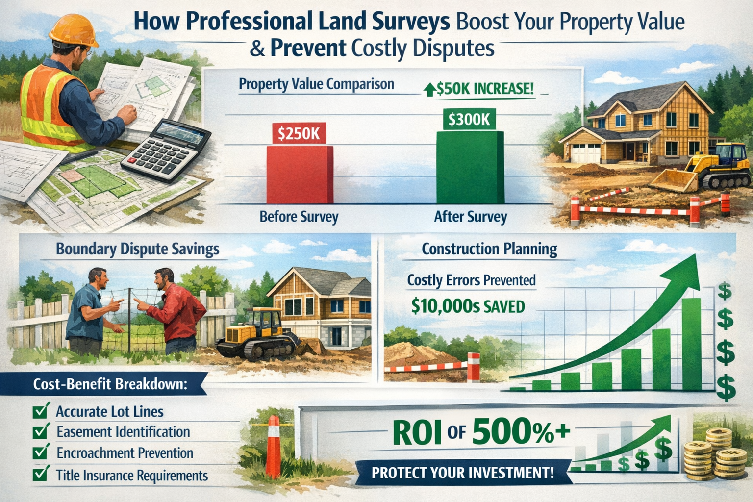
ROI Analysis: How Professional Surveys Boost Property Values
Understanding the return on investment from professional land surveys transforms them from perceived expenses into strategic property value enhancements. Within Land Survey Costs in 2026: What Property Owners Need to Know About Inflation, Tech Add-Ons, and Regional Pricing, the ROI analysis reveals how surveys deliver measurable financial benefits that far exceed their initial costs.
Preventing Costly Boundary Disputes
Boundary disputes represent one of the most expensive property-related legal issues homeowners face:
Average Boundary Dispute Costs:
- Legal fees: $5,000-$15,000
- Court costs and filing fees: $1,500-$3,500
- Expert witness fees: $2,000-$8,000
- Property damage remediation: $3,000-$12,000
- Total potential cost: $11,500-$38,500
Professional Survey Cost: $500-$1,500 for standard residential boundary survey
ROI Calculation:
- Investment: $1,000 (average boundary survey)
- Dispute prevention value: $20,000 (average dispute cost)
- Return: 1,900% or 19:1 ratio
A professional survey conducted before fence installation, landscaping, or construction prevents encroachment issues that lead to expensive legal battles. Property owners who invest in surveys upfront avoid the substantially higher costs of resolving disputes after improvements are constructed.
For those concerned about property boundary issues, understanding resources like boundary surveys or party wall agreements provides valuable context for prevention strategies.
Facilitating Accurate Construction Planning
Construction projects without proper surveys frequently encounter costly mid-project issues:
Common Construction Problems Without Surveys:
- Setback violations requiring redesign: $8,000-$25,000
- Utility line strikes during excavation: $5,000-$50,000
- Drainage problems from improper grading: $10,000-$30,000
- Encroachment on easements requiring relocation: $15,000-$75,000
Topographic Survey Cost: $2,000-$6,500 for residential properties
ROI Calculation:
- Investment: $4,000 (average topographic survey)
- Problem prevention value: $25,000 (average mid-construction issue)
- Return: 525% or 6.25:1 ratio
Professional surveys provide architects, engineers, and contractors with accurate data that prevents expensive design revisions, construction delays, and compliance violations. The relatively modest survey investment delivers substantial savings by identifying constraints and opportunities before construction begins.
Property owners planning significant improvements should consider comprehensive assessments through services like RICS building surveys or structural surveys to ensure proper planning.
Satisfying Title Insurance Requirements
Title insurance protects property owners and lenders from ownership disputes, but insurers increasingly require surveys for comprehensive coverage:
Title Issues Without Surveys:
- Survey exception on title policy (reduced coverage)
- Undiscovered easements affecting property use
- Encroachments not covered by insurance
- Boundary disputes excluded from coverage
Survey Exception Removal Value:
- Enhanced title insurance coverage: Full property value protection
- Marketability improvement: 2-5% easier sale process
- Lender confidence: Better loan terms and rates
ALTA Survey Cost: $1,200-$3,000 for residential properties
ROI Calculation:
- Investment: $2,000 (average ALTA survey)
- Property value protected: $400,000 (median home value)
- Coverage enhancement: Full protection vs. limited coverage
- Return: Comprehensive risk mitigation worth 200x investment
While harder to quantify than direct cost savings, the peace of mind and complete coverage provided by survey-backed title insurance represents substantial value, particularly for high-value properties or complex transactions.
Increasing Property Marketability
Properties with recent professional surveys sell faster and command better prices:
Market Advantages:
- Faster sales: 15-25% shorter time on market
- Fewer contingencies: Buyers more confident in property boundaries
- Reduced negotiation friction: Clear documentation prevents price reductions
- Premium positioning: Professional documentation signals quality ownership
Quantified Value:
- Median home value: $400,000
- Time on market reduction: 20% (120 days to 96 days)
- Carrying cost savings: $2,000-$4,000 (mortgage, utilities, maintenance)
- Negotiation leverage: $2,000-$8,000 (fewer concessions)
Survey Investment: $800-$1,500 for comprehensive boundary survey
ROI Calculation:
- Investment: $1,200 (average survey)
- Sale benefits: $4,000-$12,000 (carrying costs + negotiation leverage)
- Return: 233-900% or 3.3-10:1 ratio
Supporting Property Development and Subdivision
Land development projects require professional surveys for permitting, design, and marketing:
Development Without Proper Surveys:
- Permit delays: 3-12 months extended timeline
- Redesign costs: $15,000-$75,000
- Infrastructure placement errors: $25,000-$150,000
- Lot boundary disputes: $10,000-$50,000 per dispute
Comprehensive Survey Package Cost: $5,000-$25,000 for development projects
ROI Calculation:
- Investment: $15,000 (comprehensive development survey)
- Problem prevention: $50,000-$275,000 (average issue costs)
- Return: 233-1,733% or 3.3-18.3:1 ratio
Developers who invest in thorough surveying upfront experience smoother permitting processes, fewer construction surprises, and faster project completion—all translating to substantial cost savings and earlier revenue generation.
Enabling Accurate Property Tax Assessments
Incorrect property boundaries can lead to tax assessment errors:
Tax Implications:
- Over-assessment due to assumed larger lot size
- Inclusion of neighbor's improvements in assessment
- Incorrect zoning classification
Survey-Driven Corrections:
- Accurate lot size documentation
- Clear improvement ownership
- Proper zoning verification
Annual Tax Savings: $200-$2,000 for corrected assessments
Survey Investment: $500-$1,500
ROI Calculation:
- Investment: $1,000 (one-time survey cost)
- Annual savings: $500 (conservative estimate)
- Payback period: 2 years
- 10-year return: 400% or 5:1 ratio
Comprehensive ROI Summary
| Survey Benefit | Survey Cost | Value Delivered | ROI Ratio |
|---|---|---|---|
| Dispute Prevention | $500-$1,500 | $11,500-$38,500 | 8:1 to 26:1 |
| Construction Planning | $2,000-$6,500 | $15,000-$75,000 | 3:1 to 12:1 |
| Title Insurance | $1,200-$3,000 | Full coverage value | 200:1+ |
| Market Advantage | $800-$1,500 | $4,000-$12,000 | 3:1 to 10:1 |
| Development Success | $5,000-$25,000 | $50,000-$275,000 | 3:1 to 18:1 |
| Tax Accuracy | $500-$1,500 | $500/year ongoing | 5:1 (10-year) |
Professional land surveys consistently deliver 3:1 to 26:1 returns depending on the specific application and issues prevented. This compelling ROI transforms surveys from discretionary expenses into strategic investments that protect and enhance property values.
For property owners evaluating comprehensive assessment options, exploring services like RICS home surveys or homebuyer surveys provides additional context for value-driven decision making.
Frequently Asked Questions About Land Survey Costs in 2026
Property owners consistently ask similar questions about Land Survey Costs in 2026: What Property Owners Need to Know About Inflation, Tech Add-Ons, and Regional Pricing. These detailed answers address the most common concerns.
How much should I expect to pay for a basic land survey in 2026?
For a standard residential boundary survey on a typical suburban lot (quarter-acre), expect to pay approximately $525 in 2026[4]. However, costs vary significantly based on:
- Property size: Small urban lots ($250-$400) vs. larger acreage ($800-$1,500+)
- Location: Rural areas ($300-$500) vs. major urban markets ($800-$1,500)
- Complexity: Clear boundaries vs. disputed or unclear property lines
- Record availability: Well-documented vs. extensive research required
The national average across all survey types is $2,300, with most homeowners spending between $800 and $5,500[3][5].
What factors increase land survey costs the most?
The top cost drivers in 2026 include:
- Property size and acreage (larger properties require more time and markers)
- Survey type complexity (ALTA surveys cost 3-4x more than basic boundary surveys)
- Geographic location (urban areas charge 2-3x more than rural regions)
- Technology add-ons (drone mapping and 3D scanning add 25-40% premiums)
- Terrain difficulty (steep slopes, dense vegetation add 20-50% premiums)
- Boundary disputes (legal complications can double or triple costs)
- Record availability (missing documents require expensive research)
Understanding these factors helps property owners anticipate costs and identify potential savings opportunities.
Are drone surveys worth the extra cost?
Drone-assisted surveys add 25-35% to base costs but provide significant value in specific situations:
Worth the Premium When:
✅ Property exceeds 5 acres (time savings justify cost)
✅ Terrain is steep, wooded, or difficult to access
✅ Comprehensive aerial imagery supports design needs
✅ Traditional surveying would require extensive clearing
✅ Project timeline is tight (drones complete work faster)
Not Worth the Premium When:
❌ Small urban lots with good access
❌ Flat terrain with minimal vegetation
❌ Simple boundary verification without topographic needs
❌ Budget constraints outweigh time savings
For a 5-acre property, the premium might be $500-$1,200 additional, but the survey completes in 1-2 days instead of 4-5 days with traditional methods.
How can I reduce my land survey costs?
Implement these proven cost-reduction strategies:
- Schedule during off-season (fall/winter) for 10-20% savings
- Gather property records independently to save $200-$500 in research fees
- Compare multiple quotes from licensed surveyors
- Specify only the survey type you actually need (avoid over-surveying)
- Bundle services if multiple assessments are required
- Avoid rush fees by scheduling well in advance
- Consider group discounts if neighbors need surveys simultaneously
- Provide clear property access to minimize surveyor time
These strategies can reduce costs by 20-40% without compromising quality.
Do I really need a professional survey, or can I use property records?
Professional surveys are essential for:
✅ Legal protection: Property records may be outdated or inaccurate
✅ Physical verification: Only surveys locate actual boundary markers
✅ Lender requirements: Most mortgages require professional surveys
✅ Title insurance: Comprehensive coverage requires survey verification
✅ Construction planning: Accurate data prevents costly errors
✅ Dispute resolution: Professional surveys carry legal weight
Property records alone provide historical information but cannot replace physical boundary verification. The modest survey investment ($500-$1,500 for most residential properties) prevents substantially larger problems and expenses.
For guidance on professional assessment requirements, reviewing resources like chartered surveyors or RICS valuations clarifies when professional services become necessary.
How long does a typical land survey take in 2026?
Timeline varies by survey type and property complexity:
Boundary Survey:
- Field work: 1-2 days
- Research and preparation: 2-5 days
- Total timeline: 1-2 weeks
Topographic Survey:
- Field work: 2-5 days
- Data processing and mapping: 5-10 days
- Total timeline: 2-3 weeks
ALTA Survey:
- Field work: 2-4 days
- Research and documentation: 7-14 days
- Total timeline: 3-4 weeks
Large Acreage (40+ acres):
- Field work: 1-2 weeks
- Data processing: 1-2 weeks
- Total timeline: 3-6 weeks
Rush services can reduce timelines by 50-75% but add 15-100% cost premiums.
What's the difference between a boundary survey and an ALTA survey?
Boundary surveys focus exclusively on property lines:
- Cost: $300-$700 for typical residential lots
- Includes: Corner marking, boundary line establishment, basic plat
- Best for: Fence installation, simple boundary verification
- Timeline: 1-2 weeks
ALTA surveys provide comprehensive property documentation:
- Cost: $1,200-$3,000+
- Includes: Boundaries, improvements, utilities, easements, zoning verification
- Best for: Commercial transactions, title insurance, complex properties
- Timeline: 3-4 weeks
The 2-4x cost difference reflects the extensive research, detailed field work, and professional certification required for ALTA surveys. Most residential transactions require only boundary surveys unless lenders or title companies specifically request ALTA surveys.
Will survey costs continue increasing in 2027 and beyond?
Modest increases are likely driven by:
- Continued inflation affecting operational costs
- Technology advancement requiring equipment investments
- Regulatory requirements adding compliance costs
- Labor shortages in licensed surveyor workforce
Expected annual increases: 3-5% for standard surveys, potentially higher for specialized services
Offsetting factors:
- Technology efficiency improvements reducing field time
- Increased competition in growing markets
- Automated data processing reducing office time
Property owners planning future surveys should budget for modest annual increases while recognizing that technology improvements may offset some inflationary pressures.
Conclusion: Making Informed Decisions About Land Survey Costs in 2026
Understanding Land Survey Costs in 2026: What Property Owners Need to Know About Inflation, Tech Add-Ons, and Regional Pricing empowers property owners to make strategic decisions that protect investments while controlling expenses. The landscape of land surveying has evolved significantly, with technology premiums, regional variations, and inflation-driven cost increases creating a complex pricing environment that rewards informed consumers.
Key Insights for Property Owners
Cost ranges in 2026 span from $300 for simple boundary surveys to $25,000+ for complex commercial assessments[3], with the national average settling at $2,300. Most residential property owners spend between $800 and $5,500, depending on survey type, property characteristics, and geographic location[5].
Technology add-ons like drone mapping and 3D laser scanning add 25-40% premiums but deliver measurable value for larger properties, difficult terrain, and comprehensive documentation needs. Property owners should evaluate these options based on specific project requirements rather than defaulting to either traditional or advanced methods.
Regional pricing variations create opportunities for cost-conscious property owners. Urban markets charge 2-3x more than rural areas for comparable services, while construction boom regions add 15-30% surcharges due to high demand[1][3]. Understanding these geographic differences helps property owners budget accurately and identify potential savings through strategic timing or surveyor selection.
Return on investment from professional surveys consistently delivers 3:1 to 26:1 ratios through dispute prevention, construction planning accuracy, title insurance satisfaction, and enhanced marketability. The relatively modest survey investment protects against substantially larger expenses while increasing property values and transaction efficiency.
Actionable Next Steps
Property owners should take these concrete actions to optimize survey investments:
1. Define Your Specific Needs 🎯
- Identify the exact purpose (fence installation, construction planning, property purchase)
- Determine the minimum survey type that satisfies requirements
- Avoid paying for unnecessary features or documentation
2. Gather Property Records Independently
- Obtain deed and legal description from county recorder
- Collect previous survey plats from title company or seller
- Request subdivision plats from planning department
- Potential savings: $200-$500 in research fees
3. Obtain Multiple Quotes from Licensed Surveyors
- Request at least three detailed proposals
- Verify licensing, insurance, and professional credentials
- Compare scope, deliverables, and timeline
- Ask about additional charges for common scenarios
4. Schedule Strategically for Maximum Value
- Plan surveys during off-season (fall/winter) when possible
- Allow 3-4 weeks for standard completion to avoid rush fees
- Coordinate with construction or transaction timelines
- Potential savings: 10-20% through strategic timing
5. Evaluate Technology Options Carefully
- Consider drone mapping for properties over 5 acres
- Assess 3D scanning for complex improvements or commercial properties
- Weigh premium costs against actual project benefits
- Request demonstrations or examples of deliverables
6. Maintain Documentation for Future Use
- Preserve original plat, report, and digital files
- Record physical monument locations and descriptions
- Store surveyor contact information for future questions
- Future value: Avoid repeat survey costs for improvements or sales
For property owners ready to move forward, consulting with RICS-certified professionals ensures access to qualified expertise and accurate cost estimates. Whether requiring basic boundary surveys, comprehensive building surveys, or specialized commercial assessments, professional guidance helps navigate the complex landscape of survey options and pricing.
The Bottom Line
Land survey costs in 2026 reflect a balance between traditional surveying fundamentals and modern technological capabilities. Property owners who understand the factors driving costs—inflation, technology premiums, regional variations, and property complexity—can make informed decisions that deliver maximum value while controlling expenses.
The investment in professional surveying consistently proves worthwhile, preventing costly disputes, enabling accurate construction planning, satisfying lender and title requirements, and enhancing property marketability. By implementing strategic approaches to survey selection, timing, and cost management, property owners transform what might seem like a discretionary expense into a strategic investment that protects and enhances property values for years to come.
Whether planning a simple fence installation or a complex commercial development, the guidance provided in this comprehensive analysis of Land Survey Costs in 2026: What Property Owners Need to Know About Inflation, Tech Add-Ons, and Regional Pricing equips property owners with the knowledge needed to navigate the surveying landscape confidently and cost-effectively.
References
[1] Blog Land Survey Costs 2026 – https://www.thelandgeek.com/blog-land-survey-costs-2026/
[2] What Is The Cheapest Type Of Land Survey – https://goldenstatede.com/what-is-the-cheapest-type-of-land-survey/
[3] How Much Does Land Survey Cost – https://www.angi.com/articles/how-much-does-land-survey-cost.htm
[4] How Much Does A Land Survey Cost – https://www.secretlandlist.com/p/how-much-does-a-land-survey-cost
[5] Land Survey Cost – https://todayshomeowner.com/lawn-garden/cost/land-survey-cost/
[6] Blog Land Survey Cost In Alabama – https://www.thelandgeek.com/blog-land-survey-cost-in-alabama/