The build-to-rent (BTR) housing market is experiencing unprecedented growth in 2026, with master-planned neighborhoods transforming the landscape of residential development across the country. Behind every successful BTR community lies a critical foundation that many overlook: precision surveying. As developers race to meet the surging demand for rental housing, the complexity of surveying these large-scale, multi-building communities has evolved dramatically. Surveying for Build-to-Rent Communities: Challenges and Precision Techniques has become a specialized discipline that combines cutting-edge technology with traditional land surveying expertise to deliver the accuracy and efficiency modern developments demand.
The stakes have never been higher. A single surveying error in a master-planned community can cascade into millions of dollars in corrections, delayed timelines, and compromised site layouts. Yet the challenges extend far beyond simple measurement—they encompass topographic accuracy across vast parcels, complex utility mapping for interconnected infrastructure, and strategic site selection driven by affordability considerations. This comprehensive guide explores how modern surveying techniques are revolutionizing BTR development and the precision strategies that separate successful projects from costly failures.
Key Takeaways
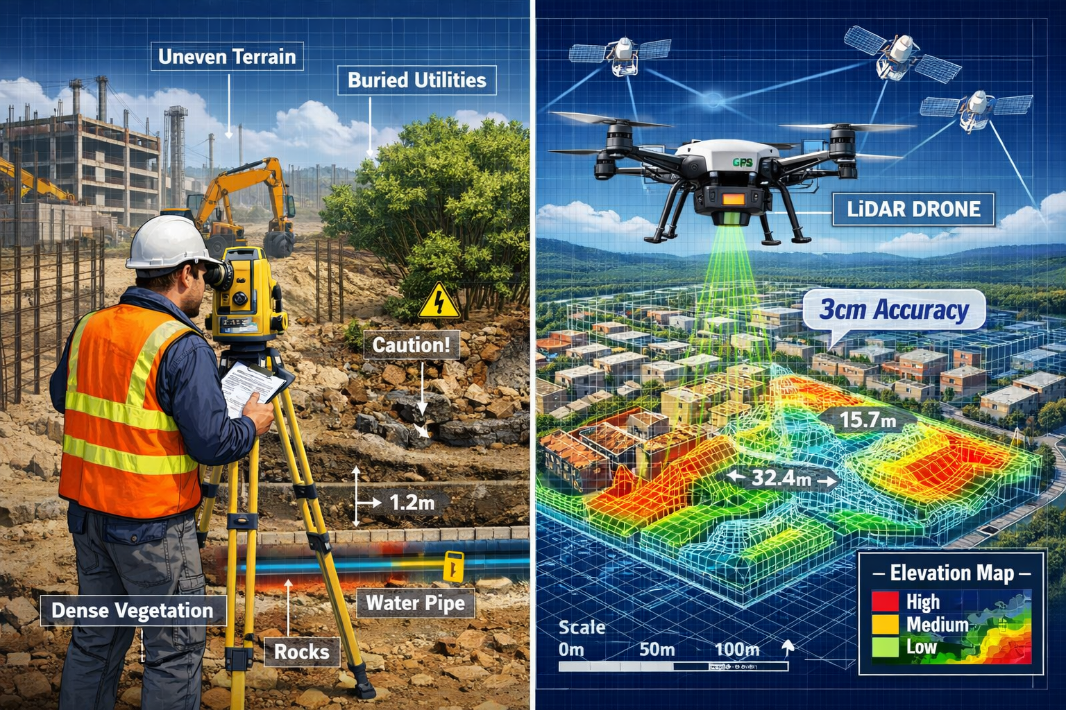
- Advanced surveying technologies including LiDAR, drone photogrammetry, and GNSS RTK systems now deliver accuracy within 3 cm (1/10 foot), enabling precise grading and construction verification for large-scale BTR communities[2]
- Cost savings of 30-40% are achievable by replacing traditional surveying methods with modern drone-based 3D mapping platforms, reducing the need for extensive on-site surveyor time[2]
- Topographic precision is critical for BTR developments to optimize site grading, minimize cut/fill costs, prevent drainage issues, and verify contractor billing accuracy
- Utility mapping challenges in master-planned communities require coordinated subsurface detection, GIS integration, and careful planning to avoid conflicts across multiple building phases
- Real-time monitoring and AI-powered analytics enable BTR developers to track progress in 90-day increments, identify issues before they become expensive change orders, and accelerate decision-making across multidisciplinary teams
Understanding the Build-to-Rent Market and Surveying Requirements
The BTR Boom Reshaping Residential Development
The build-to-rent sector has emerged as one of the fastest-growing segments in real estate development. Unlike traditional for-sale housing, BTR communities are purpose-built rental neighborhoods designed with long-term property management in mind. These master-planned developments typically feature dozens or even hundreds of units across multiple buildings, shared amenities, integrated infrastructure, and unified property management systems[3].
The appeal is clear: BTR communities offer residents modern, well-maintained housing without the commitment of homeownership, while providing investors with stable, predictable rental income streams. Developers are increasingly targeting suburban and exurban markets where land costs remain reasonable and demand for quality rental housing continues to grow[6].
This expansion creates unique surveying challenges that differ significantly from traditional residential subdivisions or commercial projects. BTR developments require:
- Large-scale topographic surveys covering 20-100+ acres
- Phased construction coordination across multiple building clusters
- Integrated utility planning for water, sewer, electrical, gas, and telecommunications
- Precise grading specifications to ensure proper drainage across the entire community
- Ongoing construction monitoring to verify compliance with master plans
Why Precision Matters More Than Ever
In BTR development, surveying precision directly impacts profitability. Consider these critical factors:
Grading accuracy determines cut/fill volumes that can represent hundreds of thousands of dollars in earthwork costs. Even small grading oversights can prove costly, as major BTR developer Treehouse Builders discovered before implementing advanced surveying platforms[2]. Modern surveying techniques now enable weekly 3D topographic scans accurate to 1/10 foot (3 cm), allowing developers to track dirt movement and verify contractor billing with unprecedented precision[2].
Foundation placement across multiple buildings must align perfectly with master plans to ensure proper spacing, setbacks, and infrastructure connections. A misplaced foundation can create domino effects requiring expensive corrections throughout the development.
Utility coordination becomes exponentially more complex in master-planned communities where underground infrastructure must serve dozens of buildings while avoiding conflicts with existing utilities, easements, and future expansion areas.
The financial implications are substantial. Understanding different types of surveys helps developers select appropriate surveying services for each project phase, from initial feasibility through final construction verification.
Surveying for Build-to-Rent Communities: Key Challenges
Challenge 1: Topographic Accuracy Across Large, Complex Sites 📐
Master-planned BTR communities present unique topographic surveying challenges that demand both precision and efficiency. Unlike smaller projects, these developments span vast areas with varying terrain conditions, existing features, and multiple elevation zones that must work together cohesively.
Scale and Complexity Factors:
The sheer size of BTR sites creates logistical challenges for traditional surveying methods. A 50-acre development might contain:
- Multiple elevation zones requiring precise grading transitions
- Existing vegetation and structures that obscure ground conditions
- Wetlands, streams, or other environmental features requiring careful documentation
- Varying soil conditions affecting foundation design
- Adjacent property boundaries requiring accurate demarcation
Traditional ground-based surveying would require weeks or months to capture comprehensive topographic data across such expanses. Survey crews must establish control points, navigate difficult terrain, and manually collect thousands of elevation measurements—a time-consuming and expensive process.
Drainage and Grading Precision:
Proper drainage design is absolutely critical in BTR communities. Water must flow away from buildings, through carefully designed swales and detention basins, and ultimately to approved discharge points. This requires topographic accuracy within inches to ensure:
- Positive drainage away from all building foundations
- Proper slope gradients (typically 2-5%) for surface water flow
- Accurate detention basin volumes for stormwater management
- Coordination between multiple building pads at different elevations
A survey error of just 0.5 feet in elevation can create standing water problems, foundation moisture issues, or inadequate stormwater capacity—all expensive to correct after construction.
Cut/Fill Optimization:
Earthwork represents one of the largest line items in BTR development budgets. The goal is to balance cut and fill volumes across the site, minimizing the need to import or export dirt. This requires:
- Detailed existing condition topographic surveys
- Proposed grading plans optimized for minimal earthwork
- Ongoing monitoring to track actual cut/fill quantities
- Verification of contractor-reported volumes
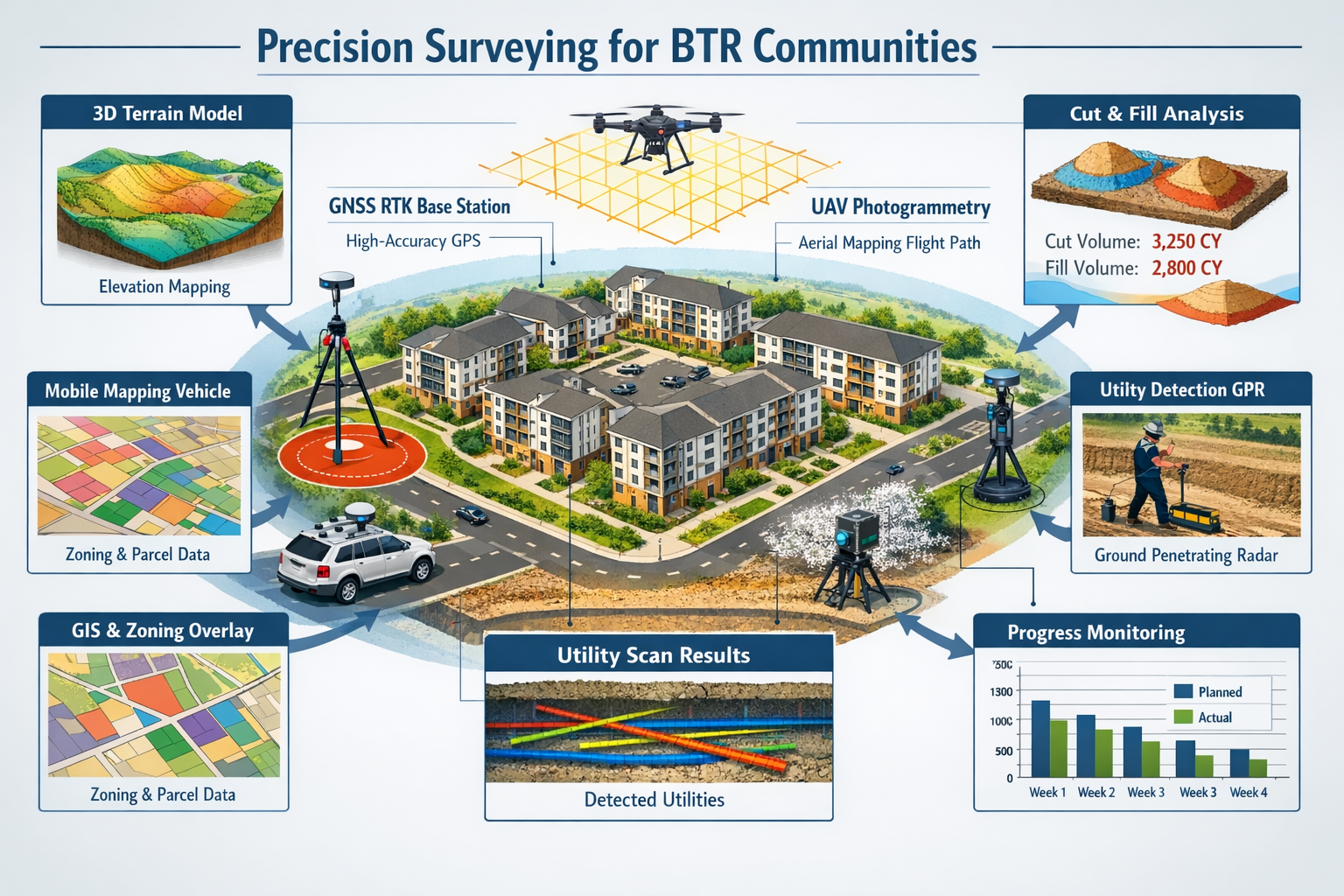
Treehouse Builders identified cut/fill tracking as a critical need, implementing TraceAir's quantity tracking and spoils generation tools to monitor dirt movement and verify contractor billing. For example, they can now confirm that the amount of dirt contractors claim to have exported matches actual site conditions, preventing billing discrepancies[2].
Challenge 2: Utility Mapping and Infrastructure Coordination 🔧
BTR communities require extensive underground infrastructure serving multiple buildings through interconnected systems. Accurate utility mapping is essential to avoid conflicts, prevent damage during construction, and enable future maintenance.
Subsurface Detection Challenges:
Unlike surface features easily captured by aerial surveying, underground utilities require specialized detection methods:
- Ground Penetrating Radar (GPR) to locate buried pipes, cables, and conduits
- Electromagnetic locators for metallic utilities
- Acoustic detection for pressurized water and gas lines
- Potholing and vacuum excavation to physically verify utility locations and depths
Existing utilities on or near BTR sites may include:
- Municipal water and sewer mains
- Electric transmission and distribution lines
- Natural gas pipelines
- Telecommunications infrastructure (fiber optic, cable, phone)
- Storm drainage systems
- Private utilities from adjacent developments
Each utility type may have different owners, easement requirements, and protection standards. Coordinating this information requires comprehensive stock condition surveys and detailed documentation.
GIS Integration for Multi-Layer Analysis:
Modern surveying workflows use Geographic Information Systems (GIS) to overlay multiple datasets in single maps for enhanced analysis and visualization[1]. For BTR developments, this means combining:
- Topographic survey data
- Existing utility locations and easements
- Zoning boundaries and setback requirements
- Environmental constraints (wetlands, protected areas)
- Proposed building locations and infrastructure routes
- Phasing plans for staged construction
GIS platforms enable developers to identify potential conflicts before construction begins, optimize infrastructure routing, and coordinate between multiple design disciplines.
Phased Construction Coordination:
Most BTR communities are built in phases over months or years. Utility surveying must account for:
- Stub-outs and connections for future phases
- Temporary utilities serving construction operations
- Permanent infrastructure sized for ultimate buildout
- As-built documentation after each phase for accurate records
Without precise utility mapping, future phases may encounter unexpected conflicts requiring expensive redesign and rework.
Challenge 3: Affordability-Driven Site Selection and Analysis 💰
BTR developers face intense pressure to control costs while delivering quality communities. Site selection significantly impacts project economics, and surveying plays a crucial role in evaluating potential locations.
Land Cost vs. Development Cost Trade-offs:
Affordable BTR development often requires sites in suburban or exurban locations where land costs are lower. However, these sites may present surveying and development challenges:
- Undeveloped or agricultural land requiring extensive clearing and grading
- Poor access necessitating new road construction
- Limited utility availability requiring extensions or new connections
- Topographic constraints increasing earthwork costs
- Environmental features requiring mitigation or avoidance
Comprehensive surveying during site due diligence helps developers accurately estimate development costs and identify potential deal-breakers before acquisition.
Regulatory and Zoning Analysis:
Surveying supports critical regulatory analysis including:
- Boundary surveys confirming legal descriptions and acreage
- Topographic surveys supporting drainage and environmental studies
- ALTA/NSPS surveys documenting easements, encroachments, and improvements
- Wetland delineation identifying regulated areas
- Floodplain mapping determining flood zone classifications
Understanding these factors early prevents costly surprises during permitting and design.
Comparative Site Analysis:
Developers often evaluate multiple potential sites simultaneously. Surveying enables data-driven comparison across candidates:
| Evaluation Factor | Site A | Site B | Site C |
|---|---|---|---|
| Topographic complexity | Moderate slopes | Steep terrain | Relatively flat |
| Estimated cut/fill volume | 15,000 CY | 35,000 CY | 8,000 CY |
| Utility availability | Water/sewer at boundary | 1,000' extension required | All utilities available |
| Environmental constraints | 2-acre wetland | None identified | 100-year floodplain (5 acres) |
| Survey-estimated development cost | $2.8M | $4.1M | $2.3M |
This analysis helps developers select sites that balance acquisition cost with development feasibility, optimizing overall project economics.
Surveying for Build-to-Rent Communities: Advanced Precision Techniques
Modern Technology Revolutionizing BTR Surveying
The surveying industry has undergone dramatic technological transformation, and BTR developers are among the primary beneficiaries. Advanced surveying technologies now deliver unprecedented accuracy, speed, and cost-efficiency compared to traditional methods.
LiDAR Mapping and 3D Laser Scanning 🛰️
Light Detection and Ranging (LiDAR) technology uses laser pulses to create highly accurate three-dimensional representations of terrain and structures. For BTR applications, LiDAR offers several advantages:
Accuracy and Density: Modern LiDAR systems capture millions of elevation points, creating dense "point clouds" with vertical accuracy of 3-5 cm. This density reveals subtle topographic features that traditional surveying might miss, including:
- Micro-drainage patterns affecting water flow
- Existing infrastructure remnants
- Vegetation height and density
- Building and structure details
Penetration Capabilities: Airborne LiDAR can penetrate vegetation canopy to capture ground elevations beneath trees and brush—critical for wooded BTR sites where ground visibility is limited.
Rapid Data Collection: LiDAR surveys can capture dozens of acres in hours rather than the days or weeks required for traditional ground surveys, accelerating project timelines and reducing costs.
3D Visualization: LiDAR point clouds create immersive 3D models that help stakeholders visualize existing conditions, proposed designs, and construction progress. These models support better decision-making across multidisciplinary teams.
Drone/UAV Photogrammetry ✈️
Unmanned Aerial Vehicles (UAVs) equipped with high-resolution cameras and LiDAR sensors have become increasingly accessible and cost-effective, enabling surveys of large areas and difficult terrain in shorter timeframes[1].
Drone-based surveying offers specific advantages for BTR developments:
Weekly Progress Monitoring: TraceAir Technologies delivers weekly 3D topographic scans for build-to-rent developers, enabling continuous monitoring of construction progress[2]. This frequent data collection supports:
- Real-time verification of grading operations
- Early detection of deviations from plans
- Documentation of construction sequencing
- Progress reporting to stakeholders and lenders
Cost Efficiency: Treehouse Builders achieved 30-40% cost savings by replacing previous surveying methods with modern drone-based 3D mapping platforms, reducing the need for on-site surveyors[2]. The cost benefits stem from:
- Reduced field time (hours vs. days)
- Smaller survey crews required
- Elimination of traffic control and safety measures for surveyors working in active construction zones
- Automated data processing reducing manual drafting time
Safety Improvements: Drones eliminate the need for surveyors to work in hazardous conditions such as steep slopes, active construction zones, or areas with heavy equipment operation.
Comprehensive Coverage: A single drone flight can capture an entire BTR site, ensuring no areas are missed and providing context for how individual features relate to the broader development.
For developers seeking comprehensive property analysis, RICS commercial building surveys provide detailed assessments that complement topographic surveying data.
GNSS RTK Systems 📡
Global Navigation Satellite System Real-Time Kinematic (GNSS RTK) technology provides centimeter-level positioning accuracy for surveying and machine control applications[1].
RTK systems work by:
- Establishing a base station at a known location on the project site
- Transmitting correction signals to rover units used by surveyors or mounted on construction equipment
- Achieving horizontal accuracy of 1-2 cm and vertical accuracy of 2-3 cm
For BTR developments, GNSS RTK enables:
Machine Control Integration: Excavators, graders, and dozers equipped with RTK receivers can automatically grade to design elevations, reducing over-excavation and improving accuracy.
Rapid Layout: Building corners, utility locations, and other features can be staked quickly and accurately, accelerating construction sequencing.
As-Built Verification: Completed work can be surveyed efficiently to verify compliance with plans and create accurate as-built documentation.
Continuous Operation: Unlike traditional surveying requiring line-of-sight between instrument and target, GNSS RTK works in most weather conditions and doesn't require visual contact between base and rover (though satellite visibility is necessary).
Mobile Mapping Systems 🚗
Mobile mapping vehicles equipped with LiDAR scanners, cameras, and positioning systems can rapidly collect data along roads and corridors. For BTR communities, mobile mapping supports:
- Utility corridor surveys along streets and easements
- As-built documentation of completed infrastructure
- Existing condition surveys of adjacent roads and utilities
- Progress monitoring of linear features like streets and sidewalks
Mobile mapping is particularly valuable for large master-planned communities where miles of internal streets and utilities must be documented.
AI and Real-Time Data Processing
Artificial intelligence is transforming how surveying data is processed and analyzed. In 2026, AI-driven tools are reducing the time needed to analyze surveying data and can monitor changes in terrain and structures over time for construction monitoring[1].
Automated Change Detection
AI algorithms can compare sequential surveys to automatically identify:
- Earthwork progress: Quantifying cut/fill volumes between survey dates
- Construction deviations: Detecting differences between design models and as-built conditions
- Erosion or settlement: Identifying unexpected terrain changes
- Encroachments: Detecting unauthorized work or equipment placement
This automation eliminates hours of manual comparison work and ensures no changes go unnoticed.
Predictive Analytics
Emerging AI applications include predictive risk modeling to forecast potential issues such as flooding or landslides using historical data[1]. For BTR developments, predictive tools might identify:
- Areas prone to drainage problems based on topography and soil conditions
- Optimal grading strategies minimizing earthwork costs
- Utility routing that avoids future conflicts
- Construction sequencing that minimizes weather-related delays
While these tools remain in early development stages, they represent the future of data-driven development decision-making.
360-Degree Panoramic Visualization
Current BTR surveying platforms incorporate 360-degree panoramas to help teams immerse themselves in project sites during meetings, accelerating decision-making and alignment across multidisciplinary teams[2].
These immersive visualizations enable:
- Remote site visits for stakeholders unable to travel to the location
- Historical documentation showing site conditions at specific dates
- Issue resolution by reviewing actual site conditions during design meetings
- Marketing materials showcasing development progress to investors and future residents
When combined with 3D topographic models, 360-degree imagery creates powerful tools for project communication and coordination.
Implementing Precision Surveying in BTR Projects
Establishing Survey Control and Standards
Successful BTR surveying begins with establishing robust control networks and clear accuracy standards that guide all subsequent work.
Project Control Networks
A control network consists of precisely surveyed reference points distributed across the project site. These control points serve as the foundation for all surveying and construction layout work.
Best practices for BTR control networks include:
- Density: Establish control points approximately every 500-1,000 feet across the site
- Permanence: Use durable monuments (concrete-encased iron rods, brass caps) that will survive construction activities
- Redundancy: Include more control points than minimally necessary to provide backup if some are destroyed
- Vertical control: Establish benchmarks tied to established datums (NAVD88) for elevation reference
- Documentation: Create detailed control point descriptions, coordinates, and photographs for easy relocation
Accuracy Specifications
Different project elements require different accuracy levels. Typical BTR specifications might include:
| Survey Type | Horizontal Accuracy | Vertical Accuracy | Application |
|---|---|---|---|
| Boundary survey | ±0.02 ft | N/A | Property lines, easements |
| Topographic survey | ±0.1 ft | ±0.05 ft | Grading design, drainage analysis |
| Construction layout | ±0.02 ft | ±0.01 ft | Building foundations, utilities |
| As-built survey | ±0.1 ft | ±0.05 ft | Final documentation |
These specifications should be clearly defined in project contracts and consistently enforced throughout development.
Understanding survey pricing helps developers budget appropriately for the level of accuracy their projects require.
Phased Surveying Strategies
BTR communities typically develop in phases over extended periods. Strategic surveying approaches must account for this phased construction while maintaining consistency across the entire project.
Pre-Development Phase
Initial surveying establishes baseline conditions and supports design development:
- Boundary and topographic surveys defining property limits and existing conditions
- Utility location surveys identifying existing infrastructure
- Environmental surveys documenting wetlands, floodplains, and protected features
- Geotechnical investigation support locating boring and test pit locations
This phase creates the foundation for all subsequent design and permitting work.
Design Phase Support
As design progresses, surveying provides critical information:
- Additional topographic detail in specific areas requiring refined design
- Cross-sections along proposed roads and utilities
- Utility coordination surveys verifying conflicts and clearances
- Easement exhibits supporting legal descriptions and agreements
Designers rely on survey accuracy to create constructible plans that minimize field changes.
Construction Phase Monitoring
Active construction requires ongoing surveying support:
- Weekly or bi-weekly progress surveys tracking earthwork and construction advancement[2]
- Grade verification ensuring compliance with design elevations
- Utility location verification before excavation (call-before-you-dig coordination)
- Foundation and building layout for precise placement
- As-built surveys documenting completed work
Treehouse Builders uses 90-day increment comparisons combining aerial imagery with quantitative data for comprehensive progress verification and stakeholder reporting[2]. This regular monitoring enables:
- Early identification of issues before they escalate
- Accurate progress billing verification
- Documentation for lender draw requests
- Historical records for future reference
Post-Construction Documentation
Final surveying creates permanent records:
- As-built surveys showing actual locations of buildings, utilities, and improvements
- Final plats for recording with local authorities
- Property line verification confirming compliance with setbacks and easements
- Maintenance documentation supporting ongoing property management
These final surveys become critical references for property management, future expansion, and potential property sales.
Overlay and Comparison Tools
Modern surveying platforms provide powerful overlay and comparison capabilities that revolutionize project management for BTR developers.
Design vs. As-Built Comparison
BTR development teams now use overlay and measuring tools to compare project plans against onsite conditions in real-time, identifying issues early before they escalate into expensive change orders[2].
This capability enables:
Immediate deviation detection: Overlaying design models on current survey data instantly reveals areas where construction deviates from plans, whether due to grading errors, misplaced utilities, or unauthorized changes.
Quantitative analysis: Measuring tools calculate exact deviations, supporting decisions about whether corrections are necessary or design adjustments are more practical.
Change order verification: When contractors request change orders claiming unforeseen conditions, overlay analysis can verify whether conditions truly differ from design assumptions or whether the contractor failed to follow plans.
Proactive problem-solving: Early detection enables corrections while equipment is still on-site and before subsequent work compounds the problem.
For complex projects, structural surveys provide detailed analysis of building conditions that complement topographic surveying data.
Historical Progress Tracking
Maintaining a library of sequential surveys creates valuable historical records showing development evolution. Benefits include:
- Timeline documentation for project management and stakeholder communication
- Dispute resolution providing objective evidence of conditions at specific dates
- Lessons learned analysis comparing planned vs. actual construction sequences
- Marketing materials showing transformation from raw land to completed community
Multi-Discipline Coordination
Overlay tools enable coordination between multiple design disciplines:
- Civil and architectural alignment: Verifying building pad elevations match architectural floor elevations
- Utility and structural coordination: Ensuring underground utilities don't conflict with building foundations
- Landscape and drainage integration: Confirming landscape grading supports drainage design
- Traffic and site access: Validating construction access routes and permanent circulation patterns
This coordination prevents the costly conflicts that arise when disciplines work in isolation.
Cost-Benefit Analysis of Modern Surveying Technologies
Quantifying ROI for BTR Developers
Investing in advanced surveying technologies requires upfront costs, but the return on investment for BTR developers can be substantial.
Direct Cost Savings
Treehouse Builders' experience demonstrates tangible cost benefits:
30-40% surveying cost reduction by replacing traditional methods with drone-based platforms[2]. For a typical BTR development requiring $100,000 in traditional surveying services, this represents $30,000-$40,000 in direct savings.
Reduced change orders: Early issue detection through regular monitoring prevents expensive corrections. Industry data suggests change orders typically add 5-10% to construction costs. Reducing change orders by even 25% through better surveying can save $125,000-$250,000 on a $10 million project.
Earthwork optimization: Accurate cut/fill tracking and verification prevents over-excavation and billing errors. On projects moving 50,000 cubic yards of dirt at $15/CY, preventing just 5% over-excavation saves $37,500.
Utility conflict avoidance: Preventing a single major utility conflict (requiring redesign, delays, and reconstruction) can save $50,000-$200,000+ depending on severity.
Indirect Benefits
Beyond direct cost savings, modern surveying delivers valuable indirect benefits:
Accelerated timelines: Faster surveying reduces project schedules, enabling earlier revenue generation and reduced carrying costs. Shortening a 12-month construction schedule by just two weeks can save $50,000-$100,000 in financing costs on a $10 million project.
Improved decision-making: Better data supports more informed decisions throughout development, reducing costly mistakes and optimizing designs.
Enhanced stakeholder communication: Visual 3D models and progress documentation improve communication with investors, lenders, municipalities, and future residents, building confidence and facilitating approvals.
Risk mitigation: Comprehensive surveying reduces the risk of legal disputes, regulatory violations, and construction failures that could result in litigation or project delays.
Competitive advantage: Developers who leverage advanced surveying can deliver projects faster, more accurately, and more profitably, positioning them to win future opportunities.
Technology Investment Considerations
Implementing advanced surveying technologies requires careful planning:
In-House vs. Outsourced
BTR developers must decide whether to:
Build in-house capabilities:
- Pros: Direct control, immediate availability, proprietary knowledge
- Cons: Equipment investment ($50,000-$200,000+), staff training, technology obsolescence risk
- Best for: Large developers with continuous project pipelines
Outsource to specialized providers:
- Pros: No capital investment, access to latest technology, scalable based on project needs
- Cons: Less control over scheduling, potential communication challenges
- Best for: Smaller developers or those with intermittent projects
Many developers adopt a hybrid approach, maintaining basic surveying capabilities in-house while outsourcing specialized services like LiDAR or weekly drone monitoring.
Platform Selection Criteria
When evaluating surveying technology platforms, consider:
- Accuracy specifications: Does the platform meet project requirements?
- Data processing capabilities: How quickly can data be processed and delivered?
- Integration capabilities: Does it work with existing design and project management software?
- User interface: Can team members easily access and interpret data?
- Support and training: What training and ongoing support does the provider offer?
- Scalability: Can the platform handle projects of varying sizes?
- Cost structure: Subscription vs. per-project pricing, minimum commitments
Platforms like TraceAir have proven successful for BTR developers by offering comprehensive capabilities specifically tailored to construction monitoring and progress tracking[2].
Best Practices and Recommendations
Establishing Surveying Protocols
Successful BTR developers establish clear surveying protocols that ensure consistency across projects and phases:
Documentation Standards
Create standardized templates and requirements for:
- Survey deliverable formats (CAD file standards, coordinate systems, layer naming conventions)
- Report content and organization (cover sheets, certifications, notes, legends)
- Accuracy certifications (required statements, professional seals)
- Data archiving (file naming, version control, backup procedures)
Consistent documentation enables team members to quickly find information and reduces confusion when multiple surveyors work on different project phases.
Quality Control Procedures
Implement quality control processes including:
- Independent verification of critical measurements (property corners, building foundations)
- Closure checks on traverse loops and level circuits
- Redundant measurements of key features
- Peer review of survey calculations and deliverables
- Field verification of processed data against actual conditions
Quality control catches errors before they impact construction, preventing costly corrections.
For projects requiring detailed condition assessment, schedule of condition reporting provides comprehensive documentation that complements surveying data.
Communication Protocols
Establish clear communication procedures:
- Regular coordination meetings between surveyors, designers, and contractors
- Issue escalation procedures for identified problems requiring immediate attention
- Progress reporting schedules aligned with project milestones and stakeholder needs
- Data sharing platforms providing team access to current survey information
Effective communication ensures survey data informs decision-making throughout the project.
Selecting Qualified Surveying Partners
The surveying firm you select significantly impacts project success. Key selection criteria include:
Professional Qualifications
Verify that surveyors hold:
- Professional licensure in the project state (Professional Land Surveyor or equivalent)
- Professional liability insurance adequate for project size and complexity
- Technology certifications for specialized equipment (drone pilot licenses, LiDAR certifications)
- Professional organization membership (NSPS, state surveying associations)
Working with RICS building surveyors ensures professional standards and accountability.
Relevant Experience
Prioritize firms with:
- BTR or multi-family development experience demonstrating understanding of unique requirements
- Local knowledge of regulations, permitting requirements, and typical site conditions
- Technology capabilities matching project needs
- References from similar projects demonstrating successful performance
Collaborative Approach
Select surveyors who demonstrate:
- Proactive communication identifying potential issues before they become problems
- Flexibility adapting to changing project needs and schedules
- Problem-solving orientation proposing solutions rather than just identifying problems
- Integration mindset working collaboratively with other project team members
The best surveying relationships are true partnerships where surveyors function as valued team members contributing to project success.
Future-Proofing BTR Surveying Strategies
As technology continues evolving, forward-thinking developers should:
Stay Informed on Emerging Technologies
Monitor developments in:
- Autonomous surveying systems using robotic total stations and autonomous drones
- AI-powered analysis tools automating data interpretation and issue detection
- Augmented reality applications overlaying design models on real-world views
- Blockchain documentation creating immutable records of survey data
- Integrated digital twins combining surveying data with BIM models for comprehensive project visualization
Early adoption of proven technologies can provide competitive advantages.
Build Flexible Technology Infrastructure
Invest in:
- Open data standards ensuring compatibility as technologies evolve
- Cloud-based platforms providing accessibility and scalability
- API integrations connecting surveying data with other project systems
- Training programs ensuring team members can leverage new capabilities
Flexible infrastructure prevents technology lock-in and enables adaptation as better solutions emerge.
Cultivate Technology Partnerships
Develop relationships with:
- Technology providers offering early access to new capabilities
- Academic institutions researching surveying innovations
- Industry organizations sharing best practices and emerging trends
- Peer developers learning from others' experiences
These partnerships provide insights into where technology is heading and how to best leverage innovations.
Conclusion: Precision as the Foundation of BTR Success

Surveying for Build-to-Rent Communities: Challenges and Precision Techniques represents far more than technical measurement—it forms the essential foundation upon which successful master-planned neighborhoods are built. In 2026, the convergence of advanced technologies including LiDAR mapping, drone photogrammetry, GNSS RTK systems, and AI-powered analytics has transformed surveying from a periodic necessity into a continuous strategic advantage.
The challenges facing BTR developers—topographic accuracy across vast sites, complex utility coordination, and affordability-driven site selection—demand precision techniques that traditional surveying methods simply cannot deliver efficiently. Modern platforms now provide weekly 3D scans accurate to 3 cm, enabling real-time monitoring, cut/fill verification, and early issue detection that prevent expensive change orders[2].
The financial case is compelling: developers like Treehouse Builders have achieved 30-40% cost savings while simultaneously improving accuracy and accelerating timelines[2]. These benefits compound across project phases, from informed site selection through final as-built documentation, creating competitive advantages that directly impact profitability.
Actionable Next Steps
For BTR developers looking to optimize their surveying strategies:
- Evaluate current surveying approaches against modern capabilities, identifying gaps and opportunities for improvement
- Research technology platforms specifically designed for construction monitoring and BTR development, requesting demonstrations and case studies
- Pilot advanced techniques on a single project phase to quantify benefits before full-scale implementation
- Establish surveying protocols standardizing documentation, quality control, and communication procedures
- Build strategic partnerships with qualified surveying firms offering relevant experience and technology capabilities
- Invest in team training ensuring project managers and field personnel can effectively leverage surveying data
- Monitor emerging technologies staying informed about innovations that could provide future competitive advantages
The BTR market shows no signs of slowing, and developers who master precision surveying techniques will be best positioned to deliver projects on time, on budget, and with the quality that attracts long-term residents and investors. The foundation of success—literally and figuratively—begins with accurate, comprehensive surveying that transforms raw land into thriving communities.
By embracing the challenges and implementing the precision techniques outlined in this guide, BTR developers can navigate the complexities of master-planned community development with confidence, turning surveying from a cost center into a strategic investment that pays dividends throughout the project lifecycle and beyond.
References
[1] The Future Of Land Surveying Technology And Upcoming Trends In 2026 – https://metricop.com/blogs/land-surveying/the-future-of-land-surveying-technology-and-upcoming-trends-in-2026
[2] How Treehouse Builders Accelerates Build To Rent Development With Traceair – https://www.traceair.net/whats-new/how-treehouse-builders-accelerates-build-to-rent-development-with-traceair
[3] Build To Rent Homes – https://www.nar.realtor/magazine/real-estate-news/commercial/build-to-rent-homes
[6] Real Estate Trends 2026 – https://www.avidxchange.com/blog/real-estate-trends-2026/