The land surveying profession stands at a transformative crossroads in 2026. What once required weeks of manual data processing, multiple site visits, and painstaking analysis can now be accomplished in hours—or even minutes. AI and Machine Learning in Land Surveying: Predicting Risks and Automating Analysis has evolved from an experimental concept into an operational reality that's reshaping how surveyors work, what they deliver, and the value they provide to clients across construction, infrastructure, mining, and development sectors.
Modern surveying operations now leverage artificial intelligence to instantly classify terrain, identify survey markers, flag anomalies, and generate preliminary surface models without human intervention.[1] This isn't futuristic speculation—it's the current state of the industry. Machine learning algorithms process massive datasets from LiDAR scans, drone imagery, and GNSS observations to detect subtle changes in land formations, predict geological risks like landslides and subsidence, and automate workflows that previously consumed countless hours of professional time.
Key Takeaways
- ⚡ Processing speed has increased exponentially: Post-processing timelines have decreased from weeks to hours or minutes, with AI automatically detecting assets, defects, and anomalies while classifying terrain with greater consistency than manual methods.[5]
- 🎯 Predictive risk modeling is now operational: AI systems actively predict geological changes, land deformations, soil erosion, landslides, and ground subsidence by analyzing historical survey data combined with environmental factors.[2]
- 🚁 Autonomous drone capabilities reduce field visits: What used to require multiple site visits can now be captured in a single, highly detailed autonomous flight with multi-sensor drones providing unprecedented clarity and detail.[1]
- 📊 Industry adoption is accelerating rapidly: 94% of surveying and construction professionals surveyed indicated they will increase AI usage in 2026, reflecting sector-wide momentum.[6]
- 🔧 Machine learning eliminates repetitive analysis: ML algorithms automatically classify terrain and land-use, forecast soil movement and building settlement, and identify outliers in GNSS observations instantly.[4]
Understanding AI and Machine Learning in Land Surveying: Predicting Risks and Automating Analysis

The Technology Foundation
Artificial intelligence and machine learning represent fundamentally different approaches to data processing compared to traditional surveying methods. Where conventional workflows require human surveyors to manually interpret data, classify features, and identify patterns, AI systems learn from vast datasets to recognize patterns automatically.
Machine learning specifically refers to algorithms that improve their performance through exposure to data without being explicitly programmed for every scenario. In surveying contexts, this means software that can:
- Distinguish between vegetation, buildings, and terrain features within LiDAR point clouds
- Identify survey markers and control points across thousands of images
- Detect anomalies and outliers in GNSS observations
- Classify land use and terrain types based on spectral signatures
- Predict future conditions based on historical patterns
The practical impact becomes clear when examining real-world applications. Traditional RICS building surveys required extensive manual inspection and documentation. Today's AI-enhanced surveys can automatically identify structural features, flag potential defects, and generate preliminary reports that surveyors then verify and refine.
From Data Collection to Intelligent Analysis
The surveying workflow has traditionally followed a linear path: collect data in the field, process it in the office, analyze results, and produce deliverables. AI and Machine Learning in Land Surveying: Predicting Risks and Automating Analysis transforms this into an integrated, intelligent system where analysis begins during data collection itself.
Modern autonomous drones equipped with AI capabilities can:
✅ Plan optimal flight paths using predictive modeling based on terrain and project requirements
✅ Adjust altitude, angle, and sensor selection in real-time to achieve optimal readings
✅ Identify areas requiring additional coverage during the flight
✅ Begin preliminary processing while still airborne
✅ Flag potential issues for surveyor review immediately upon landing[1]
This represents a fundamental shift from reactive to proactive surveying. Rather than discovering problems during post-processing, AI systems identify issues during data collection when they can still be addressed efficiently.
How AI Processes Massive Datasets in Modern Surveying
The Scale of Modern Survey Data
A single drone flight over a moderate-sized commercial property can generate hundreds of gigabytes of data: thousands of high-resolution images, millions of LiDAR points, multispectral readings, and precise GNSS coordinates. Processing this volume manually would be impractical, yet AI systems handle it routinely.
Consider the data volume comparison:
| Survey Method | Data Volume (per hectare) | Processing Time (Traditional) | Processing Time (AI-Enhanced) |
|---|---|---|---|
| Traditional Total Station | 500 MB – 2 GB | 2-4 days | 4-8 hours |
| Drone Photogrammetry | 10-50 GB | 1-2 weeks | 2-6 hours |
| LiDAR Scanning | 50-200 GB | 2-4 weeks | 30 minutes – 4 hours |
| Multi-Sensor Autonomous | 100-500 GB | 4-8 weeks | 1-8 hours |
The dramatic reduction in processing time doesn't come from faster computers alone—it results from intelligent algorithms that know what to look for and what to ignore. AI systems trained on millions of previous surveys can instantly recognize features that would take human analysts hours to identify.[5]
Automated Feature Recognition and Classification
One of the most powerful applications of AI and Machine Learning in Land Surveying: Predicting Risks and Automating Analysis involves automated feature recognition. Modern systems can process LiDAR point clouds to automatically:
🌳 Separate vegetation from ground surface with 95%+ accuracy
🏢 Identify and classify building structures including roofs, walls, and architectural features
🚗 Recognize infrastructure elements like roads, bridges, power lines, and utilities
🌊 Detect water bodies and drainage features critical for flood risk assessment
⛰️ Map terrain features including slopes, ridges, valleys, and geological formations
This automated classification dramatically accelerates the creation of detailed topographic models. What previously required days of manual point cloud editing can now be accomplished in minutes, allowing surveyors to focus on verification, analysis, and client consultation rather than repetitive data processing.
For specialized applications like stock condition surveys, AI-enhanced analysis can automatically identify building elements, assess their condition based on visual indicators, and flag areas requiring detailed inspection—streamlining the entire assessment process.
Real-Time Anomaly Detection
Perhaps the most valuable capability AI brings to surveying is instant anomaly detection. Machine learning algorithms trained on thousands of surveys develop an understanding of what "normal" looks like for various property types, terrain conditions, and survey scenarios.
When processing new data, these systems immediately flag:
- Unexpected elevation changes that might indicate ground movement or subsidence
- Structural irregularities suggesting potential defects or damage
- Vegetation encroachment on boundaries or infrastructure
- Drainage issues based on water pooling patterns
- Measurement inconsistencies requiring field verification
This capability proves particularly valuable for subsidence surveys, where detecting subtle ground movements early can prevent catastrophic structural damage. AI systems can compare current survey data against historical baselines to identify millimeter-level changes that human analysts might miss.
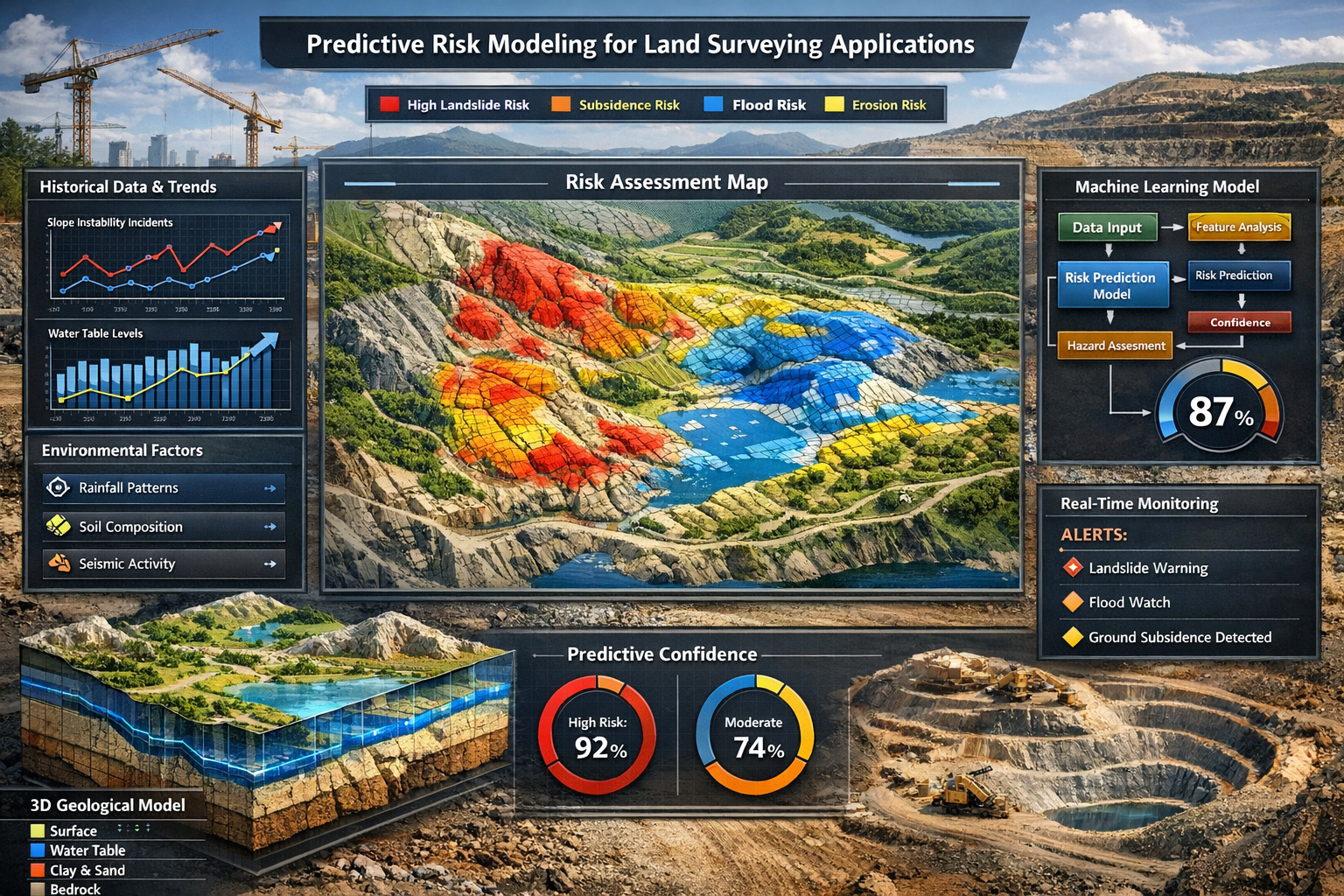
Predictive Risk Modeling: From Mapping to Forecasting
The Evolution Beyond Traditional Surveying
Traditional land surveying focused primarily on documenting current conditions: measuring boundaries, mapping topography, and recording existing features. While this remains essential, AI and Machine Learning in Land Surveying: Predicting Risks and Automating Analysis extends the surveyor's role into predictive analysis and risk forecasting.[2]
Modern AI systems don't just map what exists—they predict what's likely to happen. By analyzing historical survey data combined with environmental factors, machine learning algorithms can forecast:
🌧️ Flood risk zones based on topography, drainage patterns, soil permeability, and rainfall data
⛰️ Landslide probability considering slope angles, soil composition, vegetation cover, and seismic activity
🏗️ Ground subsidence potential analyzing soil types, groundwater levels, and nearby excavation
🌊 Erosion patterns predicting where and how quickly land loss will occur
🏢 Building settlement forecasting foundation movement based on soil conditions and loading
This predictive capability transforms surveying from a reactive service (measuring problems after they occur) to a proactive risk management tool that helps clients avoid costly issues before they develop.
Geological Change Prediction in Practice
The practical applications of predictive risk modeling are already visible across multiple sectors in 2026. Consider these real-world scenarios:
Construction and Development: Before breaking ground on a major commercial development, AI-enhanced surveys analyze soil composition, groundwater patterns, historical settlement data from nearby structures, and geological formations to predict foundation requirements and identify potential stability issues. This information directly informs commercial building surveys and project planning decisions.
Infrastructure Planning: Transportation agencies use predictive models to identify road sections at high risk for subsidence or erosion, prioritizing maintenance and reconstruction budgets based on AI-generated risk scores rather than reactive repairs after failures occur.
Mining Operations: AI systems continuously analyze survey data from active mining sites to predict ground movement, identify areas at risk for collapse, and optimize extraction patterns to minimize geological instability.[2]
Agricultural Land Management: Predictive models identify areas best suited for specific crops based on soil health indicators, drainage patterns, and climate data—information that extends far beyond traditional boundary surveys to provide genuine agricultural planning value.
Environmental Factor Integration
What makes modern predictive modeling particularly powerful is its ability to integrate diverse data sources beyond traditional survey measurements. AI systems combine:
- Historical survey data showing how land has changed over time
- Soil composition analysis from geotechnical testing
- Rainfall and weather patterns from meteorological databases
- Seismic activity records indicating geological instability
- Groundwater level monitoring tracking subsurface water movement
- Vegetation health indices from multispectral imaging
- Human activity data including construction, excavation, and land use changes
By processing these diverse inputs simultaneously, machine learning algorithms identify complex relationships that would be impossible for human analysts to recognize. For example, an AI system might identify that a specific combination of soil type, slope angle, rainfall intensity, and vegetation loss creates high landslide risk—even when each factor individually appears within acceptable ranges.[2]
This comprehensive analysis proves particularly valuable for specialized assessments like specific defect reports, where understanding the underlying causes of visible problems requires integrating multiple data sources.
Automating Surveying Workflows with Machine Learning
From Manual Processes to Intelligent Automation
The surveying profession has historically been labor-intensive, requiring skilled professionals to perform repetitive tasks: measuring control points, processing observations, classifying features, checking for errors, and generating deliverables. AI and Machine Learning in Land Surveying: Predicting Risks and Automating Analysis automates these repetitive elements while preserving professional judgment where it matters most.
Modern automated workflows handle:
Data Processing Automation:
- Automatic point cloud cleaning and classification
- Batch processing of drone imagery into orthomosaics
- Automated generation of contour lines and surface models
- Instant coordinate transformations and datum conversions
- Automatic quality checking and error flagging
Analysis Automation:
- Terrain classification (slopes, aspects, elevations)
- Vegetation identification and height measurement
- Building footprint extraction and volume calculation
- Boundary line detection and verification
- Change detection between survey periods
Deliverable Generation:
- Automated CAD drawing creation from point clouds
- Report generation with standard sections pre-populated
- 3D model creation for BIM integration
- Custom output formatting for specific client requirements
The time savings are substantial. Post-processing timelines that previously required weeks now complete in hours or minutes, allowing surveyors to handle larger project volumes or dedicate more time to client consultation and complex analysis.[5]
Autonomous Drone Operations
Perhaps the most visible manifestation of surveying automation involves autonomous drone systems that plan and execute survey missions with minimal human intervention. In 2026, advanced drone platforms can:
📱 Accept project parameters (area to survey, required accuracy, deliverable specifications)
🗺️ Plan optimal flight paths considering terrain, obstacles, weather, and regulatory restrictions
🚁 Execute missions autonomously with real-time adjustments for wind, lighting, and obstacles
📊 Process data during flight to identify coverage gaps requiring additional passes
✅ Verify data quality before landing to ensure mission success
📦 Deliver preliminary results within minutes of landing[1]
This automation dramatically reduces the expertise required for basic data collection, though professional surveyors remain essential for mission planning, quality verification, and data interpretation. What used to require multiple site visits with specialized equipment can now be captured in a single autonomous flight with multi-sensor drones providing clarity and detail not possible a decade ago.[1]
For large-scale projects like commercial property surveying, autonomous systems can survey entire developments in hours rather than days, providing up-to-date information for project management and progress monitoring.
Machine Learning Pattern Recognition
Beyond automating individual tasks, machine learning excels at identifying patterns across large datasets that inform surveying decisions. AI systems trained on thousands of surveys can:
🎯 Recognize optimal control point placement for specific terrain types
📏 Identify systematic errors in measurement equipment before they affect deliverables
🌍 Predict GNSS accuracy based on atmospheric conditions, satellite geometry, and local interference
🏗️ Classify construction progress by comparing sequential surveys against project plans
🌱 Track vegetation growth patterns relevant for boundary maintenance and visibility
This pattern recognition capability proves particularly valuable for quality control. Rather than relying on manual checks that might miss subtle issues, AI systems continuously monitor data for inconsistencies, outliers, and anomalies—flagging potential problems immediately for surveyor review.[4]
The technology also supports predictive equipment maintenance, with AI-powered lifecycle management monitoring instrument performance in real-time to identify potential failures before they occur, minimizing downtime and reducing replacement costs.[2]
Real-World Implementation Examples from 2026
Infrastructure Monitoring and Maintenance
Transportation agencies across multiple countries have implemented AI-enhanced surveying systems for continuous infrastructure monitoring. These systems combine:
- Permanent monitoring stations with automated total stations and GNSS receivers
- Regular drone surveys conducted monthly or quarterly
- Mobile mapping systems on maintenance vehicles
- AI analysis platforms processing all data streams simultaneously
The AI systems detect millimeter-level changes in bridge structures, identify pavement deterioration patterns, predict maintenance requirements, and prioritize repair budgets based on risk scores. One major highway authority reported that predictive maintenance enabled by AI surveying reduced emergency repairs by 67% while extending average pavement life by 23%.[2]
Urban Development and Smart Cities
Municipal planning departments increasingly rely on AI and Machine Learning in Land Surveying: Predicting Risks and Automating Analysis for comprehensive urban modeling. High-resolution survey data creates accurate digital twins of entire cities, integrated into Building Information Modeling (BIM) systems that enable:
- Simulation of new developments and their impact on existing infrastructure
- Traffic pattern evaluation based on terrain and building configurations
- Drainage system analysis predicting flood risks under various rainfall scenarios
- Solar potential mapping identifying optimal locations for renewable energy installations
- Urban heat island assessment informing green space planning[2]
These digital city models provide planning authorities with unprecedented analytical capabilities, supporting evidence-based decision-making for sustainable urban development.
Mining and Resource Extraction
The mining industry has embraced AI surveying for both operational efficiency and safety. Modern mining operations use:
- Continuous automated surveys of pit walls and underground workings
- Predictive stability analysis identifying collapse risks before they become critical
- Volume calculations for production tracking and inventory management
- Autonomous haul truck navigation based on real-time survey data
- Rehabilitation planning using predictive models for post-mining land use
One major mining company reported that AI-enhanced surveying reduced geotechnical incidents by 82% while improving extraction efficiency by 15% through optimized blast planning based on detailed geological models.[2]
Agricultural Land Management
Agricultural applications of AI surveying extend beyond simple boundary determination to comprehensive land management support:
- Soil health mapping using multispectral analysis combined with topographic data
- Drainage optimization identifying areas requiring tile drainage or grading
- Irrigation planning based on precise elevation models and soil moisture patterns
- Crop suitability analysis matching land characteristics to optimal crop types
- Yield prediction correlating topography and soil conditions with historical production data
Farmers using AI-enhanced survey data reported average yield increases of 8-12% through optimized land use and targeted interventions based on precise spatial analysis.[2]
The Professional Surveyor's Evolving Role
From Data Collector to Strategic Advisor
The automation of routine surveying tasks doesn't diminish the professional surveyor's role—it elevates it. As AI handles repetitive data processing and basic analysis, surveyors increasingly focus on:
Strategic Consultation: Helping clients understand what survey data means for their specific objectives, whether that involves development planning, risk assessment, or regulatory compliance.
Complex Problem Solving: Addressing unusual situations, challenging terrain, or unique project requirements that demand professional judgment beyond algorithmic capabilities.
Quality Assurance: Verifying AI-generated results, identifying edge cases where automated analysis may be unreliable, and ensuring deliverables meet professional standards.
Technology Management: Selecting appropriate AI tools for specific applications, training systems on project-specific requirements, and integrating multiple data sources effectively.
Regulatory Navigation: Ensuring AI-enhanced surveys meet legal requirements, professional standards, and client specifications—particularly important for RICS home surveys and other regulated applications.
Skills Development for the AI Era
Professional surveyors working effectively with AI and Machine Learning in Land Surveying: Predicting Risks and Automating Analysis require new competencies beyond traditional surveying skills:[4]
📚 Data Science Fundamentals: Understanding how machine learning algorithms work, their limitations, and appropriate applications
💻 Programming Basics: Ability to customize AI tools, automate workflows, and integrate systems
🔍 Critical Analysis: Evaluating AI-generated results for accuracy, identifying when automated analysis may be unreliable
🎓 Continuous Learning: Staying current with rapidly evolving AI capabilities and industry applications
🤝 Interdisciplinary Collaboration: Working effectively with data scientists, software developers, and domain experts
The surveying profession entered 2026 amid accelerating digital transformation, driven by pressure to deliver faster, more accurate results with AI and machine learning as foundational technologies.[7] Professionals who embrace these tools while maintaining rigorous quality standards position themselves for success in this evolving landscape.
Maintaining Professional Standards
Despite increasing automation, professional standards remain paramount. Organizations like RICS continue to emphasize that AI tools must enhance—not replace—professional judgment. Key principles include:
- Verification of AI outputs before client delivery
- Transparency about AI usage in survey methodologies
- Appropriate disclaimers regarding predictive analysis limitations
- Professional liability maintenance for all deliverables regardless of automation level
- Ethical AI usage respecting privacy, data security, and client confidentiality
For specialized work like schedule of condition reporting, professional surveyors must ensure AI-enhanced documentation meets legal evidentiary standards and accurately represents property conditions.
Challenges and Limitations of AI in Surveying
Data Quality Dependencies
AI and machine learning systems are only as good as the data they process. Garbage in, garbage out remains a fundamental principle. Challenges include:
Insufficient Training Data: AI systems require thousands of examples to learn effectively. For unusual property types, rare geological conditions, or unique survey scenarios, training data may be limited, reducing AI reliability.
Biased Datasets: If training data predominantly represents certain property types or geographic regions, AI systems may perform poorly on underrepresented scenarios.
Data Consistency Issues: Machine learning algorithms struggle when input data varies in quality, format, or collection methodology across different sources.
Historical Data Limitations: Predictive models require historical data showing how conditions change over time—data that may not exist for newly developed areas or recently adopted survey technologies.
Professional surveyors must recognize these limitations and apply appropriate skepticism to AI-generated results, particularly when working outside the system's training domain.
Technology Costs and Accessibility
While AI capabilities offer tremendous benefits, implementation costs can be substantial:
- Software licensing for AI-enhanced processing platforms
- Hardware requirements for processing large datasets
- Training investments for staff skill development
- Data storage infrastructure for massive point clouds and imagery
- Ongoing maintenance and system updates
Smaller surveying practices may struggle to justify these investments, potentially creating a competitive divide between firms with advanced AI capabilities and those relying on traditional methods. However, cloud-based AI services and subscription models are gradually reducing entry barriers.
Regulatory and Legal Considerations
The surveying profession operates within complex regulatory frameworks that haven't necessarily kept pace with AI capabilities. Questions remain regarding:
Professional Liability: Who bears responsibility when AI systems generate incorrect results—the surveyor, software vendor, or algorithm developer?
Legal Admissibility: Will courts accept AI-generated survey evidence, particularly for boundary disputes or property valuations?
Data Privacy: How should surveyors handle the vast datasets required for AI training while respecting property owner privacy?
Professional Standards: How should organizations like RICS update standards to address AI-enhanced surveying while maintaining quality and reliability?
These questions continue to evolve as the profession, regulators, and legal systems adapt to AI capabilities.
The Human Element Remains Essential
Despite impressive AI capabilities, certain aspects of surveying require human judgment that algorithms cannot replicate:
- Client communication and understanding unique project objectives
- Ethical decision-making in complex or ambiguous situations
- Professional skepticism questioning unusual results
- Contextual interpretation considering factors beyond data
- Creative problem-solving for unprecedented challenges
The most effective surveying operations in 2026 combine AI automation for routine tasks with professional expertise for judgment-intensive activities—leveraging the strengths of both.
Industry Adoption Trends and Future Outlook
Accelerating Adoption Rates
The surveying and construction sectors have historically been conservative regarding technology adoption, but AI and Machine Learning in Land Surveying: Predicting Risks and Automating Analysis is experiencing rapid uptake. Recent industry research found that 94% of surveying and construction professionals surveyed indicated they will increase AI usage in 2026—a remarkable adoption rate reflecting the technology's proven value.[6]
Factors driving this acceleration include:
✅ Competitive pressure to deliver faster results at lower costs
✅ Client expectations for advanced analytics and predictive insights
✅ Demonstrated ROI from early adopters showing clear business benefits
✅ Improved accessibility through cloud platforms and subscription services
✅ Workforce challenges with AI helping smaller teams accomplish more
The technology has moved beyond experimental pilot projects into core operational workflows across the profession.[1]
Integration with Related Technologies
AI surveying capabilities become even more powerful when integrated with complementary technologies:
Building Information Modeling (BIM): AI-generated survey data feeds directly into BIM systems, creating comprehensive digital models that support entire project lifecycles from design through construction and facility management.
Geographic Information Systems (GIS): Machine learning enhances spatial analysis capabilities, enabling complex queries and predictions across multiple data layers.
Digital Twin Technology: AI-powered surveys create and continuously update digital twins of infrastructure, buildings, and entire cities for simulation and optimization.
Internet of Things (IoT): Permanent monitoring sensors combined with periodic AI-enhanced surveys provide comprehensive temporal and spatial coverage.
Augmented Reality (AR): Survey data processed through AI enables AR visualization of underground utilities, property boundaries, and proposed developments overlaid on real-world views.
This technology convergence creates ecosystems where survey data becomes a foundational layer supporting numerous applications beyond traditional surveying deliverables.
Emerging Capabilities on the Horizon
While 2026 represents a mature stage for AI and Machine Learning in Land Surveying: Predicting Risks and Automating Analysis, emerging capabilities promise further transformation:
Continuous Autonomous Monitoring: Permanent drone stations that automatically conduct regular surveys without human intervention, providing continuous change detection for critical infrastructure.
Predictive Maintenance Integration: AI systems that not only identify current conditions but automatically schedule maintenance, order materials, and coordinate repairs based on predictive models.
Natural Language Interfaces: Surveyors describing project requirements in plain language with AI systems automatically configuring equipment, planning missions, and generating deliverables matching specifications.
Federated Learning: AI systems that improve through collective learning across multiple surveying firms while maintaining data privacy and competitive confidentiality.
Quantum Computing Applications: Processing capabilities that enable real-time analysis of entire city-scale datasets with predictive modeling complexity currently impossible.
The trajectory clearly points toward increasingly intelligent, automated, and capable surveying systems that extend professional capabilities rather than replacing them.
Practical Implementation Guidance

Getting Started with AI-Enhanced Surveying
For surveying professionals and firms considering AI adoption, a phased approach typically proves most effective:
Phase 1: Assessment and Education
- Evaluate current workflows to identify automation opportunities
- Research available AI platforms and their specific capabilities
- Invest in staff education on AI fundamentals and applications
- Start with small pilot projects on non-critical work
Phase 2: Targeted Implementation
- Select one or two specific processes for initial AI integration
- Choose proven, established platforms rather than experimental tools
- Ensure adequate training and support resources
- Establish quality verification protocols for AI-generated outputs
Phase 3: Expansion and Integration
- Gradually expand AI usage to additional workflow components
- Integrate AI tools with existing software and systems
- Develop internal expertise and customization capabilities
- Share knowledge and best practices across the organization
Phase 4: Strategic Optimization
- Leverage AI capabilities for competitive differentiation
- Develop specialized services based on predictive analytics
- Continuously evaluate emerging AI technologies
- Contribute to industry standards development
This measured approach allows firms to realize AI benefits while managing risks and maintaining quality standards.
Selecting Appropriate AI Tools
The AI surveying technology market offers numerous options with varying capabilities, costs, and specializations. Selection criteria should include:
Specific Application Match: Does the tool address your most pressing workflow challenges or client demands?
Integration Capabilities: How well does it work with existing software, equipment, and data formats?
Training Requirements: What learning curve exists, and what support resources are available?
Scalability: Can the system grow with your firm's needs and handle increasing data volumes?
Vendor Stability: Is the provider established with a track record of ongoing development and support?
Cost Structure: Are licensing fees, processing costs, and infrastructure requirements sustainable for your business model?
Quality Standards: Does output meet professional standards for accuracy, completeness, and documentation?
For firms conducting commercial property surveying or other specialized work, tools specifically designed for those applications typically outperform general-purpose platforms.
Quality Assurance Protocols
Implementing AI doesn't eliminate the need for quality control—it shifts focus from routine checking to verification of automated processes. Effective QA protocols include:
- Automated output validation against known control points and benchmarks
- Sample manual verification of AI-classified features and measurements
- Outlier investigation when AI flags unusual results
- Client feedback loops to identify systematic issues
- Periodic system recalibration as conditions or requirements change
- Documentation of AI usage in methodology statements and reports
These protocols ensure AI enhances rather than compromises professional quality standards.
Conclusion: Embracing the AI-Enhanced Surveying Future
AI and Machine Learning in Land Surveying: Predicting Risks and Automating Analysis represents far more than incremental technological improvement—it fundamentally transforms what surveyors can accomplish, the value they provide, and how they serve clients. The technology has moved decisively beyond experimental stages into operational reality, with proven benefits across processing speed, predictive capabilities, and workflow automation.
The surveying profession in 2026 stands at a pivotal moment. Firms and professionals who embrace AI capabilities while maintaining rigorous quality standards position themselves for success in an increasingly competitive, technology-driven marketplace. Those who resist risk obsolescence as clients increasingly expect the speed, insight, and predictive analytics that AI-enhanced surveying delivers.
Yet technology alone doesn't ensure success. The most effective implementations combine intelligent automation with professional expertise, leveraging AI for routine tasks while applying human judgment to complex analysis, client consultation, and strategic decision-making. Professional surveyors remain essential—their role evolves from data processor to strategic advisor, from measurement technician to risk analyst.
Actionable Next Steps
For surveying professionals looking to leverage AI capabilities:
-
Invest in education: Develop foundational understanding of AI and machine learning principles, limitations, and applications specific to surveying.
-
Start small: Implement AI tools for specific, well-defined tasks rather than attempting wholesale workflow transformation immediately.
-
Prioritize quality: Establish verification protocols ensuring AI-generated outputs meet professional standards before client delivery.
-
Stay current: AI capabilities evolve rapidly—commit to continuous learning and technology evaluation.
-
Collaborate: Engage with peers, technology vendors, and professional organizations to share knowledge and influence standards development.
-
Focus on value: Use AI to enhance client service through faster delivery, deeper insights, and predictive analytics rather than simply reducing costs.
-
Maintain professional standards: Ensure AI usage aligns with regulatory requirements, professional ethics, and legal obligations.
The future of land surveying is intelligent, automated, and predictive. By thoughtfully integrating AI and Machine Learning in Land Surveying: Predicting Risks and Automating Analysis into professional practice, surveyors can deliver unprecedented value while advancing their profession into an exciting new era of capability and impact.
Whether conducting RICS building surveys, managing large-scale infrastructure projects, or providing specialized assessments, AI-enhanced surveying tools enable professionals to work smarter, deliver faster, and provide insights that simply weren't possible with traditional methods. The technology is here, proven, and rapidly becoming standard practice across the profession.
The question is no longer whether to adopt AI in surveying—it's how quickly and effectively professionals can integrate these powerful capabilities while maintaining the quality, ethics, and expertise that define the surveying profession.
References
[1] Future Land Surveying 2026 – https://haller-blanchard.com/future-land-surveying-2026/
[2] Ai Impact Analysis On Land Survey Equipment Industry – https://www.marketsandmarkets.com/ResearchInsight/ai-impact-analysis-on-land-survey-equipment-industry.asp
[4] Part 3 The Ai Skills Every Surveyor Must Learn Before 2030 – https://oticsurveys.com/part-3-the-ai-skills-every-surveyor-must-learn-before-2030/
[5] How Is Ai And Machine Learning Transforming Data Collection Operations In 2026 – https://flyguys.com/how-is-ai-and-machine-learning-transforming-data-collection-operations-in-2026/
[6] Architecture Engineering Construction Sector Slow To Adapt Ai Survey Shows – https://www.asce.org/publications-and-news/civil-engineering-source/article/2025/12/18/architecture-engineering-construction-sector-slow-to-adapt-ai-survey-shows
[7] Doubling Down On Digital – https://amerisurv.com/2026/02/01/doubling-down-on-digital/