Property development decisions have never been more complex. With overlapping regulations, aging infrastructure, environmental considerations, and competing land uses, professionals need a way to visualize and analyze multiple data sources simultaneously. GIS Integration in Property Surveying: Overlaying Data for Smarter Land Decisions has emerged as the solution—transforming how surveyors, planners, and developers approach land analysis in 2026. By centralizing zoning boundaries, utility networks, topographic data, and environmental constraints onto interactive maps, GIS technology enables professionals to make evidence-based decisions that reduce risk, accelerate approvals, and optimize land use.
The convergence of Geographic Information Systems (GIS) with modern surveying practices represents more than just technological advancement—it's a fundamental shift in how spatial intelligence drives development planning. As municipalities modernize their infrastructure records and surveying firms adopt cloud-based platforms, the ability to overlay diverse datasets has become essential for competitive advantage.
Key Takeaways
- GIS integration centralizes critical data layers including zoning boundaries, property lines, utility infrastructure, and environmental constraints onto a single interactive platform, eliminating fragmented information sources
- Real-time 3D digital twins and AI-powered analysis enable surveyors to simulate development scenarios, predict environmental impacts, and identify conflicts before ground is broken, reducing costly project delays
- Cloud-based GIS platforms facilitate instant collaboration between surveyors, engineers, architects, and municipal authorities, ensuring all stakeholders work from the most current spatial data
- Automated data processing and synchronized sensor arrays (LiDAR, photogrammetry, multispectral imaging) reduce field time while increasing accuracy, allowing surveyors to focus on analysis rather than data collection
- GIS-driven asset management systems are transforming how municipalities manage aging infrastructure, creating new opportunities for surveyors to provide value beyond traditional project boundaries
Understanding GIS Integration in Modern Property Surveying
What Is GIS Integration in Property Surveying?
Geographic Information Systems (GIS) integration in property surveying refers to the systematic combination of spatial data from multiple sources—including field surveys, municipal records, satellite imagery, and sensor networks—into a unified digital platform. This integration allows professionals to visualize, analyze, and manipulate geographic information in ways that traditional surveying methods cannot achieve.
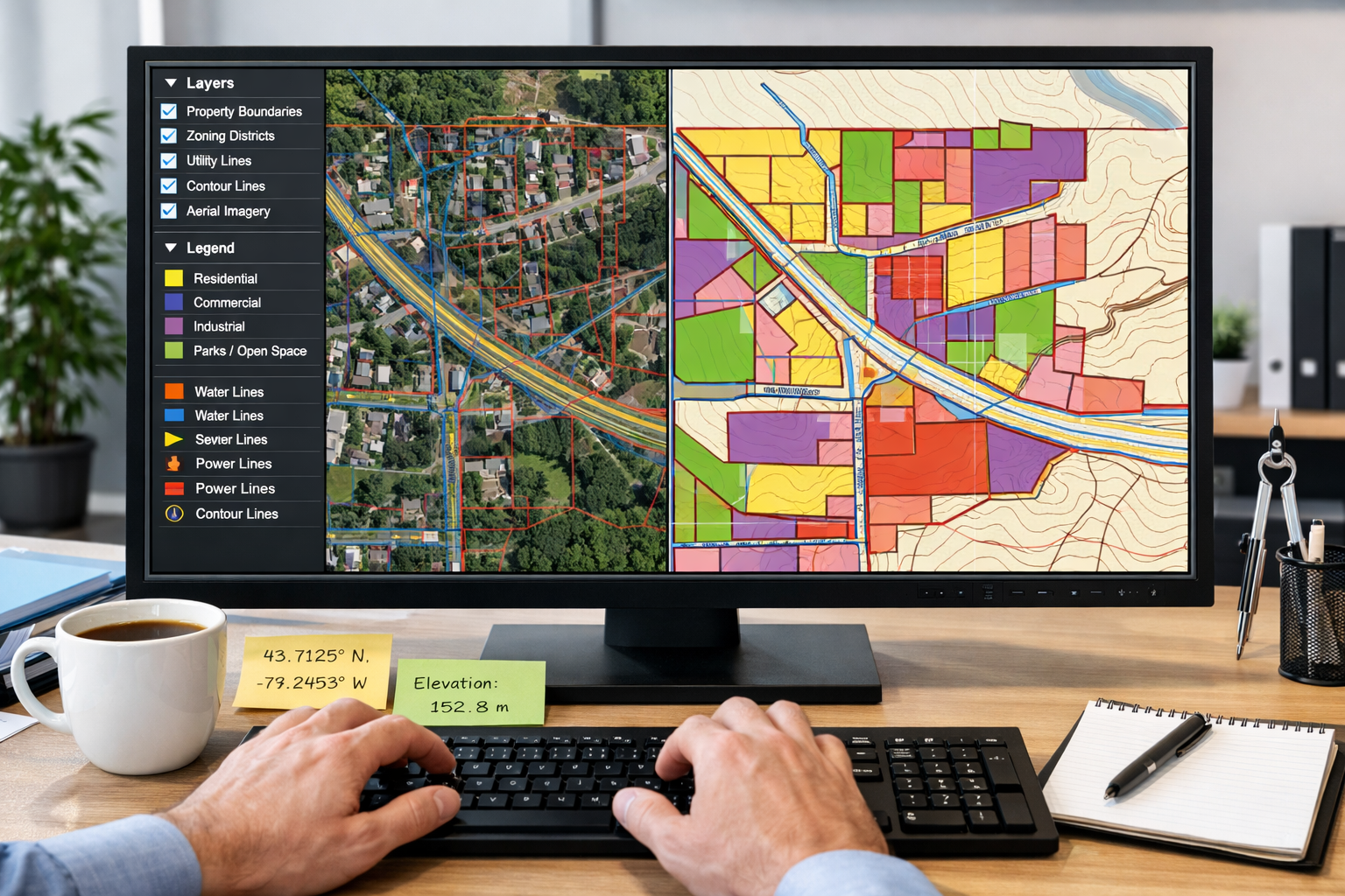
At its core, GIS Integration in Property Surveying: Overlaying Data for Smarter Land Decisions involves creating layered maps where each layer represents a different type of information:
🗺️ Property Boundaries and Parcels – Legal descriptions, ownership records, easements
🏗️ Zoning Districts – Permitted uses, height restrictions, setback requirements
⚡ Utility Infrastructure – Water, sewer, electric, gas, telecommunications
🌊 Environmental Constraints – Floodplains, wetlands, protected habitats
📐 Topographic Data – Elevation, slope, drainage patterns
🏛️ Historical Records – Previous surveys, archeological sites, contamination
When these layers are overlaid on an interactive map, patterns and relationships that would otherwise remain hidden become immediately apparent. A commercial property surveying professional can instantly identify whether a proposed development site intersects with protected wetlands, conflicts with existing utility easements, or violates zoning setback requirements.
The Evolution from Traditional to Integrated Surveying
Traditional surveying relied on isolated data sources. A surveyor might collect field measurements, then separately consult paper zoning maps, utility atlases, and topographic surveys. This fragmented approach created several challenges:
- Data inconsistencies between different sources
- Time-consuming manual cross-referencing of multiple documents
- Difficulty visualizing spatial relationships between different data types
- Limited ability to perform complex spatial analysis
- Outdated information due to infrequent updates
The digital transformation of surveying has fundamentally changed this paradigm. AI systems now handle core surveying workflows, automatically classifying terrain, identifying markers, flagging anomalies, and generating preliminary surface models without manual processing[1]. This reduces data processing time significantly while surveyors focus on applying expertise rather than handling raw field data[1].
Modern UAV systems integrate synchronized sensor arrays combining LiDAR, photogrammetry cameras, multispectral sensors, and thermal imaging, capturing work that previously required multiple site visits in a single detailed flight[1]. Autonomous drones can now automatically adjust altitude, angle, and sensor selection for optimal readings using predictive modeling[1].
The Role of Real-Time 3D Digital Twins
One of the most significant advances in GIS Integration in Property Surveying: Overlaying Data for Smarter Land Decisions is the emergence of real-time 3D digital twins. These interactive 3D models update continuously as new data is collected, allowing visualization of land behavior under various conditions[1]:
- Slope erosion projections under different rainfall scenarios
- Water flow simulations showing drainage patterns and flood risk
- Vegetation pattern changes over time and seasons
- Infrastructure stress testing for proposed developments
All of these analyses can be performed within a single interactive model[1], providing stakeholders with unprecedented insight into how land will respond to development activities. This capability is particularly valuable for structural surveys where understanding subsurface conditions and load-bearing capacity is critical.
Centralizing Critical Data Layers for Development Planning
Building a Comprehensive GIS Database
The foundation of effective GIS Integration in Property Surveying: Overlaying Data for Smarter Land Decisions is a well-structured database that consolidates information from diverse sources. In 2026, this typically involves:
Municipal Data Sources:
- Assessor parcel maps and property records
- Zoning ordinances and overlay districts
- Building permits and development approvals
- Infrastructure as-built drawings
- Public works maintenance records
Survey Data Sources:
- GPS/GNSS field measurements with centimeter-level accuracy[1]
- LiDAR point clouds and elevation models
- Photogrammetric imagery and orthophotos
- Ground-penetrating radar for subsurface utilities
- Historical survey monuments and control networks
Environmental Data Sources:
- FEMA flood insurance rate maps (FIRMs)
- Wetland delineations and habitat surveys
- Soil surveys and geotechnical investigations
- Contamination records and environmental assessments
- Climate and weather pattern data
Infrastructure Data Sources:
- Utility company as-built records
- Fiber optic and telecommunications networks
- Transportation corridor right-of-way maps
- Drainage and stormwater infrastructure
- Energy transmission corridors
A real-world example demonstrates the power of this integration: Sheffield City Council modernized its Public Rights of Way records by replacing fragmented legacy data with accurate, field-verified surveys using an Eos Skadi 100 GNSS receiver and Esri's ArcGIS QuickCapture, creating an evidence-grade dataset for maintenance and liability decisions[2].
Coordinate Systems and Datum Accuracy
One often-overlooked aspect of GIS integration is ensuring all data layers use compatible coordinate systems and reference datums. The U.S. DOT is updating coordinate frames and implementing a new geopotential datum in 2026 to create a more accurate model of Earth's shape, aligning U.S. mapping with international standards[4].
GPS/GNSS systems now provide real-time data with centimeter-level accuracy[1], but this precision is only valuable when all data sources reference the same spatial framework. Organizations like Texas A&M University are combining ground-truthed drone imagery with high-accuracy GNSS data to validate spatial information—as demonstrated with invasive species tracking in coastal prairies, ensuring native and invasive species are identified correctly for restoration efforts[2].
For professionals conducting RICS building surveys or property certification work, coordinate system compatibility ensures that survey measurements integrate seamlessly with municipal GIS databases and engineering design files.
Data Quality and Validation Protocols
The value of GIS Integration in Property Surveying: Overlaying Data for Smarter Land Decisions depends entirely on data quality. In 2026, best practices include:
| Quality Dimension | Validation Method | Acceptable Threshold |
|---|---|---|
| Positional Accuracy | Ground control point verification | ±5cm horizontal, ±10cm vertical |
| Attribute Completeness | Automated field validation rules | 95% of required fields populated |
| Temporal Currency | Metadata timestamp tracking | Updates within 30 days of field collection |
| Logical Consistency | Topology rules and constraint checking | Zero gaps/overlaps in parcel boundaries |
| Source Lineage | Complete provenance documentation | Full chain of custody from collection to publication |
Surveyors are increasingly using GIS tools to capture ecological data and forecast environmental impacts before ground is broken, playing a vital role in guiding sustainable land development decisions[1]. This requires rigorous validation to ensure recommendations are based on reliable information.
Step-by-Step GIS Analysis for Development Planning
Tutorial: Conducting Site Suitability Analysis
One of the most powerful applications of GIS Integration in Property Surveying: Overlaying Data for Smarter Land Decisions is site suitability analysis—systematically evaluating potential development sites against multiple criteria. Here's a practical workflow for 2026:
Step 1: Define Development Requirements
Begin by establishing clear criteria based on the proposed use. For a commercial development, this might include:
- Minimum parcel size: 2 acres
- Zoning: Commercial or mixed-use districts
- Road access: Within 500 feet of arterial street
- Utilities: Water and sewer available
- Topography: Slopes less than 15%
- Environmental: Outside 100-year floodplain
Step 2: Create Individual Constraint Layers
Using GIS software, create separate layers for each criterion:
- Parcel Size Layer: Query assessor database for parcels ≥2 acres
- Zoning Layer: Select commercial and mixed-use zones from municipal zoning map
- Access Layer: Create 500-foot buffer around arterial streets
- Utility Layer: Identify areas with existing water/sewer infrastructure
- Slope Layer: Derive from digital elevation model, classify as suitable (<15%) or unsuitable (≥15%)
- Floodplain Layer: Import FEMA FIRM data, exclude Special Flood Hazard Areas
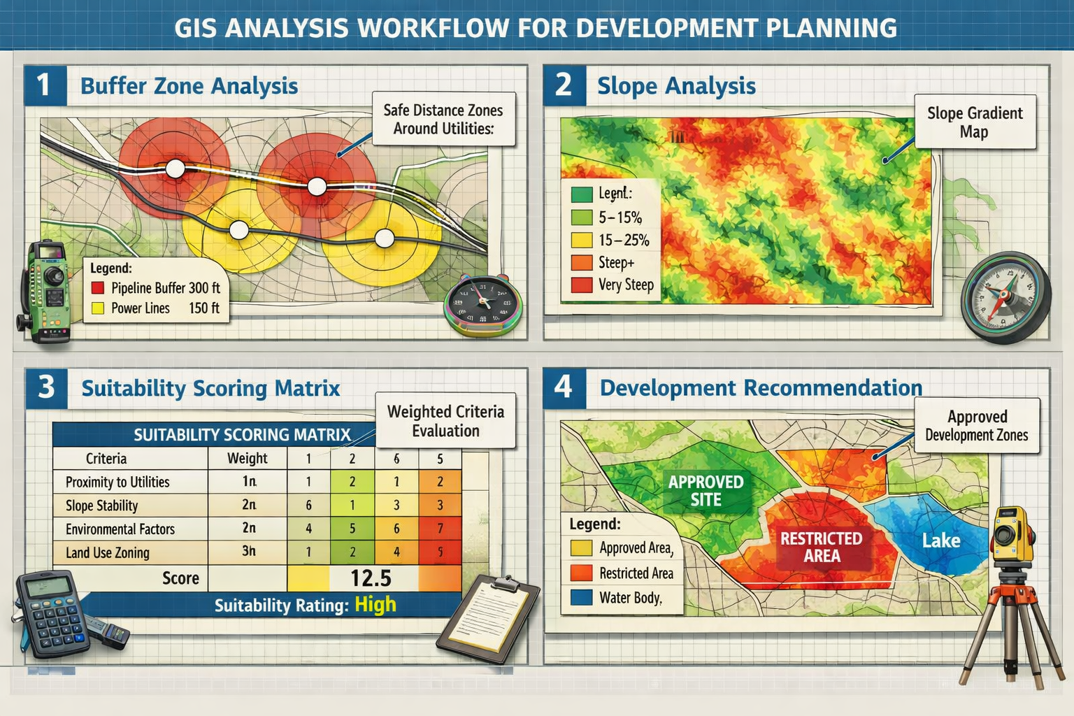
Step 3: Overlay Analysis and Scoring
Modern GIS platforms allow weighted overlay analysis where each criterion receives an importance score. For example:
- Zoning compliance: 30% weight (mandatory)
- Utility availability: 25% weight (high cost if unavailable)
- Slope suitability: 20% weight (affects construction costs)
- Road access: 15% weight (important for commercial)
- Parcel size: 10% weight (minimum threshold already met)
The GIS system calculates composite scores for all parcels, highlighting the most suitable locations. This type of analysis is invaluable for commercial building surveys where multiple stakeholders need to evaluate alternative sites.
Step 4: Visualize and Communicate Results
Cloud platforms now provide instant file sharing, 3D visualization in browsers, real-time revision syncing, and integrated communication with engineers and architects[1]. This ensures stakeholders always have access to the latest survey version rather than outdated PDFs[1].
Create interactive maps showing:
- Heat maps indicating suitability scores (green = highly suitable, red = unsuitable)
- Comparison tables ranking top candidate sites
- 3D visualizations showing development context and neighboring properties
- Report dashboards with automated metrics and statistics
Tutorial: Buffer Zone Analysis for Utility Conflicts
Another common GIS analysis task is identifying potential conflicts between proposed development and existing infrastructure. Here's how to perform buffer zone analysis:
Step 1: Import Utility Infrastructure Data
Load utility layers from municipal GIS databases or utility company as-built records:
- Water mains and service lines
- Sanitary sewer and storm drains
- Electric transmission and distribution
- Natural gas pipelines
- Telecommunications conduits
Step 2: Create Regulatory Buffer Zones
Different utilities have different setback requirements. Create buffer polygons around each utility type:
- High-pressure gas lines: 50-foot buffer zone
- Electric transmission: 100-foot buffer zone
- Water mains: 10-foot buffer zone
- Sewer lines: 10-foot buffer zone
Step 3: Overlay with Development Footprint
Import the proposed building footprint, parking areas, and landscaping plan. The GIS system will automatically identify where development elements intersect with buffer zones, flagging potential conflicts that require design modifications or utility relocation.
This analysis is particularly important for valuation of commercial property where utility conflicts can significantly impact development costs and timelines.
Tutorial: Slope and Drainage Analysis
Understanding terrain behavior is critical for development planning. Modern GIS tools make sophisticated hydrological analysis accessible:
Step 1: Generate Digital Elevation Model (DEM)
Process LiDAR point cloud or photogrammetric data to create a high-resolution DEM showing elevation at every point across the site.
Step 2: Calculate Slope Percentage
GIS software automatically calculates slope from the DEM, classifying terrain into categories:
- 0-5%: Suitable for all development types
- 5-10%: Suitable with standard grading
- 10-15%: Requires engineered grading
- 15-25%: Limited development, erosion control required
-
25%: Generally unsuitable for development
Step 3: Perform Flow Accumulation Analysis
The GIS system simulates water flow across the terrain, identifying:
- Natural drainage channels where water concentrates
- Potential flooding areas during heavy rainfall
- Optimal locations for stormwater management features
- Erosion-prone slopes requiring stabilization
Real-time 3D digital twins allow visualization of land behavior under various conditions, including water flow simulations[1], enabling designers to test different stormwater management scenarios before finalizing plans.
Advanced GIS Applications Transforming Property Surveying in 2026
AI-Powered Automated Feature Extraction
The surveying profession in 2026 is experiencing accelerating digital transformation driven by pressure to deliver faster, more accurate results while navigating workforce shortages and evolving client expectations[3]. The convergence of AI, cloud platforms, and interoperable hardware fundamentally reshapes how spatial data is captured, processed, and shared[3].
Machine learning algorithms now automatically identify and classify features from imagery and point cloud data:
- Building footprints extracted from aerial imagery
- Pavement edges and road centerlines from LiDAR data
- Vegetation classification (trees, shrubs, grass) from multispectral sensors
- Utility poles and overhead lines from photogrammetric models
- Property boundary evidence (fences, hedgerows, monuments) from field data
This automation dramatically reduces the time required to create base maps and allows surveyors to focus on interpretation, analysis, and client consultation rather than manual digitizing.
Building Information Modeling (BIM) Integration
Building Information Modeling (BIM) integration continues gaining traction with land surveyors increasingly collaborating with architects, engineers, and construction professionals to integrate geospatial data into BIM models[1]. This integration enhances project planning, reduces conflicts, and improves construction project efficiency[1].
The workflow typically involves:
- Survey data collection using total stations, GNSS, and laser scanning
- Point cloud registration and georeferencing to project coordinate system
- Export to BIM-compatible formats (IFC, RVT, DWG)
- Integration with architectural and MEP models in platforms like Revit or Navisworks
- Clash detection identifying conflicts between existing conditions and proposed design
- As-built verification comparing constructed elements to design intent
For professionals providing RICS valuations or property certification services, BIM-integrated survey data provides unprecedented detail about building conditions and compliance with approved plans.
GIS-Driven Asset Management Systems
Municipalities and asset owners are adopting GIS-driven asset management systems to manage aging infrastructure with constrained resources[3]. This creates demand for surveyors providing data that feeds comprehensive lifecycle management systems, offering value beyond traditional project boundaries[3].
Innovations in 3D GIS and modeling, combined with AI and real-time spatial insights, enable smarter decision-making and reduced risk throughout an asset's lifecycle[3].
Key components of GIS-driven asset management:
📍 Spatial Asset Inventory – Precise location and attributes of every infrastructure element
📊 Condition Assessment Data – Inspection findings, maintenance history, performance metrics
💰 Lifecycle Cost Modeling – Replacement timing and budget forecasting
⚠️ Risk Analysis – Failure probability and consequence assessment
🔧 Work Order Management – Maintenance scheduling and crew dispatch
📈 Performance Dashboards – Real-time monitoring and trend analysis
Surveyors who can provide accurate, well-attributed spatial data for asset management systems position themselves as long-term partners rather than one-time service providers.
Reality Capture and Immersive Visualization
Reality capture has evolved from a specialized offering to an increasingly accessible toolset that surveying firms of all sizes can deploy, with user-friendly tools and broader platform support making implementation easier in 2026[3]. Enhanced by AI, machine learning, and cloud-based platforms, spatial data is becoming a common visual language for stakeholder alignment[3].
Modern reality capture workflows include:
- Terrestrial laser scanning for detailed building interiors and facades
- Mobile mapping systems for corridor and street-level data collection
- UAV photogrammetry for large-area coverage and vertical structures
- 360-degree panoramic photography for immersive site documentation
- Underwater sonar scanning for marine and waterfront properties
The resulting point clouds and 3D models can be viewed in:
- Virtual reality (VR) headsets for immersive site walkthroughs
- Augmented reality (AR) tablets overlaying design on existing conditions
- Web-based viewers accessible to stakeholders without specialized software
- Integrated project platforms combining survey data with schedules and budgets
For homebuyer survey clients, immersive visualization makes complex structural issues immediately understandable, improving communication and decision-making.
Practical Implementation: Getting Started with GIS Integration
Selecting the Right GIS Platform
Choosing an appropriate GIS platform depends on several factors:
Enterprise Solutions:
- Esri ArcGIS: Industry standard, comprehensive toolset, extensive support
- Bentley MicroStation: Strong CAD integration, engineering focus
- Autodesk Civil 3D: Seamless AutoCAD compatibility, civil engineering workflows
Cloud-Based Platforms:
- ArcGIS Online: Browser-based, no installation required, collaborative
- QGIS Cloud: Open-source foundation, cost-effective
- Mapbox: Customizable, developer-friendly, modern interface
Mobile Field Data Collection:
- Esri ArcGIS QuickCapture: Rapid point collection, offline capable
- Fulcrum: Customizable forms, photo attachments, GPS tracking
- Survey123: Form-based surveys, repeatable data collection
For firms just beginning their GIS integration journey, starting with cloud-based platforms minimizes upfront investment while providing access to powerful analytical tools.
Building Internal GIS Capabilities
Successful GIS Integration in Property Surveying: Overlaying Data for Smarter Land Decisions requires more than just software—it requires skilled personnel and organizational commitment.
Training and Skill Development:
✅ Formal GIS certification programs (Esri Technical Certification, GISP credential)
✅ Online learning platforms (Esri Training, Udemy, Coursera)
✅ Vendor-specific workshops on new tools and workflows
✅ Professional conferences (ASPRS, ACSM, URISA)
✅ Cross-training with municipal GIS departments and engineering firms
Organizational Integration:
- Designate a GIS coordinator responsible for standards and quality control
- Establish data management protocols for file naming, metadata, and archiving
- Create standardized templates for common analysis tasks
- Document workflows so knowledge isn't siloed with individual staff
- Schedule regular reviews of new technologies and methodologies
Data Acquisition Strategies
Building a comprehensive GIS database requires systematic data acquisition:
Municipal Data Partnerships:
Many municipalities provide free or low-cost access to GIS data for professional users. Establish relationships with:
- Planning and zoning departments
- Public works and utilities
- Assessor and recorder offices
- Emergency management agencies
- Regional planning commissions
Commercial Data Providers:
For areas where municipal data is limited, commercial providers offer:
- Parcel boundaries and ownership (CoreLogic, DataQuick)
- Aerial imagery and elevation data (Nearmap, Maxar)
- Demographic and market data (Esri Business Analyst, Nielsen)
- Environmental screening databases (EDR, Environmental Data Resources)
Field Data Collection:
High-value projects justify custom field data collection:
- Boundary surveys with GNSS receivers providing centimeter accuracy
- Topographic surveys using total stations or laser scanning
- Utility locating with electromagnetic detection and ground-penetrating radar
- Environmental assessments with soil sampling and wetland delineation
Organizations combining ground-truthed field data with high-accuracy GNSS validation ensure the highest quality spatial information[2].
Overcoming Common Challenges in GIS Integration
Data Compatibility and Standardization
One of the most frequent obstacles in GIS Integration in Property Surveying: Overlaying Data for Smarter Land Decisions is incompatible data formats and inconsistent standards.
Common Issues:
- Coordinate system mismatches between datasets
- Attribute schema differences (different field names for the same information)
- Geometry type inconsistencies (points vs. polygons for the same features)
- Temporal misalignment (datasets from different time periods)
- Scale and resolution differences (mixing detailed surveys with generalized maps)
Solutions:
🔧 Implement data transformation workflows using FME or ArcGIS Data Interoperability
🔧 Create crosswalk tables mapping between different attribute schemas
🔧 Establish internal data standards based on industry frameworks (FGDC, ISO 19115)
🔧 Use middleware tools that automatically harmonize data from multiple sources
🔧 Maintain metadata documentation explaining data lineage and transformations
Managing Data Volume and Performance
Modern surveying generates massive datasets. A single LiDAR flight can produce billions of points; reality capture models can exceed hundreds of gigabytes.
Performance Optimization Strategies:
- Use spatial indexing to accelerate query performance
- Implement level-of-detail (LOD) rendering showing simplified geometry at large scales
- Employ tiled data services rather than loading entire datasets
- Leverage cloud processing for computationally intensive analyses
- Archive completed projects to separate storage, keeping active databases lean
Cloud platforms now provide instant file sharing and real-time revision syncing[1], addressing performance challenges while maintaining accessibility.
Ensuring Data Security and Privacy
GIS databases often contain sensitive information including property ownership, infrastructure locations, and environmental conditions. Proper security protocols are essential:
Security Best Practices:
🔒 Role-based access control limiting who can view, edit, or delete data
🔒 Encryption for data at rest and in transit
🔒 Regular backups with off-site storage and disaster recovery testing
🔒 Audit logging tracking all data access and modifications
🔒 Compliance with regulations (GDPR, CCPA, critical infrastructure protection)
For firms handling RICS valuations or valuation for probate, protecting client confidentiality while maintaining data accessibility for authorized users requires careful system design.
The Future of GIS Integration in Property Surveying

Emerging Technologies Shaping 2026 and Beyond
The surveying profession continues to evolve rapidly. According to Trimble experts, accelerating digital transformation is driven by pressure to deliver faster, more accurate results while navigating workforce shortages and evolving client expectations[3].
Key Technology Trends:
🚁 Autonomous survey platforms – Drones and ground robots conducting routine surveys with minimal human supervision
🤖 AI-powered quality control – Automated detection of survey errors and anomalies
☁️ Edge computing – Processing data in the field rather than waiting for office upload
🌐 5G connectivity – Real-time streaming of high-bandwidth survey data
🔗 Blockchain verification – Immutable records of survey data and property transactions
👓 Mixed reality interfaces – Holographic display of GIS data overlaid on physical sites
Integration with Smart City Initiatives
Municipalities worldwide are implementing smart city technologies that rely heavily on GIS integration. Surveyors play a critical role in establishing the spatial foundation for:
- IoT sensor networks monitoring traffic, air quality, and infrastructure conditions
- Digital permitting systems automating development review and approval
- Predictive maintenance using AI to forecast infrastructure failures
- Citizen engagement platforms allowing residents to report issues and access information
- Resilience planning modeling climate change impacts and adaptation strategies
The U.S. DOT's GIS Strategic Plan for 2026-30 emphasizes creating more accurate models of Earth's shape and aligning mapping with international standards[4], supporting these smart city initiatives.
Sustainability and Environmental Stewardship
Surveyors are increasingly using GIS tools to capture ecological data and forecast environmental impacts before ground is broken[1], playing a vital role in guiding sustainable land development decisions.
GIS Applications for Sustainability:
🌱 Carbon sequestration mapping – Quantifying vegetation's climate benefits
🌱 Green infrastructure planning – Optimizing stormwater management and urban forests
🌱 Renewable energy siting – Identifying optimal locations for solar and wind facilities
🌱 Habitat connectivity analysis – Preserving wildlife corridors in development areas
🌱 Climate adaptation planning – Modeling sea level rise and extreme weather impacts
These capabilities position surveyors as essential contributors to sustainable development, not just technical service providers.
Expanding Professional Opportunities
GIS Integration in Property Surveying: Overlaying Data for Smarter Land Decisions creates new service offerings and revenue streams:
- GIS consulting for municipalities lacking internal expertise
- Custom application development creating specialized tools for clients
- Data as a service providing ongoing access to curated spatial databases
- Training and education teaching clients to use GIS tools effectively
- Expert witness services providing spatial analysis for litigation
Firms that embrace GIS integration position themselves as strategic advisors rather than commodity service providers, commanding premium fees and building long-term client relationships.
Conclusion: Embracing GIS Integration for Competitive Advantage
The transformation of property surveying through GIS Integration in Property Surveying: Overlaying Data for Smarter Land Decisions is no longer optional—it's essential for remaining competitive in 2026. The ability to centralize zoning boundaries, utility infrastructure, environmental constraints, and topographic data onto interactive platforms enables faster, more accurate, and more defensible land development decisions.
As AI systems automate routine data processing, cloud platforms enable seamless collaboration, and 3D digital twins provide immersive visualization, surveyors can focus on what they do best: applying professional judgment to complex spatial problems. The firms that thrive will be those that view GIS not as a software tool but as a fundamental framework for delivering value to clients.
Actionable Next Steps
For surveying professionals ready to advance their GIS integration capabilities:
Immediate Actions (This Month):
✅ Audit your current data sources – Inventory what spatial data you already have and identify gaps
✅ Establish municipal partnerships – Contact local GIS coordinators to discuss data sharing
✅ Evaluate GIS platforms – Test cloud-based options with free trials before committing
✅ Identify a pilot project – Choose a current project to test GIS workflows
Short-Term Goals (Next Quarter):
✅ Invest in training – Enroll key staff in GIS certification programs
✅ Standardize data formats – Create templates and protocols for consistent data management
✅ Upgrade field equipment – Ensure GPS/GNSS receivers provide centimeter-level accuracy
✅ Document workflows – Create step-by-step guides for common GIS analyses
Long-Term Strategy (Next Year):
✅ Develop specialized expertise – Focus on high-value niches like asset management or BIM integration
✅ Build a comprehensive database – Systematically acquire and integrate data layers for your service area
✅ Market new capabilities – Educate clients about the value of GIS-integrated surveys
✅ Monitor emerging technologies – Stay current with AI, reality capture, and visualization tools
The convergence of GIS technology with property surveying creates unprecedented opportunities for professionals willing to embrace change. By overlaying diverse data sources onto interactive platforms, surveyors transform raw spatial information into actionable intelligence—enabling smarter land decisions that benefit clients, communities, and the environment.
Whether you're conducting commercial property surveying for major developments, providing RICS home survey services for residential buyers, or supporting municipal infrastructure planning, GIS integration enhances every aspect of your practice. The question is not whether to adopt these technologies, but how quickly you can implement them to serve your clients better than ever before.
References
[1] Future Land Surveying 2026 – https://haller-blanchard.com/future-land-surveying-2026/
[2] 2026 01 January – https://eos-gnss.com/newsletters/2026-01-january
[3] Doubling Down On Digital – https://amerisurv.com/2026/02/01/doubling-down-on-digital/
[4] Us Dot Gis Strategic Plan 2026 30 – https://www.transportation.gov/sites/dot.gov/files/2025-12/US-DOT-GIS-Strategic-Plan-2026-30.pdf