Imagine standing at a construction site, tablet in hand, instantly viewing not just property boundaries but also zoning regulations, underground utilities, historical land use, and future development plans—all layered together in a single, interactive map. This is the power of GIS integration in property surveying transforming the profession in 2026. The surveying industry is experiencing a fundamental digital shift, moving from isolated project-based work to comprehensive data systems that deliver ongoing value through sophisticated spatial analysis and visualization.[6]
GIS Integration in Property Surveying: Enhancing Data Visualization and Decision-Making represents more than just technological advancement—it's reshaping how professionals approach land use analysis, project planning, and stakeholder communication. By overlaying multiple datasets including zoning information, boundaries, and utility locations in unified maps, surveyors can now make faster, more informed decisions that reduce risk and improve project outcomes.[4]
Key Takeaways
✅ GIS has become the central platform for managing spatial data in surveying, enabling professionals to overlay zoning, boundaries, utilities, and topography in unified visualization systems that dramatically improve decision-making speed and accuracy.
✅ AI-enhanced predictive capabilities now allow surveyors to analyze historical land changes, project future developments, and support real-time decision-making through machine learning algorithms that interpret satellite imagery and LiDAR data faster than human teams.[3]
✅ Cloud-based integration provides project teams with real-time access to updated land information within hours rather than days, addressing the critical challenge of static reports becoming outdated as conditions change.[3]
✅ Reality capture technologies including 360° imagery, drone surveys, and LiDAR have transitioned from pilot projects to standard operations, providing richer contextual data while reducing on-site time requirements.[1]
✅ Workforce shortages are accelerating technology adoption, creating pressure to deliver faster, more accurate results through integrated GIS platforms that reduce labor intensity while maintaining quality standards.[6]
Understanding GIS Integration in Modern Property Surveying
Geographic Information Systems have evolved from specialized mapping tools into the central nervous system for spatial data in the surveying profession. In 2026, GIS platforms serve as comprehensive data management infrastructure that connects field collection, analysis, visualization, and decision-making into seamless workflows.
What Makes GIS Essential for Property Surveyors
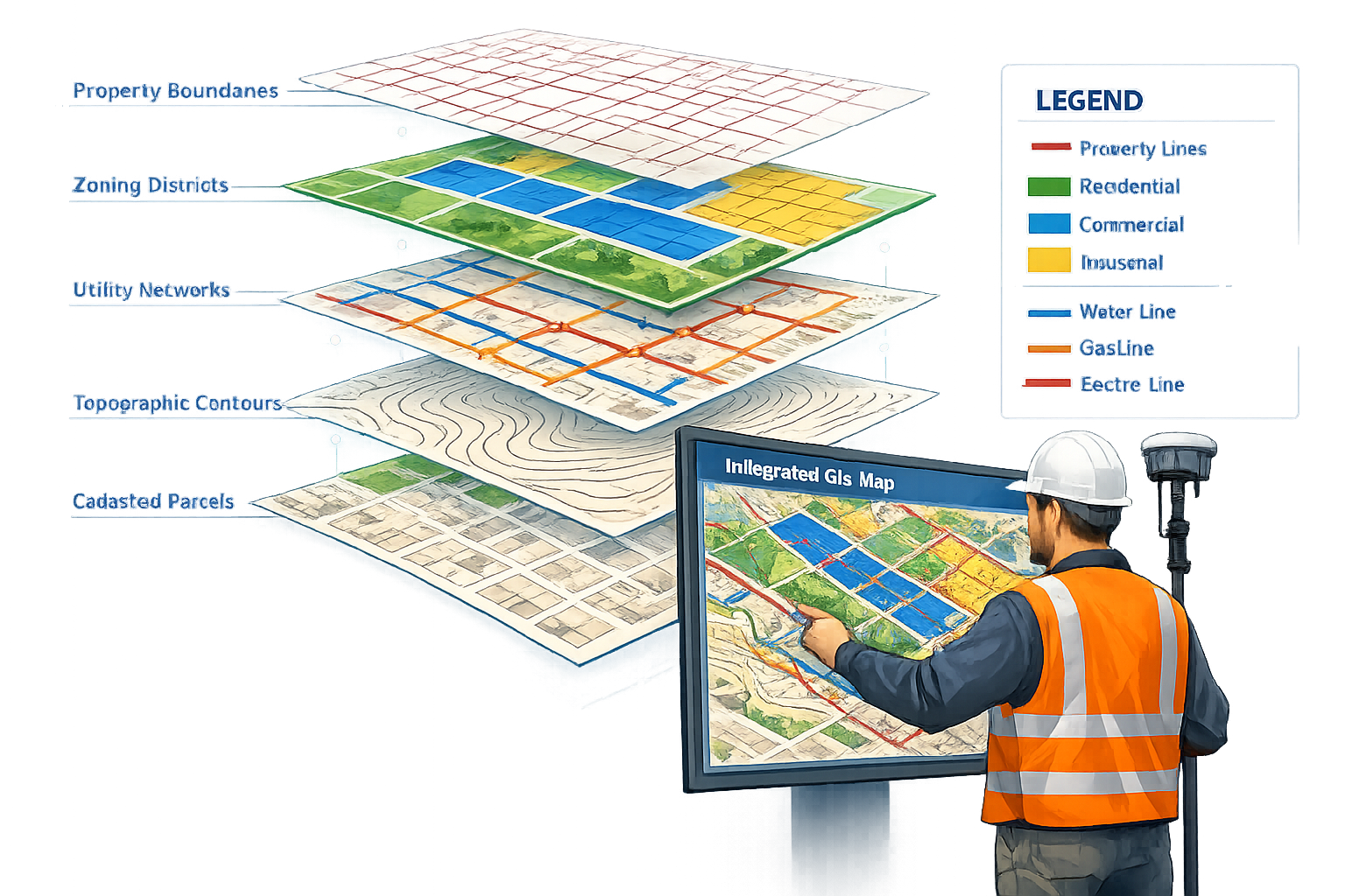
At its core, GIS integration allows surveyors to combine multiple data layers—cadastral boundaries, topographic features, zoning regulations, utility infrastructure, environmental constraints, and development plans—into unified spatial databases. This integration fundamentally changes how professionals approach commercial property surveying and land use analysis.
Key capabilities that define modern GIS integration include:
- Multi-layer data visualization that displays complex relationships between property boundaries, infrastructure, and regulatory constraints
- Spatial analysis tools that calculate areas, distances, slopes, and relationships automatically
- Real-time data updates that keep project teams synchronized with current conditions
- Historical data tracking that reveals land use evolution and supports predictive modeling
- Stakeholder communication through interactive maps that translate technical findings into accessible formats
The shift toward GIS-centric management represents a fundamental change from traditional surveying approaches. Rather than producing static deliverables for individual projects, surveyors now contribute to living data systems that support ongoing asset lifecycle management at municipal, state, and private organizational levels.[6]
The Data Layer Revolution in Land Use Analysis
The true power of GIS Integration in Property Surveying: Enhancing Data Visualization and Decision-Making emerges when professionals overlay diverse datasets to reveal patterns and relationships invisible in isolated views. Consider a typical land development scenario:
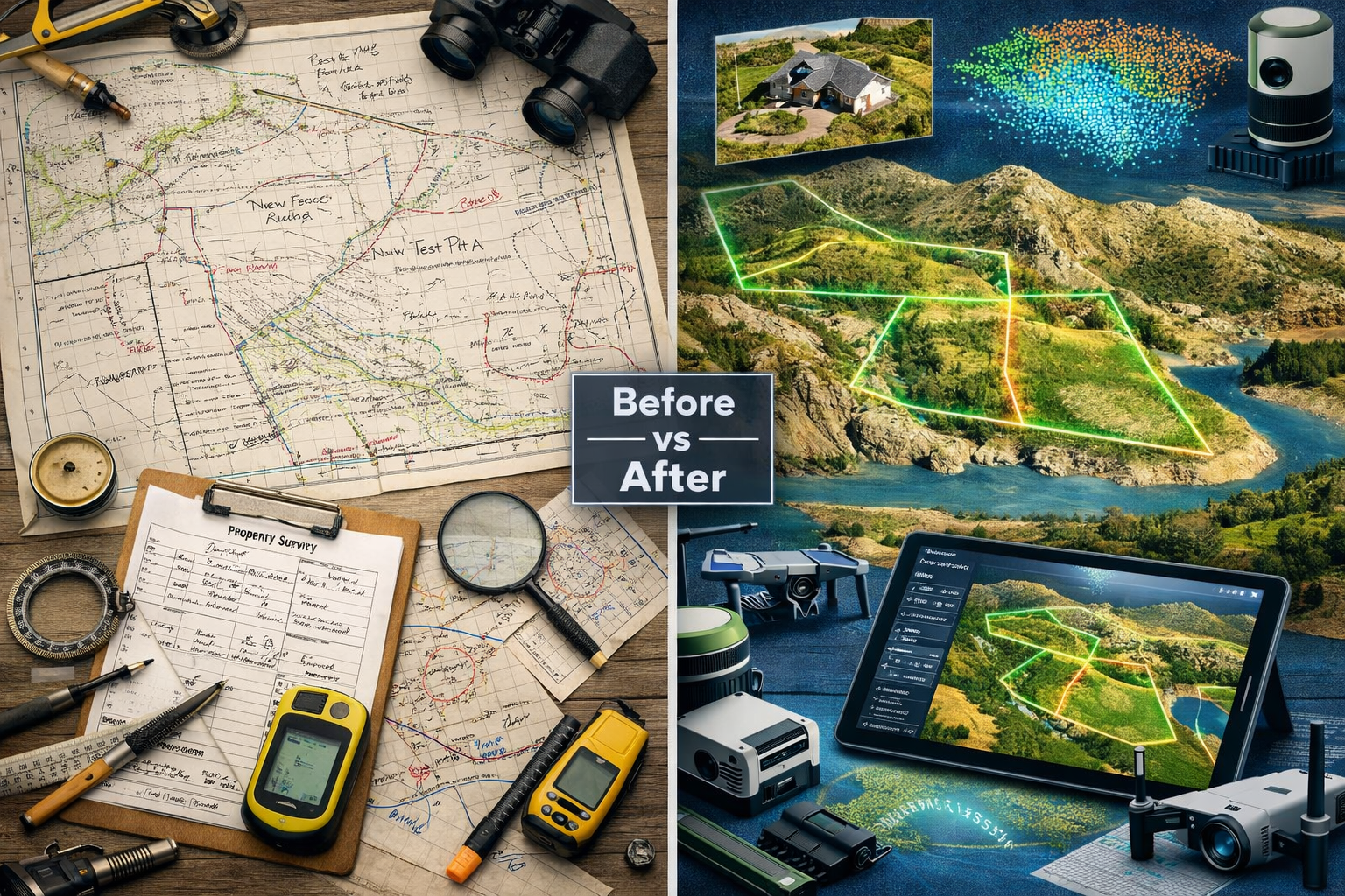
Traditional Approach (Pre-GIS Integration):
- Surveyor produces boundary survey
- Planner reviews separate zoning map
- Engineer consults utility company records
- Environmental consultant examines separate wetland maps
- Each professional works with different data formats and coordinate systems
- Integration happens manually through meetings and document comparison
GIS-Integrated Approach:
- All data layers exist in unified spatial database
- Boundary survey, zoning, utilities, environmental constraints visible simultaneously
- Automated conflict detection identifies issues before fieldwork
- Real-time updates reflect changing conditions
- Collaborative access allows all stakeholders to work from same information
This transformation has particular impact on complex projects requiring coordination across multiple disciplines. When conducting RICS building surveys, professionals can now access comprehensive property context including historical modifications, nearby infrastructure, and regulatory constraints through integrated GIS platforms.
Core Components of Effective GIS Integration
Successful GIS integration in property surveying requires several interconnected components working together:
| Component | Function | Impact on Surveying |
|---|---|---|
| Data Collection Hardware | GPS/GNSS receivers, total stations, drones, LiDAR scanners | Captures spatial data with centimeter-level accuracy[2] |
| Cloud-Based Platforms | Centralized data storage and processing | Enables real-time access and collaboration across project teams[3] |
| GIS Software | ArcGIS, QGIS, specialized surveying platforms | Provides analysis, visualization, and data management tools |
| Mobile Applications | Field data collection apps | Allows surveyors to update and access GIS data on-site |
| Integration APIs | Software connections | Links GIS with CAD, BIM, and project management systems |
| AI/ML Algorithms | Automated analysis and pattern recognition | Accelerates boundary detection and land use classification[3] |
The integration of these components creates workflows that dramatically reduce time requirements while improving accuracy. Advanced GNSS implementations now provide surveyors with centimeter-level accuracy in real-time, enabling professionals to deliver more reliable results for increasingly demanding applications.[2]
How GIS Enhances Data Visualization for Property Surveyors
Visualization represents one of the most transformative aspects of GIS Integration in Property Surveying: Enhancing Data Visualization and Decision-Making. The ability to see spatial relationships, patterns, and conflicts transforms raw data into actionable intelligence that drives better project outcomes.
Multi-Layer Mapping for Comprehensive Property Analysis
Modern GIS platforms allow surveyors to create sophisticated multi-layer visualizations that reveal the complete context of any property or development site. These visualizations typically include:
Foundational Layers:
- 📍 Cadastral boundaries and property parcels
- 🗺️ Topographic contours and elevation data
- 🛰️ Aerial imagery and satellite photography
- 🏗️ Existing structures and improvements
Regulatory and Planning Layers:
- 🏛️ Zoning districts and land use designations
- 📏 Setback requirements and building envelopes
- 🌳 Environmental protection zones and wetlands
- 🚫 Easements and deed restrictions
Infrastructure Layers:
- 💧 Water and sewer lines
- ⚡ Electric and gas utilities
- 📡 Telecommunications infrastructure
- 🚗 Transportation networks and access points
By overlaying these layers, surveyors conducting structural surveys can immediately identify potential conflicts, regulatory constraints, and development opportunities that might require weeks to discover through traditional research methods.
360° Imagery and Street-Level Context
One of the most significant visualization advances in 2026 is the integration of 360° imagery as a standard data component in surveying workflows. This technology has become a core business component particularly valuable for asset management, cadastral mapping, and property assessment.[5]
360° imagery provides several critical advantages:
- Accelerated decision-making by providing street-level context difficult to obtain from LiDAR or aerial imagery alone
- Stakeholder communication that translates technical findings to clients with varying skill levels
- Historical documentation that captures property conditions at specific points in time
- Remote site assessment that reduces need for multiple site visits
When combined with GIS platforms, 360° imagery allows surveyors to navigate properties virtually while accessing overlaid data layers showing boundaries, utilities, and regulatory information. This capability proves particularly valuable when coordinating with clients who cannot easily visit sites or when documenting conditions for subsidence surveys that require temporal comparison.
3D Visualization and Terrain Modeling
The evolution from 2D mapping to 3D visualization has fundamentally changed how surveyors communicate findings and support decision-making. Modern GIS platforms now support sophisticated 3D modeling capabilities including:
Digital Terrain Models (DTM): Representing bare earth topography without vegetation or structures
Digital Surface Models (DSM): Capturing all features including buildings, trees, and infrastructure
3D Building Models: Showing existing structures with accurate heights and footprints
Volumetric Analysis: Calculating cut-and-fill requirements for grading projects
Perhaps most significantly, Gaussian Splatting—a cutting-edge 3D capture technology—is now natively supported in major GIS tools such as ArcGIS.[5] This technology has seen exponential adoption growth in late 2025 due to improvements in fidelity, realism, rendering quality, and dramatically shrinking file sizes that make it practical for professional workflows.
These 3D capabilities transform how surveyors support development planning. Rather than reviewing 2D plans and imagining spatial relationships, stakeholders can now visualize proposed developments in accurate 3D context, identifying sight line issues, shadow impacts, and design conflicts before construction begins.
Time Series Visualization for Predictive Analysis
Organizations are increasingly streaming historic data layers into their GIS systems because time series visualization helps predict future outcomes rather than merely explaining past events.[1] This capability supports numerous surveying applications:
- Landscape evolution tracking showing how properties and neighborhoods have changed over decades
- Pre- and post-event analysis for flooding, coastal erosion, and environmental changes
- Development pattern analysis revealing growth trends and infrastructure demands
- Asset condition monitoring tracking deterioration rates and maintenance needs
For professionals conducting monitoring surveys, the ability to visualize temporal changes in GIS platforms provides powerful tools for detecting movement, settlement, and structural changes that might indicate serious issues requiring intervention.
Interactive Dashboards and Decision Support Tools
Modern GIS platforms extend beyond static maps to provide interactive dashboards that support real-time decision-making. These tools allow surveyors and stakeholders to:
- Filter and query data based on specific criteria
- Perform "what-if" scenarios testing different development options
- Generate automated reports and visualizations
- Access current and historical property information instantly
- Identify trends and patterns through visual analytics
The transition to cloud-based platforms means these dashboards are accessible from any device, enabling project teams to make informed decisions in the field rather than waiting to return to the office. This responsiveness addresses a critical challenge in fast-moving markets like Houston, where demand for real-time, adaptable surveying methods allows teams to access updated land information within hours rather than days.[3]
Improving Decision-Making Through Integrated GIS Workflows
GIS Integration in Property Surveying: Enhancing Data Visualization and Decision-Making delivers its greatest value when visualization capabilities connect to comprehensive workflows that support better, faster decisions across the project lifecycle.
Automated Conflict Detection and Risk Assessment
One of the most powerful decision-support capabilities of integrated GIS systems is automated conflict detection that identifies potential issues before they become expensive problems. Modern platforms can automatically flag:
- Boundary conflicts where property lines overlap or gap
- Zoning violations where proposed uses don't match regulatory designations
- Utility conflicts where proposed construction intersects existing infrastructure
- Environmental constraints where development encroaches on protected areas
- Access issues where properties lack adequate street frontage or easements
These automated checks dramatically reduce the risk of costly surprises during development. When working on commercial property surveying projects, the ability to identify conflicts during planning rather than construction can save clients hundreds of thousands in redesign costs and schedule delays.
AI-Enhanced Analysis and Pattern Recognition
Artificial intelligence has emerged as a transformative force in GIS-integrated surveying workflows. AI now enhances GIS platform capabilities, allowing surveyors and planners to visualize historical land changes, project future developments, and support real-time decision-making.[3]
Machine learning algorithms can:
- Interpret satellite imagery to detect terrain changes and land use patterns
- Analyze LiDAR scans to identify property boundaries and classify features
- Process drone-captured visuals to create detailed site models
- Predict development patterns based on historical trends and current conditions
- Classify land use faster than human teams while maintaining accuracy
These AI capabilities are particularly valuable in large-scale projects where manual analysis would be prohibitively time-consuming. The algorithms can process vast datasets to identify patterns and anomalies that might escape human notice, improving both accuracy and efficiency.
Real-Time Collaboration and Stakeholder Engagement
Cloud-based GIS platforms have transformed surveying from a solitary profession into a collaborative enterprise where multiple stakeholders can access and contribute to shared spatial databases. This collaboration improves decision-making by:
- Eliminating version control issues where team members work from outdated information
- Enabling concurrent review where surveyors, engineers, planners, and clients examine the same data simultaneously
- Facilitating remote participation where stakeholders can contribute without traveling to sites
- Accelerating approval processes where reviewers can access complete information instantly
- Improving communication where technical findings translate into accessible visualizations
For professionals managing complex projects requiring coordination with RICS chartered building surveyors, the ability to share integrated GIS data ensures all parties work from consistent information, reducing misunderstandings and conflicts.
Integration with Building Information Modeling (BIM)
The integration of GIS with Building Information Modeling (BIM) represents one of the most significant workflow advances in 2026. Land surveyors are increasingly collaborating with architects and engineers to integrate geospatial data into BIM models, enhancing project planning, reducing conflicts, and improving overall construction efficiency.[2]
This GIS-BIM integration creates comprehensive digital twins that combine:
- Accurate site context from GIS including topography, boundaries, and existing conditions
- Detailed building models from BIM showing proposed structures and systems
- Infrastructure data showing utilities, access, and surrounding development
- Regulatory information including zoning, setbacks, and environmental constraints
The combined model allows project teams to identify conflicts and optimize designs before construction begins. For example, surveyors can verify that proposed building locations comply with setback requirements, that grading plans account for actual topography, and that utility connections align with existing infrastructure—all within the integrated digital environment.
Predictive Analytics for Development Planning
Organizations are leveraging GIS integration to move beyond reactive surveying toward predictive analytics that inform strategic planning decisions. By analyzing historical patterns, current conditions, and development trends, integrated GIS platforms can:
- Project future infrastructure demands based on growth patterns
- Identify optimal locations for development based on multiple criteria
- Predict property value changes based on planned improvements
- Forecast environmental impacts of proposed developments
- Assess long-term maintenance requirements for infrastructure assets
These predictive capabilities transform how organizations approach asset lifecycle management. Rather than responding to problems as they arise, decision-makers can anticipate needs and allocate resources proactively, reducing costs and improving outcomes over time.
Mobile Decision-Making in the Field
The proliferation of mobile GIS applications has extended decision-making capabilities beyond the office to the field itself. Surveyors equipped with tablets or ruggedized smartphones can now:
- Access complete GIS databases while on-site
- Update information in real-time as conditions change
- Verify findings against multiple data layers immediately
- Communicate with office teams through shared platforms
- Make informed decisions without returning to office
This mobile capability proves particularly valuable when conducting drone surveys where operators can immediately verify that captured imagery covers required areas and meets quality standards, eliminating the need for return visits.
Implementation Strategies for GIS Integration in Surveying Practices
Successfully implementing GIS Integration in Property Surveying: Enhancing Data Visualization and Decision-Making requires careful planning, appropriate technology selection, and ongoing commitment to workflow optimization.
Assessing Organizational Readiness and Needs
Before investing in GIS integration, surveying organizations should conduct thorough readiness assessments that evaluate:
Current Capabilities:
- Existing technology infrastructure and software
- Staff technical skills and training needs
- Data quality and organization standards
- Client expectations and deliverable requirements
Business Drivers:
- Competitive pressures requiring enhanced capabilities
- Client demands for real-time data access
- Workforce constraints requiring efficiency improvements
- Growth opportunities in specialized markets
Resource Availability:
- Budget for software, hardware, and training
- Staff time for implementation and learning
- Technical support requirements
- Data acquisition and conversion needs
This assessment helps organizations prioritize investments and develop realistic implementation timelines that balance capability enhancement with operational continuity.
Selecting Appropriate GIS Platforms and Tools
The GIS technology landscape in 2026 offers numerous options ranging from comprehensive enterprise platforms to specialized surveying solutions. Key selection criteria include:
| Consideration | Questions to Address |
|---|---|
| Functionality | Does the platform support required analysis and visualization capabilities? |
| Integration | Can it connect with existing CAD, GPS, and project management systems? |
| Scalability | Will it accommodate growing data volumes and user counts? |
| Mobile Support | Does it provide robust field data collection capabilities? |
| Cloud vs. On-Premise | Which deployment model best fits security and access requirements? |
| Cost Structure | Are licensing, maintenance, and training costs sustainable? |
| Vendor Support | Does the provider offer adequate technical support and training? |
Many surveying practices find success with hybrid approaches that combine industry-standard platforms like ArcGIS for comprehensive analysis with specialized surveying software for field collection and CAD integration.
Data Migration and Quality Management
Successful GIS integration depends on high-quality spatial data organized according to consistent standards. Organizations must address:
Data Conversion:
- Migrating legacy CAD files and paper records to GIS formats
- Georeferencing historical maps and surveys
- Standardizing coordinate systems and datums
- Validating accuracy during conversion process
Data Quality Standards:
- Establishing accuracy requirements for different data types
- Implementing quality control procedures for new data
- Documenting metadata including source, date, and accuracy
- Regular audits to identify and correct errors
Data Organization:
- Developing logical layer structures and naming conventions
- Creating data dictionaries defining attributes and codes
- Implementing version control for data updates
- Establishing backup and disaster recovery procedures
For practices handling sensitive information related to RICS valuations, data security and access controls must be carefully designed to protect client confidentiality while enabling appropriate collaboration.
Staff Training and Capability Development
The workforce challenges facing the surveying profession in 2026 make effective training programs essential for GIS integration success.[6] Comprehensive training should address:
Technical Skills:
- GIS software operation and analysis tools
- Mobile data collection applications
- GPS/GNSS equipment operation
- Drone piloting and data processing
- AI-assisted analysis tools
Conceptual Understanding:
- Spatial data principles and coordinate systems
- Data quality and accuracy concepts
- Visualization best practices
- Integration workflows and collaboration tools
Ongoing Development:
- Regular updates on new capabilities and tools
- Peer learning and knowledge sharing
- Industry conference participation
- Vendor training and certification programs
Organizations should recognize that GIS integration represents a cultural shift as much as a technological one, requiring patience and support as staff adapt to new workflows and capabilities.
Establishing Workflow Standards and Best Practices
To maximize the value of GIS integration, organizations need standardized workflows that ensure consistency and quality across projects. Key elements include:
- Project initiation procedures defining data requirements and deliverables
- Field collection protocols specifying accuracy standards and quality checks
- Data processing workflows from raw collection through final deliverables
- Quality assurance checkpoints at critical stages
- Client communication standards for sharing data and visualizations
- Archive procedures ensuring completed projects remain accessible
These standards should be documented, regularly reviewed, and updated as technology and client expectations evolve. When conducting specialized work such as damp surveys, standardized workflows ensure that GIS integration enhances rather than complicates established procedures.
Measuring Success and Continuous Improvement
Organizations should establish metrics to evaluate GIS integration success and identify improvement opportunities:
Efficiency Metrics:
- Time required for common tasks (before and after integration)
- Number of site visits required per project
- Data processing time from collection to deliverable
- Revision cycles required to address client feedback
Quality Metrics:
- Error rates in boundary determinations
- Conflict detection rates before versus after integration
- Client satisfaction scores
- Repeat business and referral rates
Business Metrics:
- Revenue per surveyor
- Project profitability
- New capability offerings
- Market share in target segments
Regular review of these metrics helps organizations refine workflows, identify training needs, and justify continued investment in GIS integration capabilities.
Future Trends in GIS Integration for Property Surveying

As 2026 progresses, several emerging trends promise to further enhance GIS Integration in Property Surveying: Enhancing Data Visualization and Decision-Making capabilities.
Reality Capture Becoming Business-as-Usual
Reality capture has transitioned from experimental pilot projects to standard operational practice across the surveying profession.[1] Organizations are now locking in repeatable capture schedules and integrating LiDAR and aerial imagery together in single surveys, providing teams with richer contextual data while reducing on-site time.
This shift toward routine reality capture enables:
- Comprehensive site documentation capturing conditions at specific points in time
- Reduced field time as single visits capture data previously requiring multiple trips
- Enhanced client deliverables including immersive 3D models and virtual tours
- Historical archives supporting future analysis and dispute resolution
The integration of reality capture with GIS platforms creates digital twins of properties and infrastructure that support ongoing asset management and planning decisions.
Expanded AI and Machine Learning Applications
Artificial intelligence applications in GIS-integrated surveying will continue expanding beyond current capabilities. Emerging applications include:
- Automated feature extraction that identifies buildings, roads, vegetation, and other features from imagery without human intervention
- Predictive maintenance modeling that forecasts infrastructure deterioration based on historical patterns
- Optimal route planning for field crews based on traffic, weather, and site conditions
- Intelligent data validation that identifies anomalies and potential errors automatically
- Natural language interfaces allowing users to query GIS databases using conversational commands
These AI enhancements will further reduce the labor intensity of surveying while improving accuracy and consistency.
Integration with Smart City and IoT Platforms
The proliferation of Internet of Things (IoT) sensors in urban environments creates new opportunities for GIS integration. Surveyors will increasingly work with real-time data streams from:
- Traffic sensors monitoring vehicle and pedestrian flows
- Environmental monitors tracking air quality, noise, and weather
- Infrastructure sensors detecting movement, vibration, and structural stress
- Utility sensors monitoring consumption and system performance
Integrating these data streams with traditional surveying information creates comprehensive urban digital twins that support sophisticated planning and management decisions. For professionals involved in project management roles, this integration provides unprecedented visibility into how built environments perform and evolve.
Enhanced Mobile and Augmented Reality Capabilities
Mobile technology will continue advancing with augmented reality (AR) applications that overlay GIS data on real-world views through smartphone and tablet cameras. Surveyors will be able to:
- Visualize underground utilities by pointing devices at streets
- See property boundaries overlaid on physical landscapes
- Review proposed developments in actual site context
- Identify conflicts between existing conditions and plans
- Communicate findings to clients through immersive experiences
These AR capabilities will further improve stakeholder communication and decision-making by making abstract spatial data tangible and intuitive.
Blockchain for Land Records and Transaction Security
Blockchain technology shows promise for creating immutable land records that reduce fraud and streamline property transactions. GIS integration with blockchain-based land registries could provide:
- Transparent ownership histories with tamper-proof records
- Automated transaction processing reducing closing times
- Reduced title insurance costs through improved certainty
- International standardization of property records
- Smart contracts that execute automatically when conditions are met
While widespread adoption remains years away, surveyors should monitor blockchain developments as they may fundamentally reshape how property rights are documented and transferred.
Conclusion
GIS Integration in Property Surveying: Enhancing Data Visualization and Decision-Making has evolved from an emerging technology into essential professional infrastructure in 2026. By overlaying zoning information, property boundaries, utility locations, and countless other data layers in unified spatial platforms, surveyors can now deliver insights and support decision-making processes that were impossible just a few years ago.
The transformation extends far beyond technical capabilities to fundamentally reshape the surveyor's role. Rather than simply measuring and documenting existing conditions, today's professionals contribute to living data systems that support ongoing asset lifecycle management, predictive planning, and collaborative decision-making across entire organizations and communities.
Key Success Factors
Organizations achieving the greatest value from GIS integration share several characteristics:
✅ Strategic vision that views GIS as core infrastructure rather than optional technology
✅ Comprehensive training that develops both technical skills and conceptual understanding
✅ Quality data management ensuring accuracy, consistency, and accessibility
✅ Standardized workflows that embed GIS capabilities into routine operations
✅ Continuous improvement through metrics, feedback, and ongoing optimization
Actionable Next Steps
For surveying professionals and organizations ready to enhance their GIS integration capabilities:
1. Assess Current State: Conduct honest evaluation of existing technology, data quality, staff capabilities, and workflow efficiency to identify specific improvement opportunities.
2. Define Clear Objectives: Establish specific, measurable goals for GIS integration tied to business outcomes such as reduced project time, improved accuracy, or expanded service offerings.
3. Start with High-Value Applications: Rather than attempting comprehensive transformation immediately, focus initial efforts on specific applications where GIS integration delivers clear value, building momentum through early successes.
4. Invest in Training: Allocate adequate resources for comprehensive staff training, recognizing that technology investments only deliver value when people can effectively use them.
5. Establish Data Standards: Develop and document clear standards for data collection, organization, quality control, and metadata to ensure long-term value from GIS investments.
6. Build Collaborative Relationships: Engage with clients, partners, and technology vendors to understand evolving expectations and identify opportunities for enhanced integration and value delivery.
7. Monitor Industry Trends: Stay informed about emerging technologies including AI, reality capture, and mobile capabilities that may offer competitive advantages or become client expectations.
The surveying profession stands at a pivotal moment where digital transformation is no longer optional but essential for competitiveness and relevance. Organizations that embrace GIS integration thoughtfully—balancing technology investment with training, workflow optimization, and quality management—will be positioned to thrive in an increasingly data-driven, collaborative, and demanding professional environment.
For those ready to explore how integrated GIS capabilities can enhance specific surveying applications, consider reviewing specialized resources on commercial property surveying, structural surveys, and other professional services where spatial data integration delivers transformative value.
The future of property surveying is spatial, integrated, and collaborative—and that future is already here. 🗺️
References
[1] Geospatial Trends 2026 – https://www.getmapping.co.uk/geospatial-trends-2026/
[2] Future Land Surveying 2026 – https://haller-blanchard.com/future-land-surveying-2026/
[3] Building The Future Aidriven Land Surveying In Houston S Growing Landscape Nwid 1037 – https://www.realestatebusinessreview.com/news/building-the-future-aidriven-land-surveying-in-houston-s-growing-landscape-nwid-1037.html
[4] The Future Of Land Surveying Technology And Upcoming Trends In 2026 – https://metricop.com/blogs/land-surveying/the-future-of-land-surveying-technology-and-upcoming-trends-in-2026
[5] 6 Geospatial Trends To Watch In 2026 Insights From Intergeo 2025 – https://www.mosaic51.com/community/6-geospatial-trends-to-watch-in-2026-insights-from-intergeo-2025/
[6] Doubling Down On Digital – https://amerisurv.com/2026/02/01/doubling-down-on-digital/