The land surveying industry stands at a transformative crossroads in 2026, where traditional measurement techniques meet cutting-edge artificial intelligence. AI and Machine Learning Revolutionizing Land Survey Data Analysis in 2026 represents more than just technological advancement—it marks a fundamental shift in how surveyors collect, process, and interpret geospatial information. Gone are the days when surveyors spent weeks manually sorting through raw field data or relying solely on human judgment to identify terrain patterns. Today's AI-powered systems can instantly classify terrain features, predict geological risks like floods and landslides, and process massive datasets in real-time, enabling surveying professionals to deliver unprecedented accuracy and efficiency to their clients.
This technological revolution has transformed surveying from a labor-intensive field practice into a sophisticated data science discipline. Modern surveyors now leverage machine learning algorithms that can analyze years of historical data in seconds, autonomous drones that navigate complex terrains without human intervention, and predictive models that anticipate environmental changes before they occur. The integration of artificial intelligence into land survey data analysis has not only accelerated project timelines but has also opened new possibilities for risk assessment, infrastructure monitoring, and environmental planning that were previously impossible with conventional methods.
Key Takeaways
✅ Automated data processing has become standard practice in 2026, with AI systems instantly classifying terrain, identifying markers, and generating preliminary surface models without manual intervention.
✅ Predictive analytics powered by machine learning now enables surveyors to forecast geological changes including soil erosion, landslides, ground subsidence, and flooding by analyzing historical data combined with environmental factors.
✅ Real-time data processing capabilities allow surveyors to make immediate decisions in the field, with AI providing instant analysis and anomaly detection that previously required days or weeks of post-processing.
✅ Autonomous drone operations and AI-enhanced LiDAR technology have dramatically reduced survey costs and time while improving accuracy through self-calibrating instruments and automatic error correction.
✅ Labor cost reduction of up to 40% has been achieved through AI automation of routine tasks, allowing surveying professionals to focus on higher-level analysis and strategic decision-making.
How AI and Machine Learning Are Transforming Land Survey Data Collection
The Shift from Manual to Automated Data Processing
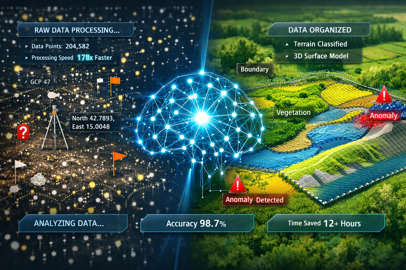
The landscape of land survey data analysis has undergone a remarkable transformation as AI and Machine Learning Revolutionizing Land Survey Data Analysis in 2026 becomes the new industry standard. Traditional surveying methods required teams of professionals to spend countless hours manually sorting, classifying, and analyzing raw field data. This labor-intensive process was not only time-consuming but also prone to human error and inconsistency.
In 2026, AI systems have fundamentally changed this paradigm. These intelligent platforms now instantly classify terrain features, identify boundary markers, flag anomalies, and generate preliminary surface models without human intervention[4]. The automation eliminates the tedious manual sorting of raw field data that once consumed significant portions of project timelines, enabling faster client turnaround times and more competitive pricing structures.
Machine learning algorithms can analyze massive datasets instantly to identify patterns, detect changes, and predict future developments[5]. What previously took weeks of careful human analysis now happens in minutes or even seconds. This speed advantage allows surveying firms to take on more projects simultaneously while maintaining higher quality standards than ever before.
Real-Time Processing Capabilities
One of the most significant advantages of AI integration is the ability to process data in real-time while still in the field. AI-powered workflows now process data at speeds previously unattainable by humans[1], providing surveyors with immediate feedback on data quality, coverage gaps, and potential issues.
This real-time capability transforms how chartered surveyors approach fieldwork. Instead of discovering data gaps or quality issues back at the office, surveyors can now identify and address problems immediately while still on-site. This eliminates costly return visits and ensures comprehensive data collection on the first attempt.
The technology enables instant data analysis through real-time insights, allowing surveyors to make quick decisions in dynamic environments[1][2]. Advanced modeling techniques enable professionals to predict land use and assess environmental impacts more efficiently than traditional methods, providing clients with actionable information while projects are still in early stages.
Enhanced GPS Data Processing and Predictive Capabilities
GPS technology has long been a cornerstone of modern surveying, but AI has elevated its capabilities to new heights. AI enables real-time GPS data analysis and predictive capabilities, including machine learning models that can predict when and where signal outages might occur[6]. This predictive power allows surveyors to adjust routes and schedules accordingly, avoiding areas with poor satellite coverage or planning fieldwork during optimal signal windows.
Machine learning can also optimize travel routes for survey teams, reducing time spent navigating difficult terrains and improving overall field efficiency[6]. These route optimization algorithms consider factors like terrain difficulty, weather conditions, daylight hours, and equipment limitations to create the most efficient survey plans possible.
For firms offering specialized services like boundary surveys, this GPS enhancement means more accurate property line determinations with fewer measurement uncertainties. The AI systems can cross-reference multiple data sources, identify discrepancies, and provide confidence levels for each measurement point.
Predictive Analytics and Risk Assessment in Modern Surveying
AI-Powered Geological Risk Prediction
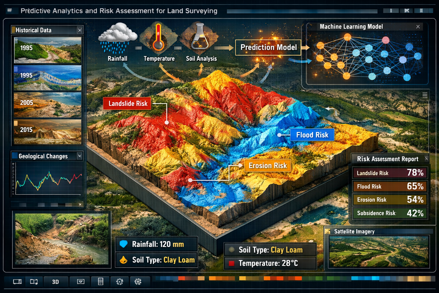
Perhaps the most groundbreaking application of AI and Machine Learning Revolutionizing Land Survey Data Analysis in 2026 lies in predictive analytics for risk assessment. AI models now analyze historical survey data combined with environmental factors to predict geological changes such as soil erosion, landslides, ground subsidence, and flooding[3][5]. This capability moves surveying beyond static mapping to anticipatory decision-making.
These predictive models incorporate vast amounts of data including:
- Historical geological surveys spanning decades
- Weather patterns and climate data showing precipitation trends
- Soil composition analysis identifying unstable areas
- Vegetation coverage changes indicating erosion patterns
- Groundwater level fluctuations affecting subsidence risk
- Seismic activity records for earthquake-prone regions
By processing these diverse data streams simultaneously, AI systems can identify risk patterns that would be impossible for human analysts to detect. For example, a machine learning model might identify that a particular combination of soil type, slope angle, and rainfall pattern creates a 75% probability of landslide occurrence within the next five years—information that is invaluable for urban planning and infrastructure development.
This predictive capability is particularly valuable for professionals conducting structural surveys or subsidence surveys, where understanding long-term geological trends is essential for accurate risk assessment.
Infrastructure Monitoring and Change Detection
AI's ability to monitor changes in structures and terrain over time provides essential data for environmental studies and construction monitoring[1][4]. Machine learning algorithms can compare survey data collected at different time intervals to detect even subtle changes in:
- Building settlement patterns indicating foundation issues
- Bridge displacement measurements showing structural stress
- Coastal erosion rates affecting waterfront properties
- Urban sprawl patterns for planning authorities
- Vegetation encroachment on infrastructure corridors
This continuous monitoring capability transforms surveying from periodic snapshots into ongoing surveillance systems. For clients requiring commercial building surveys, this means early detection of structural issues before they become critical problems.
The AI systems can automatically flag significant changes and alert relevant stakeholders, facilitating better communication with stakeholders through complex data presented in easily digestible formats[1][4]. Instead of technical reports filled with raw numbers, clients receive visual dashboards showing change over time, risk levels, and recommended actions.
Environmental Impact Assessment
Machine learning models excel at assessing environmental impacts by processing multiple variables simultaneously. These systems can evaluate how proposed developments might affect:
| Environmental Factor | AI Analysis Capability | Practical Application |
|---|---|---|
| Water Drainage | Predict flooding patterns based on topography and rainfall data | Site planning for new developments |
| Soil Stability | Assess load-bearing capacity and settlement risk | Foundation design optimization |
| Vegetation Impact | Model ecosystem disruption from land clearing | Environmental compliance planning |
| Air Quality | Predict pollution dispersion patterns | Industrial site selection |
| Wildlife Corridors | Identify critical habitat connections | Conservation-focused development |
These capabilities enable surveyors working on projects requiring building surveys to provide comprehensive environmental assessments that go far beyond traditional scope limitations.
Autonomous Systems and Advanced Technologies in Survey Operations
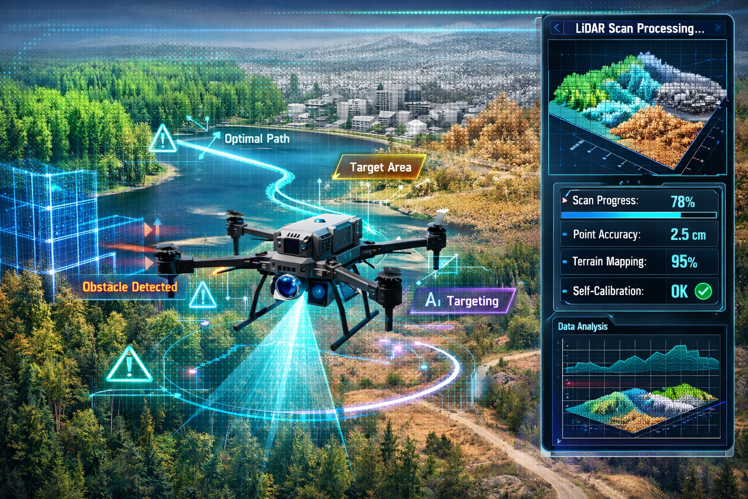
AI-Driven Drone Operations
The integration of AI models embedded in drones has created a new paradigm in aerial surveying. These autonomous systems can independently identify areas of interest, avoid obstacles, and adjust flight paths for optimal data collection[3]. The integration in unmanned aerial vehicles (UAVs) offers high-resolution, real-time imagery at a fraction of manned flight costs.
Modern survey drones in 2026 feature:
🚁 Autonomous navigation systems that plan optimal flight paths based on terrain complexity
🎯 Intelligent target recognition identifying specific features like boundary markers or infrastructure elements
⚡ Real-time data quality assessment ensuring complete coverage before leaving the site
🛡️ Advanced obstacle avoidance using multiple sensor fusion for safe operation in complex environments
🔋 Adaptive battery management optimizing flight patterns to maximize coverage per charge
These capabilities have made drone surveying accessible even in challenging environments where traditional methods would be dangerous or prohibitively expensive. The technology is particularly valuable for large-scale projects where chartered surveyors in London need to cover extensive urban areas efficiently.
LiDAR Technology and 3D Modeling Advances
AI-enhanced LiDAR technology generates highly detailed 3D terrain and infrastructure models, with AI capable of distinguishing between vegetation, buildings, and terrain features within LiDAR point clouds[3]. This automatic classification dramatically reduces human error and processing time that once made LiDAR data analysis a bottleneck in project workflows.
The machine learning algorithms powering modern LiDAR systems can:
- Automatically classify millions of points into categories like ground, vegetation, buildings, and water bodies
- Remove noise and artifacts from raw point cloud data
- Generate accurate digital elevation models (DEMs) without manual intervention
- Identify specific infrastructure elements like power lines, poles, and road markings
- Create detailed 3D building models including roof structures and architectural features
This automation has transformed LiDAR from a specialized tool requiring expert analysts into a mainstream surveying method accessible to general practitioners. Firms offering commercial property surveying services can now provide detailed 3D models as standard deliverables rather than premium add-ons.
Self-Calibrating Instruments and Error Correction
One of the most impressive advances in AI and Machine Learning Revolutionizing Land Survey Data Analysis in 2026 is the development of self-calibrating survey instruments. AI-enabled instruments can self-calibrate and automatically detect and correct anomalies in collected data[3], ensuring consistent accuracy throughout extended survey operations.
Machine learning algorithms identify when data points deviate significantly from surrounding values and adjust accordingly[3]. This automatic error detection works by:
- Establishing baseline patterns from initial high-quality measurements
- Continuously monitoring new data points against expected values
- Flagging statistical outliers that fall outside acceptable ranges
- Cross-referencing multiple sensors to identify instrument drift
- Applying automatic corrections based on known error patterns
This self-correction capability is particularly valuable for long-duration surveys where environmental conditions change throughout the day. Temperature variations, atmospheric pressure changes, and equipment settling can all introduce subtle errors that AI systems now detect and compensate for automatically.
For professionals conducting RICS building surveys, this means greater confidence in measurement accuracy and reduced need for redundant verification measurements.
Satellite Imagery Classification
Satellite imagery combined with AI algorithms provides advanced classification of terrain and land cover, enhancing accuracy of geospatial data used in environmental planning, urban development, and defense operations[3]. Modern machine learning models can analyze satellite imagery to identify:
- Land use categories (residential, commercial, agricultural, industrial)
- Vegetation types and health through multispectral analysis
- Water body boundaries and quality indicators
- Urban development patterns and growth trends
- Infrastructure networks including roads, railways, and utilities
This satellite-based analysis provides context for ground-based surveys, allowing surveyors to understand broader patterns and trends affecting specific project sites. The combination of satellite overview and detailed ground surveys creates a comprehensive understanding impossible with either method alone.
Operational Efficiency and Cost Benefits
Labor and Time Reduction
The automation enabled by AI has delivered substantial operational benefits to surveying firms. AI automates routine surveying processes and data processing, reducing survey time, labor costs, and project expenses[1][2][4]. Industry data from 2026 shows that firms implementing comprehensive AI systems have achieved:
- 40-60% reduction in data processing time
- 30-50% decrease in field survey duration
- 25-40% lower overall project costs
- 50-70% fewer data quality issues requiring rework
These efficiency gains allow surveyors to focus on higher-level analysis and decision-making rather than manual data processing[1][2][4]. Instead of spending hours manually measuring distances or calculating areas, professionals can now dedicate their expertise to interpreting results, providing strategic recommendations, and solving complex spatial problems.
For clients seeking survey pricing information, these efficiency improvements have translated into more competitive rates without sacrificing quality or comprehensiveness.
Improved Accuracy and Consistency
Beyond speed and cost savings, AI systems deliver superior accuracy and consistency compared to manual methods. Machine learning algorithms don't experience fatigue, distraction, or subjective interpretation—factors that can introduce variability in human-performed analysis.
The accuracy improvements manifest in several ways:
✓ Measurement precision increased through sensor fusion and statistical averaging
✓ Classification consistency with identical features always categorized the same way
✓ Error detection rates exceeding 95% for common data quality issues
✓ Reproducible results with identical inputs always producing identical outputs
✓ Comprehensive coverage with AI ensuring no areas are missed or overlooked
These quality improvements are particularly important for regulated work like RICS valuation surveys, where accuracy and defensibility are paramount.
Enhanced Client Communication
AI facilitates better communication with stakeholders through complex data presented in easily digestible formats[1][4]. Modern AI-powered visualization tools can transform raw survey data into:
📊 Interactive 3D models that clients can explore from any angle
📈 Trend analysis dashboards showing changes over time
🗺️ Intuitive map interfaces with layered information
📱 Mobile-friendly reports accessible from smartphones and tablets
🎨 Customized visualizations tailored to specific stakeholder needs
This improved communication reduces misunderstandings, speeds approval processes, and helps clients make more informed decisions. For firms providing homebuyer surveys, the ability to present findings in clear, visual formats helps buyers understand property conditions without requiring technical expertise.
Competitive Advantages in the Market
Surveying firms that have embraced AI technology in 2026 enjoy significant competitive advantages over those still relying on traditional methods. These advantages include:
Faster turnaround times enabling firms to accept time-sensitive projects that competitors cannot accommodate
Lower pricing while maintaining healthy margins through operational efficiency
Expanded service offerings including predictive analytics and continuous monitoring
Higher client satisfaction from improved accuracy and better communication
Talent attraction as skilled professionals prefer working with cutting-edge technology
Scalability to handle larger projects without proportional staff increases
These competitive factors have created a clear market division between AI-enabled firms and traditional practitioners, with the former capturing an increasing share of high-value projects.
Practical Applications Across Survey Types
Boundary and Property Surveys
For boundary surveys, AI brings unprecedented precision to property line determination. Machine learning algorithms can analyze historical deed descriptions, previous surveys, and current measurements to identify the most probable boundary locations with statistical confidence levels.
The technology is particularly valuable when dealing with:
- Conflicting historical records where AI can weigh evidence and suggest most likely interpretations
- Natural boundary markers like streams or tree lines that have shifted over time
- Adverse possession claims requiring analysis of long-term occupation patterns
- Easement determinations involving complex legal descriptions and physical features
AI systems can also predict potential boundary disputes by identifying areas where property descriptions are ambiguous or where physical evidence conflicts with legal descriptions, allowing proactive resolution before conflicts arise.
Topographic and Terrain Analysis
Topographic surveying has been transformed by AI's ability to process massive point cloud datasets and generate detailed terrain models. Modern systems can:
- Automatically generate contour lines at any desired interval
- Calculate cut-and-fill volumes for earthwork projects
- Identify drainage patterns and watershed boundaries
- Detect terrain anomalies that might indicate subsidence or instability
- Model slope stability for engineering applications
These capabilities make AI-powered topographic surveys invaluable for infrastructure planning, environmental assessment, and construction design. The technology enables chartered surveyors in Central London to efficiently survey complex urban environments with multiple elevation changes and underground infrastructure.
Construction Monitoring and Progress Tracking
AI excels at comparing survey data collected at different time intervals to track construction progress. Machine learning algorithms can:
🏗️ Compare as-built conditions against design specifications
📏 Measure excavation volumes and verify against project plans
🔍 Detect deviations from approved designs early in construction
⏱️ Track progress rates and predict completion timelines
💰 Verify quantities for payment applications and billing
This continuous monitoring capability helps project managers identify issues early, maintain schedules, and ensure quality compliance. For firms offering commercial building surveys, AI-powered monitoring provides clients with unprecedented visibility into project status.
Environmental and Conservation Surveys
Environmental surveying benefits enormously from AI's pattern recognition and predictive capabilities. Machine learning models can:
🌳 Map vegetation communities and track changes over time
💧 Monitor wetland boundaries and assess ecological health
🦅 Identify wildlife habitats and migration corridors
🌊 Track coastal erosion and predict future shoreline positions
♻️ Assess remediation effectiveness at contaminated sites
These capabilities support environmental compliance, conservation planning, and ecological restoration projects. The technology enables more comprehensive environmental assessments at lower costs than traditional manual survey methods.
Utility and Infrastructure Mapping
AI-powered surveys excel at identifying and mapping underground utilities and infrastructure networks. Advanced algorithms can:
- Interpret ground-penetrating radar data to locate buried utilities
- Correlate multiple sensor types for accurate depth and position determination
- Identify utility conflicts before excavation begins
- Map infrastructure networks including connections and flow directions
- Assess infrastructure condition through change detection analysis
This capability reduces the risk of costly utility strikes during construction and helps municipalities maintain accurate infrastructure records. The technology is particularly valuable in dense urban areas served by chartered surveyors in North London where underground utility congestion is common.
Challenges and Considerations for AI Implementation
Data Quality and Training Requirements
While AI systems offer tremendous capabilities, they require high-quality training data to function effectively. Machine learning models are only as good as the data they learn from, creating several challenges:
⚠️ Historical data limitations – Older surveys may lack the precision or completeness needed for effective AI training
⚠️ Data standardization issues – Inconsistent formats and classification schemes across different sources
⚠️ Regional variations – AI models trained in one geographic area may not perform well in different environments
⚠️ Edge case handling – Unusual situations not represented in training data may confuse AI systems
⚠️ Continuous updating needs – Models require regular retraining to maintain accuracy as conditions change
Surveying firms must invest in data quality management and ongoing model refinement to maximize AI benefits. This includes establishing standardized data collection protocols and maintaining comprehensive databases of verified survey results.
Professional Skill Development
The shift toward AI-powered surveying requires professionals to develop new skill sets beyond traditional surveying knowledge. Modern surveyors need competency in:
📚 Data science fundamentals including statistics and machine learning concepts
💻 Software proficiency with AI platforms and analysis tools
🔧 Algorithm understanding to interpret AI outputs and identify limitations
🎯 Quality assurance methods for validating AI-generated results
🤝 Interdisciplinary collaboration with data scientists and software developers
Professional organizations and educational institutions are adapting training programs to address these needs, but a skills gap currently exists in many markets. Firms investing in staff development gain competitive advantages through more effective AI utilization.
Regulatory and Professional Standards
The surveying profession operates under strict regulatory frameworks and professional standards that must evolve to accommodate AI technologies. Key considerations include:
- Professional liability for AI-generated errors or misinterpretations
- Certification requirements for AI-assisted survey work
- Data privacy regulations governing collection and use of geospatial information
- Quality assurance standards for automated data processing
- Documentation requirements for AI-assisted decision-making
Organizations like RICS (Royal Institution of Chartered Surveyors) are developing guidelines for AI use in surveying, but standards remain in development in many areas. Practitioners must stay informed about evolving requirements and maintain appropriate professional oversight of AI systems.
Technology Investment and ROI
Implementing comprehensive AI capabilities requires significant upfront investment in:
💰 Software licenses for AI platforms and analysis tools
🖥️ Computing hardware including high-performance processors and storage
📡 Sensor systems for autonomous data collection
📊 Data infrastructure for managing large datasets
👨🏫 Training programs for staff skill development
Smaller firms may struggle with these investment requirements, potentially creating market consolidation as larger firms gain technology advantages. However, cloud-based AI services and subscription models are making advanced capabilities more accessible to firms of all sizes.
The return on investment typically materializes through increased project capacity, faster turnaround times, and reduced labor costs. Most firms implementing comprehensive AI systems report positive ROI within 18-24 months of deployment.
Future Trends and Emerging Developments
Integration with Building Information Modeling (BIM)
The convergence of AI-powered surveying with Building Information Modeling represents a major trend for the coming years. This integration enables:
- Seamless data flow from survey to design to construction
- Automated clash detection between existing conditions and proposed designs
- Real-time model updates as construction progresses
- Lifecycle asset management using continuous survey monitoring
- Digital twin creation for facilities management
This integration is particularly valuable for complex projects requiring coordination between multiple disciplines and stakeholders. The technology supports more efficient project delivery and better long-term asset management.
Augmented Reality for Field Surveyors
Emerging augmented reality (AR) systems overlay AI-generated information onto real-world views, providing surveyors with enhanced situational awareness. AR applications include:
👓 Heads-up displays showing property boundaries and underground utilities
🎯 Real-time measurement visualization with instant calculations
🗺️ Navigation assistance to survey points and features of interest
⚡ Instant anomaly alerts when measurements deviate from expected values
📋 Digital data collection eliminating paper field notes
These AR tools improve field efficiency and reduce errors by providing immediate context and feedback. The technology is expected to become standard equipment for field surveyors within the next few years.
Quantum Computing Applications
While still in early stages, quantum computing promises to revolutionize certain aspects of survey data analysis. Potential applications include:
- Optimization problems like route planning and network design
- Pattern recognition in massive datasets beyond classical computing capabilities
- Simulation modeling for complex environmental predictions
- Cryptographic security for sensitive geospatial data
As quantum computing becomes more accessible, surveying firms may gain capabilities currently impossible with conventional technology.
Blockchain for Survey Records
Blockchain technology offers potential solutions for survey record management and verification:
🔗 Immutable records preventing unauthorized alterations
✅ Automated verification of surveyor credentials and certifications
📜 Smart contracts for automated service delivery and payment
🌐 Distributed storage eliminating single points of failure
🔍 Transparent audit trails for regulatory compliance
Several jurisdictions are piloting blockchain systems for land records and survey documentation, potentially transforming how survey data is stored, accessed, and verified.
Conclusion: Embracing the AI Revolution in Land Surveying
AI and Machine Learning Revolutionizing Land Survey Data Analysis in 2026 has fundamentally transformed the surveying profession from a field-based measurement discipline into a sophisticated data science practice. The integration of artificial intelligence has delivered measurable benefits including faster project completion, reduced costs, improved accuracy, and enhanced predictive capabilities that were impossible with traditional methods.
The technology enables surveyors to move beyond simple measurement and mapping toward anticipatory analysis and risk prediction. Machine learning algorithms can now forecast geological changes, optimize survey operations, and process massive datasets in real-time—capabilities that provide tremendous value to clients across residential, commercial, and infrastructure sectors.
However, successful AI implementation requires more than just technology adoption. Surveying firms must invest in data quality management, staff training, and ongoing system refinement to realize the full potential of these tools. Professional standards and regulatory frameworks continue evolving to address AI-specific considerations around liability, certification, and quality assurance.
Actionable Next Steps for Surveying Professionals
For surveying professionals and firms looking to leverage AI and machine learning technologies, consider these practical steps:
1. Assess Current Capabilities – Evaluate existing data collection and processing workflows to identify automation opportunities and efficiency bottlenecks.
2. Start with Targeted Applications – Rather than comprehensive system overhauls, begin with specific AI applications like automated point cloud classification or GPS route optimization where ROI is clearest.
3. Invest in Training – Develop staff competencies in data science fundamentals, AI platform operation, and quality assurance for automated systems.
4. Establish Data Standards – Implement consistent data collection and documentation protocols to support effective AI training and operation.
5. Partner with Technology Providers – Collaborate with AI platform vendors and consultants who understand surveying-specific requirements and challenges.
6. Monitor Industry Developments – Stay informed about evolving professional standards, regulatory requirements, and emerging technologies through professional organizations and continuing education.
7. Pilot Before Scaling – Test AI systems on smaller projects to validate performance and refine workflows before deploying across all operations.
The surveying firms that thrive in 2026 and beyond will be those that successfully integrate AI capabilities while maintaining the professional judgment, ethical standards, and client relationships that have always defined excellent surveying practice. Whether you need specialized services like boundary surveys, building surveys, or structural surveys, working with AI-enabled professionals ensures you receive the most accurate, efficient, and comprehensive service available.
The revolution in land survey data analysis is not coming—it is already here. The question is no longer whether to adopt AI technologies, but how quickly and effectively surveying professionals can integrate these powerful tools into their practice to deliver superior value to clients and maintain competitive advantage in an increasingly technology-driven marketplace.
References
[1] Content Ai Post – https://www.gonzalez-strength.com/content-ai-post/
[2] Ai Powered Surveying The Future Of Data Analysis In Land And Hydrographic Surveys – https://www.arcsurveyors.com/ai-powered-surveying-the-future-of-data-analysis-in-land-and-hydrographic-surveys/
[3] Ai Impact Analysis On Land Survey Equipment Industry – https://www.marketsandmarkets.com/ResearchInsight/ai-impact-analysis-on-land-survey-equipment-industry.asp
[4] Future Land Surveying 2026 – https://haller-blanchard.com/future-land-surveying-2026/
[5] The Future Of Land Surveying Technology And Upcoming Trends In 2026 – https://metricop.com/blogs/land-surveying/the-future-of-land-surveying-technology-and-upcoming-trends-in-2026
[6] Ai Machine Learning Impact Gps Data Processsing – https://www.baselineequipment.com/ai-machine-learning-impact-gps-data-processsing