In an era where precision defines success and errors translate directly into costly rework, the construction and surveying industries face mounting pressure to deliver flawless as-built documentation. Traditional measurement methods—tape measures, total stations, and manual drafting—no longer meet the demands of complex infrastructure projects requiring regulatory compliance and seamless digital workflows. Enter 3D Laser Scanning for Property Surveys: Creating Digital Twins to Streamline BIM Integration and Compliance, a transformative approach that captures buildings and structures with millimetre-level accuracy, generating comprehensive digital twins that feed directly into Building Information Modelling (BIM) software[1][2].
This technology revolution enables surveyors to document existing conditions faster, more accurately, and with far less disruption than conventional methods. By creating precise point cloud datasets that translate seamlessly into BIM environments, 3D laser scanning eliminates guesswork, reduces measurement errors, and ensures compliance with increasingly stringent regulatory standards. The result? Projects completed on time, within budget, and with documentation that stands up to the most rigorous audits.
Key Takeaways
- Millimetre-level accuracy: Modern 3D laser scanners capture millions of data points per second, achieving precision that manual methods cannot match, reducing errors and costly rework[2][4]
- Seamless BIM integration: Point cloud data converts directly into intelligent BIM models using software like Revit, creating as-built documentation that supports renovation planning and facility management[3]
- Regulatory compliance assurance: Digital twins provide comprehensive documentation that meets building codes, safety standards, and infrastructure regulations, reducing compliance risks
- Cost and time efficiency: Remote collaboration capabilities and reduced site visits lower project carbon footprints while accelerating project timelines by up to 40%[1][4]
- Future-proof asset management: Digital twins serve as living records that support ongoing maintenance, renovations, and facility operations throughout a building's lifecycle
Understanding 3D Laser Scanning Technology for Property Surveys
What Is 3D Laser Scanning?
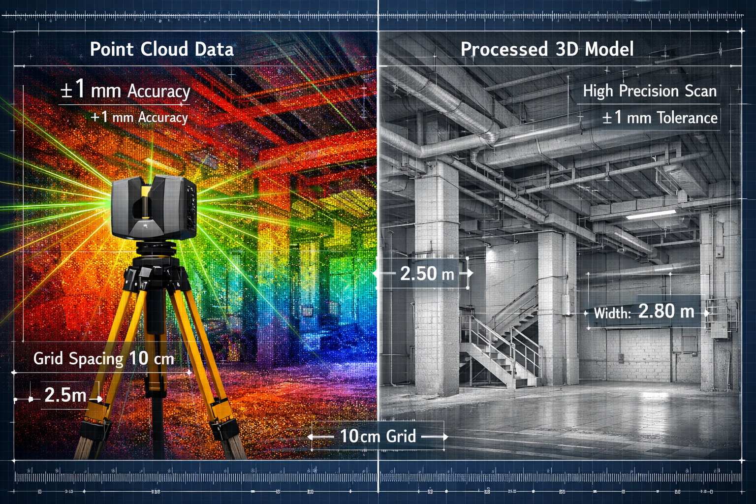
3D laser scanning represents a quantum leap in surveying technology. These sophisticated devices emit rapid pulses of laser light—often millions per second—that bounce off surfaces and return to the scanner. By measuring the time each pulse takes to return, the scanner calculates precise distances and creates a dense "point cloud" of millions of individual measurements[2].
Each point in this cloud contains three-dimensional coordinates (X, Y, Z) and often additional information like colour values and reflectivity data. When combined, these millions of points form an incredibly detailed digital representation of the physical environment—walls, ceilings, structural elements, mechanical systems, and architectural features all captured with extraordinary fidelity[6].
Key Technologies in Digital Twin Creation
Several complementary technologies work alongside 3D laser scanning to create comprehensive digital twins:
| Technology | Primary Use | Accuracy Level | Best Applications |
|---|---|---|---|
| 3D Laser Scanning | Interior and exterior capture | ±2-5mm | Complex buildings, industrial facilities |
| Total Stations | Precise control points | ±1-2mm | Boundary surveys, structural monitoring |
| Photogrammetry | Texture and visual detail | ±5-10mm | Heritage buildings, facade documentation |
| UAV/Drone Imaging | Large-scale site capture | ±10-50mm | Infrastructure, roof surveys, site planning |
These technologies often work in concert. For instance, drone surveys might capture a building's exterior and surrounding site, while terrestrial laser scanning documents interior spaces with precision[1][2].
How Laser Scanning Differs from Traditional Survey Methods
Traditional surveying relies on manual measurements taken at discrete points—a surveyor might measure room dimensions, ceiling heights, and structural features one at a time. This approach has several limitations:
- ⚠️ Limited data density: Only specific points are measured, potentially missing critical details
- ⏱️ Time-intensive: Complex buildings require days or weeks of on-site measurement
- 📏 Human error: Manual measurements introduce inconsistencies and mistakes
- 📋 Incomplete documentation: Difficult to capture complex geometries and irregular features
In contrast, 3D laser scanning captures everything within the scanner's field of view. A single scan position might record millions of measurements in minutes, documenting not just walls and floors but pipes, conduits, structural members, and architectural details that would take hours to measure manually[4][6].
This comprehensive data capture proves invaluable for commercial building surveys where understanding existing conditions thoroughly is essential for renovation planning and compliance verification.
3D Laser Scanning for Property Surveys: Creating Digital Twins to Streamline BIM Integration and Compliance Workflows
The Digital Twin Concept in Property Surveying
A digital twin goes beyond a simple 3D model—it's a comprehensive virtual replica of a physical asset that serves as a single source of truth throughout a building's lifecycle[2][5]. In property surveying, digital twins created from laser scan data provide:
- As-built accuracy: Precise documentation of existing conditions, not idealized design intent
- Spatial intelligence: Measurements, volumes, areas, and clearances available on-demand
- Visual context: Photorealistic representation that stakeholders can navigate virtually
- Change detection: Baseline for monitoring structural movement, settlement, or deterioration
For infrastructure projects, these digital twins become invaluable assets. Engineers can analyze clearances for new mechanical systems, architects can plan renovations with confidence in existing conditions, and facility managers can maintain accurate records of building modifications over time[5].
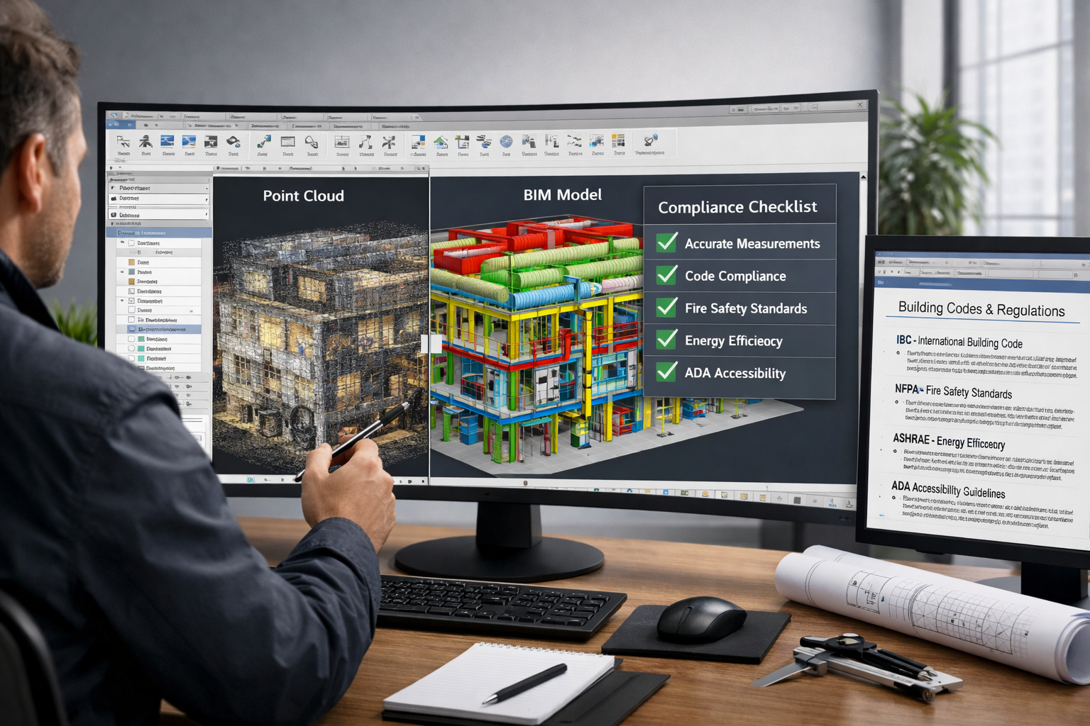
Processing Point Cloud Data into BIM Models
The journey from raw laser scan data to functional BIM model involves several critical steps:
Step 1: Data Acquisition and Registration
Multiple scan positions are required to capture a complete building. Each scan creates a separate point cloud that must be "registered" (aligned) with others to create a unified dataset. Modern software automates much of this process using overlapping features and target spheres placed throughout the space[7].
Step 2: Point Cloud Cleaning and Optimization
Raw scan data includes unwanted elements—people, furniture, temporary equipment. Surveyors clean the point cloud, removing extraneous data while preserving architectural and structural elements relevant to the project[7].
Step 3: BIM Model Creation
This critical phase transforms point cloud data into intelligent BIM objects. Using software like Autodesk Revit, surveyors trace walls, floors, ceilings, and structural elements directly from the point cloud. The result is a parametric model where each element contains not just geometry but metadata—material properties, construction specifications, and performance characteristics[3].
For RICS commercial building surveys, this BIM model becomes the foundation for detailed condition assessments and compliance reporting.
Step 4: Quality Assurance and Validation
Before delivery, models undergo rigorous quality checks:
- ✅ Dimensional accuracy: Comparing model measurements against point cloud data
- ✅ Completeness: Ensuring all required building elements are modeled
- ✅ Metadata verification: Confirming that object properties align with project requirements
- ✅ Clash detection: Identifying conflicts between building systems
Software Solutions for Scan-to-BIM Workflows
Several software platforms facilitate the conversion of point cloud data to BIM models:
Point Cloud Processing:
- Autodesk ReCap Pro
- Faro Scene
- Leica Cyclone
BIM Modeling:
- Autodesk Revit (industry standard for architectural BIM)
- ArchiCAD
- Bentley MicroStation
Specialized Scan-to-BIM Tools:
- ClearEdge3D EdgeWise (automated feature extraction)
- PointCab (rapid modeling from point clouds)
- Reconstructor (Leica's modeling solution)
These tools increasingly incorporate artificial intelligence and machine learning to automate feature recognition, dramatically reducing the time required to create accurate BIM models from scan data[3].
Ensuring Regulatory Compliance Through Precise As-Built Documentation
Building Code Compliance and Digital Verification
Regulatory compliance represents one of the most compelling applications for 3D Laser Scanning for Property Surveys: Creating Digital Twins to Streamline BIM Integration and Compliance. Building codes and standards impose strict requirements on dimensions, clearances, accessibility, and safety features. Traditional verification methods rely on spot-checks and manual measurements—approaches that can miss critical non-compliances.
Digital twins created from laser scan data enable comprehensive compliance verification:
Fire Safety Compliance:
- Verify corridor widths meet minimum egress requirements
- Confirm fire door clearances and swing directions
- Document sprinkler head coverage and spacing
- Validate emergency exit signage placement
Accessibility Standards:
- Measure ramp slopes and landing dimensions
- Verify doorway widths and maneuvering clearances
- Document accessible route continuity
- Confirm restroom fixture heights and clearances
Structural Load Paths:
- Document beam sizes and column spacing
- Verify floor-to-ceiling heights for code compliance
- Measure slab thicknesses and structural depths
For property certification processes, this comprehensive documentation provides auditable evidence of compliance, reducing liability and streamlining approval processes.
Infrastructure Project Compliance Requirements
Large infrastructure projects—bridges, tunnels, railways, utilities—face even more stringent regulatory oversight. These projects must comply with national standards, environmental regulations, and safety protocols that demand precise documentation[5].
3D laser scanning addresses these requirements by:
🏗️ Baseline Documentation: Capturing existing conditions before construction begins, providing indisputable records for schedule of condition reporting
📊 Progress Monitoring: Regular scans document construction progress, verifying that work matches approved plans and specifications
🔍 Quality Control: Comparing as-built conditions against design models to identify deviations before they become costly problems
🌍 Environmental Compliance: Documenting site conditions to verify environmental protection measures and restoration requirements
Reducing Errors and Rework Costs
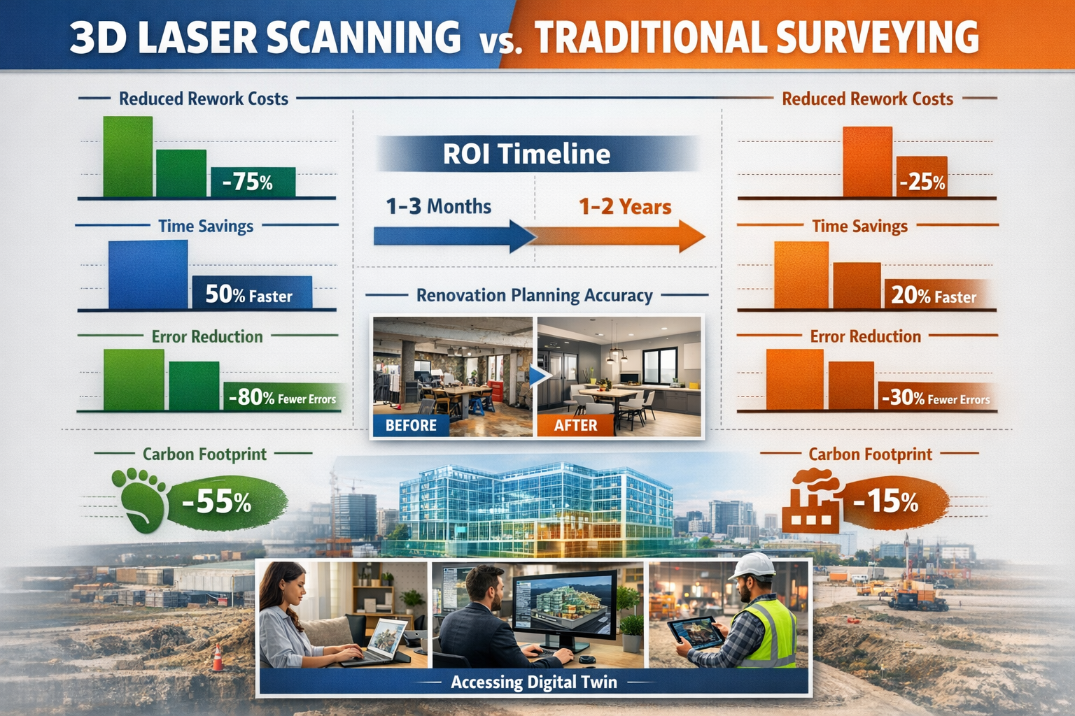
Construction rework—correcting mistakes discovered during or after construction—costs the industry billions annually. Studies suggest that rework accounts for 5-15% of total project costs, with measurement errors and inadequate documentation among the leading causes[4].
Digital twins created through 3D laser scanning dramatically reduce these costs:
"By providing millimetre-accurate as-built documentation, laser scanning eliminates the guesswork that leads to design conflicts, fabrication errors, and installation problems. Projects using scan-to-BIM workflows report rework reductions of 30-50%."[4]
Specific error-reduction benefits include:
- Clash avoidance: Identifying conflicts between new systems and existing conditions before fabrication
- Precise fabrication: Providing exact dimensions for custom components and assemblies
- Installation verification: Confirming that installed systems match design intent
- Change order reduction: Minimizing costly mid-project design changes due to unforeseen conditions
For commercial property surveying projects involving renovations or fit-outs, these benefits translate directly to bottom-line savings and faster project delivery.
Practical Applications Across Property Types and Project Phases
Heritage Buildings and Conservation Projects
Historic structures present unique challenges—complex geometries, irregular features, and the need to preserve original fabric while meeting modern codes. Traditional surveying struggles to capture ornate plasterwork, curved walls, and intricate architectural details that define heritage buildings.
3D laser scanning excels in these applications:
- Non-contact measurement: No physical contact with fragile surfaces or finishes
- Complete documentation: Capturing every detail for conservation records
- Restoration planning: Providing precise templates for replicating damaged elements
- Structural analysis: Creating detailed models for engineering assessments
The resulting digital twins serve as permanent archives, preserving a building's condition at a specific point in time—invaluable for future conservation efforts and historical research[6].
Industrial Facilities and Process Plants
Industrial environments—refineries, manufacturing plants, power stations—contain dense concentrations of piping, equipment, and structural systems. Documenting these facilities manually is time-consuming, dangerous, and often incomplete.
Laser scanning transforms industrial surveying:
✅ Safety improvement: Reducing time personnel spend in hazardous areas
✅ Operational continuity: Scanning during normal operations with minimal disruption
✅ Maintenance planning: Creating accurate models for equipment replacement and upgrades
✅ Retrofit design: Providing precise spatial data for new system installations
For facilities requiring structural engineering assessments, point cloud data enables detailed analysis of load-bearing elements and structural integrity.
Commercial Renovations and Tenant Fit-Outs
Commercial building renovations demand precise understanding of existing conditions. Landlords, tenants, and design teams need accurate information about ceiling heights, column locations, mechanical systems, and structural constraints.
Scan-to-BIM workflows streamline these projects:
- Pre-lease surveys: Documenting space conditions for prospective tenants
- Design development: Providing accurate base models for fit-out design
- Coordination: Ensuring new systems fit within existing spatial constraints
- As-built delivery: Creating final documentation for facility management
This approach proves particularly valuable for dilapidation surveys, where precise documentation of existing conditions protects both landlords and tenants from disputes.
Multi-Family Residential and Mixed-Use Developments
Large residential and mixed-use projects benefit from laser scanning during multiple project phases:
Design Phase:
- Site surveys capturing existing buildings and topography
- Feasibility studies analyzing development potential
- Zoning compliance verification
Construction Phase:
- Quality control monitoring construction progress
- Verifying dimensional accuracy of structural elements
- Documenting conditions for warranty and liability protection
Handover Phase:
- Creating as-built BIM models for facility management
- Providing unit-specific documentation for homeowner records
- Supporting building certification and regulatory approvals
The comprehensive documentation supports RICS building surveys and provides property owners with valuable asset records.
Implementing 3D Laser Scanning in Your Survey Practice
Equipment Selection and Investment Considerations
Choosing appropriate laser scanning equipment depends on project types, accuracy requirements, and budget:
Entry-Level Solutions (£15,000-£35,000):
- Suitable for small commercial projects and residential surveys
- Range: 10-30 meters
- Accuracy: ±5-10mm
- Scan time: 3-5 minutes per position
Mid-Range Professional Systems (£35,000-£80,000):
- Ideal for most commercial and industrial applications
- Range: 30-100 meters
- Accuracy: ±2-5mm
- Scan time: 1-3 minutes per position
- Integrated photography for colorized point clouds
High-End Survey-Grade Scanners (£80,000-£150,000+):
- Required for large infrastructure and precision applications
- Range: 100-350 meters
- Accuracy: ±1-2mm
- Scan time: <1 minute per position
- Advanced features: long-range capability, HDR imaging, automated workflows
Beyond the scanner itself, budget for:
- 💻 Processing workstations: High-performance computers with powerful graphics cards
- 📦 Software licenses: Point cloud processing and BIM modeling tools
- 🎒 Accessories: Tripods, targets, batteries, transport cases
- 📚 Training: Operator certification and software proficiency development
Training and Skill Development
Effective use of 3D laser scanning requires developing new competencies:
Technical Skills:
- Scanner operation and field procedures
- Point cloud registration and processing
- BIM modeling from point cloud data
- Quality control and accuracy verification
Professional Knowledge:
- Understanding when scanning is appropriate versus traditional methods
- Scoping projects accurately for time and cost estimation
- Communicating scan deliverables to clients and stakeholders
- Managing data storage and archiving for large datasets
Many manufacturers offer certification programs, while professional organizations provide continuing education focused on reality capture technologies. Investing in training ensures your team maximizes the technology's potential while avoiding costly mistakes.
Project Planning and Execution Best Practices
Successful scan-to-BIM projects follow systematic workflows:
Pre-Survey Planning:
- Define project scope and deliverables clearly
- Identify accuracy requirements and quality standards
- Coordinate site access and safety requirements
- Plan scan positions to ensure complete coverage
Field Data Acquisition:
- Establish control network for large projects
- Place registration targets strategically
- Execute scanning according to planned positions
- Perform on-site quality checks of scan data
- Document any site conditions affecting data quality
Post-Processing and Modeling:
- Register scans into unified point cloud
- Clean and optimize data for modeling
- Create BIM model according to project specifications
- Perform quality assurance checks
- Deliver final models and documentation
Documentation and Archiving:
- Maintain organized file structures for point cloud and model data
- Archive raw scan data for future reference
- Provide clear documentation of modeling assumptions and limitations
- Deliver user guides for accessing and using digital twins
Cost-Benefit Analysis: ROI of 3D Laser Scanning Implementation
Quantifying Direct Cost Savings
Organizations implementing 3D laser scanning typically see measurable returns within 12-24 months:
Time Savings:
- Traditional survey of medium commercial building: 5-10 days
- Laser scan survey of same building: 1-2 days
- Time reduction: 60-80%
Labor Cost Reduction:
- Fewer personnel required on-site
- Reduced return visits for missing measurements
- Faster deliverable production
- Labor cost reduction: 40-60%
Rework Avoidance:
- Fewer design conflicts requiring correction
- Reduced change orders due to unforeseen conditions
- Minimized installation errors
- Rework cost reduction: 30-50%[4]
Indirect Benefits and Competitive Advantages
Beyond direct cost savings, laser scanning provides strategic advantages:
🎯 Market Differentiation: Offering advanced technology services distinguishes your practice from competitors still using traditional methods
📈 Project Scalability: Ability to handle larger, more complex projects that would be impractical with manual surveying
🤝 Client Confidence: Delivering precise, comprehensive documentation builds trust and encourages repeat business
🌱 Sustainability: Reduced site visits and remote collaboration lower carbon footprints, appealing to environmentally conscious clients[1]
Carbon Footprint Reduction and Sustainability
The construction industry faces increasing pressure to reduce environmental impact. Digital twins created through 3D laser scanning contribute to sustainability goals:
- Reduced travel: Fewer site visits mean less transportation-related emissions
- Remote collaboration: Teams can review and analyze digital twins without traveling to sites
- Material optimization: Precise measurements minimize material waste from fabrication errors
- Building lifecycle efficiency: Digital twins support energy modeling and operational optimization
Projects can reduce their carbon footprint by 20-30% through efficient scanning workflows and remote collaboration enabled by digital twins[1].
Future Trends in 3D Laser Scanning and Digital Twin Technology
Artificial Intelligence and Automated Feature Extraction
The next frontier in scan-to-BIM workflows involves AI-powered automation. Machine learning algorithms are increasingly capable of:
- Automatic object recognition: Identifying walls, doors, windows, and building systems from point clouds
- Intelligent modeling: Creating BIM objects automatically with minimal human intervention
- Anomaly detection: Flagging potential structural issues or code violations
- Predictive maintenance: Analyzing scan data to identify developing problems before failure
These capabilities promise to reduce modeling time by 50-70%, making scan-to-BIM workflows even more cost-effective[3].
Real-Time Scanning and Mobile Platforms
Traditional tripod-mounted scanners require stationary setups at each scan position. Emerging technologies offer greater flexibility:
Handheld Mobile Scanners:
- Walk-through scanning for rapid data capture
- Ideal for complex spaces with many rooms
- Lower accuracy but faster coverage
Wearable Scanning Systems:
- Backpack-mounted scanners for large facilities
- Continuous scanning while walking
- Automated data processing and registration
Robotic and Autonomous Scanning:
- Unmanned ground vehicles (UGVs) with integrated scanners
- Automated scanning of hazardous or inaccessible areas
- Integration with building security and monitoring systems
Integration with IoT and Smart Building Systems
Digital twins are evolving from static documentation to dynamic, living models that integrate real-time data from building systems:
- Sensor integration: Incorporating temperature, humidity, occupancy, and energy consumption data
- Predictive analytics: Using historical data to forecast maintenance needs and system failures
- Operational optimization: Adjusting building systems based on actual usage patterns
- Emergency response: Providing first responders with detailed building information and real-time conditions
This convergence of reality capture and operational data transforms digital twins into comprehensive facility management platforms that support buildings throughout their entire lifecycle[5].
Conclusion: Embracing Digital Transformation in Property Surveying
3D Laser Scanning for Property Surveys: Creating Digital Twins to Streamline BIM Integration and Compliance represents more than a technological upgrade—it's a fundamental transformation in how surveyors document, analyze, and communicate information about the built environment. The precision, efficiency, and comprehensive documentation that laser scanning provides have become essential for meeting the demands of modern construction projects, regulatory compliance requirements, and client expectations.
The benefits are clear and measurable: reduced errors, lower rework costs, faster project delivery, and enhanced regulatory compliance. For surveying practices willing to invest in equipment, training, and process development, the return on investment materializes quickly through competitive advantages, expanded service offerings, and improved project outcomes.
Actionable Next Steps for Implementation
Ready to integrate 3D laser scanning into your practice? Follow these steps:
- Assess your market: Identify project types and clients that would benefit most from scan-to-BIM services
- Start small: Consider partnering with scanning specialists for initial projects before investing in equipment
- Invest in training: Ensure your team develops both technical proficiency and professional expertise
- Develop workflows: Create standardized processes for data acquisition, processing, and deliverable production
- Build partnerships: Establish relationships with BIM consultants, architects, and engineers who value precise as-built documentation
- Market your capabilities: Communicate your advanced technology services to existing and prospective clients
Whether you're conducting chartered property inspections or managing complex infrastructure projects, 3D laser scanning and digital twin technology provide the precision, efficiency, and documentation quality that define professional excellence in 2026.
The future of property surveying is digital, precise, and integrated. Organizations that embrace these technologies today position themselves as leaders in an industry undergoing rapid transformation. The question is not whether to adopt 3D laser scanning, but how quickly you can integrate it into your practice to serve clients better, reduce project risks, and build a sustainable competitive advantage.
For expert guidance on implementing advanced surveying technologies for your next project, get a quote from experienced professionals who understand both traditional surveying principles and cutting-edge digital workflows.
References
[1] Measured Building – https://terrameasurement.com/measured-building/
[2] Digital Twin – https://arrival3d.com/services/digital-twin/
[3] 3d Scanning Bim Residential Project – https://geomaus.com/3d-scanning-bim-residential-project/
[4] Benefits Of 3d Laser Scanning – https://eagle-eac.com/benefits-of-3d-laser-scanning/
[5] Reality Capture And Digital Twins – https://www.mgmclaren.com/keyservices/survey-and-mapping/reality-capture-and-digital-twins/
[6] 3d Laser Scanning Mastery Techniques And Benefits For Modern Property Surveys – https://nottinghillsurveyors.com/blog/3d-laser-scanning-mastery-techniques-and-benefits-for-modern-property-surveys
[7] 3d Laser Scanning The Process Deliverables – https://terrainsurveys.co.uk/news-and-media/3d-laser-scanning/3d-laser-scanning-the-process-deliverables