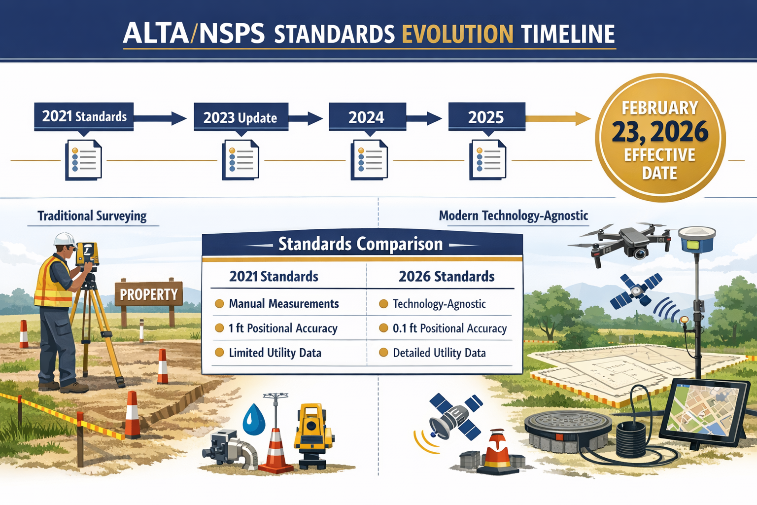
The land surveying profession stands at a pivotal moment. After more than three years of collaborative development, the American Land Title Association (ALTA) and National Society of Professional Surveyors (NSPS) have unveiled comprehensive updates to their land title survey standards that will fundamentally reshape how surveyors, title insurers, and real estate professionals approach property documentation. The 2026 ALTA/NSPS Land Title Survey Standards: Key Updates and Compliance Guide represents the most significant evolution in surveying practices since the last major revision, introducing changes that eliminate administrative burdens while enhancing technical precision.
For surveyors navigating the transition from 2021 standards, understanding these revisions is not merely academic—it's essential for maintaining compliance, avoiding costly errors, and delivering value to clients in an increasingly complex real estate landscape. This comprehensive guide breaks down every critical change, from the elimination of adjoining property deed requirements to the revolutionary technology-agnostic framework that embraces emerging tools like drones and artificial intelligence.
Key Takeaways
- 📅 February 23, 2026 marks the official effective date for the new standards, with specific transition rules for contracts executed before and after this date
- 📊 Relative Positional Precision (RPP) definitions have been clarified to improve understanding among non-surveyor stakeholders
- 🏘️ Evidence of possession documentation must now be noted along the entire property perimeter, regardless of distance from boundary lines
- ⚡ Utility identification requirements have been expanded with clear distance thresholds (10 feet for poles, 5 feet for other features)
- 🚁 Technology-agnostic standards eliminate the need to specify individual surveying tools, allowing professional adoption of drones, LiDAR, and AI within established practices
Understanding the 2026 ALTA/NSPS Land Title Survey Standards: Key Updates and Compliance Guide
What Are ALTA/NSPS Standards?
The ALTA/NSPS Land Title Survey Standards represent the gold standard for property boundary surveys in commercial real estate transactions across the United States. These standards establish uniform requirements that ensure title insurance companies, lenders, and property buyers receive consistent, reliable information about property boundaries, improvements, easements, and potential encumbrances.
Unlike residential surveys that may vary significantly by state or locality, ALTA/NSPS surveys provide a nationally recognized framework that facilitates interstate commerce and reduces ambiguity in complex real estate transactions. Similar to how building surveys provide comprehensive property assessments, ALTA/NSPS surveys deliver detailed boundary and title-related information critical for commercial transactions.
Development Timeline and Adoption
The Joint ALTA/NSPS Work Group invested over three years developing the 2026 standards through extensive collaboration among surveyors, title insurance professionals, attorneys, and real estate practitioners.[2] This thorough development process ensured that the updates address real-world challenges while maintaining the technical rigor essential for accurate property documentation.
The standards were officially adopted in October 2025 and take effect on February 23, 2026, replacing the 2021 standards that have governed land title surveys for the past five years.[1][2] This timeline provides surveyors and related professionals with several months to familiarize themselves with the changes and adjust their workflows accordingly.
Major Technical Changes in the 2026 ALTA/NSPS Land Title Survey Standards
Revised Relative Positional Precision Definition
Perhaps the most significant technical modification involves the updated definition of Relative Positional Precision (RPP)—a statistical measurement that determines how accurately surveyors locate property boundaries and other critical features.[1]
What is RPP? Relative Positional Precision represents the uncertainty value showing the relationship between two points on a survey. It's expressed as a distance (typically in feet or meters) and indicates the confidence level that surveyed points are positioned accurately relative to each other.
The 2026 standards provide clarified explanations specifically designed for stakeholders less familiar with statistical surveying metrics, including:
- Title insurance underwriters
- Real estate attorneys
- Commercial lenders
- Property developers
This enhanced clarity reduces misunderstandings and helps non-surveyor professionals better evaluate survey quality and reliability. The revision doesn't fundamentally change how RPP is calculated or applied, but rather improves communication about this critical quality metric.
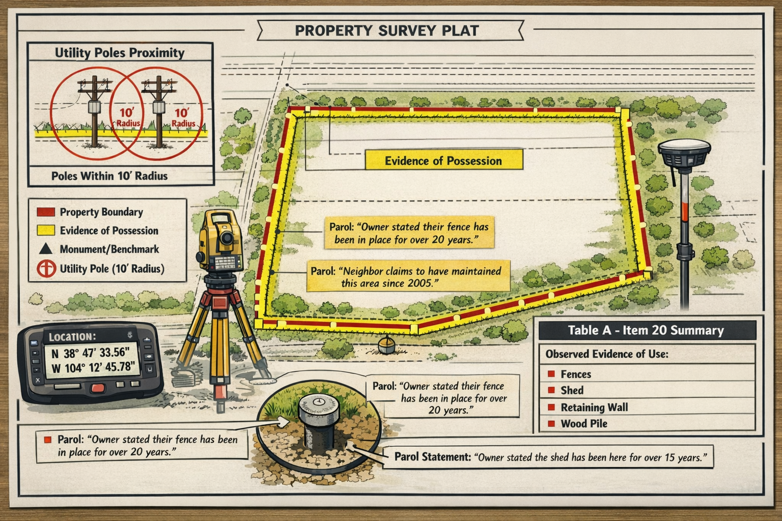
Expanded Evidence of Possession Documentation
One of the most practical changes addresses a persistent source of confusion in the 2021 standards. The new requirements mandate that evidence of possession or occupation along the property perimeter be noted "regardless of proximity to boundary lines."[1][2]
Previous Standard (2021): Surveyors interpreted requirements inconsistently, with many believing evidence of possession only needed documentation if within 5 feet of boundary lines.
New Standard (2026): All evidence of possession along the property perimeter must be documented, eliminating the proximity threshold entirely.
What constitutes evidence of possession?
- 🏗️ Fences and walls
- 🚗 Paved areas and parking lots
- 🏢 Building overhangs and projections
- 🌳 Landscaping features indicating occupancy
- 📦 Storage areas and equipment
- 🚪 Gates and access controls
This change ensures that title insurers and property buyers receive comprehensive information about how property is actually used and occupied, regardless of whether possession indicators fall precisely on boundary lines. Much like how structural surveys document all significant building elements, the expanded possession documentation provides a complete picture of property occupation.
Enhanced Utility Feature Identification
The 2026 standards introduce clearer distance thresholds for utility feature documentation, eliminating previous ambiguity:[1]
| Utility Feature Type | Documentation Requirement |
|---|---|
| Utility Poles | On property or within 10 feet of property boundaries |
| Other Utility Features | On property or within 5 feet of property boundaries |
| Underground Utilities | As observable or indicated by surface features |
Other utility features include:
- Transformer boxes
- Meter installations
- Junction boxes
- Utility pedestals
- Communication equipment
- Service connections
This standardized approach provides consistency across surveys and helps identify potential conflicts with property development plans early in the transaction process. Utility conflicts represent one of the most common sources of title insurance claims, making this enhanced documentation particularly valuable.
Parol Statement Notation Requirements
A notable addition to the 2026 standards requires surveyors to note verbal or parol statements made by landowners or occupants pertaining to property title.[1] This requirement improves transparency around informal title claims that might not appear in recorded documents but could affect property rights.
Examples of parol statements requiring notation:
- Claims of prescriptive easements ("We've always used that driveway")
- Assertions of adverse possession ("This fence has been here for 30 years")
- Verbal agreements about property lines ("The previous owner said the line runs along the tree line")
- Statements about unrecorded rights ("They gave us permission to park here")
While these statements don't constitute legal evidence of title, their documentation alerts title insurers and attorneys to potential issues requiring further investigation. This proactive approach can prevent disputes and clarify title issues before transactions close.
Administrative and Workflow Changes in the 2026 ALTA/NSPS Land Title Survey Standards: Key Updates and Compliance Guide
Eliminated Adjoin Property Deed Requirement
One of the most significant workflow improvements involves the elimination of the requirement that title insurers provide copies of deeds of adjoining properties to surveyors.[2]
Why this matters:
Under the 2021 standards, title companies were required to furnish surveyors with recorded deeds for all properties adjoining the surveyed parcel. This requirement created administrative burdens for title insurers and often delayed survey commencement while documents were gathered.
The 2026 change:
This requirement has been completely removed, streamlining the information exchange process and allowing surveys to commence more quickly. Surveyors still have access to adjoining property information through public records, but the formal requirement for title companies to provide these documents is eliminated.
This change recognizes that modern surveyors have direct access to digital land records in most jurisdictions, making the formal deed provision requirement redundant. The elimination reduces administrative costs and accelerates transaction timelines without compromising survey quality.
Technology-Agnostic Standards Framework
Perhaps the most forward-looking change involves the adoption of a technology-agnostic framework that references "practices generally recognized as acceptable by the surveying profession" rather than specifying individual surveying tools and methods.[1][2]
Previous Approach: Standards required periodic updates to specifically address new technologies like drones, LiDAR, and artificial intelligence applications.
New Approach: Standards establish professional practice expectations without prescribing specific technologies, allowing surveyors to employ emerging tools within established quality frameworks.
Technologies now clearly permitted under professional practice standards:
- 🚁 Drone-based surveying for aerial imagery and photogrammetry
- 📡 LiDAR scanning for detailed topographic and structural data
- 🤖 Artificial intelligence for data processing and feature identification
- 📱 Mobile mapping systems for efficient data collection
- 🛰️ Advanced GPS/GNSS for positioning and control networks
This framework ensures the standards remain relevant and current as surveying technology continues to evolve rapidly. Surveyors can adopt innovations that improve accuracy, efficiency, and safety without waiting for standards revisions to explicitly authorize specific tools. Similar to how drone surveys have revolutionized building inspections, emerging technologies are transforming land surveying practices.
New Optional Table A Item 20
The 2026 standards introduce Optional Table A Item 20, which provides surveyors the ability to create a summary table on the survey plat showing physical conditions and potential encroachments with references to their locations.[1]
Table A represents the section of ALTA/NSPS standards where clients can request additional survey elements beyond the minimum requirements. The new Item 20 offers a structured way to communicate complex information clearly.
Benefits of Item 20:
✅ Enhanced client communication through organized presentation of critical information
✅ Risk reduction by highlighting potential issues prominently
✅ Improved decision-making with at-a-glance access to key survey findings
✅ Reduced liability through clear documentation of observed conditions
Example summary table elements:
- Building setback violations
- Fence encroachments
- Utility conflicts
- Easement impacts
- Access issues
- Drainage concerns
This optional item recognizes that survey plats can become visually complex, and a summary table helps clients quickly identify the most critical information affecting their transaction decisions.
Imagery-Based Surveying Clarification
Table A Item 15 received important revisions that explicitly permit imagery rather than ground surveying for certain features, with specific requirements to maintain survey accuracy.[1][2]
Requirements for imagery-based surveying:
- Written agreement between surveyor and client specifying which features will be documented through imagery
- Specific documentation of imagery sourcing (date, resolution, provider)
- Professional judgment that imagery quality is sufficient for intended purpose
- Clear notation on survey plat indicating imagery-based documentation
This clarification acknowledges that modern aerial and satellite imagery often provides sufficient detail for documenting certain property features, particularly in large-scale surveys where ground verification of every feature would be prohibitively expensive.
Features commonly documented through imagery:
- Building footprints
- Paved areas
- Vegetation patterns
- Topographic features
- Site improvements
- Access routes
The requirement for written agreement and documentation ensures transparency and prevents misunderstandings about survey methodology.
Compliance Requirements and Transition Rules for the 2026 ALTA/NSPS Land Title Survey Standards
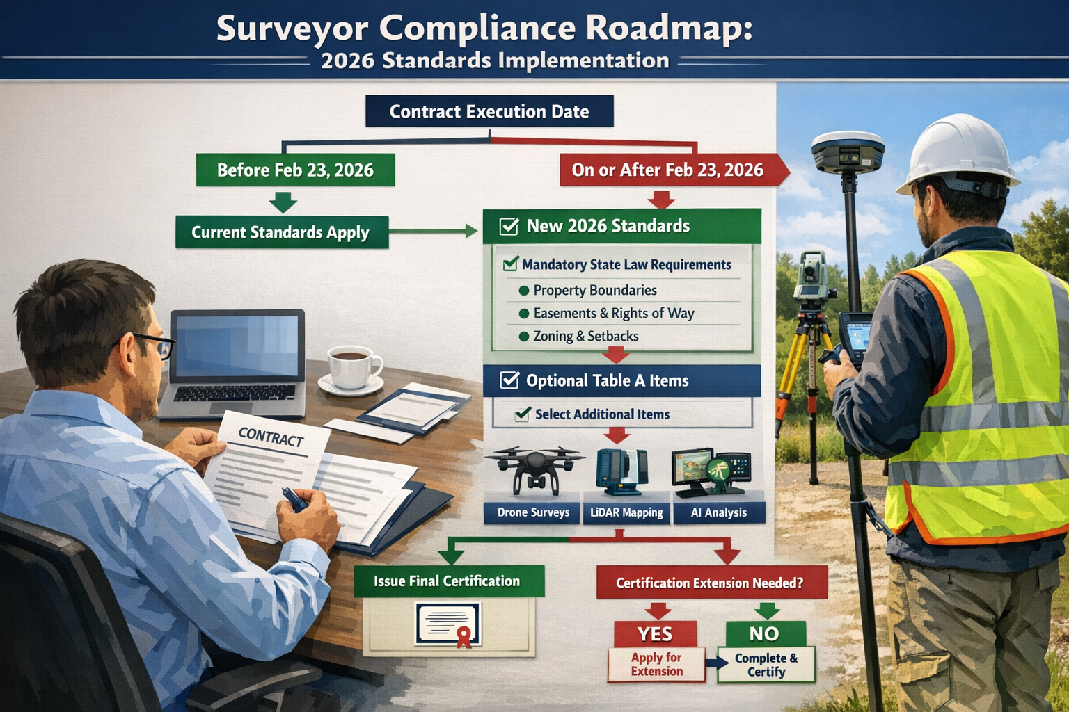
Critical Effective Date: February 23, 2026
Understanding the transition timeline is essential for surveyors, title companies, and real estate professionals managing transactions that span the standards changeover.[2]
Contracts Executed BEFORE February 23, 2026:
- ✅ May continue under 2021 standards even if survey completion occurs after the effective date
- ✅ Provides flexibility for transactions already in progress
- ✅ Prevents disruption of ongoing projects
- ⚠️ Must be documented that contract preceded effective date
Contracts Executed ON OR AFTER February 23, 2026:
- ✅ Must comply with 2026 standards with limited exceptions
- ✅ Applies regardless of when survey work commenced
- ✅ Contract execution date controls, not survey start date
- ⚠️ No grandfathering for new contracts after effective date
This transition framework balances the need for updated standards with practical recognition that real estate transactions often span months and involve multiple parties with contractual obligations established well before survey commencement.
Mandatory State Law Requirements
The 2026 standards explicitly acknowledge that administrative rules may require recording of the plat or map and allow certification extensions to successors and assigns of lenders if requested.[1]
Critical clarification: The Work Group emphasized that mandatory requirements under state law remain non-negotiable, including:
- Boundary monumenting requirements
- Professional licensure standards
- Recording and filing requirements
- Certification language
- Seal and signature protocols
- Minimum technical standards exceeding ALTA/NSPS requirements
Important principle: Optional Table A items become mandatory when required by applicable state or local law, regardless of whether clients specifically request them.[2]
This acknowledgment prevents conflicts between national ALTA/NSPS standards and state-specific legal requirements, ensuring surveyors can comply with both frameworks simultaneously. Just as RICS building surveys must comply with professional standards, ALTA/NSPS surveys must meet both national and jurisdictional requirements.
Certification Extensions and Recording
The updated standards provide flexibility for certification extensions, recognizing the complex ownership and lending structures common in modern commercial real estate:
Permitted certification extensions:
- Original lender's successors and assigns
- Secondary market purchasers of loans
- Loan servicers
- Trustees and fiduciaries
- Subsequent owners (if specified in original agreement)
Recording considerations:
Some jurisdictions require survey plats to be recorded in official land records. The 2026 standards acknowledge these requirements and permit necessary modifications to certification language to comply with state recording statutes.
This flexibility ensures ALTA/NSPS surveys can serve their intended purpose throughout the entire lifecycle of commercial loans and property ownership, not just at the initial transaction.
Practical Implementation Guide for Surveyors
Updating Standard Operating Procedures
Surveyors should systematically review and update their standard operating procedures (SOPs) to incorporate 2026 requirements:
Step 1: Documentation Requirements Review
- ✏️ Update field crew checklists to include perimeter possession documentation
- ✏️ Revise utility identification protocols with new distance thresholds
- ✏️ Create parol statement documentation forms
- ✏️ Establish imagery sourcing documentation procedures
Step 2: Technology Integration Assessment
- 🔧 Evaluate which emerging technologies align with practice needs
- 🔧 Develop quality control procedures for new methodologies
- 🔧 Train staff on technology-agnostic framework principles
- 🔧 Document professional practice standards for technology use
Step 3: Client Communication Protocols
- 📞 Develop explanation materials for RPP clarifications
- 📞 Create Table A Item 20 marketing materials
- 📞 Establish imagery-based surveying agreement templates
- 📞 Update proposal templates with 2026 standard references
Step 4: Quality Control Updates
- ✅ Revise review checklists for 2026 compliance
- ✅ Update plat templates with new notation requirements
- ✅ Establish peer review protocols for new elements
- ✅ Create compliance verification procedures
Training and Education Requirements
Professional development is essential for successful implementation of the 2026 ALTA/NSPS Land Title Survey Standards: Key Updates and Compliance Guide:
Recommended training topics:
-
Technical Changes Deep Dive
- RPP definition and communication strategies
- Possession documentation best practices
- Utility identification protocols
- Parol statement notation procedures
-
Administrative Updates
- Transition rule application
- Contract date documentation
- State law compliance verification
- Certification extension procedures
-
Technology Integration
- Professional practice framework application
- Quality standards for emerging technologies
- Documentation requirements for imagery-based surveying
- Client agreement protocols
-
Risk Management
- Common compliance pitfalls
- Professional liability considerations
- Quality control enhancement strategies
- Client expectation management
Many professional organizations offer specialized training on the 2026 standards, and surveyors should pursue continuing education to ensure thorough understanding of all changes.
Client Communication Strategies
Effective communication about the 2026 standards helps manage client expectations and demonstrates professional expertise:
For Title Insurance Companies:
- Explain how eliminated adjoin property deed requirements streamline workflows
- Clarify enhanced utility documentation benefits for underwriting
- Discuss parol statement notation value for risk assessment
- Highlight Table A Item 20 benefits for clear communication
For Commercial Lenders:
- Emphasize improved possession documentation for collateral evaluation
- Explain RPP clarifications for quality assessment
- Discuss certification extension flexibility
- Outline technology benefits for accuracy and efficiency
For Property Developers:
- Highlight comprehensive utility identification for planning
- Explain possession documentation for development feasibility
- Discuss imagery-based surveying cost benefits for large parcels
- Outline Table A Item 20 summary benefits for decision-making
For Real Estate Attorneys:
- Clarify parol statement documentation for title issue identification
- Explain state law compliance acknowledgments
- Discuss certification extension provisions
- Outline transition rule application for pending transactions
Similar to how professionals explain comparing different types of survey options to clients, clear communication about ALTA/NSPS standards builds trust and demonstrates expertise.
Impact on Related Real Estate Professionals
Title Insurance Companies
Title insurers experience both administrative relief and enhanced risk management capabilities under the 2026 standards:
Benefits:
- ✅ Eliminated burden of providing adjoining property deeds
- ✅ Enhanced possession documentation for underwriting decisions
- ✅ Parol statement notation for early issue identification
- ✅ Improved utility documentation for title exception drafting
Considerations:
- ⚠️ Staff training on RPP interpretation
- ⚠️ Updated underwriting guidelines for new documentation elements
- ⚠️ Coordination with surveyors on transition rules
- ⚠️ Quality control procedures for imagery-based surveying
Commercial Real Estate Attorneys
Legal professionals benefit from enhanced disclosure and clearer documentation:
Advantages:
- 📋 Parol statement notation alerts to potential title issues
- 📋 Comprehensive possession documentation for boundary dispute assessment
- 📋 State law compliance acknowledgment clarity
- 📋 Certification extension flexibility for complex transactions
Action Items:
- Review purchase agreement survey requirement language
- Update due diligence checklists for new elements
- Coordinate with surveyors on transition rule application
- Incorporate Table A Item 20 requests in transaction checklists
Commercial Lenders
Financial institutions gain improved collateral documentation and risk assessment capabilities:
Enhanced Information:
- 💼 Detailed utility documentation for development feasibility
- 💼 Comprehensive possession evidence for encroachment assessment
- 💼 Technology-enabled accuracy and efficiency
- 💼 Summary table options for quick risk identification
Implementation Steps:
- Update loan policy survey requirements
- Train underwriters on 2026 standard elements
- Coordinate with preferred surveyor networks on compliance
- Establish quality control procedures for survey review
Common Questions About the 2026 ALTA/NSPS Land Title Survey Standards
How do the 2026 standards affect survey costs?
The cost impact varies depending on specific circumstances:
Potential cost reductions:
- Eliminated adjoin property deed gathering administrative costs
- Technology efficiencies from imagery-based surveying options
- Streamlined workflows from clearer requirements
Potential cost increases:
- Enhanced possession documentation along entire perimeter
- Expanded utility identification requirements
- Additional notation requirements for parol statements
Overall, most industry experts anticipate minimal net cost impact, with efficiency gains offsetting enhanced documentation requirements. The technology-agnostic framework may actually reduce long-term costs by enabling adoption of more efficient surveying methods.
Can surveyors still use 2021 standards after February 23, 2026?
Yes, but only in limited circumstances:
Contracts executed before February 23, 2026, may continue under 2021 standards even if survey work is completed after the effective date.[2] This provides continuity for transactions already in progress.
However, any contract executed on or after February 23, 2026, must comply with 2026 standards regardless of when survey work actually commences. The contract execution date controls which standards apply.
What happens if state law conflicts with ALTA/NSPS standards?
State law takes precedence in all cases. The 2026 standards explicitly acknowledge that administrative rules and state laws may impose requirements beyond ALTA/NSPS minimums.[1][2]
When conflicts arise:
- Surveyors must comply with the more stringent requirement
- Optional Table A items become mandatory if required by state law
- State-specific certification language supersedes standard ALTA/NSPS language
- Boundary monumenting and other technical requirements follow state law
This hierarchy ensures compliance with legal requirements while maintaining the benefits of national standardization where state law is silent.
How does the technology-agnostic framework affect professional liability?
The technology-agnostic approach enhances professional flexibility while maintaining accountability through established professional practice standards.[1][2]
Key principles:
- Surveyors must employ "practices generally recognized as acceptable by the surveying profession"
- Professional judgment determines appropriate technology for specific applications
- Quality control standards apply regardless of technology used
- Documentation requirements ensure transparency about methodologies
This framework shifts focus from specific tools to professional standards, recognizing that competent surveyors can achieve excellent results with various technologies when applied appropriately.
Professional liability remains tied to adherence to professional standards and exercise of reasonable professional judgment, not to use or avoidance of specific technologies.
Future Trends and Considerations
Emerging Technologies and ALTA/NSPS Standards
The technology-agnostic framework positions the 2026 standards to accommodate future innovations without requiring constant revision:
Anticipated developments:
- 🚀 Artificial intelligence for automated feature identification and data processing
- 🚀 Augmented reality for field visualization and quality control
- 🚀 Blockchain integration for survey data verification and certification
- 🚀 Internet of Things (IoT) sensors for continuous boundary monitoring
- 🚀 Quantum positioning for unprecedented accuracy
The professional practice framework allows surveyors to adopt these innovations as they mature and become generally accepted within the profession, without waiting for standards updates.
Sustainability and Environmental Considerations
Future ALTA/NSPS revisions may increasingly address environmental and sustainability factors:
Potential future elements:
- Carbon footprint documentation for development planning
- Wetland and environmental sensitive area identification
- Climate resilience features (flood zones, sea level rise impacts)
- Green infrastructure documentation
- Renewable energy installation considerations
While not included in the 2026 standards, these considerations align with broader real estate industry trends toward environmental, social, and governance (ESG) factors in property transactions.
International Harmonization Efforts
As commercial real estate becomes increasingly global, potential exists for greater harmonization between ALTA/NSPS standards and international surveying frameworks:
Possible developments:
- Cross-border transaction standard protocols
- International technology standard recognition
- Mutual recognition agreements for surveyor qualifications
- Standardized terminology and measurement systems
- Digital data exchange formats
These developments would facilitate international investment in U.S. commercial real estate while maintaining the rigor and reliability of ALTA/NSPS surveys.
Conclusion
The 2026 ALTA/NSPS Land Title Survey Standards: Key Updates and Compliance Guide represents a thoughtful evolution of surveying practices that balances enhanced technical precision with administrative efficiency. By eliminating the adjoining property deed requirement, clarifying possession documentation expectations, expanding utility identification protocols, and embracing a technology-agnostic framework, these standards position the surveying profession for continued relevance in an increasingly complex and technologically sophisticated real estate environment.
For surveyors, the transition to 2026 standards requires systematic preparation: updating standard operating procedures, investing in staff training, enhancing client communication protocols, and potentially adopting new technologies within the professional practice framework. The February 23, 2026, effective date provides a clear timeline for implementation, while transition rules ensure minimal disruption to ongoing transactions.
Title insurance companies, commercial lenders, real estate attorneys, and property developers all benefit from the enhanced clarity and comprehensive documentation the 2026 standards provide. The elimination of administrative burdens like adjoin property deed provision streamlines workflows, while enhanced documentation of possession, utilities, and parol statements improves risk assessment and decision-making.
Actionable Next Steps
For Surveyors:
- ✅ Review the complete 2026 standards document in detail
- ✅ Update standard operating procedures and field checklists by February 2026
- ✅ Invest in staff training on all technical and administrative changes
- ✅ Update proposal templates and client communication materials
- ✅ Evaluate technology adoption opportunities within professional practice framework
- ✅ Establish quality control procedures for 2026 compliance verification
For Title Insurance Companies:
- ✅ Train underwriting staff on new documentation elements
- ✅ Update surveyor coordination procedures to eliminate deed provision requirements
- ✅ Revise quality control checklists for survey review
- ✅ Communicate changes to preferred surveyor networks
For Real Estate Attorneys:
- ✅ Update purchase agreement survey requirement language
- ✅ Revise due diligence checklists to incorporate new elements
- ✅ Coordinate with surveyors on transition rule application for pending transactions
- ✅ Consider Table A Item 20 requests for complex transactions
For Commercial Lenders:
- ✅ Update loan policy survey requirements to reference 2026 standards
- ✅ Train underwriting staff on enhanced documentation elements
- ✅ Establish quality control procedures for survey review
- ✅ Communicate requirements to preferred surveyor networks
The surveying profession has successfully navigated previous standards transitions, and the 2026 updates continue the tradition of continuous improvement that has made ALTA/NSPS surveys the gold standard for commercial real estate transactions. By understanding these changes thoroughly and implementing them systematically, all stakeholders can ensure smooth compliance while maximizing the benefits of enhanced documentation and streamlined workflows.
For additional guidance on property surveys and professional surveying services, consider exploring resources on structural surveys and schedule of condition reporting to understand how comprehensive property documentation supports informed real estate decisions.
References
[1] New 2026 Minimum Standard Detail Requirements For Land Title Surveys – https://www.harrisbeachmurtha.com/insights/new-2026-minimum-standard-detail-requirements-for-land-title-surveys/
[2] The 2026 Minimum Standard Detail Requirements For Alta Nsps Land Title Surveys – https://amerisurv.com/2026/02/01/the-2026-minimum-standard-detail-requirements-for-alta-nsps-land-title-surveys/
[3] The 2026 Minimum Standards For Alta Nsps Land Title Surveys – https://halfmoonseminars.org/product/webinars/the-2026-minimum-standards-for-alta-nsps-land-title-surveys/
[4] 2026 Alta Nsps Land Title Survey Standards – https://www.partneresi.com/resources/references/standards-regulations/2026-alta-nsps-land-title-survey-standards/
[5] Alta Standards Updated – https://cretelligent.com/alta-standards-updated/
[6] Watch – https://www.youtube.com/watch?v=AFUzDOft9gU